
Tyee Ridge Complex Evening Update 090523 Spanish Version
Related Incident: Tyee Ridge Complex
Publication Type: Announcement
Tamaño: 7,366 acres
Contención: 35%
Las cuadrillas siguen fortaleciendo el perímetro del incendio y limpiando
UMPQUA, Oregon. – A lo largo de los dos incendios principales en el Tyee Ridge Complex, los incendios Cougar y Lighthouse, los equipos se concentraron en extinguir y limpiar más hacia el interior del incendio y mejorando las líneas de control. El clima más cálido y seco de hoy permitió que los bomberos comenzaran la quema táctica en la esquina NE de Cougar Creek y la esquina oeste de los incendios Lighthouse al final de la tarde. El trabajo de quema hoy disminuyó la propagación del fuego al eliminar los combustibles de manera segura y controlada. Si el clima lo permite, estas operaciones específicas se reanudarán mañana.
Las cuadrillas a lo largo de Hubbard Creek Road se enfocaron en extinguir y limpiar alrededor de las casas y fortalecer las líneas de control para que el fuego quedara alejado de las estructuras. En muchas áreas del complejo, las cuadrillas están trabajando más hacia el interior del incendio cada día con el trabajo de extinción y limpieza. Esto expone a los bomberos a peligros adicionales, como snags (árboles muertos y de pie) y árboles debilitados por el fuego que representan riesgos de seguridad a los bomberos. Los módulos de talada de árboles están trabajando en muchos sitios para eliminar árboles peligrosos y así los bomberos puedan extinguir y limpiar de manera segura.
A medida que la prioridad operativa cambia de una de lucha contra incendios hacia una de limpieza, más equipos serán transferidos del turno de noche al turno de día. Las cuadrillas de día tendrán la tarea de limpiar y fortalecer el corta fuego en varios lugares.
Los avisos de evacuación de Nivel 2 (Listo para evacuar) y Nivel 1 (Estar preparado) siguen vigentes. Para ver el mapa de información de evacuación actual, vaya a www.dcso.com/evacuations. Para albergar ganado, comuníquese con el Control de animales del Condado de Douglas al 541-440-4471. Las mascotas de compañía pueden ser refugiadas en el centro de adopción de mascotas Saving Grace en Roseburg.
Equipo 1 del Departamento forestal de Oregón
Joe Hessel, Comandante del incidente
Lions Camp Road Fire Smoke update 9623
Related Incident: Lions Camp Road Fire
Publication Type: News
Special Statement
Learn the air quality index numbers and colors: During periods of poor air quality, watch for air quality alerts, pay attention to numbers and colors of air quality monitors, and know when to limit your time outdoors. EPA Smoke Sense is an app that allows you to check current conditions on iPhone and Android. • fire.airnow.gov is a great website that provides even more local information.
Fire
The four fires in the area are Tiger Island (31,082 ac); Elizabeth (940 ac); Hwy. 113 (7,709 ac) and Lions Camp Rd. (785 ac). Low potential for fire activity or smoke today because of firefighters' work, recent rains, low winds and high humidity. (visit lnciweb Tiger Island Fire for more details) (visit lnciweb Hwy 113 Fire for more details) (visit lnciweb Elizabeth Fire for more details) (visit lnciweb Lions Camp Road Fire for more details)
Smoke
Light smoke in the vicinity of large fuels that continue to smolder. Heat scorched leaves and pine needles have fallen and have covered some of the burned areas. Those areas have the potential for re burn if they did not receive any rain the last two days. Reburn would cause higher levels of smoke in localized areas. None of the communities in the area will be impacted by smoke from the fires. Expect to see only light smoke in the immediate vicinity of a fire or on interior roads. All monitor locations should see less smoke today due to low fire activity, light winds and high humidity. All communities should experience GOOD air quality.
Hwy 113 Fire Smoke Report
Related Incident:
Publication Type: News
Hwy 113 Fire Smoke Report:
Special Statement
Learn the air quality index numbers and colors: During periods of poor air quality, watch for air quality alerts, pay attention to numbers and colors of air quality monitors, and know when to limit your time outdoors. EPA Smoke Sense is an app that allows you to check current conditions on iPhone and Android. • fire.airnow.gov is a great website that provides even more local information.
Fire
The four fires in the area are Tiger Island (31,082 ac); Elizabeth (940 ac); Hwy. 113 (7,709 ac) and Lions Camp Rd. (785 ac). Low potential for fire activity or smoke today because of firefighters' work, recent rains, low winds and high humidity. (visit lnciweb Tiger Island Fire for more details) (visit lnciweb Hwy 113 Fire for more details) (visit lnciweb Elizabeth Fire for more details) (visit lnciweb Lions Camp Road Fire for more details)
Smoke
Light smoke in the vicinity of large fuels that continue to smolder. Heat scorched leaves and pine needles have fallen and have covered some of the burned areas. Those areas have the potential for re burn if they did not receive any rain the last two days. Reburn would cause higher levels of smoke in localized areas. None of the communities in the area will be impacted by smoke from the fires. Expect to see only light smoke in the immediate vicinity of a fire or on interior roads. All monitor locations should see less smoke today due to low fire activity, light winds and high humidity. All communities should experience GOOD air quality.
Elizabeth Fire Smoke Report 9623
Related Incident: Elizabeth Fire
Publication Type: News
Special Statement
Learn the air quality index numbers and colors: During
periods of poor air quality, watch for air quality alerts, pay attention to numbers and colors of air quality monitors, and know when to limit your time outdoors. EPA Smoke Sense is an app that allows you to check current conditions on
iPhone and Android. • fire.airnow.gov is a great website that provides even more local information.
Fire
The four fires in the area are Tiger Island (31,082 ac); Elizabeth (940 ac); Hwy. 113 (7,709 ac) and Lions Camp Rd.(785 ac). Low potential for fire activity or smoke today because of firefighters’ work, recent rains, low winds and high humidity. (visit Inciweb Tiger Island Fire for more details)(visit Inciweb Hwy 113 Fire for more details) (visit Inciweb Elizabeth Fire for more details) (visit Inciweb Lions Camp Road Fire for more details)
Smoke
Light smoke in the vicinity of large fuels that continue to smolder. Heat scorched leaves and pine needles have fallen and have covered some of the burned areas. Those areas have the potential for reburn if they did not receive any rain the last two days. Reburn would cause higher levels of smoke in localized areas. None of the communities in the area will be impacted by smoke from the fires. Expect to see only light smoke in the immediate vicinity of a fire or on interior roads. All monitor locations should see less smoke today due to low fire activity, light winds and high humidity. All communities should experience GOOD air quality.
Tiger Island Fire Smoke Report 9623
Related Incident: Tiger Island Fire
Publication Type: News
Special Statement
Learn the air quality index numbers and colors: During
periods of poor air quality, watch for air quality alerts, pay attention to numbers and colors of air quality monitors, and know when to limit your time outdoors. EPA Smoke Sense is an app that allows you to check current conditions on
iPhone and Android. • fire.airnow.gov is a great website that provides even more local information.
Fire
The four fires in the area are Tiger Island (31,082 ac); Elizabeth (940 ac); Hwy. 113 (7,709 ac) and Lions Camp Rd.(785 ac). Low potential for fire activity or smoke today because of firefighters’ work, recent rains, low winds and high humidity.
Smoke
Light smoke in the vicinity of large fuels that continue to smolder. Heat scorched leaves and pine needles have fallen and have covered some of the burned areas. Those areas have the potential for reburn if they did not receive any rain the last two days. Reburn would cause higher levels of smoke in localized areas. None of the communities in the area will be impacted by smoke from the fires. Expect to see only light smoke in the immediate vicinity of a fire or on interior roads. All monitor locations should see less smoke today due to low fire activity, light winds and high humidity. All communities should experience GOOD air quality.
Interview with the Incident Meteorologist
Related Incident: Camp Creek Fire
Publication Type: News
One of the many variables fire managers have to deal with is the weather. Here on the Camp Creek Fire, specialized meteorologists are onsite providing localized fire weather forecasts and conducting fire briefings for crews. They also gather information from Incident Remote Automatic Weather Stations. These portable weather stations provide near real time observational data. The instruments gather relative humidity, average and peak winds, air temperature, fuel temperature, fuel moisture, precipitation, and solar radiation.
Click the link below to watch an interview with Michael Brown from the National Weather Service:
- YouTube video link: Interview with Incident Meteorologist Michael Brown (1:36)
Happy Camp Complex Incident Update September 5 2023 Evening
Related Incident: 2023 Happy Camp Complex Klamath NF
Publication Type: News
VIRTUAL PUBLIC MEETING RESCHEDULED: The virtual public meeting previously scheduled for September 5th will now be held on Wednesday, September 6th, at 5:30 p.m. Fire personnel will provide an operational overview of the fire situation. The meeting will be live-streamed on Facebook (facebook.com/KlamathNF) and YouTube (youtube.com/@ciimt5). A Facebook account is not necessary to view the meeting.
WEATHER: A warming and drying trend continued under sunny skies on the Happy Camp Complex today. Temperatures ranged from the 70s on ridge tops to 90 degrees in some lower areas of the complex. As temperatures and fire activity increase this week, prevailing winds may bring smoke back into some areas.
WEST SIDE OVERVIEW (ACRES/CONTAINMENT): Elliot (12,129 acres, 51%), Ufish (5,105 acres, 33%), Hancock (1,738 acres, 21%)
Today, more resources were flown into the Hancock Fire where firefighters have already gained 21 percent containment. A plan is in place to build fire line to stop eastward spread of the fire. On the Elliot Fire, crews near Pony Peak, where satellite imagery has detected the most heat, worked on building more fire line south towards Dillon Creek. Weather conditions on the Ufish Fire were favorable to conduct strategic firing operations on the west side of the fire today. The goal of the operation is to remove dense vegetation to reduce the chance of the fire making a run toward Happy Camp. Tonight, crews on the Ufish and Elliot fires will continue to patrol along the State Route 96 corridor. Minimal fire activity is expected on the west side of the complex tonight.
EAST SIDE OVERVIEW (ACRES/CONTAINMENT): Head (6,940 acres, 91%), Townsend (81 acres, 100%), Den (294 acres, 100%), Scott (1,886 acres, 100%), Lake (199, acres, 100%)
Minimal fire activity was observed on the Head, Scott, and Lake fires today. Crews continued working on the west end of the Head Fire to secure the remaining section of open line. Additional suppression repair teams have been working on the Head Fire. Hot spots were detected within the interior perimeter of the Scott Fire today but remain no threat to containment. Most of the firefighters assigned to the Lake Fire hiked out of the area today. The remaining firefighters will leave the area tomorrow. The fire will be patrolled by air.
EVACUATIONS: View current Siskiyou County evacuation orders and warnings by visiting: https://community.zonehaven.com. Siskiyou County residents are encouraged to sign up for rapid emergency notifications using the CodeRED emergency alert system at: www.co.siskiyou.ca.us/emergencyservices/page/codered-emergency-alert
ROAD CONDITIONS: No road work will be performed on State Route 96 through Wednesday, September 6th, at 7 a.m., to allow for holiday travel. Please keep in mind that one-way traffic control will remain in place from 2.8 miles west of Dillon Road to 8.8 miles east of Dillion Road, as this remains in an active fire area for the Elliot Fire. Motorists can expect up to 30-minute delays in this area. County road closures will be listed on the Siskiyou County Public Works website: www.co.siskiyou.ca.us/publicworks/page/closures-and-delays
FOREST CLOSURES: Two closure orders have been implemented: Happy Camp Complex Emergency Fire Closure No. 05-05-23-06 and No. 05-05-23-08. Additionally, fire restrictions remain in place to help minimize the chances of human-caused wildland fires. These restrictions prohibit campfires outside of designated improved recreation areas and wilderness. View closure orders, fire restrictions, and maps at: www.fs.usda.gov/alerts/klamath/alerts-notices
TEMPORARY FLIGHT RESTRICTION (TFR): A TFR has been established over the fire area. Flight restrictions include the use of drones. The operation of drones under the TFR is prohibited.
PACIFIC CREST TRAIL: All Pacific Crest Trail closures within the Klamath National Forest have been reopened.
AIR QUALITY: For information regarding smoke impacts and what you can do to protect yourself, visit the Siskiyou County Air Pollution Control District Fire and Smoke Information website at: www.co.siskiyou.ca.us/airpollution/page/fire-and-smoke-information or AirNow.gov
Olympic National Park and Olympic National Forest Fire Update September 5
Related Incident: Eagle Point Fire
Publication Type: News
Olympic National Park and Olympic National Forest Fire Update- September 5
Port Angeles, Wash. – Today, the Eagle Point Fire showed very quiet, diminished behavior because of more humid conditions and cooler weather. Crews will continue using a confine and contain suppression strategy to keep the fire from moving over the ridge to the north. Smoke is visible from the Hurricane Ridge area.
After using infrared mapping technology, the fire perimeter has been updated to be 70 acres in size. This change is due to the better accuracy of infrared mapping. Fire personnel must contend with steep and rugged terrain, which can make mapping difficult. Infrared mapping can be done by aerial resources and is much more effective in predicting the fire perimeter, especially in the Olympics.
The Hurricane Fire showed no change in size and remains at 4 acres with 75% containment.
Infrared mapping was also used on the Low Divide Fire and it is 4.5 acres in size. A six-person crew from Olympic National Park will be inserted to the fire on Wednesday and will help facilitate visitor safety on the North Fork Quinault Trail and Skyline Primitive Trail. Currently, there is no anticipation to close either trail.
The Diamond Mountain, Delabarre, and Martins Lake Fires showed no change and remain at the same acreage as yesterday:
Fire Name
Initial Report
Estimated Size as of 9/5
Location
Hurricane
8/28/23
4 acres
2,000 ft below Hurricane Ridge parking area
Eagle Point
8/28/23
70 acres
~5 miles out Obstruction Point Road
Diamond Mountain
9/1/23
25 acres
3.3 miles NE of
Anderson Pass
Low Divide
9/1/23
4.5 acres
N. Fork Quinault drainage
Delabarre
9/1/23
1 acre
3 miles SE of Mount Christie
Martins Lake
9/2/23
.1 acres
2 miles NE of Mount Christie
Fire is an integral part of the forested ecosystems on the Olympic Peninsula; plants and animals here have evolved with fire for thousands of years. Many factors such as weather, topography, and vegetation influence fire behavior and the effects that fires have on natural resources.
Olympic National Forest Fires
The Tunnel Creek Fire, located east of the Buckhorn Wilderness in the Olympic National Forest, is now 60% contained, and thanks to better mapping is estimated at just under 1 acre in size. Moderated weather conditions continue to help firefighters as they work to create handline around the remaining perimeter of the fire. Visitors are asked to avoid the area for public and firefighter safety. For additional information contact the Olympic National Forest Supervisor’s Office at (360) 956-2402.
All six active fires in Olympic National Park ignited when a series of lightning strikes occurred on the Olympic Peninsula.
On August 18, Olympic National Park and Olympic National Forest implemented a fire ban including charcoal fires. The move to Stage 2 fire restrictions is due to continued hot and dry conditions that are forecasted to continue at least through the end of October as dry conditions in the region persist.
Obstruction Point Road and the trailhead will be closed until further notice. Olympic National Park Wilderness Information Center (WIC) will be notifying backcountry permit holders who may be impacted by this closure. Any permit holders who plan to backpack via the Obstruction Point Trailhead should contact the WIC at 360-565-3100 or https://www.nps.gov/olym/planyourvisit/wic.htm.
Weather and Fire Behavior
An upper-level zonal flow pattern, combined with a surface high off the coast will help break the clouds through Tuesday afternoon. By Wednesday, a weakening cold front will sweep across the state. The chance of showers remain low. Patchy fog will be possible across the entire area Wednesday morning. Firefighters are planning and maintaining vigilance for warmer temperatures anticipated on Thursday and Friday.
Information for the Eagle Point Fire can be found at: Eagle Point Fire Information | InciWeb (wildfire.gov)
Information for the Hurricane Fire can be found at: Hurricane Fire Information | InciWeb (wildfire.gov)
Olympic National Park information: www.nps.gov/olym
Olympic National Forest information: www.fs.usda.gov/olympic
State and county area burn bans: www.waburnbans.net
Minimal Fire Growth on Sourdough Fire Some Areas Trails and Camps Reopen
Related Incident:
Publication Type: Announcement
With cooler temperatures, higher humidity, and light rains over several days, the Sourdough Fire has had minimal growth and low areas of heat. The fire remains at 6,234 acres with 25% containment.
Firefighters continue to monitor for fire spread on the western flank near the 2015 Goodell burn scar and on the eastern flank in the Sourdough Creek drainage. Crews will utilize aviation resources as necessary. Fire behavior is expected to remain minimal over the next few days with continued cloud cover and low temperatures. A slight chance of rain is possible for Wednesday; no significant or wetting rains are anticipated with this system. Warmer and dryer temperatures are expected nearing the weekend.
Park officials have reopened some areas, trails, and camps. Diablo and Gorge overlooks, East Bank and Thunder Knob trails, and any trail access south of State Route 20 are now open. Diablo Lake south of the log boom to Thunder Arm is open for day use only. Overnight parking at trailheads along State Route 20 within the park complex is by permit only with a valid North Cascades backcountry permit. Camping remains closed at Colonial Creek North and South campgrounds.
Ross Lake and other area, trail, and camp closures remain in effect. Closures continue to be assessed to manage visitor safety, firefighter access, and emergency response in conjunction with firefighting efforts on the Sourdough Fire.
Trail closures include:
• Trails on the west side of Ross Lake including Ross Dam, Diablo Lake, Stetattle Creek, Happy Panther, Big Beaver, Sourdough Mountain, and Little Beaver trails
Camp closures include:
• Camps on the north side of State Route 20 including Diablo Lake and Ross Lake boat-in, Sourdough, Pierce Mountain, and Big and Little Beaver camps
Area, trail, and camp closure information can be found on the park’s Fire Closures page.
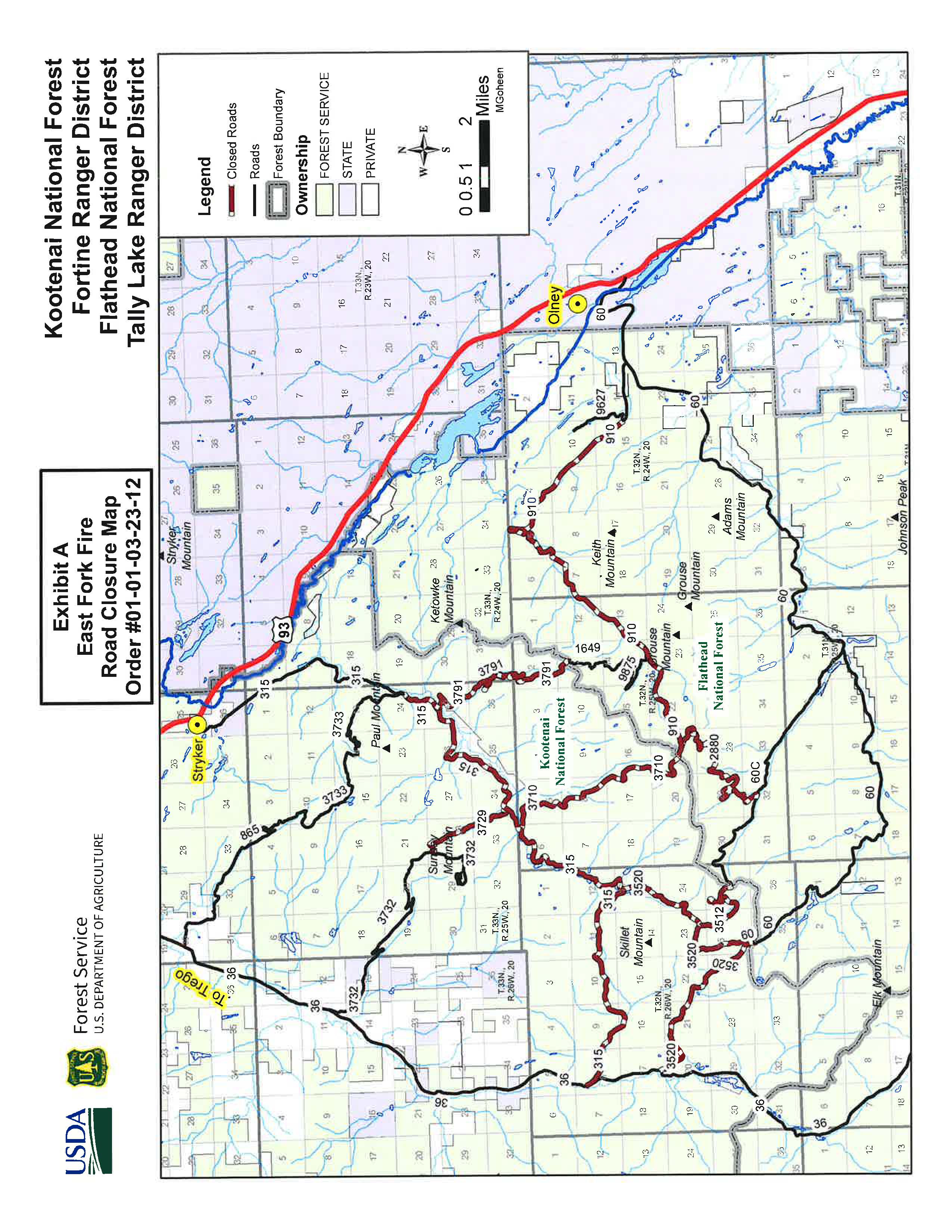
East Fork Fire Road Closure Order
Related Incident: East Fork Fire
Publication Type: Closures
The Flathead National Forest rescinded its previously issued area closure order (#01-01-08-23-20) on September 2, 2023. The Kootenai National Forest-Fortine Ranger District and the Flathead National Forest-Tally Lake Ranger District have issued a new revised road closure order (#01-01-03-23-12), effective September 2, 2023.