
Area Closure Rescinded Road Closure Amended
Related Incident: East Fork Fire
Publication Type: News
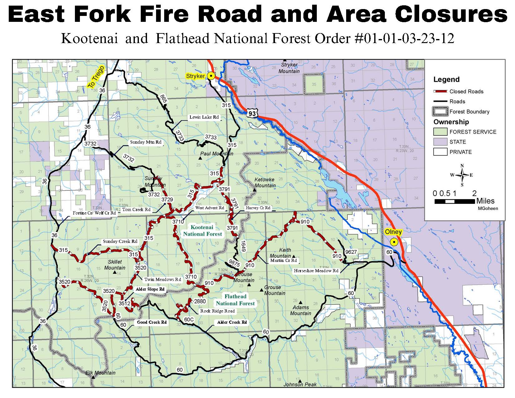
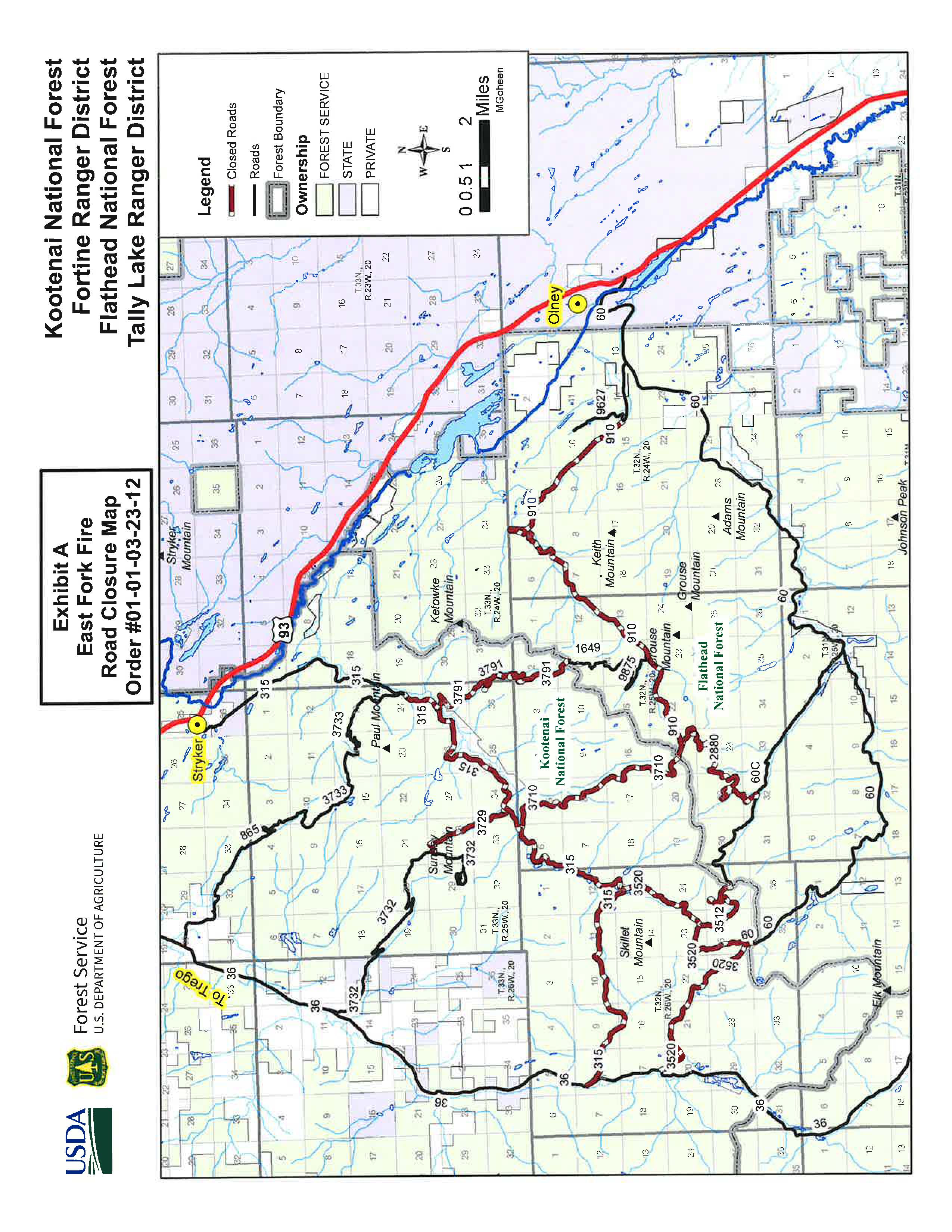
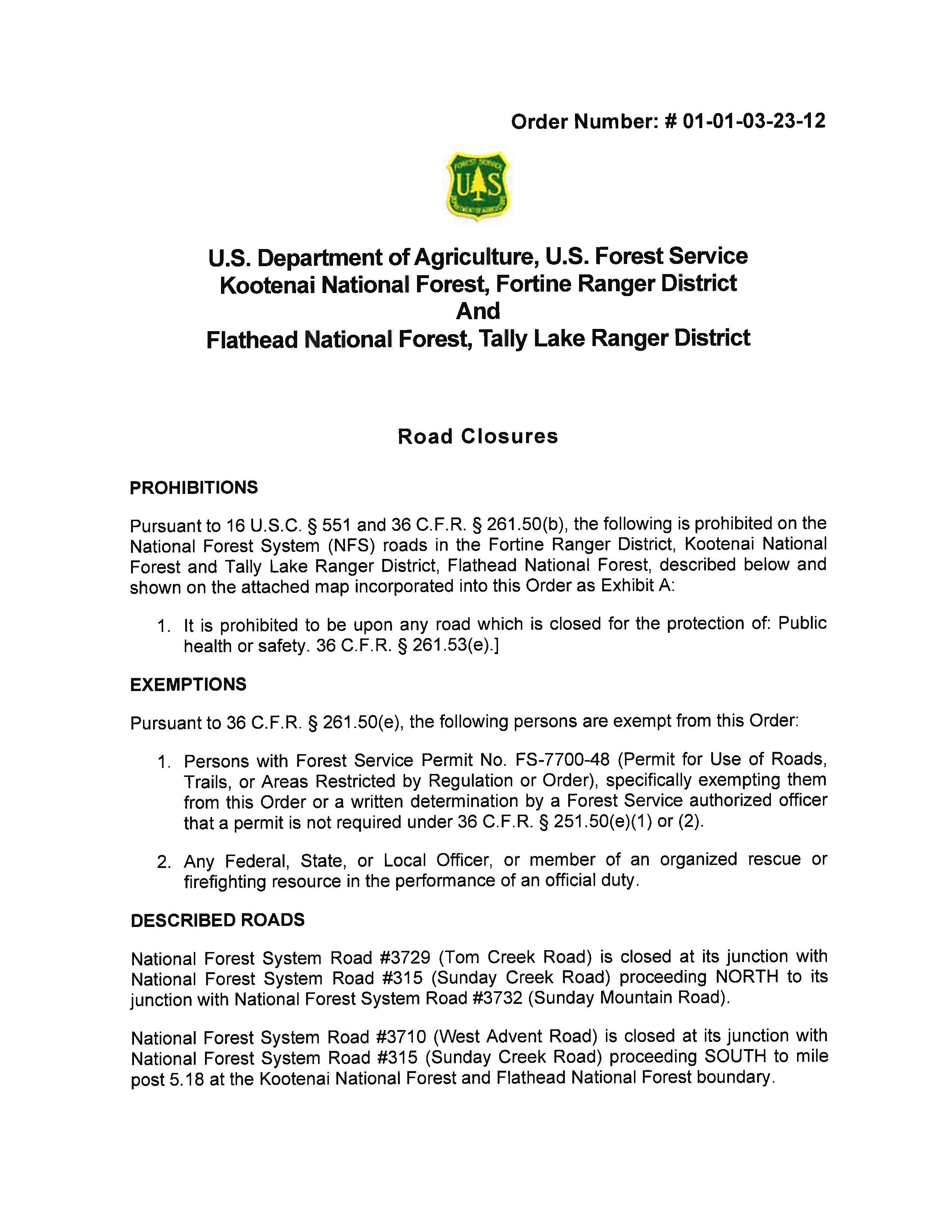
The Flathead National Forest rescinded its previously issued area closure order (#01-01-08-23-20) on September 2, 2023. The Kootenai National Forest-Fortine Ranger District and the Flathead National Forest-Tally Lake Ranger District have issued a new revised road closure order (#01-01-03-23-12), effective September 2, 2023.
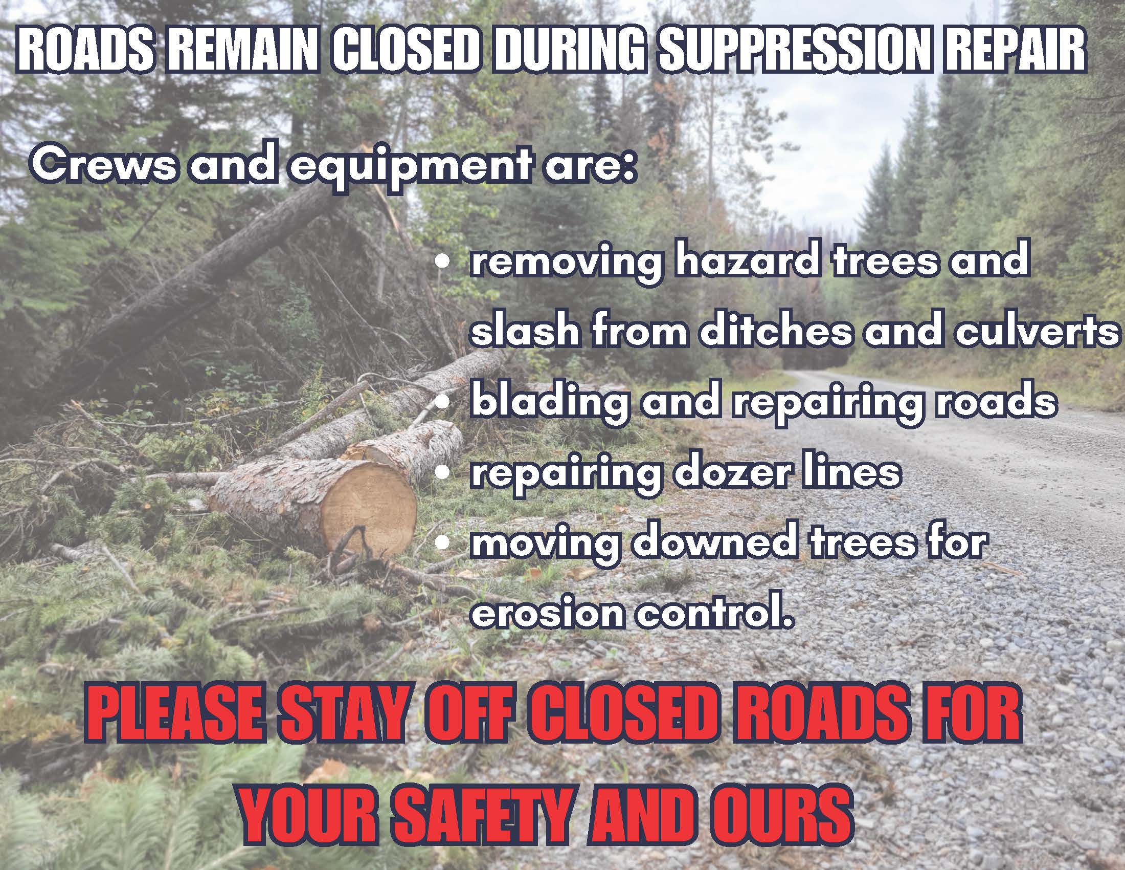
The closure order is in place to provide heavy equipment and suppression repair personnel unhindered access to areas of the East Fork fire. Work in the area includes road repair, cleaning slash and other debris out of ditches and culverts, and strategically moving logs and other downed trees to prevent erosion in burned areas.
The roads in the area are narrow, and pullouts and turnarounds are too few for heavy traffic. Temporary closures are implemented during wildfire events to protect working firefighters and equipment operators. Once agency officials determine the area is safe, closure orders will be adjusted or rescinded.
Tyee Ridge Complex Morning Update 090523
Related Incident: Tyee Ridge Complex
Publication Type: Announcement
Acreage: 7,287
Containment: 33%
Firefighters plan tactical burns to secure Tyee Ridge Complex firelines
UMPQUA, Ore. – Chilly weather last night moderated fire behavior, enabling firefighters on the Cougar Creek Fire to achieve some tactical firing operations on the north and west flanks. Infrared drone flights found hot spots that firefighters were able to mop up. On the Lighthouse Fire, night crews continued to mop up deeper into burned areas.
Today, the weather will warm into the 70s with lower humidity, but winds will remain light. Fire behavior may pick up in the afternoon due to daytime heating. Day shift crews will continue to lay firehose on more control lines. Tactical firing operations are planned on the northeast edge of Cougar Creek near the Umpqua River, weather permitting. Residents in the area may see increased smoke.
No homes were damaged or destroyed by wildfires in the Complex, which has allowed residents to return. Douglas County Sheriff is urging people to avoid unnecessary travel to those places and to drive slowly and with extra caution, especially at night.
Firefighters continue to deal with poison oak, which is prevalent throughout the county. Tecnu and Zanfel, which are different types of washes, are being provided as treatment.
Level 2 (Be Set) and Level 1 (Be Prepared) evacuation notices are still in effect. To view the current evacuation information map, go to www.dcso.com/evacuations. To shelter livestock, contact Douglas County Animal Control at 541-440-4471. Companion pets can be sheltered at Saving Grace Pet Adoption Center in Roseburg.
Oregon Department of Forestry
Joe Hessel, Incident Commander
Tyee Ridge Complex Morning Update 090523 Spanish Version
Related Incident: Tyee Ridge Complex
Publication Type: Announcement
Tamaño: 7,287 acres
Contención: 33%
Los bomberos planean quemas tácticas para asegurar los cortafuegos de Tyee Ridge Complex
UMPQUA, Ore.: El clima fresco de anoche mantuvo controlada la actividad del incendio y permitió a los bomberos en Cougar Creek realizar algunas operaciones tácticas de quema en los extremos norte y oeste. Los drones infrarrojos detectaron focos calientes que los bomberos pudieron neutralizar. En el incendio de Lighthouse, los equipos nocturnos continuaron limpiando las zonas quemadas.
Hoy, las temperaturas alcanzarán los 70º con poca humedad, pero los vientos serán ligeros. Es posible que la intensidad del fuego aumente esta tarde debido al aumento de la temperatura durante el día. Los equipos diurnos seguirán extendiendo mangueras en las líneas de control. Si el clima lo permite, se realizarán operaciones de quema táctica en el extremo noreste de Cougar Creek, cerca del río Umpqua. Los residentes de la zona podrán ver un aumento de la cantidad de humo.
Ningún hogar del complejo resultó dañado o destruido por los incendios, por lo que los residentes pudieron volver a sus casas. El sheriff del condado de Douglas recomienda a las personas que eviten los viajes innecesarios y que manejen despacio y con precaución, sobre todo durante la noche.
Los bomberos siguen lidiando con el roble venenoso que prevalece en todo el condado, y ofrecen dos tipos de lavados como tratamiento: Tecnu y Zanfel.
Permanecen vigentes los niveles de evacuación 2 (Preparado para evacuar) y Nivel 1 (Estar preparado). Para ver el nuevo mapa de evacuación vigente, visite www.dcso.com/evacuations. Para refugiar ganado, comuníquese con el Departamento de control animal del condado de Douglas al teléfono 541-440-4471. Las mascotas pueden refugiarse en el Centro de adopción animal Saving Grace, en Roseburg.
Departamento forestal de Oregón
Joe Hessel, Comandante del incidente
Tyee Ridge Complex Evening Update 090423 Spanish Version
Related Incident: Tyee Ridge Complex
Publication Type: Announcement
Tamaño: 7,287 acres
Contención: 33%
Los bomberos protegen las estructuras y se preparan para las operaciones de quema
UMPQUA, Oregón – Hoy, una fuerza especial de camiones continuó sosteniendo y mejorando los cortafuegos alrededor de los hogares a lo largo de Hubbard Creek Road. Los bomberos en el Incendio Cougar Creek, fortalecieron las líneas de topadoras, los tanques de agua bombearon agua para extinguir y remover material combustible y un dron infrarrojo mapeó posibles focos de calor cerca de las estructuras. Los helicópteros agregaron retardante para pretratar los cortafuegos para futuras operaciones de quema táctica.
Esta noche, las condciones climáticas traerán temperaturas más frescas con una visibilidad clara. Los bomberos se centrarán en fortalecer las líneas, buscando oportunidades para un ataque más directo. Se trasladaron recursos adicionales al Incendio Lighthouse para apoyar en la extinción y remoción de materiales combustibles. Hay 33 millas de cortafuegos en el Incendio Cougar Creek en los cuales las cuadrillas tienen que extinguir y remover material combustible, mitigar los árboles peligrosos y prepararse para futuras operaciones tácticas. Actualmente, el fuego se arrastra y arde. Las tempertaturas más cálidas por la tarde pudieran causar algunos brotes o el consumo de combustibles más grandes.
Mañana, existe la posibilidad de realizar operaciones de quema táctica por la tarde. El humo nuevo cerca del Incendio Cougar Creek podría ser el resultado de las quemas tácticas. Se sigue dando prioridad a la protección de estructuras, ya que el Departamento de silvicultura de Oregón ha asignado recursos adicionales en el área de Hubbard Creek Road para proteger las residencias y edificios anexos. Los recursos de ataque inicial estarán disponibles para cualquier nuevo inicio de fuego que ocurra en el área.
Para ver el mapa de información de evacuación actual, vaya a www.dcso.com/evacuations. Para albergar ganado, comuníquese con el Control de animales del condado de Douglas al 541-440-4471. Las mascotas de compañía pueden ser refugiadas en el centro de adopción de mascotas Saving Grace en Roseburg.
Departamento forestal de Oregón
Joe Hessel, Comandante del incidente
Tyee Ridge Complex Evening Update 090423
Related Incident: Tyee Ridge Complex
Publication Type: Announcement
Acreage: 7,287
Containment: 33%
Firefighters Secure Structures and Prepare for Firing Operations
UMPQUA, Ore. – Today, a task force of engines continued to hold and improve the firelines around homes along Hubbard Creek Road. On the Cougar Creek Fire, firefighters worked to secured dozer lines, tenders pumped water for mop up, and an infrared drone mapped potential hotspots near structures. Helicopters added retardant to pretreat firelines for future tactical firing operations.
Tonight, weather will provide cooler temperatures with clear visibility. Firefighters will focus on strengthening and securing lines, looking for opportunities to go more direct. Additional resources were moved to Lighthouse Fire to support mop up. Crews have 33 miles of fireline on the Cougar Creek Fire to mop up, mitigate hazard trees, and prepare for future tactical operations. Currently, the fire is creeping and smoldering. Afternoon warming may cause some flare ups or larger fuels being consumed.
Tomorrow, the potential for tactical firing operations exists in the afternoon. New smoke near the Cougar Creek Fire could be a result of conducting tactical firing. Structure protection remains a priority as Oregon Department of Forestry has allocated additional resources in the Hubbard Creek Road area to protect residences and outbuildings. Initial attack resources will be available for any new starts occurring in the area.
To view the current evacuation information map, go to www.dcso.com/evacuations. To shelter livestock, contact Douglas County Animal Control at 541-440-4471. Companion pets can be sheltered at Saving Grace Pet Adoption Center in Roseburg.
Oregon Department of Forestry
Joe Hessel, Incident Commander
Gray Fire Update 952023
Related Incident: Gray Fire
Publication Type: Announcement
Medical Lake, WA, - Current Situation: Northeast WA Incident Management Team (IMT) 3 is in command of the Gray and Oregon fires. The ICP for both the Gray and Oregon fire is located at Spokane Fire District #4 Station 41 in Deer Park, WA.
Today’s activities: Crews continue to patrol the fire area and mop-up any remaining areas of heat found along the perimeter and near homes. Crews are also working on any remaining suppression repair needs.
Evacuations: Effective today all evacuations notices throughout the entire fire area have been rescinded.
Community Meeting: There will be a community meeting on September 13, 2023 at the Medical Lake High School Gym from 6:30 PM to 8:30 PM. This meeting, led by the Spokane Conservation District and Washington Department of Natural Resources, will help answer questions landowners may have regarding post fire recovery. Topics include assessing tree survivability, salvage logging, Forest Practices and regulation, slope instability, reforestation, noxious weeds, forest health, and assistance programs.
For fire information contact the Public Information Officer at 509-508-3323
Ridge Creek Fire Daily Update September 5 2023
Related Incident:
Publication Type: News
Location: Approximately 3.5 miles east of the north tip of Hayden Lake, along the Hayden Creek Road (Forest Service Road 437) from the Ridge Creek drainage to South Chilco Mountain.
Start Date: 8/3/2023
Cause: Human-caused
Size: 4,474 acres
Containment: 60%
Total Personnel: 101
Crews: 3
Pieces of Equipment: 15-this includes a processor, log truck, loaders, excavators, dozers, skidders, feller bunchers and 3 chippers.
With the reduced fire activity and resources assigned to the fire, the next Ridge Creek Fire update will be on Thursday, September 7, 2023, with an updated map to reflect the 60% or increased containment.
The incident command post for the North Idaho Team is located at the Kootenai County Office of Emergency Management.
All fire restrictions have been lifted for the Idaho Panhandle National Forest. While campfires are no longer restricted, hunters and recreationists are urged to continue to use caution. Never leave a campfire unattended, and make sure it is cold to the touch before walking away. Please visit https://www.idl.idaho.gov/fire-management/fire-restrictions-finder for a detailed map and current information regarding fire restrictions across the state.
FIRE STATUS
Around the perimeter of the fire, crews continue to mop up hot spots and repair handlines, while excavators, chippers, graders and dump trucks worked to repair dozer lines and roads. Ongoing suppression repair work includes installing water bars and/or putting debris back on road and trail surfaces to reduce potential erosion. A few isolated hot spots remain that are located within the northern perimeter of the fire near South Chilco Mountain, which posed no threat to further spread.
Specific areas of work included grading the 406 Road and the 1511 Road east of Spades Mountain, excavator work on the 406M Road, chipper work on the 625 and dump truck and front-end loader work to repair potholes on the 437 Road.
WEATHER AND FIRE BEHAVIOR
Temperatures will remain at or below seasonal readings through Thursday. Precipitation chance will wane and a weak front on Wednesday will bring a weak warming and drying trend that arrives late this week. Temperatures will be near 70 with relative humidity around 40%. South and west winds are expected to be light at 3-10 mph.
Live and dead vegetation remains damp from recent rainfall and active flames are unlikely. Minimal fire behavior is expected as fuels remain wet, and conditions are not conductive to fire spread.
Air quality information is available at www.airnow.gov and www.wildlandfiresmoke.net.
CLOSURES AND SPECIAL MESSAGES
Kootenai County has lifted all evacuation notices. Please monitor official county sources for the most up-to-date information. https://www.kcsheriff.com/186/Emergency-Management
The temporary flight restriction for this area has been lifted.
Closure Order #01-04-03-23-003 for the Idaho Panhandle National Forest remains in place for Forest Service land north of Forest Service Road (FSR) 206, west of FSR 209 and FSR 385, and south of FSR 332; and for Forest Service land surrounding and north of the Yellowbanks Creek area and west of FSR 1535.
The closure includes all Forest Service Roads within the area:
- FSR 332, 385, 392, 428A, 437, 1507, 1511, 1530, 1552 and 1587.
- FSR 206 north of the junction with FSR 406.
- FSR 406 north of the junction with FSR 206.
- Bunco Road/FSR 332 from the National Forest boundary east to the junction of FSR 385.
- FSR 385 from the junction with Bunco Road/FSR 332 south to the junction of FSR 209 and FSR 794.
It also includes Forest Service Trails 69, 78, 234, 577 and 802.
This order is necessary for public and firefighter safety due to heavy fire traffic and equipment in the area. For more information, please see the Idaho Panhandle National Forest website at Idaho Panhandle National Forests - Alerts & Notices (usda.gov)
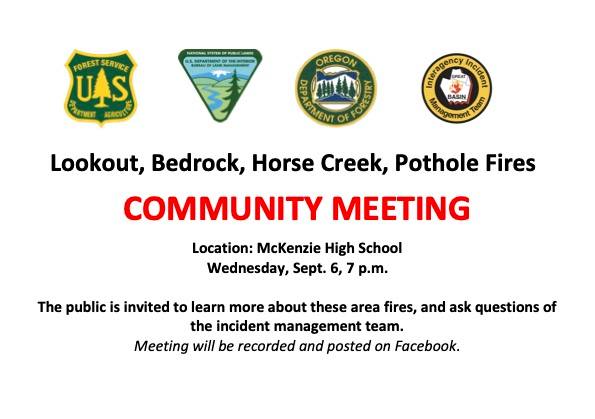
Community Meeting September 6 2023
Related Incident: Lookout FireBedrock Fire2023 Horse Creek Fire
Publication Type: Announcement
Please join Great Basin Incident Management Team #2 at the McKenzie High School tomorrow evening for information about the Lookout, Bedrock, Horse Creek, and Pothole fires.
Valentine Fire Daily Update Tuesday 5 Sep 2023
Related Incident:
Publication Type: News
Size: 50 acres
Start Date: August 16, 2023
Cause: Lightning
Completion: 30%
Total personnel: 154
Location: 11 miles northeast of Young, Arizona and 27 miles east of Payson, Arizona
Fuels: Ponderosa Pine, Hardwood litter and timber
Highlights: The Valentine fire is a lightning caused wildfire that continues to be managed under a confine/contain strategy with the goal of reintroducing fire into a fire dependent ecosystem that has been excluded for more than 50 years. The intended result of managing naturally caused fires are to reduce hazardous fuels, encourage the growth of native forage, improve range conditions, increase species diversity, protect and improve wildlife habitat, improve watershed conditions and restore ecological balance while decreasing unnaturally high accumulations of fuel thus decreasing the potential for future fires to burn with unnaturally high severity in support of the Forest Service Wildfire Crisis Strategy https://www.fs.usda.gov/managing-land/wildfire-crisis. A local Type 3 Incident Management Organization has assumed command of the fire.
Operations: Firefighters efforts will continue to improve fire control lines and focus on the protection of the many values at risk which include high voltage transmission lines, highways 260 and 512, communities of Ponderosa and Colcord Estates, range infrastructure, wildlife habitat, cultural resources, timber, recreation, and other environmental and social values. Firefighters will take advantage of moderate burn conditions by starting to ignite from 291A/291 intersection moving west along the 291 road to Colcord lookout today.
Weather: Temperatures will rise to around 77 this afternoon with continued dry conditions. A light northeast wind in the morning will transition to the southwest by late afternoon. Relative humidity this afternoon will drop into the 24-25% range after moderate overnight recoveries.
Closures: An emergency closure order for the Valentine Fire will go into effect 0600 September 5th 2023. The public is asked to avoid the fire area. The purpose of the closure order is to protect public health and safety during the Valentine Fire, and to protect assigned firefighting personnel engaging in wildland firefighting operations. Signs and gates will be in place to remind the public not to enter the fire area. https://www.fs.usda.gov/detail/tonto/home/?cid=FSEPRD910473.
Safety: The health and safety of firefighters and the public are always the highest priority. Members of the public are asked to avoid the fire area.
Smoke: Smoke from the Valentine Fire may be visible in the surrounding areas for many days. Smoke will be heavier in the mornings as it settles into the lower elevations and will lift as temperatures increase. Smoke-sensitive individuals and people with respiratory problems or heart disease are encouraged to take precautionary measures An interactive smoke map at https://fire.airnow.gov/ allows you to zoom into your area to see the latest smoke conditions.
Information Links and Contacts:
Tonto National Forest https://www.fs.usda.gov/main/tonto/fire
InciWeb https://inciweb.nwcg.gov/incident-information/aztnf-valentine-fire
Fire Email 2023.valentine@firenet.gov
Fire Information Line (928) 362-0101 • Office Hours: 8:00 AM – 8:00 PM
Humboldt County Alert Evacuation Downgraded 90523
Related Incident: 2023 SRF Lightning Complex and Redwood Lightning Complex
Publication Type: Announcement
HUMBOLDT ALERT - EVACUATION DOWNGRADE, ZONE HUM-E008-B
2023-09-05 11:19:26 PDT
1145830165713383
THIS IS A HUMBOLDT ALERT. Due to improving conditions on the 2023 SRF Lightning Complex, zone HUM-E008-B has returned to normal status. There is no longer an Evacuation Warning in place for this zone. For more information go to humboldtsheriff.org/emergency. THIS IS A HUMBOLDT ALERT.