
Tyee Ridge Complex Morning Update 090623 Spanish Version
Related Incident: Tyee Ridge Complex
Publication Type: Announcement
Tamaño: 7,366 acres
Contención: 35%
Los bomberos siguen fortaleciendo y controlando el perímetro del incendio
UMPQUA, Oregon. – Dentro del Tyee Ridge Complex, en los incendios de Cougar Creek y Lighthouse, los equipos de noche se concentraron en limpiar y controlar las líneas donde se había realizado el trabajo de quema durante el día. Por la noche, los camiones patrullaron Hubbard Creek Road y el personal continuó fortaleciendo las líneas de control y mitigando los peligros.
nóstico de clima seco de hoy debe permitir que los bomberos continúen las operaciones de quema táctica en el incendio de Cougar Creek. Puede ser que las cuadrillas vean el consumo de combustibles más grandes a medida que la quema táctica tiene éxito en las secciones por el interior del incendio. En el perímetro occidental del incendio de Cougar Creek, las cuadrillas continúan limpiando y mitigando los peligros a lo largo de Bear Creek Road. Al extremo sur, están preparando líneas de topadoras cerca del embalse Grier para llevar a cabo posibles operaciones de quema.
La prioridad operativa va cambiando de una de lucha contra incendios hacia una de limpieza. Las cuadrillas todavía enfrentan peligros al trabajar en áreas quemadas donde los combustibles se quemaron anteriormente. Los bomberos están lidiando con terrenos escarpados, peligros aéreos y bolsas de quemaduras subterráneas.
Los avisos de evacuación de Nivel 2 (Listo para evacuar) y Nivel 1 (Estar preparado) siguen vigentes. Para ver el mapa de información de evacuación actual, vaya a www.dcso.com/evacuations. Para albergar ganado, comuníquese con el Control de animales del Condado de Douglas al 541-440-4471. Las mascotas de compañía pueden ser refugiadas en el centro de adopción de mascotas Saving Grace en Roseburg.
Equipo 1 del Departamento forestal de Oregón
Joe Hessel, Comandante del incidente
Camp Creek Fire Update for Wednesday September 6
Related Incident: Camp Creek Fire
Publication Type: News
Fire Size: 1,922 acres
Containment: 16%
Total Personnel: 573
Weather and Fire Behavior:
Warm, dry weather with clear skies is expected through the week. Winds will remain out of the west, moving in an easterly direction.
The fire is burning in very heavy surface fuels, including rotten logs, branch wood and deep duff under a timber canopy. The timber understory is made up of Douglas fir, western hemlock, and western red cedar. Following the rains over the weekend, current fire behavior includes widespread smoldering and creeping. Strategic firing operations will be implemented in the coming days as the weather warms up to secure the fire’s edge to control lines before the fuels dry out too much or high winds materialize.
Operations:
Recent cool and moist weather has dampened fire activity, thereby allowing firefighters a favorable window to remove trees along roads, take out ladder fuels (i.e., liches, mosses, shrubs, lower limbs of trees), install water systems, and mop-up the fire’s edge where firefighters were able to go direct or conduct firing operations to bring the main fire to our control lines. These actions contributed to containment – as indicated by the black line – on portions of Forest Service Roads 1210, 14 and 12. Crews will continue to mop up, which means removing any heat along the containment line, when fire meets these areas.
Firefighters are always looking ahead and planning for numerous scenarios at any given time. They are currently working on prepping the 1211 Road by removing ladder fuels using masticators and other fire equipment to establish indirect control lines which will be burned out if needed to secure the east flank. Contingency work is ongoing to the southeast of the fire. Fuels will be removed along old logging roads using masticators and feller bunches. This action will open up roads to act as a fuel break or contingency lines if needed.
Fire information officers will be stationed at the Hoodland Senior Center in Welches, OR at 1:00 p.m. this afternoon to provide updates and answer questions. A community meeting is scheduled for 6:30 p.m. today at the Mt. Hood Lions Club in Welches, OR. We will attempt to livestream the meeting on Facebook: https://www.facebook.com/campcreekfire.
Additional Information:
Current smoke outlook: https://outlooks.wildlandfiresmoke.net/outlook/2c7a8f9b.
Closures and Evacuations:
Barlow Wayside Park and the Sandy Ridge Recreation Site are temporarily closed due to fire activity. Clackamas County residents can sign up at https://www.clackamas.us/dm/publicalerts to receive emergency alerts via email, phone, or text.
Temporary Flight Restriction (TFR):
A TFR is issued over the fire area, which excludes public drone use. If you fly a drone over a fire, air operations could be suspended until the risk of a mid-air collision with a drone is resolved.
Safety:
Please exercise caution while driving as there are engines and other fire equipment on the road along with school buses now that school is back in session.
Video:
Click the link below to view today's morning video update by Operations Section Chief Matt Call.
You Tube Video: Morning Video Update for Wednesday, September 6 (6:22)
Valentine Fire Daily Update Wednesday September 06 2023
Related Incident:
Publication Type: News
Size: 303 acres
Start Date: August 16, 2023
Cause: Lightning
Completion: 30%
Total personnel: 130
Location: 11 miles northeast of Young, Arizona and 27 miles east of Payson, Arizona
Fuels: Ponderosa Pine, Hardwood litter and timber
Highlights: Firefighter’s were able to successfully complete tactical firing operations yesterday around infrastructure which include powerlines that are in the fire area.
Operations: Fire managers plan to take advantage of favorable conditions and reintroduce fire at low to moderate intensities minimizing impacts to wildlife, culturally sensitive areas, critical infrastructure, and community watersheds. Tactical firing operations include ground resources conducting hand firing operations along FS RD 512 to the east and FS RD 291 along the north perimeter. These roads will be used as containment features keeping the fire from extending to the north and east.
Fire Ecology: The Valentine Fire is the first step in restoring fire to a fire-adapted ecosystem which historically burned at least every 10 years. Fire has been absent for well over 50 years and, during that time, litter, duff, and woody debris accumulated to unnaturally high levels. The excessive fuel could support unnaturally severe fire effects and extreme fire behavior if it burned under more extreme conditions. The moisture from the last few weeks, combined with carefully chosen ignition patterns and patience, is allowing the Valentine Fire to burn with desirable fire behavior that is producing beneficial results. The Valentine Fire is considered a ‘first entry’ because it has been so long since the area last burned. It will produce more smoke than subsequent fires as it acts as nature’s janitor, cleaning up the excessive fuel accumulation. https://www.fs.usda.gov/managing-land/wildfire-crisis.
Weather: Dry conditions will persist through the weekend. Temperatures will gradually warm to above normal levels into the middle to upper 80s with relative humidity dropping below 20% each afternoon. A consistent southwest daytime wind will shift more westward later this week. Cloud cover increases over the weekend with slight chances of rain showers returning early next week.
Closures: An emergency closure order is in effect for the Valentine Fire as of 0600 September 5th 2023. The public is asked to avoid the fire area. The purpose of the closure order is to protect public health and safety during the Valentine Fire, and to protect assigned firefighting personnel engaging in wildland firefighting operations. Signs and gates will be in place to remind the public not to enter the fire area. https://www.fs.usda.gov/detail/tonto/home/?cid=FSEPRD910473.
Safety: The health and safety of firefighters and the public are always the highest priority. With hunting season upon us we want to remind all hunters in Unit 23 to be vigilant and watch out for fire equipment.
Smoke: Smoke from the Valentine Fire may be visible in the surrounding areas for many days. Smoke will be heavier in the mornings as it settles into the lower elevations and will lift as temperatures increase. Smoke-sensitive individuals and people with respiratory problems or heart disease are encouraged to take precautionary measures An interactive smoke map at https://fire.airnow.gov/ allows you to zoom into your area to see the latest smoke conditions.
Information Links and Contacts:
Tonto National Forest https://www.fs.usda.gov/main/tonto/fire
InciWeb https://inciweb.nwcg.gov/incident-information/aztnf-valentine-fire
Fire Email 2023.valentine@firenet.gov
Fire Information Line (928) 421 4579 • Office Hours: 8:00 AM – 8:00 PM
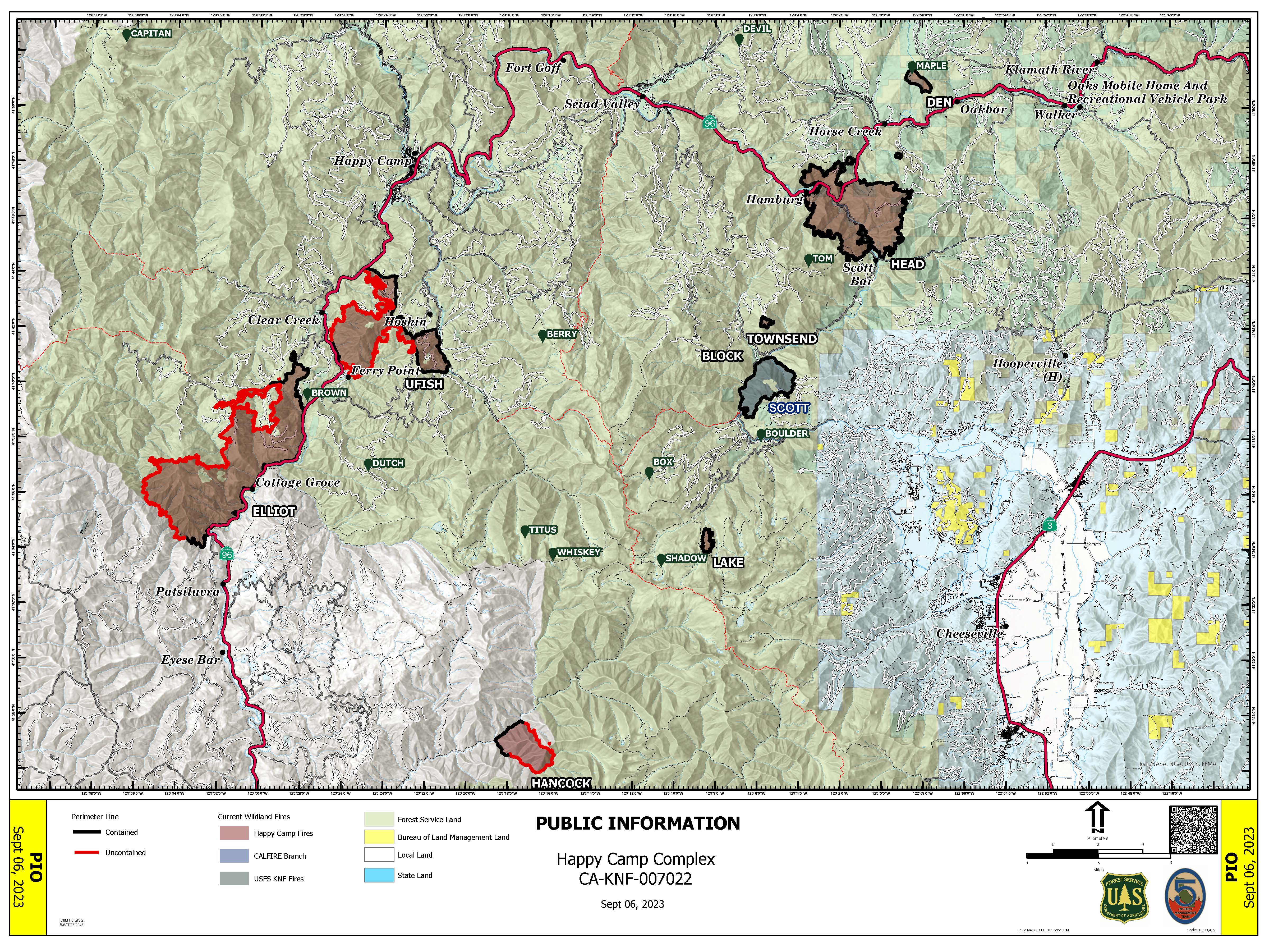
Happy Camp Complex Incident Update September 6 2023 Morning
Related Incident: 2023 Happy Camp Complex Klamath NF
Publication Type: News
VIRTUAL PUBLIC MEETING: A virtual public meeting will be held today, September 6th, at 5:30 p.m. Fire personnel will provide an operational overview of the fire situation. The meeting will be live-streamed on Facebook (facebook.com/KlamathNF) and YouTube (youtube.com/@ciimt5). A Facebook account is not necessary to view the meeting.
Tomorrow at 7:00 a.m., a transition of command will take place. California Interagency Incident Management Team 5 and Incident Commander Dustan Mueller will transition command of the Happy Camp Complex to Northern Rockies Complex Incident Management Team 2, under the command of Incident Commander Scott Schuster.
WEST SIDE OVERVIEW (ACRES/CONTAINMENT): Elliot (12,129 acres, 51%), Ufish (5,105 acres, 33%), Hancock (1,738 acres, 21%)
Last night, fire activity was minimal on the west side of the Happy Camp Complex. Firefighters on the Elliot Fire observed less rolling debris near State Route 96. Crews will be working to build more fire line near Pony Peak south toward Dillion Creek, where the fire is holding. They will also work east toward Swillup Creek. Firefighters on the Ufish plan to carry out strategic firing operations with the goal of removing dense vegetation to reduce the chance of the fire making a run toward Happy Camp. Smoke from this operation may be seen in surrounding communities. More resources will be flown into the Hancock Fire today. Firefighters have already gained 21 percent containment and will be working on the plan to prevent the fire from moving to the north and east.
EAST SIDE OVERVIEW (ACRES/CONTAINMENT): Head (6,940 acres, 100%), Townsend (81 acres, 100%), Den (294 acres, 100%), Scott (1,886 acres, 100%), Lake (199, acres, 100%)
As of last night, firefighters on the Head Fire secured the remaining section of open line and achieved 100% containment. Today, additional suppression repair work will take place on the Head and Scott fires. The remaining personnel on the Lake Fire will leave the area today. All fires on the east side of the complex will continue to be observed by infrared flights that can detect residual heat on the land.
EVACUATIONS: View current Siskiyou County evacuation orders and warnings by visiting: https://community.zonehaven.com. Siskiyou County residents are encouraged to sign up for rapid emergency notifications using the CodeRED emergency alert system at: www.co.siskiyou.ca.us/emergencyservices/page/codered-emergency-alert
ROAD CONDITIONS: No road work will be performed on State Route 96 through Wednesday, September 6th, at 7 a.m., to allow for holiday travel. Please keep in mind that one-way traffic control will remain in place from 2.8 miles west of Dillon Road to 8.8 miles east of Dillion Road, as this remains in an active fire area for the Elliot Fire. Motorists can expect up to 30-minute delays in this area. County road closures will be listed on the Siskiyou County Public Works website: www.co.siskiyou.ca.us/publicworks/page/closures-and-delays
FOREST CLOSURES: Two closure orders have been implemented: Happy Camp Complex Emergency Fire Closure No. 05-05-23-06 and No. 05-05-23-08. Additionally, fire restrictions remain in place to help minimize the chances of human-caused wildland fires. These restrictions prohibit campfires outside of designated improved recreation areas and wilderness. View closure orders, fire restrictions, and maps at: www.fs.usda.gov/alerts/klamath/alerts-notices
TEMPORARY FLIGHT RESTRICTION (TFR): A TFR has been established over the fire area. Flight restrictions include the use of drones. The operation of drones under the TFR is prohibited.
PACIFIC CREST TRAIL: All Pacific Crest Trail closures within the Klamath National Forest have been reopened.
AIR QUALITY: For information regarding smoke impacts and what you can do to protect yourself, visit the Siskiyou County Air Pollution Control District Fire and Smoke Information website at: www.co.siskiyou.ca.us/airpollution/page/fire-and-smoke-information or AirNow.gov
Lookout Bedrock Horse Creek Pothole Fires Daily Update 962023
Related Incident: Lookout FireBedrock Fire2023 Horse Creek Fire
Publication Type: News
Lookout/Horse Creek/Pothole Fires/Bedrock
September 6, 2023
Morning Update
Please join us tonight for a community meeting at the McKenzie High School Gymnasium at 7pm. The Great Basin Incident Management Team 2 will provide an overview of the fires and answer questions that participants might have.
Lookout: Total Personnel: 780
Size: 24,404 acres l Start Date: August 5, 2023 l Cause: Lightning l Containment: 20%
Resources: 28 engines l 14 crews l 6 bulldozers l 25 water tenders l 9 masticators l 5 helicopters l 1 Skidder
Yesterday’s fire activity was low due to cooler temperatures and cloud coverage in the morning. New infrared flights provided more accurate mapping showing a reduction in acreage. On the northern side of the fire, crews will look to connect primary lines to existing road and trail networks. Mastication and log hauling will also continue to advance containment lines. Westside fire operations will continue with equipment and firefighters looking to merge primary and alternate lines. As conditions allow, aviation resources will support suppression efforts.
Horse Creek: Total Personnel: 154
Size: 765 acres l Start Date: August 24, 2023 l Cause: Lightning l Containment: 30%
Resources: 11 engines l 3 crews l 4 bulldozers l 9 water tenders l 3 masticators l 3 Skidders l 1 Excavators
On Tuesday, firefighters’ efforts increased containment. Crews will monitor the eastern side of the fire where significant heat continues to hold in steep rugged terrain. Engines will carry on extinguishing, patrolling roads and removing burning material along completed fire lines.
Pothole: Total Personnel: 54
Size: 109 acres l Start Date: August 25, 2023 l Cause: Lightning l Containment: 35%
Resources: 3 engines l 1 crews l 3 water tenders
Fire activity was minimal yesterday giving crews the opportunity to increase containment lines. Patrolling and mop up operations on forest road 356 and fire lines will progress throughout the day to secure the fires perimeter.
Bedrock: Total Personnel: 403
Size: 31,590 acres l Start Date: July 22, 2023 l Cause: under investigation l Containment: 90%
Resources: 17 engines l 11 crews l 3 bulldozers l 17 water tenders l 7 masticators l 5 helicopters l 4 Skidder
The suppression group, in conjunction with the repair group, will continue falling dangerous trees on the west side of the fire. Crews will continue clearing and chipping operations on the north and south sides. Excess fire equipment; pumps, hose, and portable water tanks continue to be removed and returned to base camp for servicing and cleaning as the fire moves towards patrol status.
Weather
Warmer and dryer conditions will persist over the next few days. Evening temperatures will remain cool. Relative humidity will hover around 30-40% while daytime temperatures remain steady in the 70’s with potential to increase over the next few days. Winds will be coming from the west to northwest ranging from 4 to 8 mph.
Evacuation Update
Lane County Sheriff have been consistently assessing the Evacuation levels as firefighters increase containment. Additional information and potential revisions can be found at the following websites.
Lane County Evacuations: https://www.lanecountyor.gov/cms/one.aspx?pageId=19729054
Linn County Evacuations: https://www.linnsheriff.org/
Evacuation Centers: An evacuation center is in place at Westridge Middle School in Oakridge for evacuees and small pets from the Horse Creek and Lookout Fires. For assistance with large animal evacuations, please call 541-285-8227.
Road Closures:
Highway 242, McKenzie Highway, is closed between milepost 61-76, 14 miles west of Sisters, Oregon to just east of the junction with Highway 126. Highway 126 is currently open. Please monitor Trip Check for any updates at: https://tripcheck.com/
Forest Closures: Willamette National Forest reduced the closure area for the Bedrock fire due to successful firefighting efforts. Many popular sites and trails have re-opened including the Alpine Trail. There are no changes to closure areas for the Lookout, Horse Creek, and Pothole fire areas at this time. These closures help provide firefighters with safer driving conditions and decrease the potential for search and rescue operations that could interrupt firefighting activities. Closures can be found at: https://www.fs.usda.gov/detail/willamette/alerts-notices/?cid=fseprd552029
Restrictions: Fire Restrictions are in place on the Willamette National Forest: https://www.fs.usda.gov/willamette. Temporary Flight Restrictions remain in place over the Bedrock and Lookout fire areas.
Smoke Outlook: https://outlooks.wildlandfiresmoke.net/outlook/4c92bc1a The Fire and Smoke Map (fire.airnow.gov) is another source for air quality information.
Lookout Information Line: 541-215-6735 (8 a.m. - 8 p.m.)
Email: 2023.lookout@firenet.gov
Facebook: https://www.facebook.com/LookoutFire2023
Inciweb: https://inciweb.nwcg.gov/incident-information/orwif-lookout-fire
Bedrock Fire Information: 541-414-6272 (8 a.m. - 8 p.m.)
Email: 2023.bedrock@firenet.gov
Facebook: https://www.facebook.com/BedrockFire2023/
InciWeb Bedrock: https://inciweb.wildfire.gov/incident-information/orwif-bedrock-fire
Update Chilcoot and Ridge Fires September 6 2023
Related Incident: 2023 Chilcoot Fire UNF2023 Ridge Fire UNF
Publication Type: News
The Chilcoot Fire is currently 1,775 acres with 5% containment. The Ridge Fire is currently 238 acres with 75% containment. There are currently 724 personnel assigned to the incident.
There will be a Virtual Community Meeting for the Chilcoot and Ridge Fires on Thursday, September 7th at 7:30 pm on the Chilcoot and Ridge Fires 2023 Facebook page.
The school year has begun as well as bowhunting season. This brings more traffic onto the local roads, so we ask for the public’s patience and awareness of the additional traffic brought by our wildland fire crew vehicles and heavy equipment.
Yesterday the fires saw no significant changes as crews diligently performed activities ranging from going direct and constructing handline, to installing hose lays and employing various pieces of heavy equipment for specialized tasks. Overall, the weather proved favorable to firefighting, realigning resources between fires and for supporting the team’s dynamic operations.
Chilcoot Fire: The indirect line along the southwest is nearly done and will extend all the way over to the east flank. Along that flank, the 300 Road has been prepped as a contingency line and the chipping is completed. Handline has been accomplished 20 feet into the fire along the north flank wherever possible given the limitations of the rocky terrain. Firefighters discovered a holdover lightning fire to the north but within the contingency line. A helicopter dropped buckets of water and a crew remained overnight to patrol it.
Ridge Fire: Containment remained unchanged but that doesn’t reflect the amount of work performed yesterday. Mop up is continuing 50 feet into the fire line, strengthening and adding depth to the lines. However, the soil needs to be evaluated for heat for several days to consider sections as being safely completed. The remaining firefighters are focused on key tasks, including a Type 1 wildland fire module (WFM) that will remain for a few days. A 7-10 member WFM provides an innovative, highly mobile, versatile, and logistically independent team.
Weather: The rain has subsided, likely for over a week. There is almost no chance of precipitation as temperatures will increase as the fuel moisture gradually decreases. Ridge winds will increase this week and by Thursday enable the heat in the embers to cause localized smoke. The canyons are retaining their moisture and this inversion will cause morning mists.
Closures: There is a forest closure for portions of the Umpqua National Forest in response to fire activity in the area to protect public and wildland firefighter safety. A Closure Order for the Canton Creek area has been issued by Bureau of Land Management (BLM): Chilcoot Ridge Fire Emergency Closure Order BLM Roseburg District. There is a Temporary Flight Restriction over the fire area.
Fire Information: (541) 900-5862, 8:00 AM – 7:00 PM Email: 2023.chilcoot@firenet.gov
Petes Lake Fire Update September 6 2023
Related Incident: Petes Lake Fire
Publication Type: News
Resources: 229 Total Personnel | 3 Hand Crews | 3 Dozers | 4 Helicopters |8 Engines | 8 Masticators | 2 Water Tenders
Central Oregon – The Petes Lake Fire was started by a lightning strike on Friday, August 25, near the border of the McKenzie River Ranger District of the Willamette National Forest and the Bend Fort-Rock Ranger District of the Deschutes National Forest in the Mink Lake Basin area of the Three Sisters Wilderness. The fire has burned 328 acres, five miles west of Elk Lake.
The fire continues to hold within its perimeter, creeping and smoldering with minimal smoke dispersal. The fire is burning in an area with rock outcroppings and difficult access. Limited fire growth has allowed firefighters and equipment operators to have a productive day working on the shaded fuel break along the Cascade Lake Highway. Part of the strategy for this fire involves identifying and strengthening fire control features, such as this one.
To achieve the fuel break specifications, hand crews and heavy machinery operators need to be able to work safely near the edge of the highway. One piece of heavy equipment, called a masticator, is highly efficient but often flings large chunks of wood debris for hundreds of feet. It cannot be safely operated near traffic.
To ensure that work can be completed as safely and efficiently as possible, Cascade Lakes Highway will be closed from Elk Lake to Lava Lake from 8 a.m. – 7 p.m. for the next two days.
Drivers can detour around the closure using the primitive Forest Service Road 4625/Elk Lake Loop. A marked pilot car will be used to guide vehicles. Motorists are asked to stay with the pilot car and not turn around or stop. Additional traffic signs, variable message boards and road guards are in place to increase safety. Cooperation from the public will help fire crews and equipment operators complete this work quickly and with minimal impact to local businesses. Fire managers thank the public for their patience. Travelers can avoid delays (and the detour on the primitive forest road) by accessing the lower portion of the Cascade Lakes Highway area via Forest Road 40 from Sunriver.
Fire managers have developed a Structure Assessment and Protection Plan for the Elk Lake community. The plan has maps that show locations of homes and lists firefighting resources needed to protect structures and other values at risk. In the event that Petes Lake or future fires approach this community, the plan will help firefighters be more efficient in their efforts to defend structures.
Weather: In the next few days, the weather is expected to be warm and more seasonable, with lower humidity. Solar heating and light winds could increase the potential for fire activity.
Evacuations: The Deschutes County Sheriff lifted the Level 1 Evacuation Notice for the areas east of the Cascade Lakes Highway around Elk and Lava Lakes. The Level 3 (Go Now) Evacuation Notice is still in place for all areas west of the Cascade Lakes Highway from the Lucky Lake Trailhead north to the Mirror Lake Trail. This includes the areas around Lucky Lake, Leech Lake, Doris Lake, Blow Lake and Mirror Lakes. Evacuation notices and updates can be found at: www.deschutes.org/emergency.
Closures: The closure order on the Willamette and Deschutes National Forests for the Petes Lake Fire remains in place and information can be found at: fs.usda.gov/detail/deschutes/news-events/?cid=FSEPRD1134682. Resorts along the Cascade Lakes Highway remain open for business, though visitors may encounter delays with road flaggers and pilot cars. The Wanoga SnoPark, Kapka SnoPark, Mirror Lake Trailhead and Point Campground are temporarily closed to the public.
Safety: The public can help firefighters by obeying trail closures and following the detour instructions in the shaded fuel break work areas. Keep vehicle and bike speeds low near work areas. Follow all fire restrictions.
List of Community Fire Information Displays
Related Incident: Camp Creek Fire
Publication Type: News
Printed information, posted in key locations, is an important tool to inform local residents and travelers about a nearby wildfire. Public information officers post new information at these locations each day, in a process they call “running the trapline.” Businesses or organizations give permission for fire information staff to place a display board or leave printed flyers at their location. Information officers spend the morning preparing documents for distribution, then hit the road in the afternoons to drop off or post the new publications.
You can find fire information at the following locations at least through the weekend (September 10). When you see Camp Creek Fire information displayed here, please thank that establishment or organization for providing a valuable service to the community.
- Mt. Hood Ranger Station - 16400 Champion Way, Sandy
- Boring Fire Station - 28655 SE Highway 212, Boring
- Sandy Safeway - 37601 Highway 26, Sandy
- Jonsrud View Point - SE Bluff Road, Sandy
- Ant Farm Cafe - 39140 Proctor Blvd., Sandy
- Sandy Fire Station - 17460 Burns Avenue, Sandy
- Brightwood Post Office - 20275 E. Ambrose Street, Brightwood
- Wildwood Rec Site - BLM - 65670 E. Highway 26, Welches
- Welches Post Office - 24407 E. Welches Road, Welches
- Coffee Brewsters - 68224 E. Highway 26, Welches
- Hoodland Thriftway - 68280 E. Highway 26, Welches
- Zigzag Ranger Station - 70220 E. Highway 26, Zigzag
- Mt. Hood Foods - 73265 E. Highway 26, Rhododendron
- Rhododendron Post Office 73287 E. Highway 26, Rhododendron
- Corbett Country Market - 36801 Historic Columbia River Highway
- Aims Church - 44510 SE Connett Road, Corbett
Oregon Fire Update 962023
Related Incident: Oregon Fire
Publication Type: News
Oregon Fire Update 9-6-2023
Fire Size: 10,817 acres
Initial Start: 8/18/2023 at 1600 pm
Location: Approximately 4 miles northeast of Elk, WA.
Cause: Human- Still under investigation
Containment: 91%
Resources Committed:
13 Engines, 5 Crews, 1 Bulldozer, 6 Water Tenders, 2 Skidgens
Personnel: 181
Road Closures: None
Elk, WA, - Current Situation: Northeast WA Incident Management Team 3 is in command of the Oregon and Gray fires. The Oregon Fire continues to remain within the current footprint with no further growth, the strategy remains full suppression and work is progressing as expected. Northeast WA Incident Management Team 3 will continue
Oregon Fire Update 9-6-2023
Fire Size: 10,817 acres
Initial Start: 8/18/2023 at 1600 pm
Location: Approximately 4 miles northeast of Elk, WA.
Cause: Human- Still under investigation
Containment: 91%
Resources Committed:
13 Engines, 5 Crews, 1 Bulldozer, 6 Water Tenders, 2 Skidgens
Personnel: 181
Road Closures: None
Elk, WA, - Current Situation: Northeast WA Incident Management Team 3 is in command of the Oregon and Gray fires. The Oregon Fire continues to remain within the current footprint with no further growth, the strategy remains full suppression and work is progressing as expected. Northeast WA Incident Management Team 3 will continue their efforts through the 11th before turning the fire back to local resources next week.
Today’s activities: Mop-up, patrol and suppression repair will continue across all divisions of the fire. More resources are planned to be released today as the team continuously works to right size the incident.
Evacuations: All evacuations throughout the entire fire area have been rescinded.
Weather: A subtle warming and drying trend will begin today and continue through the week. Look for mid and high-level clouds passing through in the morning giving way to fair afternoon cumulus. Winds will be light and variable in the early morning with speeds generally under 10mph. the drying of the airmass will equate to cooler morning lows in the 40’s while highs rebound in the 70’s.
For fire information contact the Public Information Officer at 509-508-3323 or email 2023.oregon@firenet.gov
Oregon Fire Public Information
Phone: 509-508-3323
Email: 2023.oregon@firenet.gov
Inciweb: https://inciweb.wildfire.gov/incident-information/wanes-oregon-fire
Facebook: https://www.facebook.com/newfireinfo
Today’s activities: Mop-up, patrol and suppression repair will continue across all divisions of the fire. More resources are planned to be released today as the team continuously works to right size the incident.
Evacuations: All evacuations throughout the entire fire area have been rescinded.
Weather: A subtle warming and drying trend will begin today and continue through the week. Look for mid and high-level clouds passing through in the morning giving way to fair afternoon cumulus. Winds will be light and variable in the early morning with speeds generally under 10mph. the drying of the airmass will equate to cooler morning lows in the 40’s while highs rebound in the 70’s.
For fire information contact the Public Information Officer at 509-508-3323 or email 2023.oregon@firenet.gov
Bosque Nacional Seis Ros Complejo Smith RiverSur Lunes 6 de Septiembre de 2023
Related Incident: Smith River Complex
Publication Type: News
Acres: 85,520
Contención: 19%
Causa: Relámpagos
Fecha de inicio: 15 de Agosto
Recursos: 56 tripulaciones, 146 camiones de bomberos , 10 helicópteros, 4 drones, 16 topadoras, 21 masticadores, 1 minicargadoras, 36 cisternas de agua
Personal: 2,511
SITUACIÓN ACTUAL: Desde hace varios días, los bomberos preparan y aplican un amplio plan de extinción. Están utilizando todos los recursos disponibles (incluidos equipos pesados, motores, cuadrillas de mano, cuadrillas de expertos y aviones) para construir y mejorar líneas de contención y, al mismo tiempo, extinguir el Kelly fuego directamente a lo largo de su perímetro donde sea seguro hacerlo. En áreas donde las cuadrillas no pueden acceder de manera segura al perímetro del incendio, llevarán a cabo operaciones de incendio tan pronto como los niveles de humedad de la vegetación y las condiciones climáticas lo permitan. Un equipo experto en el lado suroeste del incendio realizó una quema de prueba el martes, pero la vegetación no soportó adecuadamente el fuego, por lo que el equipo no procedió. Hoy, las cuadrillas que trabajan en elevaciones más altas en el lado este pueden realizar otra quema de prueba en un sitio más seco. Es probable que la producción de humo sea mínima hoy. Sin embargo, si las igniciones controladas pueden comenzar hacia el final de la semana, Se espera ver un aumento en el humo, principalmente a lo largo de los lados sur y este del incendio Kelly.
CLIMA Y COMPORTAMIENTO DEL INCENDIO: El martes fue el primer día de pleno sol sobre el incendio desde el 31 de agosto. Sin embargo, el comportamiento del fuego fue mínimo, consistiendo principalmente en arder y arrastrarse, porque el paisaje y la vegetación permanecen húmedos debido a las recientes precipitaciones, las altas humedades nocturnas y los vientos ligeros. Aunque la tendencia a largo plazo de calentamiento y sequía continuará, se espera que el miércoles sea un poco más fresco y húmedo, y la actividad de incendios debería volver a ser muy baja. Mientras sea posible que se produzcan incendios persistentes tras los rayos del fin de semana pasado, el grupo de ataque inicial permanecerá en el lugar y responderá rápidamente a los informes de nuevos incendios.
CIERRES: La autopista 199 está abierta a todo el tráfico, se esperan retrasos en los viajes de hasta 45 minutos. Existe un control de tráfico pilotado unidireccional entre Sandy Beach (cerca de la milla 21) y Oregon Mountain Road (cerca de la milla 31). El segmento pilotado cambiará a medida que los equipos reparen barandillas quemadas, retiren rocas de la carretera y eliminen árboles peligrosos.
Los terrenos, caminos, senderos y sitios de recreación del Bosque Nacional Six Rivers en las cercanías del Complejo están cerrados (Orden Forestal No. 10-23-06). La Orden y el mapa se pueden ver en esta página web del Bosque Nacional Six River: tinyurl.com/4atens8c.
EVACUACIONES: El martes, la Oficina del Sheriff del Condado de Del Norte levantó la orden de evacuación de Nivel 1 (Prepárese) para el área de Hiouchi. Incluso en ausencia de órdenes de evacuación, todos los residentes que viven en áreas propensas a incendios siempre deben estar preparados y tener una mentalidad de "Prepárense". Las órdenes de evacuación de nivel 2 y 3 siguen vigentes. Vea el mapa de evacuación interactivo en línea para obtener la información más actualizada sobre evacuaciones: tinyurl.com/yp3d99sr.
HUMO Y CALIDAD DEL AIRE: Una perspectiva de humo diaria con información actual y esperada sobre la calidad del aire está disponible aquí: tinyurl.com/2ya8z42f.
INFORMACIÓN SOBRE INCENDIOS:
Email: 2023.SmithRiverComplex@firenet.gov (South and North)
Phones: 707-383-9727 (South), 541-801-3495 (North)
Facebook: facebook.com/SixRiversNF