
Tyee Ridge Complex Evening Update 09062023 Spanish Version
Related Incident: Tyee Ridge Complex
Publication Type: Announcement
Tamaño: 7,445 acres
Contención: 38%
Se realizó buen progreso en todos los incendios dentro del complejo
UMPQUA, Oregon. – En varias áreas del Complejo, los equipos de bomberos aprovecharon el trabajo que se habí hecho anteriormente en las líneas perimetrales del incendio. Con el clima favorable y soleado y más seco de hoy, las tripulaciones participaron en operaciones de quema táctica planificadas. Estas acciones proporcionaron un fuego limpio, bien controlado y de respaldo lento que extinguió bolsas de combustibles no quemados en áreas difíciles de acceder. Este trabajo continuará hasta mañana, si las condiciones climáticas lo permiten.
Las cuadrillas extinguieron y limpiaron de 50 a 100 pies desde el perímetro del fuego del incendio Lighthouse y fortalecieron esas líneas. Se inspeccionó el incendio Tyee Mountain y permanece en estado de patrulla. El trabajo en el incendio Big Tom consistió en la eliminación de peligrosos árboles muertos en pie y debilitados por el fuego (snags). Continuó la extinción pesada de 120 a 200 pies desde el perímetro del incendio. En el incendio de Cougar Creek, los equipos continuaron las operaciones tácticas de quema a lo largo de Hubbard Creek Road y Briarwood Road, e hicieron un buen progreso extinguiendo combustibles difíciles de alcanzar en terrenos difíciles. Y donde el incendio ha tenido un movimiento reciente mínimo, los equipos se dedicaron a "apretar" o trabajar directamente al construír líneas de contención en el borde del fuego. En el extremo oeste del fuego, la preparación para futuras operaciones de quema táctica continuó junto con un forro estrecho cuando fuera posible.
El meteorólogo del incidente, Andrew Gorelow declaró: "El clima que se espera esta noche resultará en un 90% al 100% de humedad relativa a medida que una capa marina profunda de humedad entra con la neblina por la mañana, lo que causará una disminución en el comportamiento del fuego".
Los avisos de evacuación de Nivel 2 (Listo para evacuar) y Nivel 1 (Estar preparado) siguen vigentes. Para ver el mapa de información de evacuación actual, vaya a www.dcso.com/evacuations. Para albergar ganado, comuníquese con el Control de animales del Condado de Douglas al 541-440-4471. Las mascotas de compañía pueden ser refugiadas en el centro de adopción de mascotas Saving Grace en Roseburg.
Debido a la disminución en la actividad del fuego y el trabajo sólido de extinción del fuego, esta será la última actualización de la noche.
Equipo 1 del Departamento forestal de Oregón
Joe Hessel, Comandante del incidente
East Fork Fire September 7
Related Incident: East Fork Fire
Publication Type: News
Location: 12 miles south of Trego, Montana Information Line: 406-285-8634
Start Date: 7/30/2023 Cause: Lightning Size: 5,162 acres Containment: 49%
Total Personnel: 335 Engines: 7 Helicopters: 1 Hand Crews: 5
CURRENT STATUS
Fire crews continue to look for hotspots and to tie cold lines together throughout the fire area. The UAS (Unmanned
Aerial System) is flying the perimeter of the fire, searching for and mapping areas holding residual heat. Once identified, crews access these areas to mop-up the areas of heat. Excess resources not needed are demobilizing and returning home.
PLANNED ACTION
Mop-up and patrol of residual heat will continue along the edges of the fire. Firefighters and heavy equipment are implementing repair plans and improving damaged roads and surfaces to pre-fire conditions. The UAS will continue to search for hotspots along the fire perimeter. Continue working to remove the wood and brush from the burn area.
WEATHER AND FIRE BEHAVIOR
Mostly cloudy skies prevailed across the incident yesterday, as an upper-level disturbance moved through the area. The system did produce a few widely scattered showers but no measurable precipitation occurred over the incident. High temperatures due to the cloud cover only managed to make it into the lower to mid-60s with humidity bottoming out in the mid to upper 40s. Winds were light and from the west, averaging less than 10 mph.
There is still some heat found in the deep ravines on the east and north aspects. The rest of the fire is creeping and smoldering. This fire behavior currently poses no threat to containment lines.
CLOSURES AND EVACUATIONS
The Flathead National Forest rescinded its previously issued area closure order (#01-01-08-23-20) on September 2, 2023. The Kootenai National Forest-Fortine Ranger District and the Flathead National Forest-Tally Lake Ranger District have issued a new revised road closure order (#01-01-03-23-12), effective September 2, 2023.
The closure order is in place to provide heavy equipment and suppression repair personnel unhindered access to areas of the East Fork fire. Work in the area includes road repair, cleaning slash and other debris out of ditches and culverts, and strategically moving logs and other downed trees to prevent erosion in burned areas. The rest of the fire is creeping and smoldering. This fire behavior currently poses no threat to containment lines.
The roads in the area are narrow, and pullouts and turnarounds are too few for heavy traffic. Temporary closures are implemented during wildfire events to protect working firefighters and equipment operators. Once agency officials determine the area is safe, closure orders will be adjusted or rescinded.
Hwy 113 Fire Daily Update 9723
Related Incident:
Publication Type: News
Louisiana Statewide Burn Ban: The state of Louisiana has declared a statewide burn ban to include any open flame outdoors. The message from the State Fire Marshal’s Office is “don’t burn anything” until further notice. Citations and arrests ARE happening across this state in partnership with local and state law enforcement agencies.
Personnel and Equipment:
Tiger Island: 1 Type-2 Crew; 21 Type-6 Engines; 1 Dozer; 1 Type-2 Tractor Plow Unit; 7 Type-3 Tractor Plow Units; 4 Water Tenders; 3 Ambulances.
Hwy 113: 1 Type-1 Crew; 16 Type-6 Engines; 5 Type-2 Tractor Plow Units; 6 Type-3 Tractor Plow Units; 1 Water Tenders.
Lions Camp Road: 2 Type-6 Engines; 3 Type-3 Tractor Plow Units and 1 Ambulance.
Elizabeth: 6 Type-6 Engines; 6 Type-3 Tractor Plow Units and 1 Ambulance.
Air Resources Assigned to all Fires: 8 Helicopters and 2 Air Attacks.
Additional support is being provided to all fires by Parish authorities and departments, the Governor’s Office of Homeland Security and Emergency Preparedness, Sheriff’s offices, and the Offices of Emergency Preparedness.
Tiger Island Fire: The Tiger Island Fire was first reported on Tuesday, August 22nd. The fire is located East of Merryville, south of Hwy 190, SW of DeRidder and North of Singer. The fire is burning in pine plantations of multiple ages. Heavy residual fuels because of Hurricane Laura in 2020 exist and contribute to extreme fire behavior.
Operations: The Tiger Island Fire is currently 71% contained. Crews continued to patrol the fireline. Crews in the northeast side of the fire were able to insert a hoselay utilizing engines into a creek drainage and continue mop up in that area. There was less than a tenth of an inch of rain along the northern edge of the fire with lighting strikes along the eastern edge. Today, the crews will continue to mitigate needlecast, keeping the containment lines clear to lessen the potential for reburn along the fire perimeter. They will continue to target hotspots using the infrared (IR) imagery to focus mop up efforts and will monitor the east side of the fire area for new fire starts from yesterday’s lightning.
Hwy 113 Fire: Located 14 miles northwest of Oakdale. This fire is burning in loblolly pines and hardwoods.
Operations: The Hwy 113 fire is currently 63% contained. The fire received up to two inches of rain on Monday, and access is improving as roads and dozer lines dry out. Yesterday, a hand crew was able to utilize small pumps and hose to mop up within the Tenmile Creek area. Today, crews will continue to assess road conditions and create additional dozer line in the southeast section of the fire. Crews will break up dozer berms that are holding smoldering vegetation and work to improve access through creek drainages to allow access for mop up.
Lions Camp Road: Five miles northwest of Leesville. This fire is burning in southern rough, timber and brush.
Operations: The Lions Camp Road Fire is 83% contained. Yesterday, fire crews continued mop up and patrol. Most of the heat sources discovered have been inside dozer berms, so crews will continue breaking down berms and exposing any heat sources. Additionally, they will work to strengthen firelines and continue mop up to reach 20 foot interior of established containment lines by the end of shift today.
Elizabeth: Located in southwest Rapides Parish. The fire is south of Ten Mile Road and northeast of state Louisiana Hwy 462.
Operations: The Elizabeth Fire is 72% contained. Yesterday, crews broke up berms with dozers and mopped up with engines, as well as improved dozer lines within the Tenmile Creek area, focusing on completing mop up in the northwest corner. Today, crews will work to take down hazardous trees around the fire perimeter to increase safety. As dozer lines and roads dry out, they will work to mop up dozer berms that are retaining heat. A utility terrain vehicle (UTV) with water will be utilized to allow for increased access and more efficient mop up within the Tenmile Creek area.
Weather and Fire Behavior: The Tiger Island Fire received a small amount of rain yesterday. A heat advisory is in place over the fire area, with heat indices up to 112 degrees. There will be a 20% chance of isolated thunderstorms today. There may be severe weather, with gusty outflow winds leading to the chance of dead or damaged trees falling. Lightning from earlier in the week is a concern for possible new fire starts. The overall trend is a drying pattern into the weekend, causing fine vegetation to continue to dry out and return to previous critically dry levels. Continued needlecast is adding to the amount of dry fine fuels, and active fire behavior is possible as relative humidity drops into the mid-20’s.
Air Quality: Very little smoke is present in communities; light smoke may be present in interior roads or near smoldering large fuels. A possible concern is new ignitions or reburn in areas where heavy needlecast is present. All communities should experience good air quality. For near time air quality information see EPA's Fire and Smoke Map: https://fire.airnow.gov/
Temporary Flight Restriction: A Temporary Flight Restriction (TFR) is in place over the Tiger Island Fire and Hwy 113 and Elizabeth Fire areas. This is necessary to protect aerial operations. If you fly, we can’t. If there are drone intrusions into the Temporary Flight Restrictions, we must ground all aircraft.
Evacuations: Updates on evacuations and shelters for the Tiger Island Fire can be found on the Beauregard Parish Sheriff’s Office Facebook Page at https://www.facebook.com/beauregardsheriff
Elizabeth Fire Daily Update 9723
Related Incident: Elizabeth Fire
Publication Type: News
Louisiana Statewide Burn Ban: The state of Louisiana has declared a statewide burn ban to include any open flame outdoors. The message from the State Fire Marshal’s Office is “don’t burn anything” until further notice. Citations and arrests ARE happening across this state in partnership with local and state law enforcement agencies.
Personnel and Equipment:
Tiger Island: 1 Type-2 Crew; 21 Type-6 Engines; 1 Dozer; 1 Type-2 Tractor Plow Unit; 7 Type-3 Tractor Plow Units; 4 Water Tenders; 3 Ambulances.
Hwy 113: 1 Type-1 Crew; 16 Type-6 Engines; 5 Type-2 Tractor Plow Units; 6 Type-3 Tractor Plow Units; 1 Water Tenders.
Lions Camp Road: 2 Type-6 Engines; 3 Type-3 Tractor Plow Units and 1 Ambulance.
Elizabeth: 6 Type-6 Engines; 6 Type-3 Tractor Plow Units and 1 Ambulance.
Air Resources Assigned to all Fires: 8 Helicopters and 2 Air Attacks.
Additional support is being provided to all fires by Parish authorities and departments, the Governor’s Office of Homeland Security and Emergency Preparedness, Sheriff’s offices, and the Offices of Emergency Preparedness.
Tiger Island Fire: The Tiger Island Fire was first reported on Tuesday, August 22nd. The fire is located East of Merryville, south of Hwy 190, SW of DeRidder and North of Singer. The fire is burning in pine plantations of multiple ages. Heavy residual fuels because of Hurricane Laura in 2020 exist and contribute to extreme fire behavior.
Operations: The Tiger Island Fire is currently 71% contained. Crews continued to patrol the fireline. Crews in the northeast side of the fire were able to insert a hoselay utilizing engines into a creek drainage and continue mop up in that area. There was less than a tenth of an inch of rain along the northern edge of the fire with lighting strikes along the eastern edge. Today, the crews will continue to mitigate needlecast, keeping the containment lines clear to lessen the potential for reburn along the fire perimeter. They will continue to target hotspots using the infrared (IR) imagery to focus mop up efforts and will monitor the east side of the fire area for new fire starts from yesterday’s lightning.
Hwy 113 Fire: Located 14 miles northwest of Oakdale. This fire is burning in loblolly pines and hardwoods.
Operations: The Hwy 113 fire is currently 63% contained. The fire received up to two inches of rain on Monday, and access is improving as roads and dozer lines dry out. Yesterday, a hand crew was able to utilize small pumps and hose to mop up within the Tenmile Creek area. Today, crews will continue to assess road conditions and create additional dozer line in the southeast section of the fire. Crews will break up dozer berms that are holding smoldering vegetation and work to improve access through creek drainages to allow access for mop up.
Lions Camp Road: Five miles northwest of Leesville. This fire is burning in southern rough, timber and brush.
Operations: The Lions Camp Road Fire is 83% contained. Yesterday, fire crews continued mop up and patrol. Most of the heat sources discovered have been inside dozer berms, so crews will continue breaking down berms and exposing any heat sources. Additionally, they will work to strengthen firelines and continue mop up to reach 20 foot interior of established containment lines by the end of shift today.
Elizabeth: Located in southwest Rapides Parish. The fire is south of Ten Mile Road and northeast of state Louisiana Hwy 462.
Operations: The Elizabeth Fire is 72% contained. Yesterday, crews broke up berms with dozers and mopped up with engines, as well as improved dozer lines within the Tenmile Creek area, focusing on completing mop up in the northwest corner. Today, crews will work to take down hazardous trees around the fire perimeter to increase safety. As dozer lines and roads dry out, they will work to mop up dozer berms that are retaining heat. A utility terrain vehicle (UTV) with water will be utilized to allow for increased access and more efficient mop up within the Tenmile Creek area.
Weather and Fire Behavior: The Tiger Island Fire received a small amount of rain yesterday. A heat advisory is in place over the fire area, with heat indices up to 112 degrees. There will be a 20% chance of isolated thunderstorms today. There may be severe weather, with gusty outflow winds leading to the chance of dead or damaged trees falling. Lightning from earlier in the week is a concern for possible new fire starts. The overall trend is a drying pattern into the weekend, causing fine vegetation to continue to dry out and return to previous critically dry levels. Continued needlecast is adding to the amount of dry fine fuels, and active fire behavior is possible as relative humidity drops into the mid-20’s.
Air Quality: Very little smoke is present in communities; light smoke may be present in interior roads or near smoldering large fuels. A possible concern is new ignitions or reburn in areas where heavy needlecast is present. All communities should experience good air quality. For near time air quality information see EPA's Fire and Smoke Map: https://fire.airnow.gov/
Temporary Flight Restriction: A Temporary Flight Restriction (TFR) is in place over the Tiger Island Fire and Hwy 113 and Elizabeth Fire areas. This is necessary to protect aerial operations. If you fly, we can’t. If there are drone intrusions into the Temporary Flight Restrictions, we must ground all aircraft.
Evacuations: Updates on evacuations and shelters for the Tiger Island Fire can be found on the Beauregard Parish Sheriff’s Office Facebook Page at https://www.facebook.com/beauregardsheriff.
Tiger Island Fire Daily Update 9723
Related Incident: Tiger Island Fire
Publication Type: News
Louisiana Statewide Burn Ban: The state of Louisiana has declared a statewide burn ban to include any open flame outdoors. The message from the State Fire Marshal’s Office is “don’t burn anything” until further notice. Citations and arrests ARE happening across this state in partnership with local and state law enforcement agencies.
Personnel and Equipment:
Tiger Island: 1 Type-2 Crew; 21 Type-6 Engines; 1 Dozer; 1 Type-2 Tractor Plow Unit; 7 Type-3 Tractor Plow Units; 4 Water Tenders; 3 Ambulances.
Hwy 113: 1 Type-1 Crew; 16 Type-6 Engines; 5 Type-2 Tractor Plow Units; 6 Type-3 Tractor Plow Units; 1 Water Tenders.
Lions Camp Road: 2 Type-6 Engines; 3 Type-3 Tractor Plow Units and 1 Ambulance.
Elizabeth: 6 Type-6 Engines; 6 Type-3 Tractor Plow Units and 1 Ambulance.
Air Resources Assigned to all Fires: 8 Helicopters and 2 Air Attacks.
Additional support is being provided to all fires by Parish authorities and departments, the Governor’s Office of Homeland Security and Emergency Preparedness, Sheriff’s offices, and the Offices of Emergency Preparedness.
Tiger Island Fire: The Tiger Island Fire was first reported on Tuesday, August 22nd. The fire is located East of Merryville, south of Hwy 190, SW of DeRidder and North of Singer. The fire is burning in pine plantations of multiple ages. Heavy residual fuels because of Hurricane Laura in 2020 exist and contribute to extreme fire behavior.
Operations: The Tiger Island Fire is currently 71% contained. Crews continued to patrol the fireline. Crews in the northeast side of the fire were able to insert a hoselay utilizing engines into a creek drainage and continue mop up in that area. There was less than a tenth of an inch of rain along the northern edge of the fire with lighting strikes along the eastern edge. Today, the crews will continue to mitigate needlecast, keeping the containment lines clear to lessen the potential for reburn along the fire perimeter. They will continue to target hotspots using the infrared (IR) imagery to focus mop up efforts and will monitor the east side of the fire area for new fire starts from yesterday’s lightning.
Hwy 113 Fire: Located 14 miles northwest of Oakdale. This fire is burning in loblolly pines and hardwoods.
Operations: The Hwy 113 fire is currently 63% contained. The fire received up to two inches of rain on Monday, and access is improving as roads and dozer lines dry out. Yesterday, a hand crew was able to utilize small pumps and hose to mop up within the Tenmile Creek area. Today, crews will continue to assess road conditions and create additional dozer line in the southeast section of the fire. Crews will break up dozer berms that are holding smoldering vegetation and work to improve access through creek drainages to allow access for mop up.
Lions Camp Road: Five miles northwest of Leesville. This fire is burning in southern rough, timber and brush.
Operations: The Lions Camp Road Fire is 83% contained. Yesterday, fire crews continued mop up and patrol. Most of the heat sources discovered have been inside dozer berms, so crews will continue breaking down berms and exposing any heat sources. Additionally, they will work to strengthen firelines and continue mop up to reach 20 foot interior of established containment lines by the end of shift today.
Elizabeth: Located in southwest Rapides Parish. The fire is south of Ten Mile Road and northeast of state Louisiana Hwy 462.
Operations: The Elizabeth Fire is 72% contained. Yesterday, crews broke up berms with dozers and mopped up with engines, as well as improved dozer lines within the Tenmile Creek area, focusing on completing mop up in the northwest corner. Today, crews will work to take down hazardous trees around the fire perimeter to increase safety. As dozer lines and roads dry out, they will work to mop up dozer berms that are retaining heat. A utility terrain vehicle (UTV) with water will be utilized to allow for increased access and more efficient mop up within the Tenmile Creek area.
Weather and Fire Behavior: The Tiger Island Fire received a small amount of rain yesterday. A heat advisory is in place over the fire area, with heat indices up to 112 degrees. There will be a 20% chance of isolated thunderstorms today. There may be severe weather, with gusty outflow winds leading to the chance of dead or damaged trees falling. Lightning from earlier in the week is a concern for possible new fire starts. The overall trend is a drying pattern into the weekend, causing fine vegetation to continue to dry out and return to previous critically dry levels. Continued needlecast is adding to the amount of dry fine fuels, and active fire behavior is possible as relative humidity drops into the mid-20’s.
Air Quality: Very little smoke is present in communities; light smoke may be present in interior roads or near smoldering large fuels. A possible concern is new ignitions or reburn in areas where heavy needlecast is present. All communities should experience good air quality. For near time air quality information see EPA's Fire and Smoke Map: https://fire.airnow.gov/
Temporary Flight Restriction: A Temporary Flight Restriction (TFR) is in place over the Tiger Island Fire and Hwy 113 and Elizabeth Fire areas. This is necessary to protect aerial operations. If you fly, we can’t. If there are drone intrusions into the Temporary Flight Restrictions, we must ground all aircraft.
Evacuations: Updates on evacuations and shelters for the Tiger Island Fire can be found on the Beauregard Parish Sheriff’s Office Facebook Page at https://www.facebook.com/beauregardsheriff.
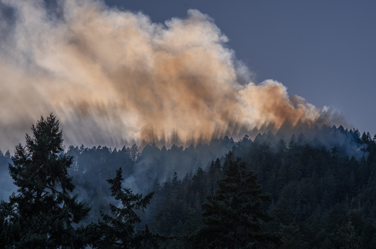
Flat Fire and Anvil Fire Morning Update 09072023
Related Incident: Flat FireAnvil Fire
Publication Type: News
A community meeting will be held tonight for the Anvil Fire at 6:00 p.m. at The Grange (44556 Highway 101) in Sixes. It will also be broadcast Live on the Flat and Anvil Fires Facebook page: https://www.facebook.com/flatfireoregon2023
Flat Fire Activity
Size: 34,242 acres Start Date: July 15, 2023 Point of origin: 2 miles southeast of Agness, OR
Containment: 70% Total personnel: 325
Resources: 6 crews, 3 helicopters, 12 engines, 7 water tenders, 10 pieces of heavy equipment
Fire crews continue to work with resource advisors to repair impacts to the landscape caused by suppression efforts.
This includes installing water bars, seeding and mulching to prevent erosion. Other suppression repair activities may include reducing berms created by heavy equipment with excavators and hand crews and chipping branches and small trees. A Burned Area Emergency Response (BAER) team arrived yesterday. This team will determine the need for emergency treatments to minimize threats to life or property resulting from the effects of the fire. They are also tasked to stabilize and prevent degradation of the natural and cultural resources because of the fire. Visit https://bit.ly/44H7nRe for more information on the BAER program. While fire activity remains minimal, interior pockets of vegetation will continue to burn and show smoke. Initial Attack resources are staged and ready to assist the Forest if needed.
Anvil Fire Activity
Size: 313 acres Start Date: August 25, 2023 Point of origin: 8 miles east of Port Orford, OR
Containment: 0% Total personnel: 152
Resources: 4 crews, 3 helicopters, 4 engines, 4 water tenders, 2 pieces of heavy equipment
The objective of the Anvil Fire is to keep it as small as possible. Fire managers are planning and implementing strategies to fight the fire as close to its edge as feasible and safe. Yesterday, air resources were used on the west side to slow the fire’s spread. Four single-engine air tankers (SEATs) and one large air tanker (LAT) dropped water on the fire, along with four helicopters, totaling 108,540 gallons of water. Two Wildland Fire Modules are camped near the fire to monitor fire behavior and construct lines along the western and northwestern edges. Firefighters continue to improve the Grassy Knob Road, removing vegetation in case it needs to be used as a control line. Additionally, crews are clearing hazardous fuels along Elk River Road. Two structure protection groups were established to work at residences along Elk River Road and Sixes River Road. Fire managers continue to formulate alternative plans for lines further from the fire if they are needed.
Weather: Temperatures remain warmer, and humidity levels drier. However, a weak cold front may bring slightly cooler temperatures and higher relative humidities in the afternoon, particularly in the Anvil Fire area.
Smoke: Visit https://fire.airnow.gov/ for the national wildfire smoke map.
Closures: U.S. Highway 199 has been reopened to all traffic using a pilot car system north of Gasquet to the Oregon border in California. Local law enforcement cautions against any non-essential traffic along this route. Expect 20-40 minute delays. The Rogue River-Siskiyou National Forest (RRSNF) has issued closure orders in the areas of the Flat and Anvil fires. For more information, visit https://bit.ly/RRSNFAlerts
Evacuations: Level 1 “Get Ready” evacuation status is in place for areas near the Flat Fire. Level 2 “Get Set“ evacuation status is in place along the Elk River from about milepost 4 to the USFS Butler Bar Campground near the Anvil Fire. Sign up for Curry Co. Everbridge Notifications (emergency alerts) at https://bit.ly/CurryCoEM to receive evacuation alerts.
Restrictions: The Rogue River-Siskiyou National Forest is decreasing the fire danger from Extreme down to High and the Industrial Fire Precaution Level from Level 3 to Level 2, effective September 5, 2023. Public Use Restrictions (PUR) remain at Stage 3 across the forest and on the Wild Section of the Rogue National Wild and Scenic River. Visit https://bit.ly/RRSNFAlerts for more information. There is a Temporary Flight Restriction (TFR) over the fire areas. Please do not fly unmanned aircraft (drones) in the fire vicinity. If you fly, we can't.
Tiger Island Fire Smoke Report 9723
Related Incident: Tiger Island Fire
Publication Type: News
Special Statement
Learn the air quality index numbers and colors: During periods of poor air quality, watch for air quality alerts, pay attention to numbers and colors of air quality monitors, and know when to limit your time outdoors. EPA Smoke Sense is an app that allows you to check current conditions on iPhone and Android. • fire.airnow.gov is a great website that provides even more local information.
Fire
The four fires in the area are Tiger Island (31,882 ac); Elizabeth (940 ac); Hwy. 113 (7,709 ac) and Lions Camp Rd. (785 ac). Moderate potential for fire activity today as fuels continue to dry after recent rains. (visit Inciweb Tiger Island Fire for more details) (visit Inciweb Hwy 113 Fire for more details) (visit Inciweb Elizabeth Fire for more details) (visit Inciweb Lions Camp Road Fire for more details) Smoke
Light smoke in the vicinity of large fuels that continue to smolder. Heat scorched leaves and pine needles have fallen and covered some of the burned areas. Those areas have an increased potential for reburn as fuels dry. Reburn would cause higher levels of smoke in localized areas. Expect to see only light smoke in the immediate vicinity of a fire or on interior roads. None of the communities in the area should be impacted by smoke from the fires. Monitor locations may have more smoke today due to drying fuels and increased
smoldering of large fuels. Even with the increased smoldering, communities should experience GOOD air
quality. DeRidder, Lake Charles and Lafayette may have brief periods of MODERATE air quality with smoke from other sources.
Hwy 113 Smoke Report 090723
Related Incident:
Publication Type: News
Special Statement
Learn the air quality index numbers and colors: During
periods of poor air quality, watch for air quality alerts, pay attention to numbers and colors of air quality monitors, and know when to limit your time outdoors. EPA Smoke Sense is an app that allows you to check current conditions on
iPhone and Android. • fire.airnow.gov is a great website that provides even more local information.
Fire
The four fires in the area are Tiger Island (31,882 ac); Elizabeth (940 ac); Hwy. 113 (7,709 ac) and Lions Camp Rd.(785 ac). Moderate potential for fire activity today as fuels continue to dry after recent rains. (visit Inciweb Tiger Island Fire for more details) (visit Inciweb Hwy 113 Fire for more details) (visit Inciweb Elizabeth Fire for more details) (visit Inciweb Lions Camp Road Fire for more details)
Smoke
Light smoke in the vicinity of large fuels that continue to smolder. Heat scorched leaves and pine needles have fallen and covered some of the burned areas. Those areas have an increased potential for reburn as fuels dry. Reburn would cause higher levels of smoke in localized areas. Expect to see only light smoke in the immediate vicinity of a fire or on interior roads. None of the communities in the area should be impacted by smoke from the fires. Monitor locations may have more smoke today due to drying fuels and increased smoldering of large fuels. Even with the increased smoldering, communities should experience GOOD air quality. DeRidder, Lake Charles and Lafayette may have brief periods of MODERATE air quality with smoke from other sources.
Lions Camp Road Fire Smoke Update 09723
Related Incident: Lions Camp Road Fire
Publication Type: News
Special Statement
Learn the air quality index numbers and colors: During
periods of poor air quality, watch for air quality alerts, pay attention to numbers and colors of air quality monitors, and know when to limit your time outdoors. EPA Smoke Sense is an app that allows you to check current conditions on
iPhone and Android. • fire.airnow.gov is a great website that provides even more local information.
Fire
The four fires in the area are Tiger Island (31,882 ac); Elizabeth (940 ac); Hwy. 113 (7,709 ac) and Lions Camp Rd.(785 ac). Moderate potential for fire activity today as fuels continue to dry after recent rains. (visit Inciweb Tiger Island Fire for more details) (visit Inciweb Hwy 113 Fire for more details) (visit Inciweb Elizabeth Fire for more details) (visit Inciweb Lions Camp Road Fire for more details)
Smoke
Light smoke in the vicinity of large fuels that continue to smolder. Heat scorched leaves and pine needles have fallen and covered some of the burned areas. Those areas have an increased potential for reburn as fuels dry. Reburn would cause higher levels of smoke in localized areas. Expect to see only light smoke in the immediate vicinity of a fire or on interior roads. None of the communities in the area should be impacted by smoke from the fires. Monitor locations may have more smoke today due to drying fuels and increased smoldering of large fuels. Even with the increased smoldering, communities should experience GOOD air quality. DeRidder, Lake Charles and Lafayette may have brief periods of MODERATE air quality with smoke from other sources.
Tyee Ridge Complex Evening Update 090623
Related Incident: Tyee Ridge Complex
Publication Type: Announcement
Acreage: 7,445
Containment: 38%
Good Progress Made on All Fires Within the Complex
UMPQUA, Ore. – In multiple areas of the Complex, fire crews took advantage of the previous work on the fire’s perimeter lines. With today’s favorable sunny and drier weather the crews engaged in planned tactical firing operations. These actions provided a clean, well-controlled, slow backing fire which cleaned up pockets of unburned fuels in otherwise difficult to access areas. This work will continue into tomorrow, weather conditions permitting.
Crews mopped up 50 to 100 feet in from the fire perimeter on the Lighthouse Fire and strengthened those lines. Tyee Mountain Fire was inspected and remains in patrol status. Work on the Big Tom Fire consisted of removal of dead standing and fire-weakened hazard trees (snags). Heavy mop up 120 to 200 feet in from the fire perimeter continued. On the Cougar Creek Fire, crews continued tactical burn operations along Hubbard Creek Road and Briarwood Road, and made good progress cleaning out hard to reach fuels in challenging terrain. Where the fire has had minimal recent movement, crews engaged in “tight-lining” or going direct by constructing containment lines at the edge of the fire. On the western edge of the fire, preparation for future tactical firing operations continued along with tight-lining where possible.
Incident Meteorologist Andrew Gorelow stated “Expected weather this evening will bring 90% to 100% relative humidity as a deep marine layer of moisture pushes in with morning fog tomorrow resulting in decreasing fire behavior.”
Level 2 (Be Set) and Level 1 (Be Prepared) evacuation notices are still in effect. To view the current evacuation information map, go to www.dcso.com/evacuations. To shelter livestock, contact Douglas County Animal Control at 541-440-4471. Companion pets can be sheltered at Saving Grace Pet Adoption Center in Roseburg.
Due to decreasing fire activity and strong fire suppression work, this will be the last evening update.
Oregon Department of Forestry Team 1
Joe Hessel, Incident Commander