
Settings - change map background and toggle additional layers
Filter - control incident types displayed on map.
Zoom to your location
Reset map zoom and position
Could not determine your location.
Show Legend
 Wildfire
 Prescribed Fire
 Burned Area
Response
Burned Area
Response Other
Other
Eagle Point Fire
Unit Information
Incident Contacts
Update Chilcoot and Ridge Fires September 3 2023
Related Incident: 2023 Chilcoot Fire UNF2023 Ridge Fire UNF
Publication Type: News
CHILCOOT AND RIDGE FIRE UPDATE
Sunday, September 3, 2023
Chilcoot Fire: Size: – 1,762 acres, Containment:4%
Ridge Fire: Size – 238 acres, Containment:45%
Scattered showers and thunderstorms occurred in and around the fire area Saturday, minimizing fire activity. Creeping and smoldering was observed with concentrations of dead and downed fuels remaining active. One helicopter was utilized to drop buckets on areas of heat. Last night an infrared (IR) flight was utilized to secure an accurate map of the fire and detect heat spots. Firefighters will continue to push forward, building and securing containment lines.
Chilcoot Fire - On the west flank of the fire, crews continued to mop up along road and dozer lines. Firefighters are working aggressively to secure the fire's edge from the southwest corner of the Hipower Creek towards the 3803 road. In the northeast corner of the fire, crews secured hand-lines and progressed to the west in effort to minimize the fire footprint. Equipment will continue to be utilized by opening and improving the 3806 road south to the 38 road. Firefighters continue to work together in order to go direct on the fire line to build and secure containment lines.
Ridge Fire - Firefighters are working directly along the fire's edge to establish and secure containment lines. Resources will be shifted to the Chilcoot fire as the containment line becomes firm.
Weather - A slight cooling trend continues, with higher relative humidity, likely leading to minimally active fire behavior. Passage of surface or upper level low pressure systems of precipitation are expected through Monday night. The rest of the week's forecast shows dry conditions, with near normal temperatures in the mid-70's.
Evacuations
No current evacuations.
Closures
- Closure Order (06-15-00-23-475) in the Umpqua NF has been established. The order is effective from Aug 28, 2023 – Dec 1, 2023. For full order go to Umpqua National Forest - Alerts & Notices (usda.gov)
- A Closure Order for the Canton Creek area has been issued by Bureau of Land Management (BLM) Chilcoot Ridge Fire EMERGENCY CLOSURE ORDER BLM Roseburg District
- Temporary Flight Restrictions can be found at https://tfr.faa.gov/tfr2/list.jsp
Additional information
- Facebook: https://www.facebook.com/profile.php?id=61550481586772
- Twitter: https://twitter.com/UmpquaNF
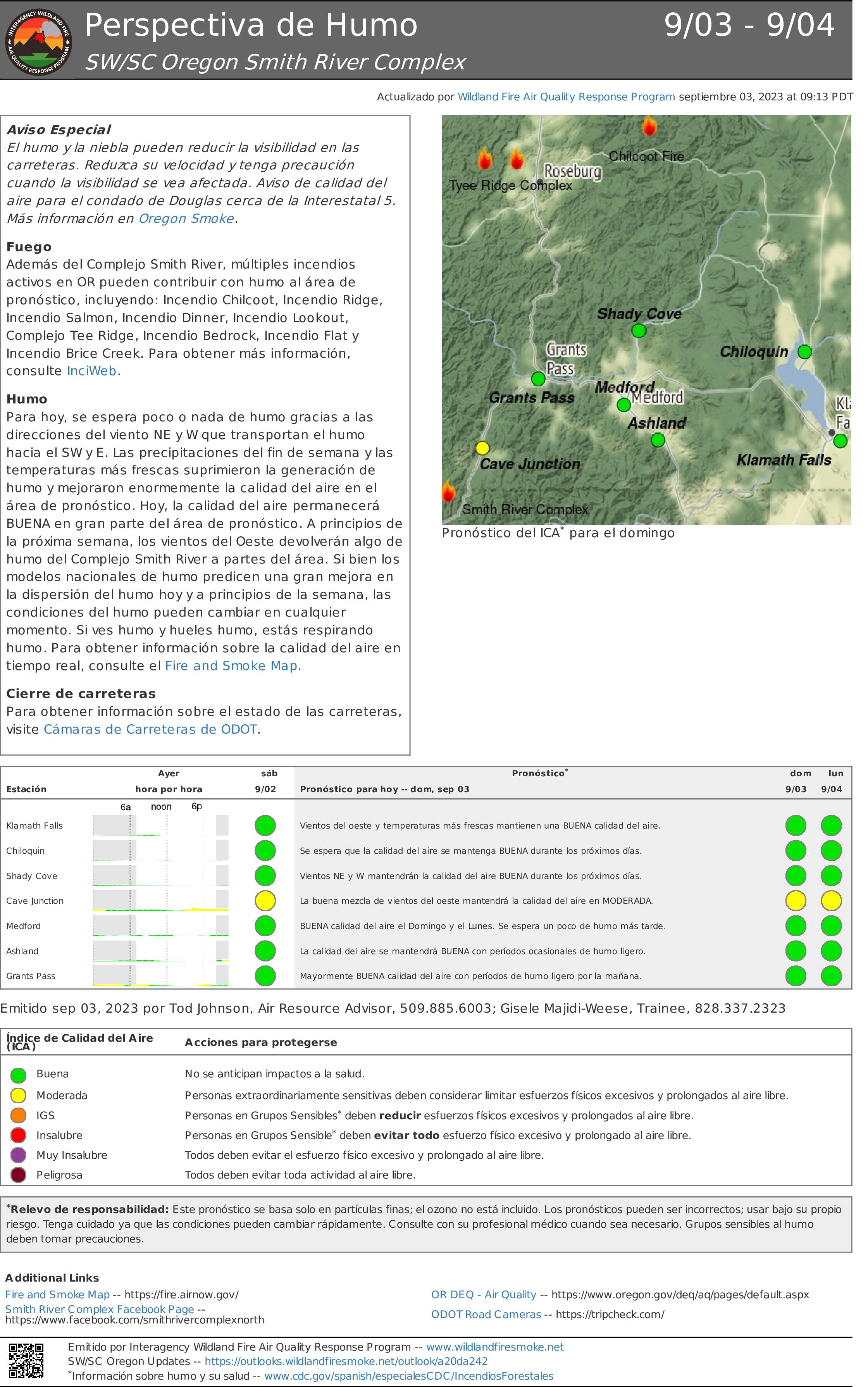
Perspectiva de Humo Smith River Complex North 903 904
Related Incident: Smith River Complex
Publication Type: News
Aviso Especial
El humo y la niebla pueden reducir la visibilidad en las carreteras. Reduzca su velocidad y tenga precaución cuando la visibilidad se vea afectada. Aviso de calidad del aire para el condado de Douglas cerca de la Interestatal 5. Más información en Oregon Smoke.
Fuego
Además del Complejo Smith River, múltiples incendios activos en OR pueden contribuir con humo al área de pronóstico, incluyendo: Incendio Chilcoot, Incendio Ridge, Incendio Salmon, Incendio Dinner, Incendio Lookout, Complejo Tee Ridge, Incendio Bedrock, Incendio Flat y Incendio Brice Creek. Para obtener más información, consulte InciWeb.
Humo
Para hoy, se espera poco o nada de humo gracias a las direcciones del viento NE y W que transportan el humo hacia el SW y E. Las precipitaciones del fin de semana y las temperaturas más frescas suprimieron la generación de humo y mejoraron enormemente la calidad del aire en el área de pronóstico. Hoy, la calidad del aire permanecerá BUENA en gran parte del área de pronóstico. A principios de la próxima semana, los vientos del Oeste devolverán algo de humo del Complejo Smith River a partes del área. Si bien los modelos nacionales de humo predicen una gran mejora en la dispersión del humo hoy y a principios de la semana, las condiciones del humo pueden cambiar en cualquier momento. Si ves humo y hueles humo, estás respirando humo. Para obtener información sobre la calidad del aire en tiempo real, consulte el Fire and Smoke Map.
Cierre de carreteras
Para obtener información sobre el estado de las carreteras, visite Cámaras de Carreteras de Oregon Department of Transportation.
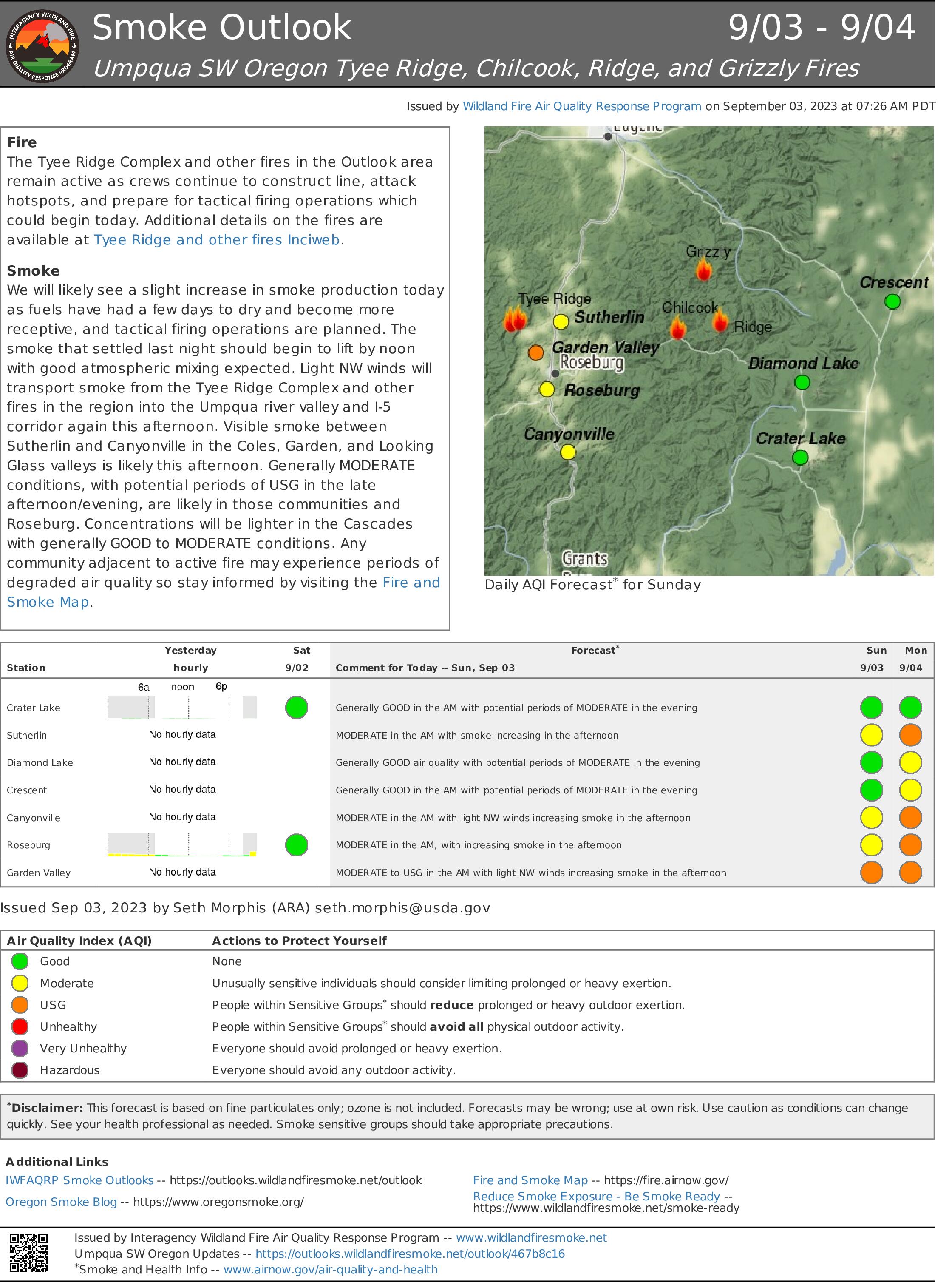
Tyee Ridge Complex Morning Update 090323
Related Incident: Tyee Ridge Complex
Publication Type: Announcement
Size: 6,674 acres
Contención: 21%
Las cuadrillas preparan operaciones de quema en el Tyee Ridge Complex
UMPQUA, Oregon. – Los equipos de bomberos del turno de noche aprovecharon la buena recuperación de humedad para lograr un buen avance en el cortafuego. Las cuadrillas extinguieron las líneas de contención y conectaron y construyeron líneas de control y contingencia para las próximas operaciones de quema táctica.
Hoy, los equipos del Departamento forestal de Oregón continuarán la construcción de líneas para operaciones de quema táctica. Dado que ciertas áreas están demasiado empinadas y peligrosas para que los bomberos coloquen una línea de mano, la línea indirecta se construye en un lugar más seguro. Ya se quemó el área entre esa línea y el fuego. Esta estrategia es una forma muy efectiva de "combatir el fuego con fuego" y planificar la propagación del fuego. La quema táctica ocurrirá en un área pequeña donde los equipos no pueden acceder en la parte este del incendio. Se trasladaron equipos de bomberos adicionales para ayudar con la quema táctica. La quemadura táctica se moverá hacia el NE a lo largo de los bordes de fuego no contenidos. Esta actividad aumentará el humo sobre el fuego hoy. Los recursos aéreos volarán hoy, continuarán monitoreando cualquier incendio salpicado que pueda ocurrir, vaciando agua y apoyando a los bomberos en la línea al dejar caer retardante.
Las condiciones climáticas de hoy traerán neblina ligera por la mañana que se despejará por la tarde. No se esperan tormentas eléctricas ni lluvia hoy, pero los cielos estarán parcialmente nublados. Se espera que disminuya la humedad del combustible. Esto resultará en que el fuego ardiente y rastrero actual se ponga más activo por la tarde.
Ya que el clima favorable a principios de esta semana minimizó las amenazas a las estructuras, los recursos del Jefe de bomberos del estado de Oregón, incluido el Equipo de Manejo de Incidentes Rojos, regresarán a sus agencias de origen hoy. La delegación será devuelta a las autoridades locales para responder al fuego. Si surge la necesidad de protección estructural, se puede pedir que regresen. OSFM agradece a la comunidad por su apoyo.
Para ver el mapa de información de evacuación actual, vaya a www.dcso.com/evacuations. Para albergar ganado, comuníquese con el Control de animales del condado de Douglas al 541-440-4471. Las mascotas de compañía pueden ser refugiadas en el centro de adopción de mascotas Saving Grace en Roseburg.
Equipo 1 del Departamento Forestal de Oregón
Joe Hessel, Comandante del incidente
Equipo Rojo de OSFM, Ian Yocum, Comandante de incidentes
Tyee Ridge Complex Smoke Outlook 09022023
Related Incident: Tyee Ridge Complex
Publication Type: News
Tyee Ridge Complex Smoke Outlook 09022023
Related Incident: Tyee Ridge Complex
Publication Type: News
Tyee Ridge Complex Smoke Outlook 09012023
Related Incident: Tyee Ridge Complex
Publication Type: News
Ridge Creek Fire Daily Update September 3 2023
Related Incident:
Publication Type: News
Location: Approximately 3.5 miles east of the north tip of Hayden Lake, along the Hayden Creek Road (Forest Service Road 437) from the Ridge Creek drainage to South Chilco Mountain.
Start Date: 8/3/2023 Cause: Human-caused Size: 4,474 acres Containment: 51%
Total Personnel: 183 Heavy Equipment: 5 Crews: 1
This is the last update from the Southern Area Gold Team. At 6:00 pm today, the Gold Team will transfer command of the fire to a smaller, local team. Thank you for supporting the Gold Team in managing this fire. We’ve enjoyed serving you and wish the incoming team a good and safe assignment.
All fire restrictions have been lifted for the Idaho Panhandle National Forest. While campfires are no longer restricted, hunters and recreationists are urged to continue to use caution. Never leave a campfire unattended, and make sure it is cold to the touch before walking away. Please visit https://www.idl.idaho.gov/fire-management/fire-restrictions-finder for a detailed map and current information regarding fire restrictions across the state.
With weekend traffic, motorists are advised to watch for firefighting equipment as firefighters released from the incident travel home.
FIRE STATUS
The Ridge Creek Fire was reported on 8/3/23 at 2:30 pm in the Ridge Creek drainage, approximately three miles east of the northern tip of Hayden Lake. Investigators have determined that the fire was human caused.
Yesterday, firefighters continued to monitor and patrol the fire's edge, mop up hot spots, chip along roads and make repairs to roads, bulldozer and hand lines and other features damaged by fire suppression. They monitored an isolated hot spot producing smoke within the fire near South Chilco Mountain, which posed no threat to further spread. All engines and crews demobilized from the fire except for an initial attack crew ready to respond to new fires. Excavators, chippers, graders and dump trucks worked to repair bulldozer lines and roads. Specific areas of work included grading on the 206 Road from Bumblebee Campground to Burnt Cabin Cree, excavator work on the 406M Road, chipped work on the 625 and Bunco Roads, and dump truck and front-end loader work to repair potholes on the 437 Road.
Today this work will continue as Operations overhead from a local Type 3 management team shadows Southern Area Gold Team Operations in preparation for transfer of command this evening.
WEATHER AND FIRE BEHAVIOR
High temperatures will drop into the 60s today accompanied by breezy winds and the chance of showers. Starting Tuesday, a gradual warming and drying trend will set in, and this pattern will continue throughout the week. Each day expect afternoon winds to increase, particularly on ridges, but they should not reach levels of concern. The strongest winds of the forecast will be Wednesday with gusts to 19 mph.
High temperatures today are expected to be around 65 degrees with southwest winds 5-6 mph. Minimum relative humidity is expected to be around 55 percent.
Air quality information is available at www.airnow.gov and www.wildlandfiresmoke.net.
Live and dead vegetation remains damp from recent rainfall and active flames are unlikely. With a drying trend, some areas of smoke may appear where built-up organic material or large logs smolder, especially in areas with remaining heat at the northeast portion of the fire. Notable fire spread is not expected during the next five days.
CLOSURES AND SPECIAL MESSAGES
Kootenai County has lifted all evacuation notices. Please monitor official county sources for the most up-to-date information. https://www.kcsheriff.com/186/Emergency-Management
A daylight hours temporary flight restriction remains in place today, but will be lifted this evening at 7:00 pm. Information is available at https://tfr.faa.gov/save_pages/detail_3_3347.html
Closure Order #01-04-03-23-003 for the Idaho Panhandle National Forest remains in place for Forest Service land north of Forest Service Road (FSR) 206, west of FSR 209 and FSR 385, and south of FSR 332; and for Forest Service land surrounding and north of the Yellowbanks Creek area and west of FSR 1535.
The closure includes all Forest Service Roads within the area:
- FSR 332, 385, 392, 428A, 437, 1507, 1511, 1530, 1552 and 1587.
- FSR 206 north of the junction with FSR 406.
- FSR 406 north of the junction with FSR 206.
- Bunco Road/FSR 332 from the National Forest boundary east to the junction of FSR 385.
- FSR 385 from the junction with Bunco Road/FSR 332 south to the junction of FSR 209 and FSR 794.
It also includes Forest Service Trails 69, 78, 234, 577 and 802.
This order is necessary for public and firefighter safety due to heavy fire traffic and equipment in the area. For more information, please see the Idaho Panhandle National Forest website at Idaho Panhandle National Forests - Alerts & Notices (usda.gov)
-END-
Tyee Ridge Complex Smoke Outlook 08302023
Related Incident: Tyee Ridge Complex
Publication Type: News
Informacin al da para el Incendio Smith River Complex South sbado3 de septiembre 2023
Related Incident: Smith River Complex
Publication Type: News
Fecha de inicio: 15 de agosto de 2023
Ubicación: Bosque Nacional Six Rivers
Causa: Relampagos
Acres: 84,802
Contención: 12%
Personal: 2,969
Reflejos: US-199 se abrió a todo el tráfico el sábado 2 de septiembre de 2023. Caltrans y CHP están dirigiendo el tráfico entre Patrick Creek y Oregon Mountain Road. El personal de bomberos, Caltrans y los equipos de construcción están trabajando activamente a lo largo de la carretera; Continúe teniendo precaución y conduciendo lentamente. Tenga en cuenta que las operaciones contra incendios están en curso, el Smith River Complex está activo y las condiciones podrían cambiar.
La Oficina del Sheriff del Condado de Del Norte, en colaboración con la Oficina de Servicios de Emergencia del Condado de Del Norte, redujo el nivel de evacuación en el Área de Oregon Mountain Road y la Zona de Evacuación Sun Star al Nivel 2. La repoblación de estas comunidades comenzó el 2 de septiembre.Un Mapa de evacuacion Interactiva está disponible para mantener a los residentes informados sobre los Niveles de evacuación actuales.
Operaciones: Se espera que el comportamiento del fuego aumente gradualmente en escala, duración e intensidad durante los próximos días. Se espera que el potencial de crecimiento más activo esté en el incendio Coon, ya que cierra la brecha con Forest Road 405 y a lo largo de Bear Basin Road para el incendio Kelly. Se espera que el incendio Hurdy Gurdy continúe avanzando hacia Bear Basin Road, continúe flanqueando hacia el oeste a lo largo de Fox Ridge Road y continúe retrocediendo lentamente cuesta abajo hacia el este hacia el río Smith.
Clima: El sábado por la noche cayeron precipitaciones mínimas sobre la zona del incendio. El domingo comenzará una tendencia al calentamiento y la sequía. La actividad de los incendios aumentará gradualmente, pero no se prevé un crecimiento significativo.
Humo: Espere humo donde el fuego se ha trasladado a las cicatrices de incendios forestales anteriores: Biscuit (2002), Bear and Coon (2015), Eclipse (2017) y Slater (2020). La información sobre la calidad del aire está disponible en https://www.airnow.gov/
Seguridad: La Oficina del Sheriff de Del Norte pide a los residentes que se abstengan de realizar viajes innecesarios. Las carreteras locales estarán muy activas con bomberos y aparatos contraincendios, especialmente entre las 6:30 y las 8:30 horas.
Restricciones/Cierres: Los cierres se ajustarán según la actividad del incendio. Todas las carreteras del condado dentro del área cerrada permanecen cerradas y están patrulladas por las autoridades.
Evacuaciones: Las órdenes de evacuación las emite la Oficina del Sheriff del condado de Del Norte. Si se encuentra en el área del condado de Del Norte, regístrese en su Sistema de alerta comunitaria para recibir notificaciones de emergencia. Las evacuaciones actuales están en línea : Mapa de evacuacion Interactiva
NIVEL 3 “Vaya ahora”: Rockland
NIVEL 2 “Prepárese”: Gasquet, Rowdy Creek/Low Divide, Big Flat/Rock Creek, Patrick Creek, Patrick Creek Lodge, Little Jones/Washington Flat Área residencial.
NIVEL 1 “Esté preparado”: Hiouchi
Información sobre incendios: 2023.smithrivercomplex@firenet.gov
Facebook: https://www.facebook.com/SixRiversNF