
Hwy 113 Fire Smoke Report 9323
Related Incident:
Publication Type: News
Special Statement
Visibility can be reduced in areas with both smoke and fog. Exercise caution if driving in these conditions. The Hwy. 113 and Hwy. 10 crossings of Ten Mile Creek are where this is most likely.
Fire
The four fires in the area are Tiger Island (31,342 ac); Elizabeth (943 ac); Hwy. 113 (7,321 ac) and Lions Camp Rd.(790 ac). The potential for increased fire activity is much diminished today. (visit Inciweb Tiger Island Fire for more details) (visit Inciweb Hwy 113 Fire for more details) (visit Inciweb Elizabeth Fire for more details) (visit Inciweb Lions Camp Road Fire for more details)
Smoke
Local smoke continues near fires and on roads adjacent to them. If there is active fire behavior or new starts, there could be high levels of smoke for short durations near fires. There is a chance for thunderstorms with gusty and erratic winds that could move smoke in any direction. Smoke from the Tiger Island Fire will be most apparent in the Merryville and Junction areas. Smoke from the Elizabeth and Hwy. 113 fires will be most noticeable in the Cora area and Hwy. 113 between the two fires. There was very little smoke from the Lions Camp Rd Fire yesterday. Light smoke may occur today on roads within the fire perimeter. All four fires are projected to produce low levels of smoke. All smoke monitors, except Lake Charles, should see less smoke today. These locations will have GOOD levels with periods of MODERATE. Lake Charles should expect smoke from fires SE and SW of town. Expect mostly MODERATE, with periods of GOOD.
Tiger Island Fire Smoke Report 9323
Related Incident: Tiger Island Fire
Publication Type: News
Special Statement
Visibility can be reduced in areas with both smoke and fog. Exercise caution if driving in these conditions. The Hwy. 113 and Hwy. 10 crossings of Ten Mile Creek are where this is most likely.
Fire
The four fires in the area are Tiger Island (31,342 ac); Elizabeth (943 ac); Hwy. 113 (7,321 ac) and Lions Camp Rd.(790 ac). The potential for increased fire activity is much diminished today. (visit Inciweb Tiger Island Fire for more details) (visit Inciweb Hwy 113 Fire for more details) (visit Inciweb Elizabeth Fire for more details) (visit Inciweb Lions Camp Road Fire for more details)
Smoke
Local smoke continues near fires and on roads adjacent to them. If there is active fire behavior or new starts, there could be high levels of smoke for short durations near fires. There is a chance for thunderstorms with gusty and erratic winds that could move smoke in any direction. Smoke from the Tiger Island Fire will be most apparent in the Merryville and Junction areas. Smoke from the Elizabeth and Hwy. 113 fires will be most noticeable in the Cora area and Hwy. 113 between the two fires. There was very little smoke from the Lions Camp Rd Fire yesterday. Light smoke may occur today on roads within the fire perimeter. All four fires are projected to produce low levels of smoke. All smoke monitors, except Lake Charles, should see less smoke today. These locations will have GOOD levels with periods of MODERATE. Lake Charles should expect smoke from fires SE and SW of town. Expect mostly MODERATE, with periods of GOOD.
Tyee Ridge Complex Evening Update 090223
Related Incident: Tyee Ridge Complex
Publication Type: Announcement
Acreage: 6,674
Containment: 21%
Containment Grows on Tyee Ridge Complex
Umpqua, Ore.– The Tyee Ridge Complex showed minimal growth today. This evening firefighters are preparing for thunderstorms and variable weather conditions. Tonight’s focus continues to be mopping up containment lines and preparing contingency lines for future firing operations. Evacuation levels remain unchanged, and roads remain closed in the Hubbard Creek area and residents can return to their homes with proof of residency.
Today, Oregon Department of Forestry crews continued to fight fire more directly with the favorable weather conditions. Along uncontrolled areas of Cougar Creek fire, firefighters are constructing tethered dozer and handline to connect control and contingency lines for future tactical firing operations. The Oregon State Fire Marshal task forces continued to patrol and mop up around structures. Two task forces were demobilized today with the diminished threat to structures, however if anything changes, OSFM resources will be readily available.
Helicopter resources remained busy making bucket drops on the active parts of the fire. This afternoon, aircraft detected a spot fire on the NW portion of the Cougar Creek Fire which was quickly contained. The Tyee Ridge Complex remains active, and spotting remains a possibility. Crews have been quick to identify and extinguish new spot fires.
An afternoon thunderstorm brought strong winds, hail, and brief heavy rains on the SW side of the Cougar Creek Fire. More thunderstorms are forecasted for later this evening that may bring heavy rain and additional lightning. Additional engines will be ready for initial attack if lightning creates any new starts.
To view the current evacuation information map, go to www.dcso.com/evacuations. The Red Cross shelter closed today at 12 PM. To shelter livestock, contact Douglas County Animal Control at 541-440-4471. Companion pets can be sheltered at Saving Grace Pet Adoption Center in Roseburg.
Oregon Department of Forestry Team 1
Joe Hessel, Incident Commander
OSFM Red Team, Ian Yocum, Incident Commander
Cowlitz Complex Public Information Trapline Locations
Related Incident: Cowlitz Complex
Publication Type: Announcement
Fire info for the Cowlitz Complex is available out in the community! Check out the "trapline" locations at
Google Map and stop by!
These "trapline stops" are provided printed fire information that is updated daily!
Happy Camp Complex Incident Update September 2 2023 Evening
Related Incident: 2023 Happy Camp Complex Klamath NF
Publication Type: News
HORSE CREEK COMMUNITY MEETING: A community meeting and fire operations update will be taking place Sunday, September 3rd, at 5:30 p.m. at Klamath River Elementary School, located at 30438 Walker Road, Horse Creek, CA 96050.
WEATHER: Firefighters experienced cooler temperatures and light rain on the Happy Camp Complex today. A flash flood watch issued by the National Weather Service is in effect until 11 p.m. tonight for the McKinney (2022) and Head fire burn areas.
WEST SIDE OVERVIEW (ACRES/CONTAINMENT): Elliot (11,723 acres, 51%), Ufish (4,849 acres, 9%) Hancock (1,653 acres, 0%)
Today, firefighters on the Elliot Fire scouted locations to build additional fire line on the west side of fire. The fire is holding at Dillon Creek and State Route 96. Crews on the Ufish will continue to improve fire lines for potential future strategic firing operations. Tonight, fire crews will patrol and mop up dozer and hand line to remove any heat discovered.
Clear skies allowed for an aerial reconnaissance flight over the Hancock Fire to assess fire growth and activity. Due to the steep and rugged terrain, smokejumpers will fly into Creek Camp to evaluate the area and values at risk. The Hancock Fire is located in the Marble Mountain Wilderness near Bear Skull Camp, northwest of Hancock Lake.
EAST SIDE OVERVIEW (ACRES/CONTAINMENT): Head (6,940 acres, 91%), Block (0.1 acres, 100%), Townsend (81 acres, 100%), Den (294 acres, 100%), Scott (1,886 acres, 89%), Lake (199, acres, 100%)
Crews on the Head Fire continued to secure fire line on the last remaining section of the fire. Suppression repair work will be ongoing. The Scott Fire had minimal fire activity today. As of this afternoon, CAL FIRE is no longer in unified command on the Happy Camp Complex. The CAL FIRE Siskiyou Unit provided support on the Scott Fire. The Lake Fire was declared 100 percent contained last night.
Incident Commander Dustan Mueller would like to thank CAL FIRE Incident Commander Greg Roath, and the CAL FIRE Siskiyou Unit, for their hard work and commitment while protecting the communities affected by the Happy Camp Complex.
EVACUATIONS: View current Siskiyou County evacuation orders and warnings by visiting: community.zonehaven.com. Siskiyou County residents are encouraged to sign up for rapid emergency notifications using the CodeRED emergency alert system at: www.co.siskiyou.ca.us/emergencyservices/page/codered-emergency-alert
ROAD CONDITIONS: No road work will be performed on State Route 96 through Wednesday, September 6th, at 7 a.m., to allow for holiday travel. Please keep in mind that one-way traffic control will remain in place from 2.8 miles west of Dillon Road to 8.8 miles east of Dillion Road, as this remains in an active fire area for the Elliot Fire. Motorists can expect up to 30-minute delays in this area. County road closures will be listed on the Siskiyou County Public Works website: www.co.siskiyou.ca.us/publicworks/page/closures-and-delays
FOREST CLOSURES: Two closure orders have been implemented: Happy Camp Complex Emergency Fire Closure No. 05-05-23-06 and No. 05-05-23-08. Additionally, fire restrictions remain in place to help minimize the chances of human-caused wildland fires. These restrictions prohibit campfires outside of designated improved recreation areas and wilderness. View closure orders, fire restrictions, and maps at: www.fs.usda.gov/alerts/klamath/alerts-notices
TEMPORARY FLIGHT RESTRICTION (TFR): A TFR has been established over the fire area. Flight restrictions include the use of drones. The operation of drones under the TFR is prohibited.
PACIFIC CREST TRAIL: The Pacific Crest Trail is now open between the Shelly Fork Junction and Seiad.
AIR QUALITY: For information regarding smoke impacts and what you can do to protect yourself, visit the Siskiyou County Air Pollution Control District Fire and Smoke Information website at: www.co.siskiyou.ca.us/airpollution/page/fire-and-smoke-information or AirNow.gov
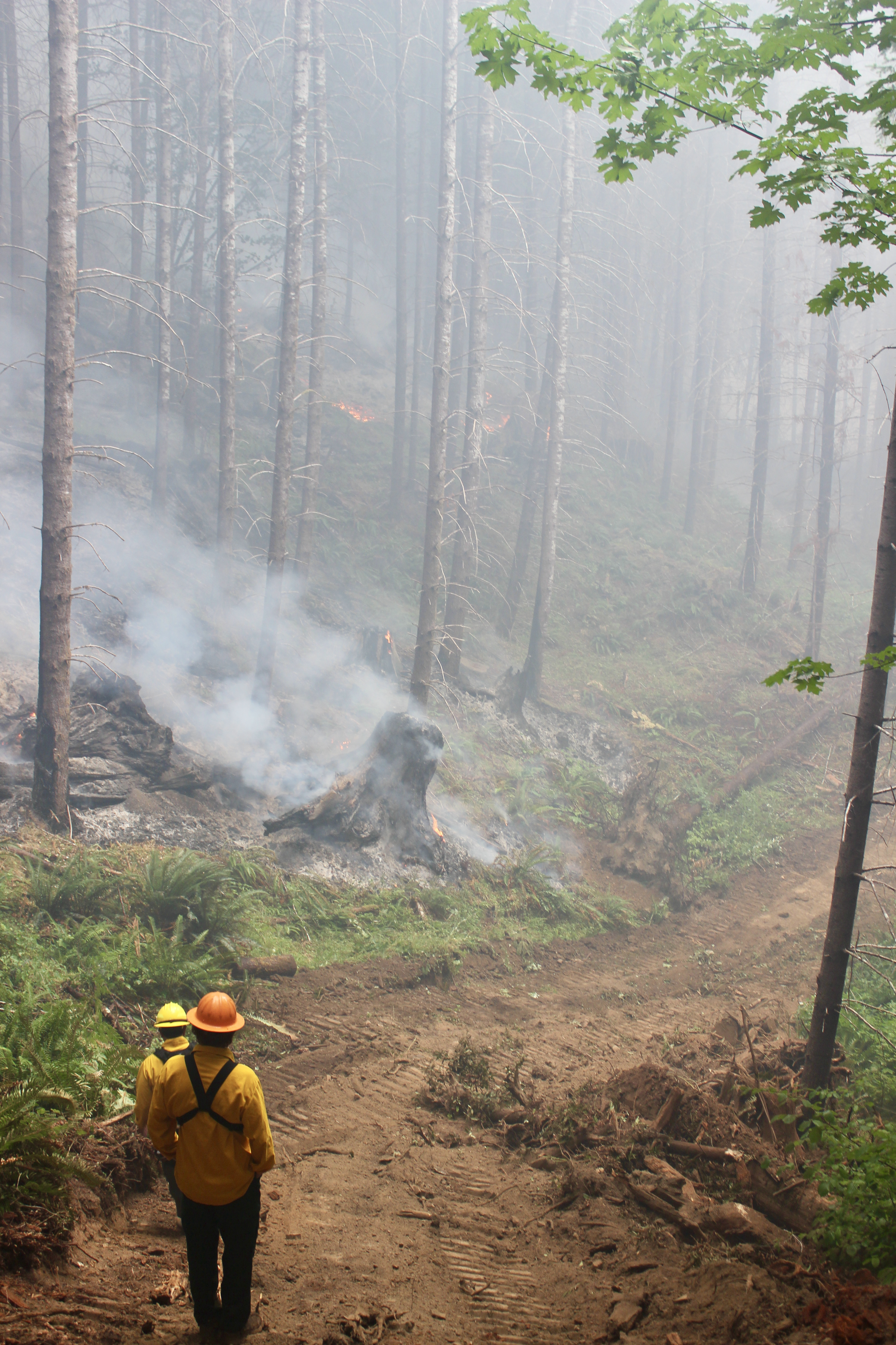
Additional Great Basin Team 1 Photos and Videos
Related Incident: Camp Creek Fire
Publication Type: Announcement
Our Inciweb site includes a Photographs Gallery that includes a selection of images from the Camp Creek Fire. The Videos Gallery limits the size of videos we can post, so it remains empty. However, the visual resources we share aren't limited to Inciweb alone. Great Basin National Incident Management Team #1 is sharing photos and videos on their YouTube and Flickr accounts:
- Great Basin Team 1 YouTube: https://www.youtube.com/channel/UCRTjI3ZoZDOmORid09GEodg
- Great Basin Team 1 Flickr: https://www.flickr.com/photos/199027957@N07/
Hurricane Fire Update September 2 2023
Related Incident: Hurricane Fire
Publication Type: News
For Immediate Release
Contact: Public Affairs Office, Olympic_PAO@nps.gov, 360-565-3005
Obstruction Point Road closing after Eagle Point Fire grows to approximately 50 acres
Port Angeles, Wash. – After dry conditions yesterday and today, the Eagle Point Fire grew significantly this afternoon. It is estimated to be 50 acres in size, but after mapping, a more accurate size will be determined. Due to the significant growth of this fire, the Obstruction Point Road will be closed to all traffic. Eagle Point Fire is located about five miles out Obstruction Point Road. The fire is being managed by two helicopters and three fire engines. Type 1 and Type 2 helicopters have dropped buckets of water near the top of the fire to help prevent the fire from crossing over the top of the ridge to the north.
The Hurricane Fire has little to no change and Hurricane Ridge Road will remain open to the public. Some resources from the Hurricane Fire will be reassigned to the Eagle Point Fire.
Firefighters face challenges such as steep and rugged terrain as well as falling rocks and rolling debris. The Hurricane Fire is under a full suppression strategy and is currently being worked by a Type 2 initial attack hand crew, a Type 2 helicopter, a contracted tender, and Olympic Fire Program staff. Public and firefighter safety is the highest priority on the Hurricane Fire and Eagle Point Fire.
A small fire near Martins Lake was spotted during a reconnaissance flight by fire personnel. It is estimated to be .1 acres in size and will only be monitored.
Hurricane
Initial Report - 8/28/23
Estimated Size - 4 acres
Location - 2,000 ft below Hurricane Ridge parking area
Eagle Point
Initial Report - 8/28/23
Estimated Size - 50 acres
Location - Obstruction Point area
Diamond Mountain
Initial Report - 9/1/23
Estimated Size - 20 acres
Location - 3.3 miles NE of Anderson Pass
Low Divide
Initial Report - 9/1/23
Estimated Size - 5 acres
Location - N. Fork Quinault drainage
Delebarre
Initial Report - 9/1/23
Estimated Size - .1 acres
Location - 3 miles SE of Mount Christie
Martins Lake
Initial Report - 9/2/23
Estimated Size - .1 acres
Location - 2 miles NE of Mount Christie
The Diamond Mountain, Low Divide, Delabarre, and Martins Lake Fires saw little change and will continue to be monitored by fire personnel. No suppression actions will be taken at this time.
Fire is an integral part of the forested ecosystems on the Olympic Peninsula; plants and animals here have evolved with fire for thousands of years. Many factors such as weather, topography, and vegetation influence fire behavior and the effects that fires have on natural resources.
Background Information
All six active fires in Olympic National Park ignited when a series of lightning strikes occurred on the Olympic Peninsula.
On August 18, Olympic National Park and Olympic National Forest implemented a fire ban including charcoal fires. The move to Stage 2 fire restrictions is due to continued hot and dry conditions that are forecasted to continue at least through the end of October as dry conditions in the region persist.
Closures
Obstruction Point Road and the trailhead will be closed until further notice. Olympic National Park Wilderness Information Center (WIC) will be notifying backcountry permit holders who may be impacted by this closure. Any permit holders who plan to backpack via the Obstruction Point Trailhead should contact the WIC at 360-565-3100 or https://www.nps.gov/olym/planyourvisit/wic.htm.
PJ Lake Trail on Obstruction Point Road will be closed to allow for water extraction by helicopter.
Weather and Fire Behavior
Saturday featured sunny and dry weather with temperatures in the 70s. Winds remained calm. Sunday’s forecast calls for 30% chance of showers and partly sunny skies. Temperatures in the 50s. The following days show a cooling trend with little precipitation.
Smoke from the Hurricane and Eagle Point Fires may be visible depending on weather conditions.
Information for the Hurricane Fire can be found at: Hurricane Fire Information | InciWeb (wildfire.gov)
National Interagency Fire Center: https://www.nifc.gov
Olympic National Park information: www.nps.gov/olym
Olympic National Forest information: www.fs.usda.gov/olympic
State and county area burn bans: www.waburnbans.net
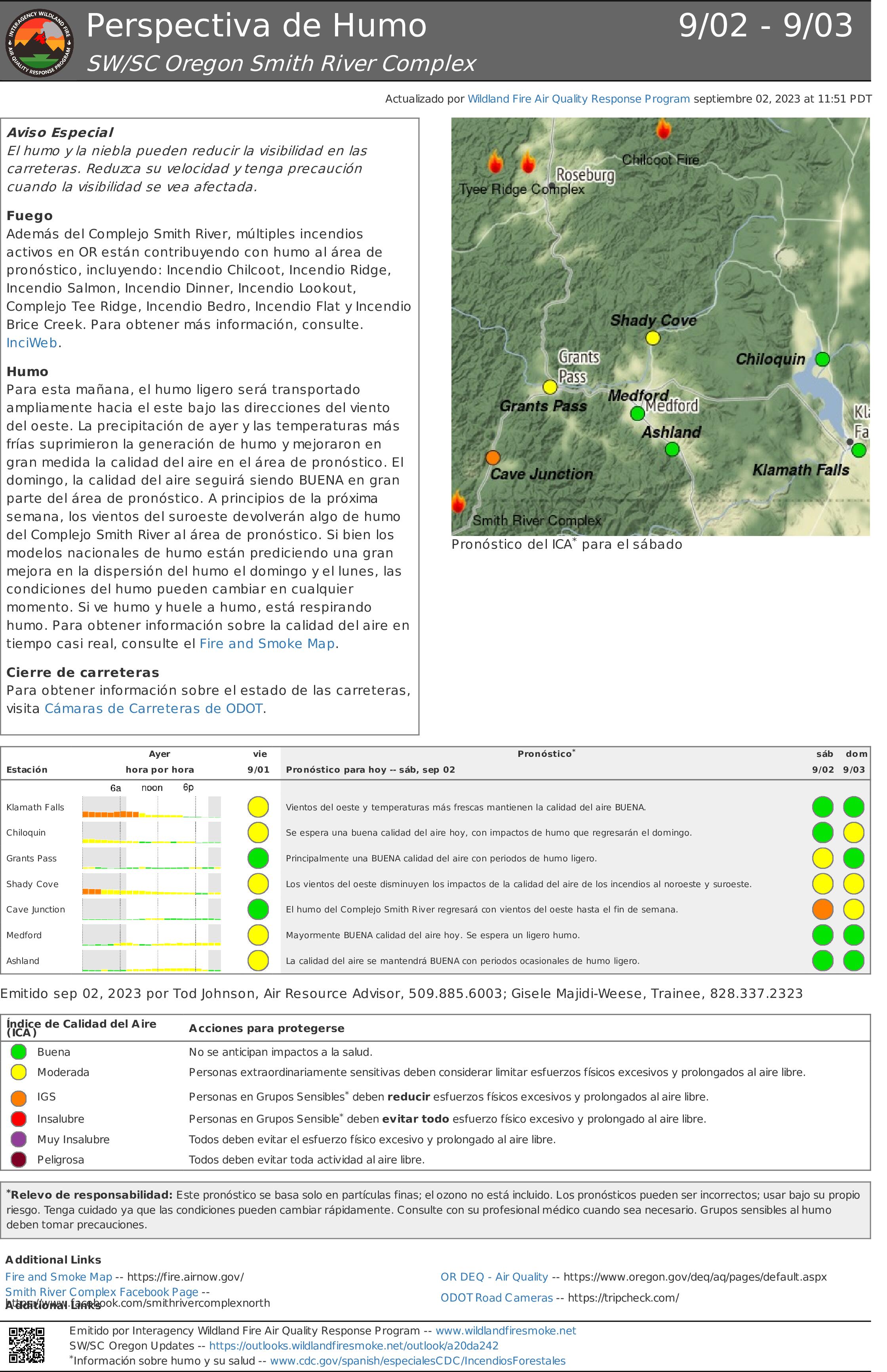
Perspectiva de Humo Smith River Complex 902 903
Related Incident: Smith River Complex
Publication Type: News
Aviso Especial
El humo y la niebla pueden reducir la visibilidad en las carreteras. Reduzca su velocidad y tenga precaución cuando la visibilidad se vea afectada.
Fuego
Además del Complejo Smith River, múltiples incendios activos en OR están contribuyendo con humo al área de pronóstico, incluyendo: Incendio Chilcoot, Incendio Ridge, Incendio Salmon, Incendio Dinner, Incendio Lookout, Complejo Tee Ridge, Incendio Bedro, Incendio Flat y Incendio Brice Creek. Para obtener más información, consulte InciWeb.
Humo
Para esta mañana, el humo ligero será transportado ampliamente hacia el este bajo las direcciones del viento del oeste. La precipitación de ayer y las temperaturas más frías suprimieron la generación de humo y mejoraron en gran medida la calidad del aire en el área de pronóstico. El domingo, la calidad del aire seguirá siendo BUENA en gran parte del área de pronóstico. A principios de la próxima semana, los vientos del suroeste devolverán algo de humo del Complejo Smith River al área de pronóstico. Si bien los modelos nacionales de humo están prediciendo una gran mejora en la dispersión del humo el domingo y el lunes, las condiciones del humo pueden cambiar en cualquier momento. Si ve humo y huele a humo, está respirando humo. Para obtener información sobre la calidad del aire en tiempo casi real, consulte el Fire and Smoke Map.
Cierre de carreteras
Para obtener información sobre el estado de las carreteras, visita Cámaras de Carreteras de ODOT.
Informacin al da para el Incendio Smith River Complex South sbado 2 de septiembre 2023
Related Incident: Smith River Complex
Publication Type: News
Fecha de inicio: 15 de agosto de 2023
Ubicación: Bosque Nacional Six Rivers
Causa: Relampagos
Acres: 83,974
Contención: 9%
Personal: 3,031
Más niveles de evacuación actualizados
Reflejos: El Departamento del Sheriff del Condado de Del Norte, en colaboración con la Oficina de Servicios de Emergencia del Condado de Del Norte, redujo el nivel de evacuación en Patrick Creek Lodge y el área residencial de Little Jones/Washington Flat al NIVEL 2. La repoblación de estas comunidades comenzó el Viernes 1 de Septiembre al mediodía. Un Mapa de evacuacion Interactiva está disponible para mantener a los residentes informados sobre los Niveles de evacuación actuales. Se alienta a los residentes a permanecer atentos ya que el nivel de evacuación podría aumentar nuevamente si la actividad del incendio y las condiciones cambian. Todas las carreteras del condado permanecen cerradas al público en NIVEL 3.
Operaciones: Los bomberos aprovecharon el clima favorable para quemar varias pilas de tala en la huella del Smith Rivers Complex. (Las pilas de tala son el resultado de las operaciones de raleo del tratamiento forestal realizadas anteriormente por el Bosque Nacional). Con la lluvia que se producirá en los próximos días, las cuadrillas planean continuar con las operaciones de quema táctica para detener el crecimiento del fuego. La alta humedad y las fuertes lluvias mantendrán el fuego activo al mínimo, siendo el principal portador del fuego los combustibles pesados y caídos. Sin embargo, la lluvia recibida anoche no fue suficiente para sofocar por completo los incendios dentro del Smith River Complex.
Clima: Una advertencia de inundación repentina permanece vigente: Advertencia de inundación repentina de la NOAA Las fuertes lluvias del viernes mostraron mediciones de cerca de una pulgada en algunas áreas. Anoche se registraron 75 rayos dentro de nuestra área de respuesta. Es probable que el humo aumente en los próximos 3 a 5 días.
Seguridad: El tráfico de bomberos combinado con vehículos comerciales pilotados podría conducir a áreas congestionadas en la autopista 199. Absténgase de realizar viajes innecesarios, especialmente entre las 6:30 a. m. y las 8:30 a. m.
Restricciones/Cierres: Los cierres se ajustarán según la actividad del incendio. Todas las carreteras del condado permanecerán cerradas y en NIVEL 3. La autopista 199 permanece cerrada al norte de Pioneer Road. Además, Rowdy Creek Road permanece cerrada en la parte superior de Low Divide.
Humo: La información sobre la calidad del aire está disponible en https://www.airnow.gov/
Evacuaciones: Todas las órdenes de evacuación son emitidas por la Oficina del Sheriff del Condado de Del Norte. Si se encuentra en el área del condado de Del Norte, regístrese en su Sistema de alerta comunitaria para recibir notificaciones de emergencia. Niveles de evacuación al 1 de septiembre, 12:00 del mediodía, como sigue: Mapa de evacuacion Interactiva
NIVEL 3 “Vaya ahora”: Consulte el mapa de evacuación interactivo para las carreteras del NIVEL 3.
NIVEL 2 “Prepárese”: Gasquet, Rowdy Creek/Low Divide, Big Flat/Rock Creek, Patrick Creek, Patrick Creek Lodge, Little Jones/Washington Flat Área residencial.
NIVEL 1 “Esté preparado”: Hiouchi
Información sobre incendios: 2023.smithrivercomplex@firenet.gov
InciWeb: https://inciweb.nwcg.gov/incident-information/casrf-smith-river-complex
Facebook: https://www.facebook.com/SixRiversNF
Josephine County Sheriff announces reduction of evacuation level September 2
Related Incident: Smith River Complex
Publication Type: Announcement
Notice from Josephine County Sheriff: Reduce to Level 2 BE SET to evacuate Smith River Complex North 2023
Notice from Josephine County Sheriff. Reduce to Level 2 - BE SET to evacuate from Community of O'Brien: Hwy 199 South of mile post 38 to the California border. Be ready to evacuate at a moment’s notice. Find resources at wildfire.oregon.gov. Act early if there is any reason you might need extra time. Leave right away if you feel you are in immediate danger. If conditions change quickly, this may be the only alert you receive. For more information, visit: www.rvem.org 541-801-3495
**************
Under the www.rvem.org site go to the Fire First Response Map for the latest evacuation map.
Josephine County Emergency Management has the latest evacuation notices at their 2023 Fire Season Information page.
Del Norte County Emergency Services Facebook page has updates about evacuations on Smith River Complex - South Zone.