
Lions Camp Road Daily Update 9223
Related Incident: Lions Camp Road Fire
Publication Type: News
Louisiana Statewide Burn Ban: The state of Louisiana has declared a statewide burn ban to include any open flame outdoors. The message from the State Fire Marshal’s Office is “don’t burn anything” until further notice. Citations and arrests ARE happening across this state in partnership with local and state law enforcement agencies.
Tiger Island Fire acreage: 31342
Hwy 113 Fire acreage: 7031
Lions Camp Road Fire acreage: 579
Elizabeth Fire acreage: 943
Total Personnel: 324
Personnel and Equipment:
Tiger Island: 1 Type-1 Crew; 5 Helicopters, 2 fixed-wing aircraft, 19 Type-6 Engines, 15 Type-2 Tractor Plow Units, 5 Type-3 Tractor Plow Units, 4 Dozers, 7 Water Tenders and 5 Ambulances.
Hwy 113: 1 Type-1 Crew; 9 dozers; 4 Type-6 Engines
Lions Camp Road: 1 Type-6 Engine
Elizabeth: 1 Type-6 Engine; 8 dozers
Additional support is being provided to all fires by the National Guard, Parish authorities, the Governor’s Office of Homeland Security and Emergency Preparedness, the Louisiana State Fire Marshal Team, Sheriff’s offices, and the Offices of Emergency Preparedness.
Tiger Island Fire: The Tiger Island Fire was first reported on Tuesday, August 22nd. The fire is located east of Merryville, south of Hwy 190, SW of DeRidder and North of Singer. The fire is burning in pine plantations of multiple ages. Heavy residual fuels because of Hurricane Laura in 2020 exist and contribute to extreme fire behavior.
Operations: The Tiger Island Fire is currently 50% contained. On Friday, crews found increased needle cast across the fire area which can contribute to the fire reburning when dry needles fall onto areas of heat. Heat was detected on the interior northwest side of the fire near Nichols-Sibley Road moving south, and on the interior east side of the fire near Neale Oilfield Road, south of the railroad. Crews worked on strengthening and improving the containment line in those areas and continued to mop up around the fire perimeter. Today, crews will continue to mop up all perimeter lines of the fire, in particular along Neale Oilfield Road near Merryville and along the hardwood creek bottom on the northern perimeter of the fire. Crews will be reinforcing dozer lines on the northwest side of the fire where heat was detected yesterday, keeping the fire perimeter south of Shinn Road.
Hwy 113 Fire: Located 14 miles northwest of Oakdale. This fire is burning in loblolly pines and hardwoods.
Operations: The Hwy 113 Fire is currently 50% contained. Yesterday, aerial support slowed fire growth. The National Guard constructed dozer line along the north side of the fire. Today, crews will continue to install dozer line around the fire perimeter. The structure protection group will be working with local and state partners today on the fire to respond to structure protection needs.
Lions Camp Road: Five miles northwest of Leesville. This fire is burning is southern rough, timber and brush.
Operations: Today, crews will be working to patrol existing firelines and will identify areas to improve these containment lines and begin mop up to maintain the current fire perimeter.
Elizabeth: Located in southwest Rapides Parish.
Operations: The Elizabeth Fire is currently 50% contained. Yesterday, there was active fire growth on the northwest side of the fire. Crews will be constructing and improving containment lines today and patrolling for hot spots.
Weather and Fire Behavior: Higher than normal air temperatures with a high heat index are expected today. Temperatures may reach 100 degrees, with humidity levels in the low 30’s. Winds are expected from the east/northeast with gusts of up to 18 mph. The increased humidity may bring scattered showers, heavy rain, thunderstorms, and gusty and erratic winds by this afternoon. Dry fuel conditions and increased needle cast, combined with gusty winds, can increase reburn potential in fire areas and increase the potential for extreme fire behavior. The erratic winds can come from variable directions and could push a seabreeze into the area this evening.
Air Quality: All four fires are projected to produce low levels of smoke. If there is active fire behavior with fire progression, or new starts, there could be high levels of smoke for short durations in the vicinity of the fire. The thunderstorms with gusty and erratic winds expected today could move smoke in any direction and disperse it. Smoke from the Tiger Island Fire will be most apparent in the Merryville area. Smoke from Elizabeth and Hwy 113 fires will be heaviest in the Pitkin area. Smoke from the Lions Camp Rd Fire may move across Vernon Lake and toward the Sabine River. Expect increased smoke at Lake Charles with E winds due to a new start ESE of town. Smoke should decrease after sea breezes start. Lafayette and Leesville should have less smoke with the ENE winds. For near time air quality information see EPA's Fire and Smoke Map: https://fire.airnow.gov/
Temporary Flight Restriction: A Temporary Flight Restriction (TFR) is in place over the Tiger Island Fire and Hwy 113 and Elizabeth Fire areas. This is necessary to protect aerial operations. If you fly, we can’t. If there are drone intrusions into the Temporary Flight Restrictions, we must ground all aircraft.
Evacuations: Updates on evacuations and shelters for the Tiger Island Fire can be found on the Beauregard Parish Sheriff’s Office Facebook Page at https://www.facebook.com/beauregardsheriff.
Hwy 113 Fire Daily Update 9223
Related Incident:
Publication Type: News
Louisiana Statewide Burn Ban: The state of Louisiana has declared a statewide burn ban to include any open flame outdoors. The message from the State Fire Marshal’s Office is “don’t burn anything” until further notice. Citations and arrests ARE happening across this state in partnership with local and state law enforcement agencies.
Tiger Island Fire acreage: 31342
Hwy 113 Fire acreage: 7031
Lions Camp Road Fire acreage: 579
Elizabeth Fire acreage: 943
Total Personnel: 324
Personnel and Equipment:
Tiger Island: 1 Type-1 Crew; 5 Helicopters, 2 fixed-wing aircraft, 19 Type-6 Engines, 15 Type-2 Tractor Plow Units, 5 Type-3 Tractor Plow Units, 4 Dozers, 7 Water Tenders and 5 Ambulances.
Hwy 113: 1 Type-1 Crew; 9 dozers; 4 Type-6 Engines
Lions Camp Road: 1 Type-6 Engine
Elizabeth: 1 Type-6 Engine; 8 dozers
Additional support is being provided to all fires by the National Guard, Parish authorities, the Governor’s Office of Homeland Security and Emergency Preparedness, the Louisiana State Fire Marshal Team, Sheriff’s offices, and the Offices of Emergency Preparedness.
Tiger Island Fire: The Tiger Island Fire was first reported on Tuesday, August 22nd. The fire is located east of Merryville, south of Hwy 190, SW of DeRidder and North of Singer. The fire is burning in pine plantations of multiple ages. Heavy residual fuels because of Hurricane Laura in 2020 exist and contribute to extreme fire behavior.
Operations: The Tiger Island Fire is currently 50% contained. On Friday, crews found increased needle cast across the fire area which can contribute to the fire reburning when dry needles fall onto areas of heat. Heat was detected on the interior northwest side of the fire near Nichols-Sibley Road moving south, and on the interior east side of the fire near Neale Oilfield Road, south of the railroad. Crews worked on strengthening and improving the containment line in those areas and continued to mop up around the fire perimeter. Today, crews will continue to mop up all perimeter lines of the fire, in particular along Neale Oilfield Road near Merryville and along the hardwood creek bottom on the northern perimeter of the fire. Crews will be reinforcing dozer lines on the northwest side of the fire where heat was detected yesterday, keeping the fire perimeter south of Shinn Road.
Hwy 113 Fire: Located 14 miles northwest of Oakdale. This fire is burning in loblolly pines and hardwoods.
Operations: The Hwy 113 Fire is currently 50% contained. Yesterday, aerial support slowed fire growth. The National Guard constructed dozer line along the north side of the fire. Today, crews will continue to install dozer line around the fire perimeter. The structure protection group will be working with local and state partners today on the fire to respond to structure protection needs.
Lions Camp Road: Five miles northwest of Leesville. This fire is burning is southern rough, timber and brush.
Operations: Today, crews will be working to patrol existing firelines and will identify areas to improve these containment lines and begin mop up to maintain the current fire perimeter.
Elizabeth: Located in southwest Rapides Parish.
Operations: The Elizabeth Fire is currently 50% contained. Yesterday, there was active fire growth on the northwest side of the fire. Crews will be constructing and improving containment lines today and patrolling for hot spots.
Weather and Fire Behavior: Higher than normal air temperatures with a high heat index are expected today. Temperatures may reach 100 degrees, with humidity levels in the low 30’s. Winds are expected from the east/northeast with gusts of up to 18 mph. The increased humidity may bring scattered showers, heavy rain, thunderstorms, and gusty and erratic winds by this afternoon. Dry fuel conditions and increased needle cast, combined with gusty winds, can increase reburn potential in fire areas and increase the potential for extreme fire behavior. The erratic winds can come from variable directions and could push a seabreeze into the area this evening.
Air Quality: All four fires are projected to produce low levels of smoke. If there is active fire behavior with fire progression, or new starts, there could be high levels of smoke for short durations in the vicinity of the fire. The thunderstorms with gusty and erratic winds expected today could move smoke in any direction and disperse it. Smoke from the Tiger Island Fire will be most apparent in the Merryville area. Smoke from Elizabeth and Hwy 113 fires will be heaviest in the Pitkin area. Smoke from the Lions Camp Rd Fire may move across Vernon Lake and toward the Sabine River. Expect increased smoke at Lake Charles with E winds due to a new start ESE of town. Smoke should decrease after sea breezes start. Lafayette and Leesville should have less smoke with the ENE winds. For near time air quality information see EPA's Fire and Smoke Map: https://fire.airnow.gov/
Temporary Flight Restriction: A Temporary Flight Restriction (TFR) is in place over the Tiger Island Fire and Hwy 113 and Elizabeth Fire areas. This is necessary to protect aerial operations. If you fly, we can’t. If there are drone intrusions into the Temporary Flight Restrictions, we must ground all aircraft.
Evacuations: Updates on evacuations and shelters for the Tiger Island Fire can be found on the Beauregard Parish Sheriff’s Office Facebook Page at https://www.facebook.com/beauregardsheriff.
Tiger Island Fire Daily Update 9223
Related Incident: Tiger Island Fire
Publication Type: News
Louisiana Statewide Burn Ban: The state of Louisiana has declared a statewide burn ban to include any open flame outdoors. The message from the State Fire Marshal’s Office is “don’t burn anything” until further notice. Citations and arrests ARE happening across this state in partnership with local and state law enforcement agencies.
Tiger Island Fire acreage: 31342
Hwy 113 Fire acreage: 7031
Lions Camp Road Fire acreage: 579
Elizabeth Fire acreage: 943
Total Personnel: 324
Personnel and Equipment:
Tiger Island: 1 Type-1 Crew; 5 Helicopters, 2 fixed-wing aircraft, 19 Type-6 Engines, 15 Type-2 Tractor Plow Units, 5 Type-3 Tractor Plow Units, 4 Dozers, 7 Water Tenders and 5 Ambulances.
Hwy 113: 1 Type-1 Crew; 9 dozers; 4 Type-6 Engines
Lions Camp Road: 1 Type-6 Engine
Elizabeth: 1 Type-6 Engine; 8 dozers
Additional support is being provided to all fires by the National Guard, Parish authorities, the Governor’s Office of Homeland Security and Emergency Preparedness, the Louisiana State Fire Marshal Team, Sheriff’s offices, and the Offices of Emergency Preparedness.
Tiger Island Fire: The Tiger Island Fire was first reported on Tuesday, August 22nd. The fire is located east of Merryville, south of Hwy 190, SW of DeRidder and North of Singer. The fire is burning in pine plantations of multiple ages. Heavy residual fuels because of Hurricane Laura in 2020 exist and contribute to extreme fire behavior.
Operations: The Tiger Island Fire is currently 50% contained. On Friday, crews found increased needle cast across the fire area which can contribute to the fire reburning when dry needles fall onto areas of heat. Heat was detected on the interior northwest side of the fire near Nichols-Sibley Road moving south, and on the interior east side of the fire near Neale Oilfield Road, south of the railroad. Crews worked on strengthening and improving the containment line in those areas and continued to mop up around the fire perimeter. Today, crews will continue to mop up all perimeter lines of the fire, in particular along Neale Oilfield Road near Merryville and along the hardwood creek bottom on the northern perimeter of the fire. Crews will be reinforcing dozer lines on the northwest side of the fire where heat was detected yesterday, keeping the fire perimeter south of Shinn Road.
Hwy 113 Fire: Located 14 miles northwest of Oakdale. This fire is burning in loblolly pines and hardwoods.
Operations: The Hwy 113 Fire is currently 50% contained. Yesterday, aerial support slowed fire growth. The National Guard constructed dozer line along the north side of the fire. Today, crews will continue to install dozer line around the fire perimeter. The structure protection group will be working with local and state partners today on the fire to respond to structure protection needs.
Lions Camp Road: Five miles northwest of Leesville. This fire is burning is southern rough, timber and brush.
Operations: Today, crews will be working to patrol existing firelines and will identify areas to improve these containment lines and begin mop up to maintain the current fire perimeter.
Elizabeth: Located in southwest Rapides Parish.
Operations: The Elizabeth Fire is currently 50% contained. Yesterday, there was active fire growth on the northwest side of the fire. Crews will be constructing and improving containment lines today and patrolling for hot spots.
Weather and Fire Behavior: Higher than normal air temperatures with a high heat index are expected today. Temperatures may reach 100 degrees, with humidity levels in the low 30’s. Winds are expected from the east/northeast with gusts of up to 18 mph. The increased humidity may bring scattered showers, heavy rain, thunderstorms, and gusty and erratic winds by this afternoon. Dry fuel conditions and increased needle cast, combined with gusty winds, can increase reburn potential in fire areas and increase the potential for extreme fire behavior. The erratic winds can come from variable directions and could push a seabreeze into the area this evening.
Air Quality: All four fires are projected to produce low levels of smoke. If there is active fire behavior with fire progression, or new starts, there could be high levels of smoke for short durations in the vicinity of the fire. The thunderstorms with gusty and erratic winds expected today could move smoke in any direction and disperse it. Smoke from the Tiger Island Fire will be most apparent in the Merryville area. Smoke from Elizabeth and Hwy 113 fires will be heaviest in the Pitkin area. Smoke from the Lions Camp Rd Fire may move across Vernon Lake and toward the Sabine River. Expect increased smoke at Lake Charles with E winds due to a new start ESE of town. Smoke should decrease after sea breezes start. Lafayette and Leesville should have less smoke with the ENE winds. For near time air quality information see EPA's Fire and Smoke Map: https://fire.airnow.gov/
Temporary Flight Restriction: A Temporary Flight Restriction (TFR) is in place over the Tiger Island Fire and Hwy 113 and Elizabeth Fire areas. This is necessary to protect aerial operations. If you fly, we can’t. If there are drone intrusions into the Temporary Flight Restrictions, we must ground all aircraft.
Evacuations: Updates on evacuations and shelters for the Tiger Island Fire can be found on the Beauregard Parish Sheriff’s Office Facebook Page at https://www.facebook.com/beauregardsheriff.
South Fork Complex Update September 2 2023
Related Incident: South Fork Complex
Publication Type: News
South Fork Complex Update
Saturday, September 2, 2023
Fire Information: 530-638-2830, 8 a.m. to 8 p.m.
Email: 2023.southforkcomplex@firenet.gov
Linktree: linktr.ee/southforkcomplex2023
3-9 Fire: 2,869 acres with 35% containment
Pellitreau Fire: 3 acres with 100% containment
Pilot Fire: 1,055 acres with 100% containment
Sulphur Fire: 31 acres with 100% containment
52% overall containment for the South Fork Complex
Current Situation:
As of 6:00 p.m. on September 1, 2023, California Interagency Incident Management Team 14 assumed command of the South Fork Complex. A total of 873 personnel, crews, air support, engines, dozers, and water tenders continue to support the incident.
3-9 Fire The majority of the South Fork Complex footprint, including the 3-9 Fire, received wetting rain yesterday. As a result, fuels have been moderately wet and fire behavior potential low. However, smoldering, heavy fuels persist, and fine fuels are expected to dry out with warmer, drier weather in coming days. Firefighters continue to improve control lines along the southern perimeter of the fire along Berry-Summit-Mad River Road (Route 1), Henry Ridge, and Pilot Creek. Crews continue to evaluate opportunities to go direct on the fire whenever it is safe to do. Along the northern and northeastern perimeter, crews continue to mop up and secure control lines. Firefighters will continue to find ways to take advantage of the cooler temperatures and precipitation to construct control lines directly on the fire’s edge.
Pilot Fire is 100% contained. Firefighters will continue to backhaul unneeded supplies as well as monitor and patrol the fire perimeter to ensure that the fire remains within the containment lines.
The Pellitreau Fire and the Sulfur Fire are 100% contained. Firefighters will continue to monitor and patrol to ensure fire remains within the containment lines.
Weather: Dense fog this morning will reduce visibility in the area. This fog is forecasted to mix out of the area by early afternoon. There is a 50% chance of wetting rain today with a chance of isolated thunderstorms in the afternoon. Maximum temperatures are expected to be 55-60 ºF, and minimum relative humidities are expected to be 60-70%. Southeast winds are predicted to be 6-10 mph with gusts up to 15 mph.
Evacuation Warning: In Humboldt County, an Evacuation Warning continues to be in place for Zone HUM-E114-A and Zone HUM E114-B. For more information go to the Humboldt County Sheriff’s Office website or call 707-268-2500. In Trinity County, an Evacuation Warning continues to be in effect for Zone HYM-505 and Zone HYM-509. Please continue to check the Trinity County Wildfire and Evacuation website for up-to-date information.
Forest Closure: Forest Closure orders for the South Fork Complex Fire continue to be in effect and are posted on the Shasta-Trinity National Forest and the Six Rivers National Forest websites. Please avoid closed areas.
Game Preserve Fire Daily Update September 2 2023
Related Incident:
Publication Type: News
Game Preserve Fire Daily Update
September 2, 2023
10:00 am
Size: 3,000 acres
Containment: 10%
Start Date: September 1, 2023
Cause: Under Investigation
On September 1, 2023, Texas A&M Forest Service received a request for a fire on Lost Indian Camp Road off State Highway 247, 9 miles northwest of Huntsville, Texas. The fire continues to actively burn in pine timber with grass and yaupon understory.
Overnight, crews from Texas A&M Forest Service and local fire departments engaged in suppression efforts with constructing dozer lines. Fire activity continued through the night causing further evacuations and a temporary road closure on Interstate 45.
Local and state crews are back on scene today with fresh resources. Multiple pieces of heavy equipment and engines continue to build containment lines along the fire perimeter and improve existing containment lines. Two Texas Intrastate Fire Mutual Aid System (TIFMAS) engine strike teams are providing structure protection for those near the fire perimeter including Cedar Ridge subdivision. Aviation resources have been requested and are on scene to slow forward progression towards Interstate 45 (I-45). Additional resources continue to enter the area to preposition and assist for this afternoon.
Weather:
Upper trough continues to dig into the northern Gulf of Mexico and will therefore introduce more dry air into the region. The current weather pattern of below 30 percent relative humidity levels and northwesterly winds ranging between 5-10 mph, with occasional gusts up to 15 mph will remain in place.
Evacuations:
Evacuations were ordered for all residents within 3 miles of Lost Indian Camp Road. As the evening progressed, growth from the fire prompted additional evacuations from Cedar Ridge subdivision. All evacuation orders remain in place. Residents being evacuated should take all people and pets, personal items, prescriptions, important papers, and priceless items with them. Have enough of these necessary items to be out of the area for 24-48 hours.
Closures:
Portions of State Highway 247 are currently closured from farm to market road (FM) 2628 to FM 2989. Last night, the growth of the fire caused Interstate 45 (I-45) to temporarily close. I-45 is currently open. Additional information on road closures in the area can be found on www.drivetexas.org.
Damages and Injuries:
Currently, there have been no reports of injuries from the public or first responders. No structure or critical infrastructure have been lost.
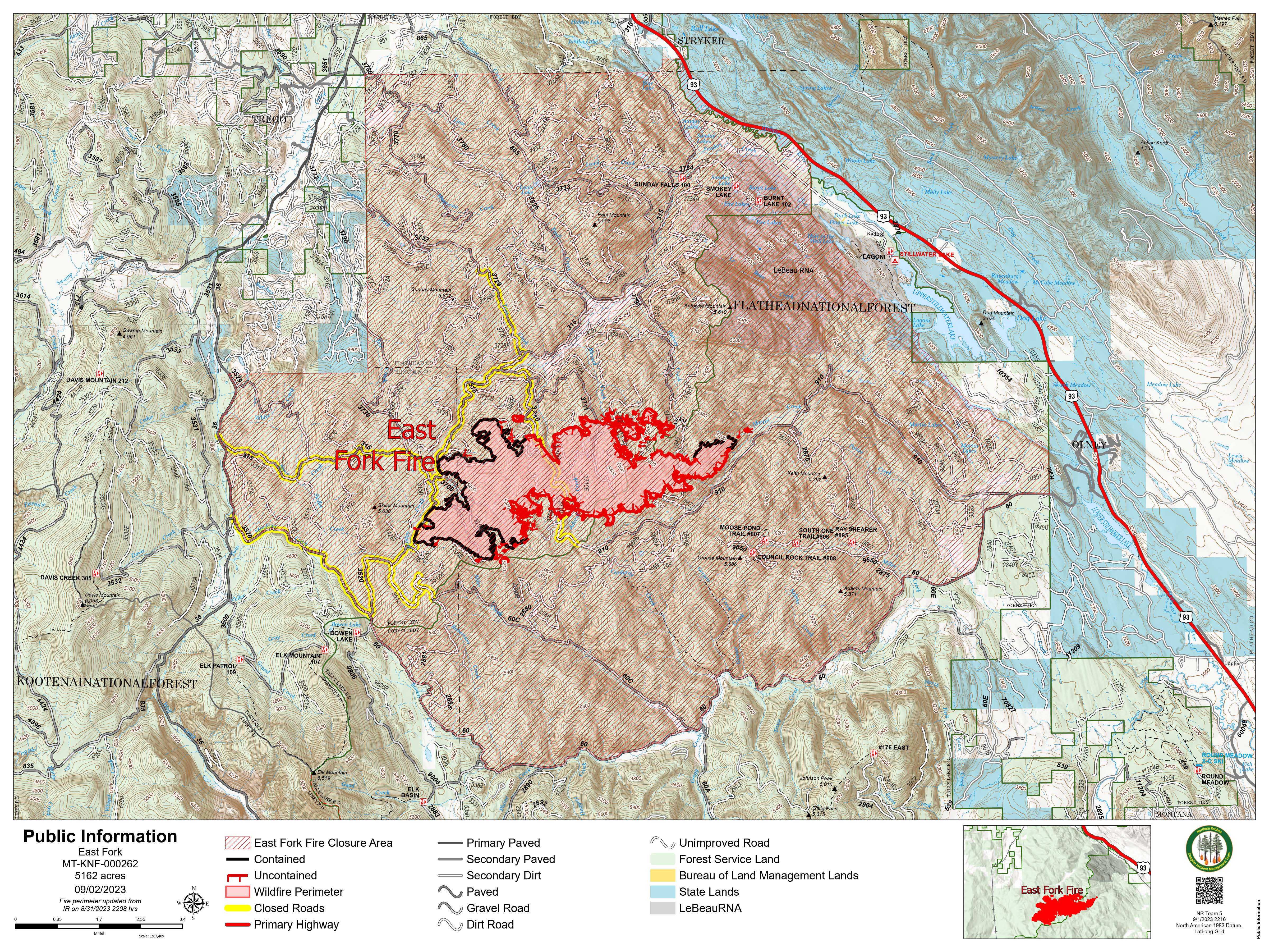
East Fork Fire September 2 2023 Update
Related Incident: East Fork Fire
Publication Type: News
East Fork Fire
News - 09/01/2023
Location: 12 miles south of Trego, Montana
Information Line: 406-285-8634
Start Date: 7/30/2023
Cause: Lightning
Size: 5162 acres
Containment: 30%
Total Personnel: 588
Engines: 13
Helicopters: 2
Hand Crews: 10
CURRENT STATUS
Firefighters removed hazardous trees from the fire area. Heavy equipment assisted crews in removal areas by transporting trees off the fire line. The fire produced scattered smoke along the fire’s northern and southeast perimeter, however, crews mopped up the residual heat they found in these areas. Crews patrolled the southwest portion of the fire line, however, few areas of heat were detected along the fire’s perimeter.
PLANNED ACTION
Crews will continue to patrol areas along the fire’s perimeter, mopping up residual heat along the fire’s edge as they find it. With rising temperatures today, crews will likely be able to find additional pockets of heat that were not visible along the fire’s edge earlier in the week.
Due to muddy roads from heavy rainfall earlier in the week, heavy equipment will not be accessing lines previously constructed as contingency line further from the fire’s edge. Instead, their efforts will focus on improving line directly along the fire’s edge where roads are drier. In these areas, heavy equipment will assist ground crews with felling and removing hazardous trees.
Over the next few days, crews will connect sections of hand line together along the fire’s edge. Connecting these areas of handline prevents the fire from crossing into unburned territory in areas where handline wasn’t previously constructed. This process will likely take a few more days and then crews will pivot to repairing areas of line constructed in early August that are no longer needed to suppress fire activity.
WEATHER AND FIRE BEHAVIOR
More smoke may be visible in the fire area as temperatures rise into the mid to high 70s today. Winds may also pick up to about 15 mph with relative humidities in the mid 30s. Scattered smoke will likely be most visible in the area surrounding Blessed Creek and Advent Creek, with this active burning posing no threat to expanding the fire’s current acreage or perimeter.
CLOSURES AND EVACUATIONS
Lincoln and Flathead Counties have lifted all pre-evacuation orders. For more information, visit the Lincoln County and Flathead County Sheriff’s Department Facebook pages.
SPECIAL MESSAGES
Adhere to all road closure signs when driving or recreating in the East Fork Fire area. Closure Order 01-14-03-23-10 is still in effect on the Kootenai National Forest and Flathead National Forest for roads in the vicinity of the East Fork Fire. The purpose of this order is to provide for public and firefighter safety. All road closures are located South of Trego, Montana. Specific information about the closure area can be found at https://www.fs.usda.gov/alerts/kootenai/alerts-notices/?aid=82240
Quartz Ridge and Bear Creek Fires Daily Update September 2 2023
Related Incident: Quartz Ridge FireBear Creek Fire
Publication Type: News
September 2, 2023
Type 3 Team, Incident Commander: Nick Collard ICT3, Grif Cochran ICT3 (T)
Daily Update – 9:00 AM
Highlights: San Juan National Forest has lifted Stage 1 Fire Restrictions as of August 31, 2023. Fire activity is expected to be minimal with smoldering, creeping, and backing where pockets of heat remain. Scattered areas of heat may produce more smoke today as conditions continue to dry out. Resources are available to respond quickly if conditions change. The next daily update will be on Tuesday, September 5, 2023 unless significant fire events occur.
Quartz Ridge Fire: 1,840 acres, no change in acreage | 77% of objectives achieved | 53 personnel assigned
Crews continue to work on building a shaded fuel break along Quartz Meadows Rd (NFSR#684). Direct control lines are being utilized to suppress accessible parts of the fire and indirect control lines are providing confinement on remote areas that present high safety risks to firefighters.
Bear Creek Fire: 443 acres, no change in acreage | 83% of objectives achieved | 15 personnel assigned
Minimal fire behavior is expected, but more active fire behavior may produce smoke as conditions continue to dry out. Fire spread is not expected as fuel moistures remain elevated.
Weather: Slight chance of showers and thunderstorms in the afternoon and evening. High temperatures will be in the mid to upper 60s with afternoon relative humidity of 20 to 35%. Gusty and erratic winds can be expected near thunderstorms.
San Juan National Forest Temporary Closures: Closure orders are in effect and additional information can be found here. Roads and trails within the Quartz Fire area are Quartz Meadows Rd (NFSR#684), Quartz Ridge Trail (NFST#570), Quartz Creek Trail (NFST#571). Trails within the Bear Creek Fire area are Little Sand Trail (NFST #591), and Shaw Creek Trail (NFST#584).
Pagosa Springs, Cloman Park: Cloman Park is no longer being used as a camp for fire crews and is available for public use as determined by the city.
Fire Information
Office Hours: 8:00 AM – 8:00 PM
Phone: 970-426-5370
Quartz Ridge Fire
Email: 2023.QuartzRidge@firenet.gov
InciWeb:
https://inciweb.nwcg.gov/incident-information/cosjf-quartz-ridge-fire
https://www.facebook.com/profile.php?id=100095556640621
Bear Creek Fire
Email: 2023.BearCreek@firenet.gov
Inciweb
https://inciweb.nwcg.gov/incident-information/cosjf-bear-creek-fire
Flat Fire and Anvil Fire Morning Update 09022023
Related Incident: Flat FireAnvil Fire
Publication Type: News
An Anvil Fire specific Inciweb page has been set up. It can be accessed at bit.ly/AnvilFireOR
Flat Fire Activity
Size: 34,242 acres Start Date: July 15, 2023 Point of origin: 2 miles southeast of Agness, OR
Containment: 58% Total personnel: 416
Resources: 5 crews, 6 helicopters, 14 engines, 9 water tenders, 12 pieces of heavy equipment
Crews continue to identify and backhaul equipment around the fire perimeter, including sprinkler systems, hoses, pumps, and water tanks. Hand crews and excavator operators are pulling in berms on alternate heavy equipment lines and adding water bars to prevent erosion. Chipping activity continues on the southern end along Forest Road 109. Once that is complete, the chipper will be used in other areas around the fire. Firefighters are patrolling and monitoring around the fire, keeping a close watch on the uncontained line on the eastern perimeter. Smoke may be visible within the firelines as interior fuel pockets burn out. Initial Attack resources are staged and ready to assist the Forest if needed.
Anvil Fire Activity
Size: 135 acres Start Date: August 25, 2023 Point of origin: 8 miles east of Port Orford, OR
Containment: 0% Total personnel: 119
Resources: 4 crews, 1 helicopter, 4 engines, 3 water tenders, 1 piece of heavy equipment
The Anvil Fire strategy is to keep the footprint as small as possible. However, due to the steep slopes, rugged terrain, and snags (dead standing trees) creating safety issues, fire managers are assessing options for fighting the fire. Options include indirect (creating line a distance from the fire’s edge with a higher probability of success and lower risk to firefighters) and direct attack (building line at the fire’s edge), and point protection. If weather allows, a reconnaissance flight will be conducted today to identify ridgelines that could be used for alternative control lines. Crews are beginning to assess along the Elk River and Sixes River roads to identify structures and determine point protection needs. This could include removing vegetation and flammable materials from around houses and other structures and setting up sprinkler systems with hoses and pumps. Property owners can expect to begin seeing firefighters in these areas. Aircraft will continue to support firefighters as conditions allow.
Weather: Some moisture fell on both fires yesterday. The weather will remain cool with higher humidity for a few more days. However, temperatures will slowly rise next week, and humidity will drop, potentially resulting in increased fire behavior.
Smoke: The smoke outlook for the Smith River Complex and surrounding fires, including the Flat Fire, can be found at https://tinyurl.com/smokeoutlook. Precipitation and cooler temperatures should suppress smoke generation and improve air quality through Saturday afternoon. Sunday, southwest winds will bring smoke back into the forecast area.
Closures: U.S. Highway 199 is closed north of Gasquet due to fires on the Six Rivers National Forest. Please use U.S. Route 101 to SR 42 for all travel to and from the Rogue Valley. Forest Service and BLM roads should not be used as alternate routes due to emerging fire activity. The Rogue River-Siskiyou National Forest (RRSNF) has issued a closure order. For more information, visit https://bit.ly/RRSNFAlerts.
Evacuations: Level 1 “Get Ready” evacuation status is in place for areas near the Flat Fire. Level 2 “Get Set“ evacuation status is in place along the Elk River from about milepost 4 to the USFS Butler Bar Campground near the Anvil Fire. Visit https://bit.ly/CurryCoEM for more information and to sign up for alerts.
Restrictions: There are currently Level 3 Public Use Restrictions (PUR) in the area. Visit https://bit.ly/RRSNFAlerts for more information. There is a Temporary Flight Restriction (TFR) over the fire areas. Please do not fly unmanned aircraft (drones) in the fire vicinity. If you fly, we can't.
Elizabeth Fire Smoke Report 09022023
Related Incident: Elizabeth Fire
Publication Type: News
Special Statement: Visibility can be reduced in areas with both smoke and fog. Exercise caution if driving in these conditions.
Fire
The four fires in the area are Tiger Island (31,342 ac); Elizabeth (970 ac); Hwy. 113 (9000 ac) and Lions Camp Rd. (579 ac). The potential for increased fire activity is lower today. Tiger Island: (visit Inciweb Tiger Island Fire for more details) Elizabeth: (visit Inciweb Elizabeth Fire for more details) Hwy. 113:(visit Inciweb Hwy 113 Fire for more details) Lions Camp Rd: (visit Inciweb Lions Camp Road Fire).
Smoke
Smoke in localized areas near the fires and on roads adjacent to them. If there is active fire behavior with fire progression, or new starts, there could be high levels of smoke for short durations in the vicinity of the fire. There is a chance for thunderstorms with gusty and erratic winds that could move smoke in any direction and disperse it. Smoke from the Tiger Island Fire will be most apparent in the Merryville area. Smoke from Elizabeth and Hwy. 113 fires will be heaviest in the Pitkin area. Smoke from the Lions Camp Rd Fire may move across Vernon Lake and toward the Sabine River. All four fires are projected to produce low levels of smoke. Expect increased smoke at Lake Charles with E winds due to a new start ESE of town. Smoke should decrease after sea breezes start. Lafayette and Leesville should have less smoke with the ENE winds. The ENE winds will transport smoke from the Hwy. 113 and Elizabeth fires to DeRidder but have minimal impact.
Hwy 113 Fire Smoke Report 090223
Related Incident:
Publication Type: News
Special Statement: Visibility can be reduced in areas with both smoke and fog. Exercise caution if driving in these conditions.
Fire
The four fires in the area are Tiger Island (31,342 ac); Elizabeth (970 ac); Hwy. 113 (9000 ac) and Lions Camp Rd. (579 ac). The potential for increased fire activity is lower today. Tiger Island: (visit Inciweb Tiger Island Fire for more details) Elizabeth: (visit Inciweb Elizabeth Fire for more details) Hwy. 113:(visit Inciweb Hwy 113 Fire for more details) Lions Camp Rd: (visit Inciweb Lions Camp Road Fire).
Smoke
Smoke in localized areas near the fires and on roads adjacent to them. If there is active fire behavior with fire progression, or new starts, there could be high levels of smoke for short durations in the vicinity of the fire. There is a chance for thunderstorms with gusty and erratic winds that could move smoke in any direction and disperse it. Smoke from the Tiger Island Fire will be most apparent in the Merryville area. Smoke from Elizabeth and Hwy. 113 fires will be heaviest in the Pitkin area. Smoke from the Lions Camp Rd Fire may move across Vernon Lake and toward the Sabine River. All four fires are projected to produce low levels of smoke. Expect increased smoke at Lake Charles with E winds due to a new start ESE of town. Smoke should decrease after sea breezes start. Lafayette and Leesville should have less smoke with the ENE winds. The ENE winds will transport smoke from the Hwy. 113 and Elizabeth fires to DeRidder but have minimal impact.