
Custer and Boise County Sheriffs Office Evacuation Changes 08 29 2024
Related Incident:
Publication Type: Announcement
The Custer County Sheriff's Office has moved the lower section of Zone 2 (including Lower Stanley) status back to ready and residents are allowed to return home. In addition, Casino Zone has moved back to Ready status. Zone 2 (which includes Stanley) and Zone 3 remains in set status. Zones 4 and 5 have been placed in READY status. For more information, maps and updates visit the Custer County Sherrif FB Page.
The Boise County Sheriff's Office is making changes and upgrading subdivisions due to increased fire activity. Additionally, they are placing all homes along the Highway 21 corridor from milepost 82 to 85 under a Level 1 evacuation alert, advising residents to be prepared. See the full post including graphic on Boise County Sheriff Facebook page.
House Draw Fire Daily Update for August 28 2024 08 28 2024
Related Incident: House Draw Fire
Publication Type: News
Crews work to identify Suppression Repair needs
Community meeting tonight in Birney, MT
Daily Update August 28, 2024
Fire Information Phone: 307-201-3885 (8 a.m. – 8 p.m.)
Media Information Phone: 307-543-7202 (8 a.m. – 8 p.m.)
Suppression Repair Phone: 307-303-7642 (8 a.m. – 8 p.m.) This phone line is for private landowners to contact fire officials with repair of heavy equipment line or cut fence that occurred during suppression efforts.
Email: 2024.housedraw@firenet.gov
Acres: Flat Rock – 52,421; Remington – 196,459; Constitution – 24,594; House Draw – 174,683
Acreage changes may occur due to overnight operations and infrared mapping.
Containment: Flat Rock – 54% Remington – 50%; Constitution – 57%; House Draw – 94%
Location: Flat Rock – 11 miles northwest of Gillette, WY; Remington – 14 northeast of Leiter WY, multiple counties in southeast Montana; Constitution – 11 miles northeast of Gillette, WY; House Draw – 9 miles southeast of Buffalo, WY
Start Date: August 21, 2024 Personnel: 670 Fuels: Grass, brush and timber
Resources: 10 crews | 5 helicopters | 44 engines | 9 bulldozers | 4 water tenders
Highlights: A community meeting is scheduled for 6 p.m. tonight, Wednesday, August 28, 2024, at the Birney Post Office (302 Commercial Street, Birney, MT). Crews are working to identify and conduct suppression repair across the Flat Rock, Remington, Constitution, and House Draw Fires.
Fire Activity: Fire activity was minimal across several of the fires yesterday. Today, firefighters will focus on suppression repair needs.
Flat Rock – Yesterday, crews caught a new fire which was 8/10ths of an acre. Infrared technology was used to identify hotspots on the eastern side of the fire and secure the perimeter.
Remington – Yesterday, firefighters patrolled the boundary, scouting for heat. The only hotspots were within the interior of fire and did not pose a threat to containment. Today, crews will continue to mop up hotspots and assess suppression repair needs.
Constitution – Yesterday, firefighters gained additional containment along the fire perimeter. Crews will continue to secure the edge, extinguishing hotspots and engage in suppression repair.
House Draw – Today, crews are identifying and mapping suppression repair needs.
Evacuations: No evacuations are in effect on the Flat Rock, Constitution, Remington or House Draw fires.
Weather: In the fire area, a cold front with northwest winds will be moving in around late morning.
Fire Restrictions and Closures: Fire Restrictions are in place across the fire area including:
- Stage 1 Fire Restrictions for Custer Gallatin National Forest, Ashland Ranger District. More information available at https://www.fs.usda.gov/alerts/custergallatin/alerts-notices/?aid=89447.
- Stage 1 Fire Restrictions for Bureau of Land Management Buffalo Field Office in Johnson County (as of July 1, 2024) and Campbell and Sheridan Counties (as of July 9, 2024). More information available at https://www.blm.gov/programs/public-safety-and-fire/wyoming/fire.
- Stage 1 Fire Restrictions for Sheridan, Campbell and Johnson Counties in Wyoming. More information available at https://wsfd.wyo.gov/fire-management/fire-restrictions.
- Stage 1 Fire Restrictions for Thunder Basin National Grasslands within the Douglas Ranger District in Converse, Campbell, Crook, Natrona, Niobrara, Platte, and Weston counties in the State of Wyoming.
- More information available at https://www.fs.usda.gov/detail/mbr/news-events/?cid=FSEPRD1199001.
More Information:
InciWeb (House Draw Fire): https://inciweb.wildfire.gov/incident-information/wyhpd-house-draw-fire
InciWeb (Remington Fire): https://inciweb.wildfire.gov/incident-information/mtgnf-remington-fire
Public Information Linktree: https://linktr.ee/housedrawfire
Facebook: https://www.facebook.com/SWIMT5/
Fish Creek Fire Update Wednesday 08 28 2024
Related Incident:
Publication Type: News
Northern Rockies Team 1, Incident Commander Brent Olson
Location: 7 miles SW of Togwotee Pass
Start Date: Friday, August 16, 2024
Cause: Lightning
Size: 11,420 acres
Percent complete: 28%
Resources: 486 Total Personnel: 10 Hand Crews; 13 Engines; 2 Dozers; 5 Heavy Equipment; 5 Helicopters
Key Messages:
A Temporary Flight Restriction (TFR) has been established over the fire area. This allows for firefighting aircraft to safely work over the fire area. Federal, state, and local wildland fire management agencies and the Federal Aviation Administration (FAA) urge members of the public not to fly “Unmanned Aircraft Systems (UAS)” or drones over the Fish Creek Fire. Unauthorized drone flights pose serious risks to firefighter and public safety and the effectiveness of wildfire suppression operations. If you fly, WE CAN’T!
The “percent complete” figure associated with this incident refers to the degree to which the confine/point protection strategic actions have been accomplished. Confine is a wildfire response strategy of restricting a wildfire to a defined area, primarily using natural barriers that are expected to restrict the spread of the wildfire under the prevailing and forecasted weather conditions. Point protection may include the installation of pumps, sprinkler systems, vegetative fuels reduction, and other measures to protect identified values-at-risk.
Current Status:
On the northeast side of the fire crews completed the indirect control line located from Highway 26 south to Pilot Knob and the Moccasin Basin Trailhead. Farther to the east, work continued along the Deception Road to construct a shaded fuels break, which means crews and equipment are clearing out ground vegetation and trees are thinned to construct an indirect control line. North of the fire, crews continued to work on the Holmes Cave Trail and along the Flagstaff Road to improve and strengthen both as indirect control lines. Structure protection crews continued to test and improve the pumps, hose, and sprinklers set up in the Brooks, Pinnacle and Breccia areas. A second structure group started working on structure protection assessments in the Highway 26 corridor.
Warmer and dryer conditions were experienced over the fire area yesterday and are predicted to continue today. Firefighters will continue to work on indirect control lines using the Holmes Creek Trail, Deception Road, and Spread Creek tying into Flagstaff Road. Already prepared indirect control lines will be improved and strengthened as needed. Structure protection assessments and efforts will continue along the Highway 26 corridor.
Weather and Fire Behavior:
A dry cold front will move across the area this morning creating critical fire weather conditions this afternoon and evening with gusty winds and low relative humidity values. Winds will start off out of the southwest, then become stronger while switching to out of the west around 1200. Wind gusts over 30 mph are likely, especially from 1200 to 1500. A gradual decrease in wind is expected after 1800. Warm and dry conditions will continue through at least Sunday.
Expect moderate fire behavior in pockets of timber exposed to high solar radiation and wind. Surface fire in the heavy fuels, single tree and or group tree torching along with the potential of short crown runs may be observed. If torching occurs near the fire edge, expect downwind spotting up to ¼ mile. Poor relative humidity recoveries overnight, increased morning winds along with a light surface inversion will allow fire behavior to increase earlier in the morning, peak around 6:00 pm, before moderating after dark.
Air Quality and Smoke:
Air quality and smoke conditions and forecasts can be found at https://www.airnow.gov/.
Closures and Evacuations:
A joint Closure Order for the fire area has been issued by the Bridger-Teton and Shoshone National Forests for public and firefighter safety. Please do not enter the closure area or use the Forest Roads that are closed.
The Fish Creek Area, Roads, and Trails Closure Order (map) has been established for public and firefighter safety in the fire area. Full details can also be found at https://www.fs.usda.gov/alerts/btnf/alerts-notices.
Fremont County: Brooks Lake, Pinnacle Drive and Breccia Drive area remain in the Level 2 Evacuation notice. A Level 2 Evacuation means “Be Set” to evacuate. You must prepare to leave at a moment’s notice. This level indicates there is significant danger to your area, and residents should either voluntarily relocate to a shelter or with family/friends outside of the affected area, or if choosing to remain, to be ready to evacuate at a moment's notice. See the alert notice on the Fremont County Fire Protection District Facebook page.
Teton County: The Teton County Division of Emergency Management utilizes a Ready, Set, Go www.tetoncountywy.gov/1846/Ready-Set-GO system for evacuation messaging. All residents should be in the Ready status by preparing for evacuations and becoming fire adapted.
US HWY 26/287 continues to experience smoke and sometimes limited visibility. Wyoming Department of Transportation (WYDOT) is working closely with Fremont County Emergency Management and fire officials for the safety of motorists and firefighters. Drivers are encouraged to visit https://www.wyoroad.info/ prior to traveling on US HWY 26/287 for road status and information, or download the Wyoming 511 app at https://www.wyoroad.info/511/WY511Mobile.html to monitor for any changes due to fire activity.
Park Fire Evening Update 08 27 2024
Related Incident: Park Fire
Publication Type: News
Park Fire Evening Update for August 27 is posted on the Park Fire Status Update Page
Wolf Creek Burned Area Road and Trail Closure Order 0412606 Payette National Forest 08 27 2024
Related Incident: Wolf Creek Fire
Publication Type: Closures
Under this closure order, the burned area of the Wolf Creek fire is closed to entry. On the Payette National Forest, FS-51762 Poison Timber Point Road and the Poison Timber Trail #560 are closed. Poison Timber Road is closed from its intersection with the West Mountain Jeep Trail, through trail #560’s (the Poison Timber Road becomes this trail) intersection with the Wolf Basin Road, and the burned area is closed to entry. All other closures have been rescinded to include Anderson Creek Road.
Order Number: # 0412-606
U.S. Department of Agriculture, U.S. Forest Service
Payette National Forest
Council Ranger District
Wolf Creek Burned Area Road and Trail Closure
PROHIBITIONS
Pursuant to 16 U.S.C. § 551 and 36 C.F.R. § 261.50(b), the following is prohibited on the National Forest System (NFS) Road and Trail in the Council Ranger District, Payette National Forest, described below and shown on the attached map incorporated into this Order as Exhibit A (the “Described Road and Trail”):
1. Using any type of motor vehicle, except for an over-snow vehicle, on the Described Road and Trail.
36 C.F.R. §§ 261.54(a), 261.55(b) EXEMPTIONS Pursuant to 36 C.F.R. § 261.50(e), the following persons are exempt from this Order:
1. Persons with Forest Service Permit No. FS-7700-48 (Permit for Use of Roads, Trails, or Areas Restricted by Regulation or Order), specifically exempting them from this Order or a written determination by a Forest Service authorized officer that a permit is not required under 36 C.F.R. § 251.50(e)(1) or (2).
2. Any Federal, State, or Local Officer, or member of an organized rescue or firefighting force in the performance of an official duty.
DESCRIBED ROAD AND TRAIL
The Described Trail is the entirety of NFS Trail #560, which begins its junction with NFS Road #326 in Section 4, Township14 North, Range 2 East, Boise Meridian, and ends at its junction with NFS Road #1762 in Section 34, Township 15 North, Range 2 East, Boise Meridian. The Described Road is the entirety of NFS Road #1762, which begins at its junction with NFS Trail #659 in Section 34, Township 15 North, Range 2 East, Boise Meridian., and ends at its junction with NFS Road #1763 in Section 26, Township 15 North, Range 2 East, Boise Meridian.
PURPOSE
The purpose of this Order is to prevent damage to the Described Road and Trail and the Order Number: # 0412-606 surrounding area until they can be repaired.
IMPLEMENTATION
1. This Order shall be in effect from August 27, 2024 at 18:00 through December 31, 2025 at 24:00, unless rescinded.
2. A map identifying the Described Road and Trail is attached and made part of this Order as Exhibit A. For a digital version of this Order and Exhibit A, go to https://www.fs.usda.gov/alerts/payette/alerts-notices.
3. Unless otherwise expressly defined in this Order, the terms used in this Order are defined by the regulations of the Secretary of Agriculture, 36 C.F.R. Chapter II, Parts 200-299. If there are terms in this Order that are not expressly defined in the Order or 36 C.F.R. Chapter II, Parts 200-299, their meaning shall be determined by their plain language definitions.
4. A violation of the above prohibitions is punishable as a Class B misdemeanor by a fine of not more than $5,000 for individuals and $10,000 for organizations, or by imprisonment for not more than six months, or both. 16 U.S.C. § 551; 18 U.S.C. §§ 3559, 3571, and 3581. 5. Contact the Council Ranger District in Council, ID (208) 253-0100, and Payette National Forest Supervisor’s Office in McCall, ID (208) 634-0700, for more information about this Order. 6.
This Order supersedes any previous Orders prohibiting the same or similar acts on the same Described Road and Trail. Signed and issued on August 27th, 2024. _______________________ Kevin S. Knesek Deputy Forest Supervisor Payette National Forest
McElwain Fire Update 08 27 2024
Related Incident:
Publication Type: Announcement
Location: 10 miles west of Helmville, Montana
Start Date: 8/23/2024
Cause: Lightning
Size: 176 acres
Containment: 5%
CURRENT STATUS
The McElwain Fire, located 10 miles west of Helmville in Powell County, remains at 176 acres in size. The fire is burning in grass and timber on private and Bureau of Land Management land under Montana DNRC wildland fire protection. The fire is comprised of two adjacent fires, a north fire, and a south fire. Fire behavior includes creeping and smoldering with isolated torching. Control line has been established around the south fire and is nearly complete around the north fire. Fallers are working to complete hazard tree removal before firefighters can complete the line. Late day torching of two green trees by the fire perimeter in that area yesterday was controlled by helicopter bucket drops but highlights the importance of securing the area through “snagging” or removing dead, standing trees or other hazard trees before allowing full crew operations into an area. Falling trees are one of the top five causes of firefighter fatality and hazard trees can help fire “slop over” a fireline.
Today, firefighters will work to complete the last section of control line on the north fire and secure all control line by mopping up (extinguishing all flame and heat) one chain (66 feet) deep. The fire is 5% contained with the anticipation that this will increase as line is fully secured.
Resources include four engines, three Type 2 hand crews, one eight-person hand crew (Module), one water tender, four skidgines, and one dozer. A Type 2 DNRC helicopter provided bucket drop support yesterday as needed and will be available today for support as well. Lightning caused the fire.
WEATHER
A dry cold front is expected today, bringing with it increasing westerly winds with potential gusts up to 30 mph and a slight chance of afternoon thunderstorms with lightning. Cooler temperatures and elevated winds are expected post frontal. A frost is expected for higher elevations Thursday morning.
EVACUATIONS AND CLOSURES
The Powell County Sheriff’s Office has issued evacuation warnings to residents in the Ledger Road area. Please visit the Powell County Sheriff’s Office Facebook page for specific information and updates.
ADDITIONAL AREA FIRES
The Hoodoo Fire, a six-acre lightning caused fire on Hoodoo Mountain seven miles southeast of Helmville was contained as of this morning. Eight firefighters are working the difficult to access fire and will be pulled off the fire ahead of the anticipated thunderstorm passage as a safety precaution. The Hoodoo Fire is on BLM land under DNRC wildland fire protection.
Powell County is currently in Stage 1 fire restrictions. Residents and visitors are asked to be extra careful when outdoors to limit human caused sparks. We cannot control the lightning, but we can prevent unintended human caused wildfires. Visit www.MTFireInfo.org for specific fire restriction information and fire prevention tips.
Fire Area and Road Closure 08 27 2024
Related Incident:
Publication Type: Closures
Order Number: # 24-020-Lolo-D3
U.S. Department of Agriculture, U.S. Forest Service
Lolo National Forest
Missoula Ranger District
Area and Road Closure
PROHIBITIONS
Pursuant to 16 U.S.C. § 551 and 36 C.F.R. § 261.50 (a) and (b), the following are prohibited on the National Forest System (NFS) lands and roads in the Missoula Ranger District, Lolo National Forest, described below and shown on the attached map incorporated into this Order as Exhibit A (the “Described Area and Roads”):
1.36 C.F.R. § 261.53(e). It is prohibited to go into the area closed for public safety.
2. 36 CFR § 261.54(e). Being on the described roads.
EXEMPTIONS
Pursuant to 36 C.F.R. § 261.50(e), the following persons are exempt from this Order:
1. Persons with Forest Service Permit No. FS-7700-48 (Permit for Use of Roads, Trails, or Areas Restricted by Regulation or Order), specifically exempting them from this Order or a written determination by a Forest Service authorized officer that a permit is not required under 36 C.F.R. § 251.50(e)(1) or (2).
2. Any Federal, State, or Local Officer, or member of an organized rescue or firefighting resource in the performance of an official duty.
DESCRIBED AREA
The area encompassed by a line beginning in the southeastern corner of Section 33, T12N, R17W, near Schwartz Creek Road, NFSR 502, on the Lolo National Forest boundary, heading west. Following, but not including Schwartz Creek Road to its intersection with Holloman-Schwartz Road, NFSR 4245 (T11N, R17W, Sect 4).
Continue west following and including Holloman-Schwartz Road to the eastern section line of Section 18 (T11N, R18W, Section 18). Heading north to the northern section line of Section 18 and then turning west to the intersection with Miller Creek Road, NFSR 464 (T11N, R18W, Section 18). Head northwest, following and including Miller Creek Road to where it turns into CTY-37. Continue northwest, following but not including CTY-37 to the western section line of Section 6 (T11N, R18W, Section 6). Heading north, following the Lolo National Forest boundary to the northern section line of Section 6 (T11N, R18W, Section 6). Heading east to the western section line of Section 32 (T12N, R18W, Section 32). Heading north to the northern section line of Section 32 (T12N, R18W, Section 32). Heading east to the western section line of Section 28 (T12N, R18W, Section 28). Heading north to the northern section line of Section 21, turning east and still following the section line of Section 21 to the western section line of Section 15 (T12N, R18W, Section 15). Heading north to the northern section line of Section 15, turning east and still following the northern section line of Section 15 and 14 to the Lolo National Forest boundary in the northeastern corner of Section 13 (T12N, R18W, Section 13). Heading southeast, following the Lolo National Forest boundary back to the start of the closure area (T12N, R17W, Section 33).
DESCRIBED ROADS
Miller Creek Road, NFSR 464, from its intersection with CTY-37 (T11N, R18W, Sect 7) to its intersection with Holloman-Schwartz Road, NFSR 4245, (T11N, R18W, Section 18).
Holloman-Schwartz Road, NFSR 4245, from its intersection with Schwartz Creek Road No 502 (T11N, R17W, Sect 4), to its intersection with Miller Creek Road, NFSR 464, (T11N, R18W, Section 18).
PURPOSE
The purpose of this Order is to provide for public health and safety due to hazardous conditions resulting from fire activities.
IMPLEMENTATION
1.This Order shall be in effect from 0001 on August 28, 2024, through 2359 on October 31, 2024, unless rescinded.
2.A map identifying the Described Area and Roads is attached and made part of this Order as Exhibit A. For a digital version of this Order and Exhibit A, go to https://www.fs.usda.gov/alerts/lolo/alerts-notices.
3.Unless otherwise expressly defined in this Order, the terms used in this Order are defined by the regulations of the Secretary of Agriculture, 36 C.F.R. Chapter II, Parts 200-299. If there are terms in this Order that are not expressly defined in the Order or 36 C.F.R. Chapter II, Parts 200-299, their meaning shall be determined by their plain language definitions.
4.A violation of the above prohibitions is punishable as a Class B misdemeanor by a fine of not more than $5,000 for individuals and $10,000 for organizations, or by imprisonment for not more than six months, or both. 16 U.S.C. § 551; 18 U.S.C. §§ 3559, 3571, and 3581.
5.Contact the Missoula Ranger District in Missoula, MT, (406) 329-3814, and Lolo National Forest Supervisor’s Office in Missoula, MT, (406) 329-3750, for more information about this Order.
6.This Order supersedes any previous Orders prohibiting the same or similar acts on the same Described Area and Roads.
Signed and issued on _8/27/2024_.
_______________________
Forest Supervisor
Lolo National Forest
2620 Road Fire Update 08 27 2024
Related Incident: 2620 Road Fire
Publication Type: News
2620 Road Fire
Incident Commander: Kent Stanford/Kris Butler
Fire Information Phone Number: 360-323-1903
Email: 2024.2620Road@firenet.gov
Facebook: www.facebook.com/2620RoadFire2024
InciWeb: https://inciweb.wildfire.gov/incident-information/waolc-2620-road-fire
Update as of: August 27th – 31st, 2024
Estimated size: 398 acres
Containment: 93%
Start Date/Time: 8/14/2024 at 5:00 PM
Area of Origin: West of Brinnon, North of Duckabush Rd. on Mt. Jupiter
Cause: Undetermined
Structures Damaged: None
Update: As of August 27, 2024, the 2620 Road Fire containment is 93%, with daily increases expected throughout the week. The fire has now transitioned to a Type 4 Incident with reduced staffing.
This will be the last update for the 2620 Road Fire.
- Aerial operations will continue to fly in order to monitor the fire area looking for heat and hot spots
- Mop up and patrolling will continue throughout the fire area
- Hose lays will be moved as needed and then come off the mountain
- Road assessments will continue and grading or small repairs will begin
- Hand dug and machine firelines will have their berms softened or removed
- Flagging, marking, and other items will be removed
The Western Washington Type 3 Incident Management Team and the Georgia Forestry Commission Type 3 Incident Management Team are grateful for the outpouring of support and generosity from the community during this time. As we begin travelling back home, we look fondly on our time here and wish the best for everyone as life begins to get back to normal.
Air Restrictions: The Temporary Flight Restriction (TFR) has been lifted.
Weather: The weather pattern will be warming into the 80’s this week, and the chance of rain continues to lesson, however, the seasonal chance of afternoon showers will continue.
Forest Closures: Olympic National Forest closures are located at www.fs.usda.gov and Olympic National Forest – Alert and Closures web page
Increased Fire Activity on the Wapiti Fire 08 27 2024
Related Incident:
Publication Type: Announcement
Fire activity has increased on the Wapiti Fire this afternoon. Reports from Division KK are winds are gusty and erratic. Firefighters are lined up along the road and existing firelines patrolling for spot fires. One spot fire has been confirmed and is established across Hwy 21. A helicopter is currently providing support with water drops and additional crews are enroute. Structure protection remains in place and continues to reinforce the prep work that has been done.
August 27 2024 Red Fire Daily Update 08 27 2024
Related Incident: Red Fire
Publication Type: News
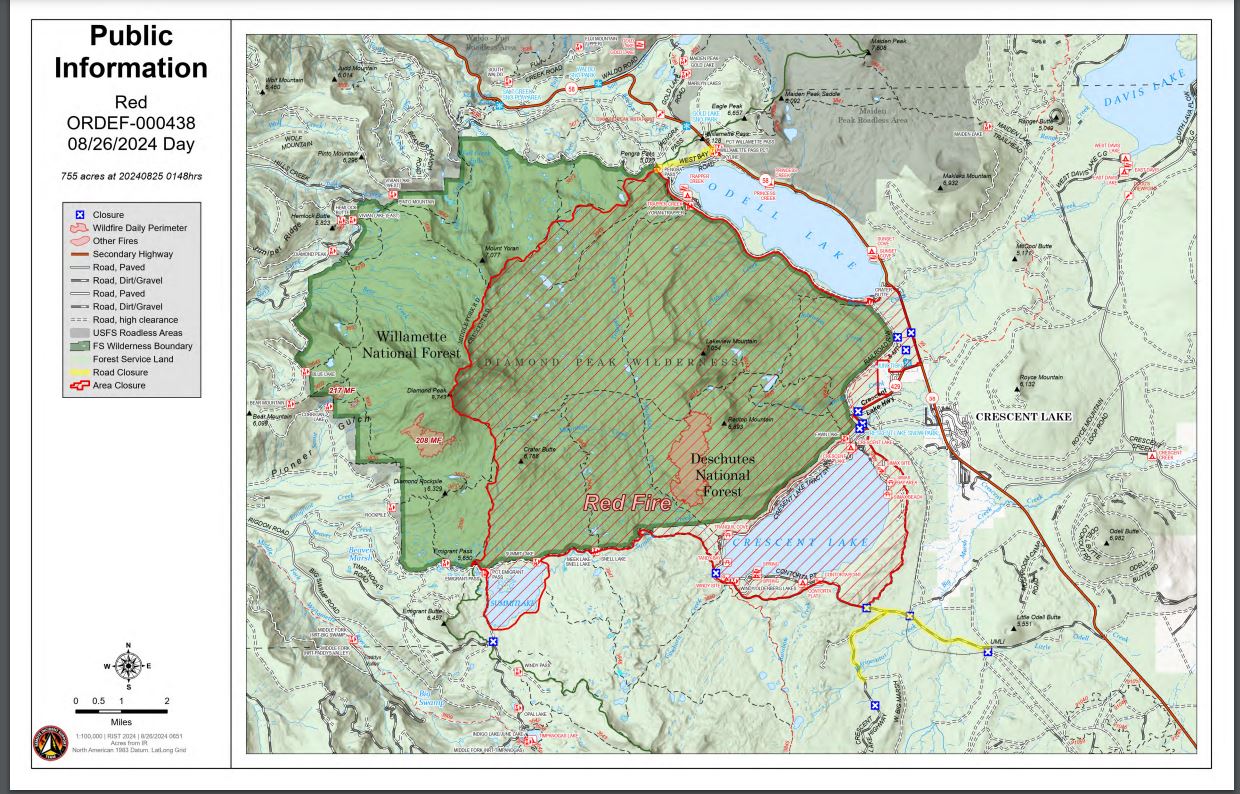
Size: 755 acres Location: 5 miles west of Crescent Lake Junction, OR County: Klamath
Start Date: July 17, 2024 Cause: Lightning Containment: 0% Total Personnel: 183
Activities – Fire personnel are wrapping up the shaded fuel break along the shore of Crescent Lake.
Crews are also removing wood chips from this area as well. Crews continued to make good progress
on the shaded fuel break between Crescent Lake and Summit Lake yesterday. Log trucks and other
heavy equipment are hauling the chips and logs out of the fire area again today.
Incident Strategy – The Red Fire is burning on the southwest slope of Redtop Mountain within the
Diamond Peak Wilderness on the Deschutes National Forest. An assessment by the initial attack
incident commander and local fire managers determined the risk to responders was too great to
continue with direct attack due to firefighter safety concerns including the remote location, a lack of
escape routes and safety zones, and snag hazards. Currently, a full suppression strategy is being
implemented utilizing shaded fuel breaks. Fire managers are continually reevaluating the safest, most
effective suppression strategy based on changing weather, fuel conditions, and fire behavior.
Firefighter and public safety remain the management team’s highest priority in managing this fire.
Closures – To provide for the safety of our staff, equipment operators, and public the Deschutes
National Forest emergency closure around Crescent Lake and in Diamond Peak Wilderness is still in
effect, include these areas: Forest Service Road 60 is closed, and road guards have been posted for
public safety. More closure information is available at: https://www.fsa.gov/alerts/deschutes/alertsnotices/?
aid=89091
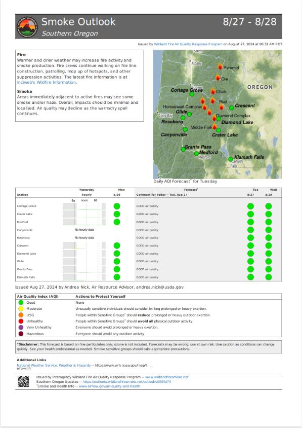
Weather and Smoke – Much warmer and drier conditions were experienced across the fire on
Monday under mostly clear skies. Highs were in the mid to upper 60s with minimum relative humidity
around 37 to 43 percent. Winds were generally terrain driven around 5 to 10 mph.
Evacuations – The WILDFIRE! Level 1 – BE READY to Evacuate notice issued by Klamath County
Emergency Management for Crescent Lake, Odell Lake, and Crescent Junction areas remains in
effect (INCENDIO FORESTAL! Nivel 1 - ESTÉ PREPARADO para evacuar de las siguientes zonas:
Crescent Lake, Odell Lake, Crescent Junction). Visit www.klamathcounty.org/300/emergencymanagement
for more information or to sign up for alerts.
Fire Restrictions – Stage 2 Public Use Fire Restrictions – which prohibit open fires, including in
developed campgrounds – remain in effect for the Deschutes National Forest. The Industrial Fire
Precaution Level is currently Level III “Partial Shutdown.” Visit
fs.usda.gov/detail/deschutes/home/?cid=stelprdb5297376 for more information.
Drone Restrictions – Aerial firefighting is suspended when unauthorized drones (UAS) are in the
area. Unauthorized drone use over a fire area poses serious risks to fire personnel and the
effectiveness of wildfire suppression operations. If you fly, we can’t.