
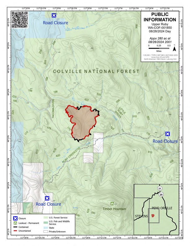
Upper Ruby Fire Daily Update 08 28 2024
Related Incident:
Publication Type: News
Upper Ruby Fire Daily Update
August 28, 2024
Quick Facts
Containment: 39%
Fire Perimeter: 280 acres
Initial Start: 08/20/24
Location: Ruby Creek Drainage - approximately 16 miles northwest of Cusick, WA
Hazards: hot ash pits, timber snags, bees, and narrow roads
Values at Risk: Private residences, ongoing timber sales
Cause: Undetermined
Personnel: 262
Structures destroyed: 0 Evacuations: None
Road Closures: Ruby Creek Road (5.5 miles in from Hwy 20), Tacoma Creek Rd (about 11 miles west of Hwy 20), and Tacoma Divide Road (about 4 miles south of Hwy 20)
Ione, WA
PUBLIC AND FIREFIGHTER SAFETY IS THE NUMBER ONE PRIORITY.
The Upper Ruby Fire is in central Pend Oreille County approximately 16 miles northwest of Cusick, WA. It isburning in fuels remaining on the ground following logging activities and in heavily forested areas.
OPERATIONS: Yesterday, 10 crews, 9 engines, 7 water tenders, and 3 pieces of heavy equipment continued mopping up along the fire perimeter to strengthen control lines. This included digging by hand, using hoses to apply water to the ground, and using heavy equipment. Portable handheld infrared technology was used to identify heat near the fire perimeter. Crews mopped up at least 33 feet from the fire perimeter with some areas up to 100 feet. Containment was increased to 39%.
At least 8 medical personnel were staged throughout the fire to support fire personnel.
TODAY: crews will continue to mop up along the fire perimeter. Portable handheld infrared technology will continue to be used to identify heat near the fire perimeter so that crews can work to extinguish those areas.
HAZARDS: Hazards to firefighters include hot ash pits, unstable footing, fire-weakened and standing dead trees (snags) and a very high population of ground nesting bees.
WEATHER: Partly cloudy in the morning becoming mostly sunny in the afternoon. High temperature around 63 degrees. Westerly winds 4 to 6 mph with gusts to 14 mph in the afternoon.
Inciweb: https://inciweb.wildfire.gov/incident-information/wacof-upper-ruby
Facebook: https://www.facebook.com/newfireinfo
Phone: 509-990-6218 (hours 8 am – 8 pm)

WYDOT Expects Short Delays on Hwy 26 08 28 2024
Related Incident:
Publication Type: Announcement
WYDOT UPDATE:
The Wyoming Department of Transportation will be conducting traffic control on U.S. Highway 26/287 today while fire crews preemptively cut down hazardous trees along the highway at several locations between mile posts 27 and 31. Motorists should expect intermittent delays during this tree-removal work. If these trees were to catch fire, embers from them could blow across the highway possibly allowing the fire to continue to move north. As these trees burn they could fall onto the highway unexpectedly, creating a dangerous situation for the firefighters and public that might be travelling on the highway.
See our Facebook Page: https://www.facebook.com/ExcellenceInTransportation/
Coffee Pot Fire Update 08 28 2024
Related Incident: Coffee Pot Fire
Publication Type: News
Unified Command: CIIMT5 & CAL FIRE
Fire Size: 4,552 acres
Percent Contained: 0%
Personnel: 1,312
Cause: Lightning
Start Date: Saturday, August 3, 2024, at 10:05 AM
Location: Southeast of Three Rivers, CA
EVACUATION WARNING: An Evacuation WARNING has been issued for the area’s TLC-E128-A and TLC-E127-B, north of South Fork Drive, south of Skyline Drive, east of Skyline Drive, and west of South Fork Drive. Zones TLC-E094-B and TLC-E128-B will remain in a WARNING. To find out if you live in an evacuation warning zone, visit protect.genasys.com. An Evacuation Warning means you should prepare to evacuate the area should the fire approach your home. Please stay clear and out of the areas affected by the fire. If there is an emergency, please dial 911. For more information on evacuations, alert notifications, and zone information, please visit tularecounty.ca.gov/emergencies.
FIRE INFORMATION: A Public Information Officer will be at the Three Rivers Village Market daily from 10:30 AM to 4:00 PM to provide fire information and answer questions.
CURRENT SITUATION: The Coffee Pot Fire increased by 874 acres, backing slowly toward the South Fork of the Kaweah River at the Scratch Creek junction. In the northeast, low intensity fire backed into the Salt Creek Grove of giant sequoias. Sixty-five percent of primary control lines have been constructed. Crews also continued clearing brush along Mineral King Road and conducted a low-intensity backing fire to remove vegetation in the Eden Creek Grove of giant sequoias. Three, 10-person Fire Use Modules constructed indirect control lines on the eastern flank, reaching Homers Nose at the fire’s edge.
Today, firefighters will continue improving indirect control lines on the south and west flanks for a strategic firing operation. On the south flank, the fire has moved towards the indirect control line at the South Fork of the Kaweah River and is burning lighter fuels. To contain the fire, firefighters are constructing control lines directly at the fire’s edge near Scratch Creek. The Fire Use Modules are building indirect control lines on the east flank along Horse Creek toward the East Fork of the Kaweah River, with the objective of constructing line to Mineral King Road.
WEATHER: High pressure building in the area will bring continued warming and drying today. Skies will be sunny with haze and smoke. Winds will be diurnal and terrain-driven today and tonight. They will be out of the northeast in the early morning, with southwest winds developing mid-morning and gusts over ridges in the afternoon. The weather tomorrow is expected to continue warming and drying.
SMOKE IMPACTS: Smoke impacts are expected to be similar to yesterday, with warm, dry and relatively calm weather producing more smoke with weak dispersion. Conditions should improve mid-day for most areas, as smoke lifts out of valleys, with the exception of the Mineral King zone which will see air quality levels at UNHEALTHY to VERY UNHEALTHY during the afternoon and evening. As of this morning, the highest concentrations are between Three Rivers and Hammond, and south of the fire towards Springville. These zones can expect to see conditions improve to MODERATE, as smoke lifts out of the valley during the day, returning to UNHEALTHY FOR SENSITIVE GROUPS later this evening and UNHEALTHY overnight. We are expecting to see MODERATE levels continue in the valley near Porterville and Visalia today, likely increasing to UNHEALTHY FOR SENSITIVE GROUPS overnight, especially closer to the foothills. For more information on current wildfire smoke impacts in your community, please visit AirNow.gov or fire.airnow.gov.
HIGHWAY AND ROAD IMPACTS: Highway 198, Mineral King Road, and Generals Highway in Sequoia and Kings Canyon National Parks are open. Due to heavy equipment and personnel working on Mineral King Road, expect 30-minute delays or longer. Please plan accordingly. Additional law enforcement will be patrolling the area through the holiday weekend. Visitors should exercise extreme caution, stay alert, and drive slowly to keep themselves and fire crews safe.
BLM AND PARK CLOSURES: The portion of South Fork Drive within Sequoia and Kings Canyon National Parks and trails accessed from the road, including the Ladyug and Garfield Grove Trails, are closed. Park closure information is available online at nps.gov/seki. The Bureau of Land Management has also issued a closure of the Case Mountain Extensive Recreation Management Area at blm.gov/press-release.
PUBLIC NOTICE: Wildfires are a no-fly zone for unauthorized aircraft, including drones. If you fly, we can’t. For more information, visit knowbeforeyoufly.org.
Sharrott Creek Fire Daily Update 08 28 2024
Related Incident:
Publication Type: News
Video Update: https://fb.watch/ugnY16k7ZW/
Northern Rockies Team 3, Incident Commander Mike Behrens
Location: One mile west of Stevensville, Montana in Ravalli County
Start Date: 8/23/2024
Cause: Lightning
Size: 1,130 Acres
Completion/Containment: 0 percent
Resources assigned: 388 people
KEY MESSAGES
- We encourage non-fire personnel to stay out of the evacuated neighborhoods so that firefighters can safely do their jobs without interference.
Current Status
Strong downhill winds preceding the cold front caused some spotting ahead of the eastern edge of the main fire yesterday. Helicopters dropped water to assist firefighters in catching that spot near the southeast corner of the fire perimeter. The Helena Hotshots along with an Alaska module worked with bulldozers last night to catch an approximately 15-acre slopover on the southeast corner during a very strong wind event.
Crews today will mop and hold the 739 Road. The Salmon River Hotshot crew and bulldozers will build direct line along the northern perimeter just south of Larson Creek. Smith River Hotshots are also building indirect line on the south side, tying into switchbacks on the St. Mary’s Peak Road above Silverthorne Creek. Several Type 6 (wildland urban interface) fire engines will be employed to assist with structure protection in the neighborhoods near the eastern edge of the fire.
Crews are holding the eastern edge and patrolling the affected neighborhoods during night shifts.
There are temporary flight restrictions (TFR) over the fire area west of Highway 93 from Bass Creek to Big Creek.
Weather and Fire Behavior
The cold front ushered in cooler temperatures and the high today will be 66° F with 35-40 percent relative humidity over the fire area. Winds will generally be from the west with gusts to 30 mph on ridgetops. Fire behavior today will be dominated by flanking, backing and isolated small group torching.
Smoke
For the current smoke reports, visit www.fire.airnow.gov/
EVACUATIONS, RESTRICTIONS, CLOSURES
The Ravalli County Sheriff’s Office has issued evacuation orders and warnings for neighborhoods in the vicinity of the Sharrott Creek Fire. For the latest status and an evacuation map, visit the Ravalli Co. Sheriff’s Office website: https://ravalli.us A Red Cross evacuation shelter is still available at the LDS Church in Stevensville at 100 Middle Burnt Fork Road. Evacuation questions can be directed to the Ravalli County Emergency Operations Center at 406-375-6650.
For the safety of firefighting pilots, do not fly unmanned aerial systems (drones) in the fire area.
Borel Fire Closure Forest Order No 05132422 08 28 2024
Related Incident: Borel Fire
Publication Type: Closures
Forest Order No. 0513-24-22
USDA FOREST SERVICE
PACIFIC SOUTHWEST REGION
SEQUOIA NATIONAL FOREST
Borel Fire Area, Trails, and Roads Closure
Pursuant to 16 U.S.C. § 551 and 36 C.F.R. § 261.50(a) and (b), and to provide for public safety, the following acts are prohibited within the Kern River Ranger District of the Sequoia National Forest. This order is effective from August 28, 2024, through September 30, 2024.
- Going into or being upon any National Forest System lands within the Borel Fire Closure Area, as described in Exhibit A and shown on the attached map. 36 C.F.R. § 261.52(e).
- Being on any National Forest System trails within the Borel Fire Closure Area, as described in Exhibit A and shown on the attached map. 36 C.F.R. § 261.55(a).
- Being on any National Forest System roads within the Borel Fire Closure Area, except Sandy Flat Road and its spur roads (Forest Roads Nos. 27S06, 27S06A, and 27S06B), as described in Exhibit A and shown on the attached map. 36 C.F.R § 261.54(e).
- Entering or using any Developed Recreation Sites within the Borel Fire Closure Area, except Sandy Flat, as described in Exhibit A and shown on the attached map. 36 C.F.R. § 261.58(b)
Pursuant to 36 C.F.R. § 261.50(e), the following persons are exempt from this Order:
- Persons with Forest Service Permit No. FS-7700-48 (Permit for Use of Roads, Trails, or Areas Restricted by Regulation or Order), specifically exempting them from this Order.
- Any Federal, State, or local officer, or member of an organized rescue or firefighting force in the performance of an official duty.
- Owners or lessees of land in the area, to the extent necessary to access their property. These prohibitions are in addition to the general prohibitions in 36 C.F.R. Part 261, Subpart A.
A violation of these prohibitions is punishable by a fine of not more than $5,000 for an individual or
$10,000 for an organization, or imprisonment for not more than 6 months, or both. 16 U.S.C. § 551 and 18 U.S.C. §§ 3559, 3571, and 3581.
Executed in Porterville, California, this 27th day of August, 2024.
ANTHONY EDWARDS
Forest Supervisor Sequoia National Forest
Exhibit A
The Borel Fire Closure Area begins at the intersection of the Sequoia National Forest Boundary and Highway 178 in Section 32, Township 28 South, Range 30 East, Mount Diablo Base and Meridian, then continues north and east approximately 14.5 miles along the south side of Highway 178 to its intersection with the Kern River in Section 26, T. 27 S., R. 31 E., MDB&M, then continues northeast approximately 7.5 along the south side of the Kern River to its intersection with Highway 178 in Section 10, T. 27 S., R. 32 E., MDB&M, then continues northeast approximately 1.5 miles along the south side of Highway 178 to its intersection with the Forest Boundary in Section 11, then continues east and then southwest approximately 32 miles along the Forest Boundary back to the starting point.
Williams Mine Fire Update 08 28 2024
Related Incident: Williams Mine Fire-GPNF
Publication Type: News
Williams Mine Fire Update for Wednesday, August 28, 2024
KEY MESSAGES:
A local Type 3 Incident Management Team assumed command of the Williams Mine Fire as of 6 p.m. yesterday. This team will continue the work done by Northwest Team 13 to secure the fire, keeping it from spreading to the south and east. The focus will continue to be achieving incident objectives in a safe and efficient manner.
CURRENT STATUS:
Crews continue patrolling and monitoring the fire, watching for smoke and other indications of heat near the established control lines. Yesterday’s dry, windy weather caused an increase in fire activity, nearly all of it in the interior of the fire. Unburned pockets of brush and other fuels will continue to burn as they dry out after the recent rain and high humidity.
To the west, the shaded fuel break on FS Rd 23 is nearing completion. About 16 pieces of heavy equipment are working on and along the road, including feller-bunchers, excavators, log trucks, and large dump trucks. They are cutting, loading, and hauling small trees, branches, and other woody debris, and piling it in a safe location away from the Williams Mine Fire. Masticators and chippers are also being used to further reduce the fuels along Rd 23. The Gifford Pinchot National Forest is working to reopen part of the FS Rd 23 not impacted by this shaded fuel break work, to provide an alternate route between Trout Lake and Randle.
WEATHER / FIRE BEHAVIOR:
A dry cold frontal passage on Tuesday brought strong winds and drier air to the region, but cooler temperatures prevented relative humidity (RH) values from dropping to critical levels. Beginning today, afternoon RH values are expected to drop below 30 percent each afternoon through Sunday while overnight humidity recoveries will be poor. This is expected to cause an increase in fire activity. Smoke may be visible from local communities.
SAFETY AND CLOSURES:
The Confederated Tribes and Bands of the Yakama Nation, Tract D Recreation Area is currently closed, please see Yakama Tract D Road Closure for more information. The FS 23 and FS 25 roads are closed, see the Williams Mine Area and Road Closure for more details. The Pacific Crest Trail (PCT) is closed from the PCT's intersection with FS 23 to Potato Hill. The current area closure spans the entire Mt. Adams Wilderness.
2620 Road Fire Final Update 08 28 2024
Related Incident: 2620 Road Fire
Publication Type: News
2620 Road Fire
Incident Commander: Dan Lacy
Email: 2024.2620Road@firenet.gov
Facebook: www.facebook.com/2620RoadFire2024
InciWeb: https://inciweb.wildfire.gov/incident-information/waolc-2620-road-fire
Update as of: August 28th – 31st, 2024
Estimated size: 398 acres
Containment: 100%
Start Date/Time: 8/14/2024 at 5:00 PM
Area of Origin: West of Brinnon, North of Duckabush Rd. on Mt. Jupiter
Cause: Undetermined
Structures Damaged: None
Update: As of August 28, 2024, the 2620 Road Fire containment is at 100% containment. The fire has now transitioned to a Type 4 Incident with reduced staffing.
This will be the last update for the 2620 Road Fire.
- Aerial operations will continue to fly in order to monitor the fire area looking for heat and hot spots
- Mop up and patrolling will continue throughout the fire area
- Hose lays will be moved as needed and then come off the mountain
- Road assessments will continue and grading or small repairs will begin
- Hand dug and machine firelines will have their berms softened or removed
- Flagging, marking, and other items will be removed
The Western Washington Type 3 Incident Management Team and the Georgia Forestry Commission Type 3 Incident Management Team are grateful for the outpouring of support and generosity from the community during this time. As we begin travelling back home, we look fondly on our time here and wish the best for everyone as life begins to get back to normal.
Air Restrictions: The Temporary Flight Restriction (TFR) has been lifted.
Weather: The weather pattern will be warming into the 80’s this week, and the chance of rain continues to lesson, however, the seasonal chance of afternoon showers will continue.
Forest Closures: Olympic National Forest closures are located at www.fs.usda.gov and Olympic National Forest – Alert and Closures web page
Pioneer Fire Update 08 28 2024
Related Incident:
Publication Type: News
Pioneer Fire Update
August 28, 2024
Quick Facts
Size: 38,735 acres
Start Date: June 8, 2024
Location: 31 miles NW of Chelan, WA
Containment: 23%
Personnel: 401
Cause: Under investigation
Resources Assigned: 4 crews, 6 helicopters, 5 engines, 13 water tenders, 7 heavy equipment
This will be the final daily update for the Pioneer Fire unless fire activity or conditions change.
CURRENT SITUATION: Firefighters have been successful protecting private residences and other infrastructure along the lakeshore and within the Stehekin area and there has been little to no growth and minimal fire activity over the last two weeks. Yesterday firefighters completed backhaul of excess equipment along the lakeshore and contingency lines south of the fire. Fire crews also continued repairing fireline in the Little Boulder Creek area. Firefighters monitoring the fire’s edge identified some smoke from smoldering logs in the Boulder Creek drainage, interior to the fire. With warmer and drier weather conditions forecasted through the week, additional smoke is likely as heavier fuels, like downed logs, slowly burn out. There were no aircraft operations yesterday due to high winds over the fire area.
TODAY’S ACTIVITIES: Firefighters will continue to patrol the firelines near Stehekin and check for any hot spots that may threaten containment lines. Suppression repair activities will continue, and crews will work to complete remaining brush piling and repair of roads damaged by fire-related traffic. Aircraft will support operations with reconnaissance flights to check for fire activity and helicopters will be used to backhaul excess equipment from remote locations. Firefighters are prepared to support initial attack of new fires.
Today is the last day of the Incident Command Post in Manson. Management of the Pioneer Fire from Safety Harbor north will transfer to a smaller Type 3 incident management organization based in Stehekin at 5:00 p.m. today. Management of the Pioneer Fire from Safety Harbor south will transfer back to the Okanogan-Wenatchee National Forest at 5:00 p.m. today.
WEATHER: Warmer and drier weather conditions will arrive today and linger through the weekend. Temperatures will be in the high 70s today and mid 80's tomorrow. Wind speeds have moderated since yesterday, with mostly diurnal terrain-driven winds forecast for the fire area.
EVACUATIONS: To view the current evacuation levels, please visit the Chelan County Emergency Management Facebook page at facebook.com/CCSOEM or view the interactive map at: https://chelangis.maps.arcgis.com/apps/instant/media/index.html?appid=ca1e19e4123b4002a9fb176b25434e03/.
CLOSURES: Many trails and campgrounds remain closed. Check the current closures for the North Cascades National Park: https://go.nps.gov/fireclosures and Okanogan-Wenatchee National Forest: https://www.fs.usda.gov/alerts/okawen/alerts-notices before traveling to these areas. The Pacific Crest Trail is closed in areas across Washington due to multiple wildfires. For more information, please visit: closures.pcta.org/.
InciWeb: https://inciweb.wildfire.gov/incident-information/wases-pioneer
Facebook: https://www.facebook.com/profile.php?id=61560760893080
Fire Information Line: 541-861-5808, 8 a.m. to 8 p.m.
Email: 2024.pioneer@firenet.gov
Settings - change map background and toggle additional layers
Filter - control incident types displayed on map.
Zoom to your location
Reset map zoom and position
Could not determine your location.
Show Legend
 Wildfire
 Prescribed Fire
 Burned Area
Response
Burned Area
Response Other
Other
Marsh Creek
Unit Information
Incident Contacts
August 28 2024 Whisky Creek and Sandstone Fires Daily Update 08 28 2024
Related Incident: Whisky Creek FireSandstone Fire
Publication Type: News
Whisky Creek Size: 2,084 acres | Reported Date: July 20 | Cause: Human, Under Investigation | Containment: 24%
Sandstone Size: 702 acres | Reported Date: August 5 | Cause: Lightning | Containment: 74%
Total Resources: 550 | Hand Crews: 10 | Engines: 9 | Dozers: 2 | Other Heavy Equipment: 17 | Helicopters: 4
(Odell, Ore.) -- Fire suppression efforts continue on the Whisky Creek Fire, 6 miles southeast of Cascade Locks, Ore. and the Sandstone and Blister Creek Fires, 9 miles southwest of Ripplebrook, Ore. The fires are burning in steep and rugged terrain on the Mt. Hood National Forest where rolling debris and fire-weakened trees challenge firefighting efforts. Firefighter and public safety remain the incident’s top priority.
During a wildfire, incident managers identify primary and contingency lines designed to protect communities, infrastructure and other critical values at risk. Primary lines are chosen based on the highest probability of success in halting fire spread while minimizing risk to firefighters. Contingency lines serve as a backup should fire breach primary lines. In areas with complex terrain or where unconsumed fuels remain within constructed or identified lines, full containment may not be possible until a season-ending event, such as a significant rain or snowfall with prolonged cool temperatures. Continuous monitoring and regular evaluation of strategies and tactics are essential until fire managers can be reasonably certain that the fire no longer poses a threat.
Whisky Creek: Yesterday, due to slick conditions following early morning rain showers, crews were unable to complete the line along Tomlike Mountain Ridge. Mastication was completed on contingency lines to the southeast and crews continue to improve lines in these areas. Firefighters patrolled and monitored the fire’s eastern containment lines while rehabilitation efforts, in coordination with Resource Advisors, were focused on areas where active fire suppression efforts were not in progress. Today, as conditions allow, crews will attempt to complete the Tomlike Mountain ridge handline, connecting it to the fire’s southwestern edge. Patrols and suppression repair along the eastern perimeter will continue.
Sandstone & Blister Creek: Yesterday, on the Blister Creek Fire, a Sikorsky 61 helicopter delivered approximately 6,250 gallons of water to the uncontained southern perimeter using a larger, heavier bucket for more precise water application. Mastication and grading continued on roadways around the fires to improve access to and from both incidents. Today, chipping operations on Forest Road 70 will continue. Ground crews and aerial resources will monitor and provide support to the Blister Creek Fire as needed.
Weather and Fire Behavior: Fair weather is forecast for today with a shift to easterly winds in the afternoon, bringing increased temperatures and lower humidities. However, fuels are retaining moisture after recent rainfall and fire behavior is expected to be minimal.
Closures: The Mt. Hood National Forest, the Columbia River Gorge National Scenic Area and Hood River County closure information can be found by scanning the QR code or following the link below. Closures are in place for the safety of the public and fire crews.
Safety: The public plays an important role in preventing the next wildfire; use caution with all ignition sources. For prevention tips visit, https://keeporegongreen.org. Fire restrictions are in place within the Mt. Hood National Forest. More information can be found at: https://www.fs.usda.gov/main/mthood/fire. A Temporary Flight Restriction (TFR) is in place over both fire areas.
Smoke: Air quality conditions are forecast to be good for both fire areas. For more information on smoke conditions in your area, go to: www.AirNow.gov.
For further information about the Whisky Creek and Sandstone Fires, see the following resources:
Email: 2024.whiskycreek@firenet.gov or 2024.sandstone.or@firenet.gov
Phone: 541-208-1743, 8 a.m. – 8 p.m.
Web: Scan the QR code or go to https://linktr.ee/whisky_creek.2024