
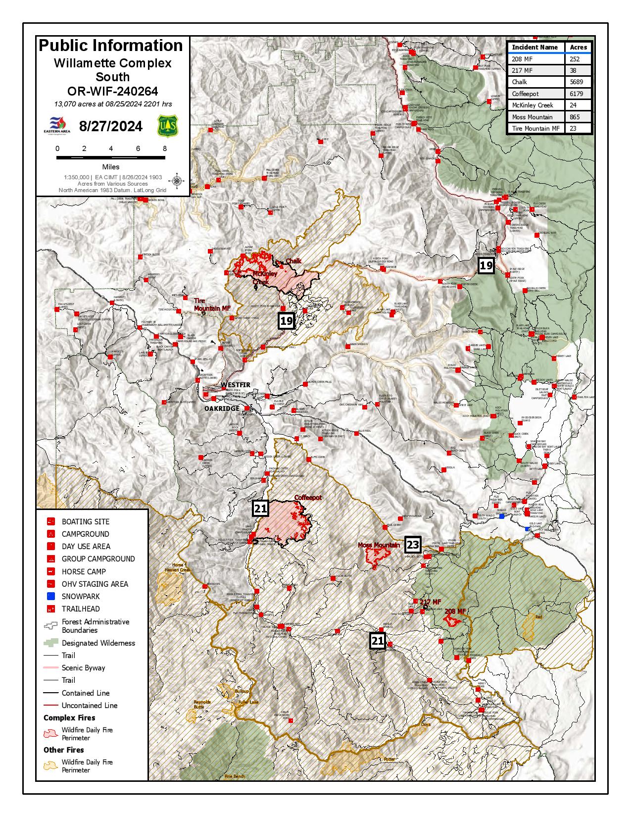
Willamette Complex South Daily Update for Tuesday 08 27 2024
Related Incident: Willamette Complex Fires - South
Publication Type: News
Willamette Complex South Update
Chalk, Coffeepot, McKinley, Moss Mountain, Tire Mountain, 208, and 217 Fires
Online: https://inciweb.wildfire.gov/orwif-willamette-complex-fires-south
Facebook: https://www.facebook.com/WillametteComplexFires/
Email: 2024.willamettecomplex@firenet.gov
Fire Information Line: 541-208-1742
Tuesday, August 27, 2024
Total Willamette Complex South Personnel: 575
Total Willamette Complex South Acres: 13,070
Resources*: 2 Type 1 Hotshot Crews, 10 Type 2 Crews, 1 Type 2 Initial Attack Crew, 1 Helicopter, 19 Engines, 6 Dozers, 13 Masticators, 5 Skid Steer, and 4 Feller Bunchers (* The numbers include Pyramid Fire resources)
Fire Cause: Lightning
Summary
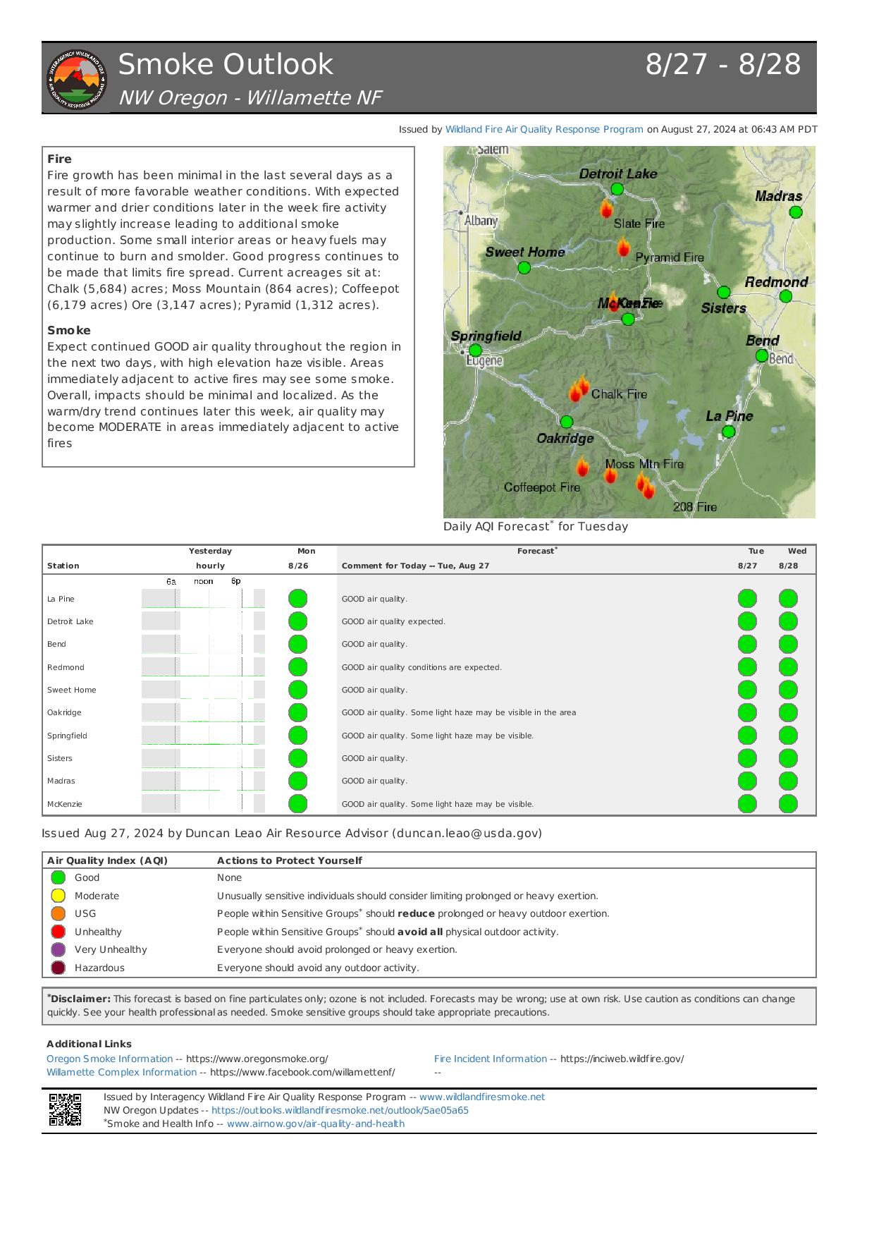
Firefighters continue to make progress with the improved weather conditions. On Chalk Mountain, pockets of heat are still notable along the northwest side of the fire, where fire crews are focusing efforts to strengthen the control line and address hotspots and snags as they are discovered. Yesterday, on Moss Mountain, helicopters provided water bucket drops, mainly along the south side of the fire near the 2120 road. Fire crews also worked on removing fire-weakened trees and snags along the 2300 road. Helicopters will be available again today and working with the hotshot crews along all sides of the fire to provide water bucket drops to cool down lingering pockets of heat.
Chalk Fire (5,689 acres, 66% containment)
Fire crews continue to monitor and improve the containment lines on the south, east, and north sides of the fire. On the west side, crews are continuing to strengthen and deepen completed control lines from the main body of the fire, west along 1912 road and tying back into the main body of the fire on 1925 road and addressing fire-weakened trees and snags and mopping up hot spots as they are discovered.
Moss Mountain Fire (865 acres, 0% containment)
Hotshot crews are working along the fire's south side to secure Forest Service Road 2120, scouting out the Hills Creek area to observe any possible fire movement from the ground level and looking for potential routes to implement a control line. Work on the indirect tactics along Forest Roads 2210 and 23, involving heavy equipment to remove vegetation, woody debris and brush along the mountain road system, continues. This work results in an effective fuel break. Crews continue to prep dozer lines along the north side of the fire.
208 Fire (252 acres, 0% containment)
The 208 Fire is being monitored and patrolled in the wilderness using aerial resources. When necessary, helicopters are using bucket drops to keep the fire in check.
217 Fire (38 acres, 100% contained), Tire Mountain Fire (23 acres, 100% contained), McKinley Fire (24 acres, 100% contained), Coffeepot Fire (6,179 acres, 100% contained)
The 217, Tire Mountain, McKinley, and Coffeepot fires are 100% contained and are patrolled regularly. Fire crews continue improving contingency lines established around the Coffeepot Fire.
Weather and Fire Behavior
A weak storm system will arrive today, bringing slightly cooler temperatures. Highs will be in the low 60s with 53% relative humidity. The wind will be out of the northwest, seven mph, gusting up to 16 mph. Warmer and breezier conditions return later in the week.
Closures and Fire Restrictions
- For specific closure information, visit tinyurl.com/WillFireClosures2024
- For current fire restrictions, visit tinyurl.com/WillFireRestrictions2024
- Temporary Flight Restrictions (TFR): tfr.faa.gov for up-to-date areas. Wildfires are a no-fly zone for unauthorized aircraft, including drones. For more information, visit knowbeforeyoufly.org.
Coffee Pot Fire Update 08 27 2024
Related Incident: Coffee Pot Fire
Publication Type: News
Unified Command: CIIMT5 & CAL FIRE
Fire Size: 3,678
Percent Contained: 0%
Personnel: 1,142
Cause: Lightning
Start Date: Saturday, August 3, 2024, at 10:05 AM
Location: Southeast of Three Rivers, CA
NEW EVACUATION WARNING: An Evacuation WARNING has been issued for the area’s TLC-E128-A and TLC-E127-B, north of South Fork Drive, south of Skyline Drive, east of Skyline Drive, and west of South Fork Drive. Zones TLC-E094-B and TLC-E128-B will remain in a WARNING. To find out if you live in an evacuation warning zone, visit protect.genasys.com.
An Evacuation Warning means you should prepare to evacuate the area should the fire approach your home. Please stay clear and out of the areas affected by the fire. If there is an emergency, please dial 911. For more information on evacuations, alert notifications, and zone information, please visit tularecounty.ca.gov/emergencies.
FIRE INFORMATION: A Public Information Officer will be at the Three Rivers Village Market daily from 10:30 AM to 4:00 PM to provide fire information and answer questions. If you were unable to attend or view the public meeting last night it is available on Sequoia and Kings Canyon National Parks Facebook @SequoiaKingsNPS and YouTube channel @sequoiaandkingscanyonnps5018.
CURRENT SITUATION: The Coffee Pot Fire increased by 244 acres. Sixty-three percent of primary and indirect control lines totaling nearly 18 miles have been constructed. Indirect control lines between South Fork Drive and Cinnamon Gap, Cinnamon Gap to the top of Case Mountain, the Tower Check to Mineral King Road, and along South Fork Drive have been completed. Hoses, pumps, and storage tanks were placed along the indirect control lines to assist with fire operations. Firefighters also removed brush and chipped materials along Mineral King Road and conducted a low-intensity backing fire to remove vegetation in the Eden Creek grove of Giant Sequoias. Three, 10-person Fire Use Modules began implementing indirect control lines on the eastern flank, heading toward Homers Nose.
Now that we have established indirect control lines on the southern and western flanks, we are shifting our focus to a direct attack to contain the fire and protect the adjacent communities. If all conditions are favorable, crews will initiate a strategic firing operation using a backing fire to control the intensity and rate of spread of the fire. Beginning tonight, crews and engines will work around the clock to support the firing operation. The strategic firing operation will start near Case Mountain and continue to South Fork Drive, employing drip torches and targeted aerial ignition. We anticipate that this operation will last multiple days.
WEATHER: High pressure building in the area will bring continued warming and drying today. Skies will be sunny, with haze and smoke. Diurnal winds will be out of the northeast in the early morning, shifting out of the west southwest by mid-morning, and gusting over ridges in the afternoon. Temperatures should peak tomorrow, slightly cooling later in the week.
SMOKE IMPACTS: Conditions have improved for most of the area since yesterday. The exception is near Springville and the surrounding area immediately south of the fire, which is seeing air quality between UNHEALTHY FOR SENSITIVE GROUPS and UNHEALTHY. This should improve to MODERATE during the day, but will likely return to UNHEALTHY overnight, with conditions that are UNSAFE FOR SENSITIVE GROUPS likely in Porterville. Smoke has settled back in to the Three Rivers area, with levels ranging from MODERATE to UNHEALTHY FOR SENSITIVE GROUPS, as of this morning. We should see this smoke disperse during the day, recovering to MODERATE this afternoon before returning to UNHEALTHY overnight. Light northerly winds have kept the air clear farther north of the fire, but we will likely see levels return to UNSAFE FOR SENSITIVE GROUPS in the Giant Forest area tonight. The Mineral King area will likely see levels rise to UNSAFE FOR SENSITIVE GROUPS this afternoon, improving overnight. For more information on current wildfire smoke impacts in your community, please visit AirNow.gov or fire.airnow.gov.
HIGHWAY AND ROAD IMPACTS: Highway 198, Mineral King Road, and Generals Highway in Sequoia and Kings Canyon National Parks are open. Due to heavy equipment and personnel working on Mineral King Road, expect 30-minute delays or longer. Please plan accordingly. Visitors should exercise extreme caution, stay alert, and drive slowly to keep themselves and fire crews safe.
BLM AND PARK CLOSURES: The portion of South Fork Drive within Sequoia and Kings Canyon National Parks and trails accessed from the road, including the Lady Bug and Garfield Grove Trails, are closed. Park closure information is available online at nps.gov/seki. The Bureau of Land Management has also issued a closure of the Case Mountain Extensive Recreation Management Area at blm.gov/press-release.
PUBLIC NOTICE: Wildfires are a no-fly zone for unauthorized aircraft, including drones. If you fly, we can’t. For more information, visit knowbeforeyoufly.org.
Pioneer Fire Update 08 27 2024
Related Incident:
Publication Type: News
Pioneer Fire Update
August 27, 2024
Quick Facts
Size: 38,735 acres
Start Date: June 8, 2024
Location: 31 miles NW of Chelan, WA
Containment: 23%
Personnel: 418
Cause: Under investigation
Resources Assigned: 8 crews, 6 helicopters, 8 engines, 15 water tenders, 8 heavy equipment
CURRENT SITUATION: Firefighters backhauled equipment and hose from Moore Point south along the lakeshore to the southern end of the fire. Crews pulled hose from the Safety Harbor area and contingency lines south of the fire. Resources in the Stehekin area placed concentrations of removed vegetation into piles. They continued to monitor fire activity in the Boulder Creek and Little Boulder Creek drainages. Mastication and road repair work is ongoing in the Cooper’s Ridge area south of the fire.
Stehekin is now open to visitors. Many fire-related hazards remain in the area and services may be limited or altered. Additionally, many trails and campgrounds remain closed due to these hazards. Visitors should confirm available services before traveling.
TODAY’S ACTIVITIES: Today firefighters will patrol and monitor fire behavior to ensure the fire stays within the existing footprint. Warming temperatures later this week may lead to increased isolated heat and smoke visible within the fire perimeter. While wind is forecasted over the fire area today, vegetation has retained significant moisture from last weekend’s storms and predicted wind directions suggest that any rekindled embers should remain interior of the fire perimeter. In the Little Boulder Creek area, crews will start repairing the suppression line to decrease the risk of soil erosion. Aircraft will support ongoing backhaul missions and provide aerial patrols of the fire. Resources south of the fire near Manson are working on road repair from fire traffic. As fire activity decreases, excess equipment and resources are being released from the incident. Firefighters remain ready to assist with potential new fire starts.
WEATHER: Breezy conditions are expected today with gusts up to 30 MPH on exposed ridges and along Lake Chelan. Winds will taper off throughout the day with a warming and drying trend starting Wednesday.
EVACUATIONS: To view the current evacuation levels, please visit the Chelan County Emergency Management Facebook page at facebook.com/CCSOEM or view the https://chelangis.maps.arcgis.com/apps/instant/media/index.html?appid=ca1e19e4123b4002a9fb176b25434e03/.
CLOSURES: Many trails and campgrounds remain closed. Check the current closures for the North Cascades National Park: https://go.nps.gov/fireclosures and Okanogan-Wenatchee National Forest: https://www.fs.usda.gov/alerts/okawen/alerts-notices before traveling to these areas. Campfires are prohibited. The Pacific Crest Trail is closed in areas across Washington due to multiple wildfires. For more information, please visit: closures.pcta.org/. There is a Temporary Flight Restriction (TFR) in place over the fire: tfr.faa.gov/save_pages/detail_4_2248.html. Unauthorized drone activity is prohibited under the TFR.
InciWeb: https://inciweb.wildfire.gov/incident-information/wases-pioneer
Facebook: https://www.facebook.com/profile.php?id=61560760893080
Fire Information Line: 541-861-5808, 8 a.m. to 8 p.m.
Email: 2024.pioneer@firenet.gov
Boise Fire Update August 27 2024 08 27 2024
Related Incident: 2024 Boise Fire
Publication Type: News
Headlines:
- A public meeting will be held at Forks of Salmon Community Club on Wednesday, August 28 at 1 p.m.
- Traffic control remains in place along the Salmon River Road between Butler Flat and Nordheimer Flat for the safety of firefighters and residents. Expect up to 30-minute delays. Incident personnel driving vehicles with more than two axels will not be allowed on the road.
- Fire information phone: 707 572-4860 or email at 2024.Boise@firenet.gov
- Get all your Boise Fire information in one mobile-friendly place! https://linktr.ee/2024boisefiresrf .
- Evacuations are in place for the Boise Fire for residents near the fire area in Humboldt County. For the most current evacuation information please visit the Boise Fire linktree or visit—
- Humboldt County: https://humboldtgov.org/356/Office-of-Emergency-Services
- Siskiyou County: https://www.co.siskiyou.ca.us/emergencyservices
Operational Update: Fire activity remained minimal overnight with no growth outside the current fire footprint. Infrared mapping identified a few interior heat sources in the eastern-southern parts of the fire, which crews will monitor. Today, crews will continue with previous work assignments, patrol the containment line on the west and north sides, and backhaul material and equipment. Suppression repair within the area is actively taking place by chipping material that resulted from the fire suppression effort. Along Nordheimer, crews line spiked overnight to ensure safety and have an early morning start of building and improving the direct line from China Creek to 10N23. Crews will be addressing the spot fire on the east side of China Creek. Resources continue to work on completing the indirect handline along the east side of the fire perimeter.
Weather and Fire Behavior: Dry conditions will continue, with temperatures rising slightly above normal. Relative humidity will drop to around 25-30%. During the day, winds will generally be terrain-driven but exposed ridges may experience west winds at 10 mph with gusts reaching up to 15 mph. As conditions continue to dry, fire activity may pick up.
Homestead Complex Fire Update 08 27 2024
Related Incident:
Publication Type: News
Homestead Complex Fire Update for Tuesday, August 27, 2024
No Man, Salmon 33, Horse Heaven Creek, Bullpup, Fuller Lake, Reynold’s Butte, Lost Bucket
Start date: July 19, 2024 | Location: Northeast of Glide, Oregon | Total Personnel: 908 Total Homestead Complex Fire size: 5,909 acres | Cause: Lightning | Containment: 50%
Summary
Favorable weather conditions on Monday allowed fire crews to make progress toward achieving containment goals. Fire managers are optimistic about Tuesday as well and expect to see continued good results from the work that is being done on the ground.
No Man (2,076 acres): Chipping operations are improving containment lines on the south side of the fire while improvements are being made to indirect lines on the east side.
Horse Heaven Creek Fire (2,296 ac.): Crews finished removing logs on the east side on Monday. Helicopter bucket drops were utilized yesterday and will continue today as needed to cool hot spots on the northern part of the fire. Firefighters are likely to finish a direct fireline on the northeast side on Tuesday.
Bullpup Fire (476 ac.) and Fuller Lake Fire (418 ac.): Hotshot crews are making excellent progress building a suppression line on the north side of the Bullpup Fire while favorable conditions are allowing firefighters on the Fuller Lake Fire to build direct fireline.
Salmon 33 (275 ac.) 100% contained on August 24, 2024.
Reynolds Butte Fire (334 ac): 100% contained on August 22, 2024.
Lost Bucket Fire (34 ac.): 100% contained on July 29, 2024.
Weather: High temperatures Tuesday will be in the mid to upper 60’s and relative humidities will range from the mid 40’s to around 50%. Winds will become NNW at 10 to15 mph with gusts to 25 mph.
Closures and Fire Restrictions
The closure order issued by Bureau of Land Management (BLM), Roseburg District, for portions of BLM land which border the Umpqua National Forest Emergency Fire Closure north of Steamboat remains in effect. The closure order can be viewed here: https://www.blm.gov/sites/default/files/docs/2024-07/orwa-fpo-rbg-072624.pdf
The Umpqua National Forest has Emergency Fire Closures in place impacting every district of the forest. https://www.fs.usda.gov/alerts/umpqua/alerts-notices.
There is a Temporary Flight Restriction (TFR) over the Homestead Complex Fire. Please remember, if you fly we can’t! If a drone or other aircraft enters the air space, all firefighting aviation equipment will be grounded.
Fire Information Line: 541-208-7100 (Staffed 8 a.m. to 8 p.m.)
Big Hollow Fire Update 08 27 2024
Related Incident:
Publication Type: News
Location: 13 miles west of Grant, MT Start Date: August 23, 2024
Cause: Undetermined Size: 3415 acres Containment: 40%
CURRENT STATUS + PLANNED ACTIONS:
Yesterday, crews continued containment efforts by securing all portions of the fire, but most work focused on the north and northwest side where heat is still left over and burning in a mixture of both standing and dead timber. Helicopters assisted crews by dropping water onto a small section of downed logs that flared up mid-day. After the initial flame front has passed, firefighters will locate areas of residual heat close to control lines and extinguish them by mixing water and dirt into the heat and by cutting up burning pieces of wood into smaller pieces so that they burn themselves out quicker. These actions are collectively referred to as “mop-up”. A few crews were assigned with carefully combing through the “green” or the unburned portions to locate spot fires outside of control lines.
Today, mop-up efforts will be continued. Crews will carefully evaluate tactics and prepare for the expected cold front passage described below.
Small amount of smoke from the fire can be expected as things continue to smolder in the fire area.
WEATHER AND FIRE BEHAVIOR:
Yesterday the fire area experienced light winds and cooler temperatures with a high in the 70’s. Fire behavior was minimal to moderate with an increase in activity concentrated in the northwest corner during the hottest part of the day.
A cold front will pass over the area today bringing lower relative humidities in the high teens to 20’s and an increase of winds out of the west with gusts up to 25-35 mph. Cooler temperatures are expected after the passage of the cold front.
EVACUATIONS AND CLOSURES
All evacuation orders have been lifted. The public has been asked to remain clear of the area to avoid impeding firefighting activity.
Diamond Complex and Middle Fork Daily Update 08 27 2024
Related Incident: Middle Fork Fire
Publication Type: News
Our primary mission on the Diamond Complex and Middle Fork Fire is to serve the public diligently. With the safety of the public and our firefighters in mind, we are committed to addressing the needs and concerns of your communities by managing and controlling the fires to keep your forests, parks, and natural areas safe and enjoyable. Utilizing safe, yet effective firefighting suppression methods, our goal is to help you return to enjoying the outdoors.
The Diamond Complex in the Umpqua National Forest consists of 32 fires totaling approximately 11,152 acres and is 72% contained. Twenty-eight of the 32 fires in the Diamond Complex are now 100 percent contained. The Emerson fire is 0.1 acres and has fireline around it.
The Middle Fork Fire in the northwest corner of Crater Lake National Park is 5,280 acres and is 2% contained. The fire is primarily burning within the 2015 National Creek and 2017 Spruce Lake fire scars. Throughout the fire area there is an extreme hazard to firefighters due to falling dead standing trees remaining from the 2015 and 2017 fires.
Yesterday, the firelines were tested by the decrease of relative humidity and dryer conditions, leading to the 4% increase in containment on the Diamond Complex. There was an increase in smoke activity due to the drier temperatures. Suppression repair activities are continuing on the fully contained fires, which restores areas affected by firefighting efforts. Additionally, an initial attack group including hand crews, engines, dozers, water tenders, falling modules, and task force leaders are ready to respond swiftly to any new fire starts.
OPERATIONS:
Middle Fork Fire: (5,280 acres, 2% contained):
Crews continue to remove hazard trees for firefighter safety along the 230 Road and along the North Entrance Road. The north entrance to Crater Lake National Park remains closed. Infrared monitoring identified limited spread. Crews are continuing to make forward progression. The park remains open.
Diamond Complex Fires:
Pine Bench Fire (North of Hwy 138 near Dry Creek, 3,990 acres, 56% contained):
Crews will be patrolling the southwest portion. The operation is determining how to tactfully insert firefighters in the northern portion of the fire. Firefighters will continue to patrol and mop up the southern edge.
Potter Fire (North of Hwy 138, two miles southeast of Potter Mountain, 3,416 acres, 23% contained):
On the eastern and northern side, firefighters continue to mop up the line. In the southern portion firefighters are immersed in steep and rugged terrain looking for opportunities to create fireline.
Loafer Fire (44 acres, 100% contained)
Emerson Fire (0.1 acres, 0% contained)
Fish Fire (.5 acres, 0% contained)
The fire is staying in its current footprint.
WEATHER AND FIRE BEHAVIOR:
A dry cold front is expected to push through the complex today. But will be starved of moisture bringing only high and mid-level clouds. Due to the cooler temperatures, relative humidity will increase. Winds will trend upward from the west with gusts reaching up to 20moh in the channeled valley locations. However, Tuesday night through Thursday, a dry air will spill over the Cascade crest allowing for very low humidity values for the middle of the week, leading to elevated conditions.
SMOKE OUTLOOK:
For the most up to date information, please visit fire.airnow.gov/
EVACUATIONS:
None. As of August 23, 2024, the Douglas County Sheriff’s Office has lifted evacuation orders for all areas.
FOREST CLOSURE:
On August 21, 2024 the Forest reduced the temporary closure order, allowing increased access to specific roads, trails, and campgrounds that are listed as exemptions in Forest Order 06-15-24-06. For more information visit the Umpqua National Forest website at: https://www.fs.usda.gov/alerts/umpqua/alerts-notices/?aid=88996
The Rogue River-Siskiyou National Forest has issued a closure for the area north and west of Crater Lake National Forest along Highway 230 south to the intersection with Highway 62. See the Closure Order and map at https://www.fs.usda.gov/alerts/rogue-siskiyou/alerts-notices.
PARK CLOSURE:
The North Entrance Road is closed from North Junction to the park boundary at the junction with Highway 138. This closure is necessary to ensure the safety of fire crews and the public. The date for reopening is not known at this time. All other park roads will remain open, except for construction closures on East Rim Drive. Crater Lake National Park remains open and is accessible from Highway 62 on the western and southern routes.
Crater Lake National Park has several closures in effect, closure orders and maps can be found at:
https://www.nps.gov/crla/learn/news/temporary-closure-of-north-entrance-road-continues.htm
REMINDER: The Pacific Crest Trail between the Lightning Springs and Rim Trail Intersections, Bald Crater Loop, Bert Creek and Boundary Springs Trails are closed until further notice due to potentially hazardous conditions created by the Middle Fork Fire. Hikers and bikers may not use the North Entrance Road to enter or leave Crater Lake National Park.
Wapiti Fire Daily Update Tuesday 08 27 2024
Related Incident:
Publication Type: News
Wapiti Fire Update
Tuesday, August 27, 2024 – 9:00 a.m.
Rocky Mountain Complex Incident Management Team 1
Dan Dallas, Incident Commander
Information Phone: 208-593-7132 (public) 208-901-8973 (media) Hours: 8 a.m. to 8 p.m.
Email: 2024.wapiti@firenet.gov
InciWeb: https://inciweb.wildfire.gov/incident-information/idbof-wapiti-fire
Facebook: https://www.facebook.com/wapitifireinfo2024/
Information Linktree: https://linktr.ee/WapitiFireInfo2024
Interactive Map: https://tinyurl.com/WapitiFireInfoMap
Special Notes: Rocky Mountain Complex Incident Management Team 1 (RM CIMT1) will be hosting a Lowman community meeting tonight at the fire station in Lowman, ID at 6:00 pm. Great Basin CIMT3 will also be present to give an update on the Middle Fork Complex. This meeting will be streamed live on Facebook (see link above).
A link to an interactive map has been added above. This map will enable the user to enter their street address and see where their residence is in relation to the Wapiti Fire.
State Highway 21 is closed from east of Lowman to Stanley (MP84 to MP130) due to wildfire activity. The closure is necessary for public safety and to provide safe conditions for firefighters working along the highway.
Current Situation: Monday afternoon, fire activity increased, and the fire began moving into Crooked Creek. Air tankers, including a very large air tanker (VLAT) were used to create a retardant line south of Iron Creek and east of Highway 21. The fire is now 70,271 acres. The focus continues to be on the protection of structures and communities while beginning to establish control features where possible. All activities are being coordinated on the ground with Resource Advisors to protect known values.
Division KK and Structure Group East: The fire was most active in this division and is expected to be active again today. Fire managers successfully established a retardant line on the south side of Iron Creek from which firefighters were able to conduct low to moderate intensity firing operations. Firing operations began yesterday evening and continued throughout the night to create a defensible line between the approaching fire and the values at risk. This black line begins north of Homestead, down Highway 21, around Crooked Creek, and west along Iron Creek. Structure Group East provided structure protection and watched for spot fires within the subdivisions during firing operations. Today, crews will continue to strengthen lines and mop up within and adjacent to the subdivisions.
Division PP: The fire is checked up in much of this area, as it is within an old burn scar that is resistant to burning. Crews continue to clear trees along the Highway 21 corridor and mop up areas where the fire crossed the road.
Division MM: Yesterday, this division saw increased fire activity. Crews worked in the Bull Trout Lake area prepping the campground and hiking into a SNOTEL site to establish defensible space should the fire move in that direction. Today they will look for opportunities to tie fireline into an old fire scar that is proving resistant to burning. Crews will continue to secure this area using strategic firing as needed. These actions will also protect the Boy Scout Camp should the fire move further north along Highway 21.
Division WW and Structure Group West: Fire continues to back down into the Warms Springs drainage and has crossed it at one section to the south. Crews continue prepping around the subdivisions of Two Ravens, Ten Ax, and Seven Peaks with dozer line, hand line, and hose lays to protect values at risk. They are also continuing to mop up around structures in Hanging Valley and Bear Creek, along the 524 road and the Grandjean area. Fire managers are continuing to work with the Lowman Fire Chief to assess values at risk, point protection needs, and containment opportunities in the area between Warm Springs and Lowman along the Highway 21 corridor.
Weather, Fuels, and Fire Behavior:
Near critical fire weather conditions are expected this afternoon as gusty southwest winds develop ahead of a dry cold front moving through later tonight. This will increase fire behavior, resulting in potential for increased rates of spread, torching, and spotting.
Evacuations:
For evacuation information on the Wapiti Fire, please see the Custer County Sheriff’s Facebook page at https://www.facebook.com/p/Custer-County-Sheriff-Idaho-61558947312289/ and the Boise County Sheriff’s Facebook page at https://www.facebook.com/boisecountysheriff/.
Red Cross is prepared to establish a shelter in Challis, ID if necessary.
To sign up for Custer County CodeRED emergency notifications, text CUSTER to 99411 or enroll online at https://public.coderedweb.com/CNE/BF28E45537FF .
Closures and Fire Restrictions:
State Highway 21 is closed from MP84 to MP130 for public and firefighter safety.
A Wapiti Fire Area Closure / Forest Order: 0402-05-95 for portions of the Boise, Sawtooth, and Salmon-Chalis National Forests can be found at this site: https://www.fs.usda.gov/alerts/boise/alerts-notices .
Boise National Forest Stage 1 Fire Restrictions / Forest Order: 0402-00-63 can be found at this site: https://www.fs.usda.gov/alerts/boise/alerts-notices.
Sawtooth National Forest Stage 1 Fire Restrictions / Forest Order 0414-00-044 can be found at this site: https://www.fs.usda.gov/alerts/sawtooth/alerts-notices.
Fire restrictions on state and private lands may be found at this site: https://www.idl.idaho.gov/fire-management/fire-restrictions-finder/.
A Temporary Flight Restriction is in place over the Wapiti Fire. Wildfires are a no-fly zone for unauthorized aircraft, including drones. If you fly, we can’t. For more information, visit http://knowbeforeyoufly.org.
Wapiti Fire Statistics:
Size: over 70,271 acres
Containment: 0%
Total Personnel: 620
Location: Grandjean, ID
Reported: July 24, 2024
Cause: lightning
For More Information:
Information Phone: 208-593-7132
Email: 2024.wapiti@firenet.gov
InciWeb: https://inciweb.wildfire.gov/incident-information/idbof-wapiti-fire
Facebook: https://www.facebook.com/wapitifireinfo2024/
Linktree: https://linktr.ee/WapitiFireInfo2024
Interactive Map: https://tinyurl.com/WapitiFireInfoMap
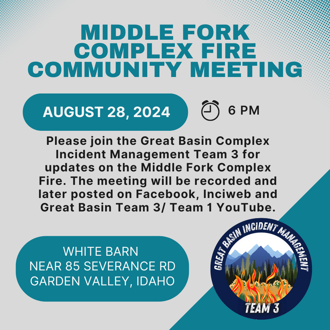
Middle Fork Complex Community Meeting on Wednesday 08 28 2024
Related Incident:
Publication Type: Announcement
Please join the Great Basin Complex Incident Management Team 3 on Wednesday, August 28 at 6 pm at the white barn building near 85 Severance Road, Garden Valley, Idaho for updates on the Middle Fork Complex Fire. The meeting will be recorded and later posted on Facebook, InciWeb and Great Basin Team 3/ Team 1 YouTube.
Ruby Fire Update August 27 2024 08 27 2024
Related Incident: Ruby Fire
Publication Type: News
Ruby Fire Quick Facts
Size: 959 acres Location: North Cascades National Park, Ruby Mountain, Diablo, Washington
Containment: 0% Cause: Lightning/Natural
Start Date: August 9, 2024 Total Personnel: 72
Fire Information:
Inciweb: https://inciweb.wildfire.gov/incident-information/wancp-ruby-fire Email: 2024.Ruby@firenet.gov
Facebook: https://www.facebook.com/people/RubyFire/61563760546137
Phone: 1-360-208-8096
Current Status: Recent steady rains have helped reduce fire spread, heat and smoke. Fire suppression work continues today as safety permits. Access to the fire is difficult due to steep terrain and hazards, with fog and heavy cloud cover often making it difficult for firefighters to assess smoke and fire conditions.
Planned Actions: Firefighters will continue to protect critical infrastructure, park campgrounds, trails, backcountry camps and other resources in preparation for possible fire growth. The Ruby Fire is a full suppression fire, and firefighters are utilizing strategies and tactics that provide the highest likelihood for success, while mitigating risks to firefighters and the public. The main objectives are protecting human life, minimizing damage to values at risk and limiting wildfire spread to the north and west.
Weather: Cloudy and windy with rain showers and thunderstorms on Tuesday. 90% chance for rain, 17% chance for thunderstorms. West winds 13 to 18 mph, gusts to 28 mph. Highs near 66 f. Then cloudy Tuesday evening as rain and thunderstorms end. Northwest winds 8 to 12 mph gusts to 17 mph. Lows near 52 f. A warming, drying weather trend is forecast to start Wednesday.
Closures: There are multiple closures in place for public safety; Colonial Creek South Campground and boat launch, Thunder Arm south of Diablo Lake. For a full list of closures visit https://go.nps.gov/fireclosures
Smoke: Air quality is forecast to be GOOD on Tuesday and Wednesday. https://www.airnow.gov/
Burning Restrictions: Campfires, the ignition of wood, briquettes, or any fuel in fire pits, fire pans and barbeque grills, are banned in all portions of North Cascades National Park Service Complex: North Cascades National Park, Ross Lake National Recreation Area and Lake Chelan National Recreation Area.
Drone Restrictions: Drones can seriously impact the safety of firefighting efforts, and operating drones within North Cascades National Park is prohibited, except with prior written approval from the superintendent.
Cooperating Agencies & Tribes: National Park Service, Upper Skagit Indian Tribe, Seattle City Light, Whatcom County, Whatcom County Sheriff’s Office, Washington State Dept. of Transportation.
If you would like to sign up for our daily updates, please send an email to: 2024.Ruby@firenet.gov