
Limepoint Fire Daily Update August 26 2024 08 27 2024
Related Incident: Limepoint Fire
Publication Type: News
Limepoint Fire – Fire Closure Updated
Monday, August 26, 2024
Contacts for Fire Information: 208-992-3032 or
2024.limepoint@firenet.gov
https://inciweb.wildfire.gov/incident-information/idpaf-limepoint-fire
https://www.facebook.com/payettenationalforest/
The Payette National Forest closure for the Limepoint Fire has been reduced as of 7:00 a.m. today, Monday, August 26, 2024. Landore Road is now open to Black Lake Road on the east side of the fire. Trail 218 is open to the north of the fire. Please follow the link below in the “Closures” section to see the updated fire closure order as well as an updated closure map.
The Limepoint Fire is holding at its current size and percentage of containment. Control lines have been completed in the Boulder Creek area and those firefighters are shifting to new containment lines to the north. The northeastern edge is still being improved with mop up, suppression repair, and hazard tree removal.
Heavy equipment is continuing road grading and suppression repair in the Bear and Huntley Gulch areas. Logging equipment is pulling out trees from when dozers put in a contingency line in Huntley Gulch during the early part of the Limepoint Fire. These will be decked and assessed to determine if they can be salvaged as forest products.
The weather turned warmer Sunday afternoon and that warming trend will continue today. A weak weather system will move north of the fire on Tuesday, but no precipitation is expected. Please observe the fire restrictions (see below) and be careful not cause another fire.
Evacuations: Cuprum remains at a Level 1 (READY) evacuation level and Bear evacuations are lifted completely.
Closures: The Forest Closure Order updated today at 7:00 a.m. Some areas previously closed to the public have been reopened. For details about the closure, visit https://www.fs.usda.gov/alerts/payette/alerts-notices. There is still a lot of work being done in the fire area; for your safety and the safety of firefighters, please observe the existing Payette Forest Closures still in effect and watch out for firefighters and fire traffic.
Restrictions: Stage 1 Fire Restrictions remain in effect for the Payette National Forest and all state, private and BLM lands in the fire area. Under these restrictions, campfires are allowed only in recreation sites within metal fire pits. Fires of any kind are not allowed in any dispersed camping areas.
House Draw Fire Daily Update for August 26 2024 08 26 2024
Related Incident: House Draw Fire
Publication Type: News
Firefighters successfully hold fire perimeters as breezy conditions test containment lines; Community meeting scheduled for August 28 in Birney, MT
Daily Update August 26, 2024
Fire Information Phone: 307-201-3885 (8 a.m. – 8 p.m.)
Media Information Phone: 307-543-7202 (8 a.m. – 8 p.m.)
Email: 2024.housedraw@firenet.gov
Acres: Flat Rock – 52,599; Remington – 196,387; Constitution – 24,594; House Draw – 174,702
Acreage changes may occur due to overnight operations and infrared mapping.
Containment: Flat Rock – 35% Remington – 0%; Constitution – 28%; House Draw – 88%
Location: Flat Rock – 11 miles NW of Gillette, WY; Remington – 20 NE of Leiter WY, multiple counties in SE Montana; Constitution – 15 miles north of Gillette, WY; House Draw – 40 miles southeast of Buffalo, WY
Start Date: August 21, 2024 Personnel: 840 Fuels: Grass, brush and timber
Resources: 24 crews | 3 helicopters | 78 engines | 9 bulldozers | 7 water tenders
Highlights: Crews successfully hold perimeter on Flat Rock, Constitution, Remington and House Draw fires in northeast Wyoming and southeast Montana. A community meeting is scheduled for 6 p.m. on Wednesday, August 28, 2024, at the Birney Post Office (302 Commercial Street, Birney, MT).
Fire Activity: Outflow winds from area thunderstorms tested containment lines across several of the area fires yesterday, Sunday, August 25. Today, firefighters, heavy equipment crews and aerial resources will monitor conditions and respond to on-going fire threats.
Flat Rock – The Flat Rock fire exhibited moderate fire behavior yesterday, as interior unburned pockets of fuel were consumed, primarily within the north flank of the fire where ground and air resources worked in tandem within the pinyon-juniper forests. Today, crews will patrol, monitor and secure fireline, utilizing direct tactics on the north end where active fire is being observed.
Remington – Fire behavior was significantly reduced on the Remington fire yesterday. Today, firefighters will monitor activity on the north end, conducting mopup in the northeast and securing line to the southwest.
Constitution –Today, heavy equipment crews on the Constitution fire will utilize bulldozers to continue constructing containment lines, tying into natural features when feasible. Fire activity on the northern end continues to produce smoke as interior pockets of unburned fuel are consumed.
House Draw – Yesterday, firefighters responded to and successfully extinguished a burning powerline outside the perimeter of the House Draw fire. Today, crews will patrol and mopup remaining heat sources, securing line where needed.
Evacuations: No evacuation orders are in place for Sheridan, Johnson or Campbell Counties, Wyoming. A Level 2 evacuation notice is in effect for Big Horn, Rosebud, and Powder River Counties in Montana.
Weather: The fire area will experience slightly cooler temperatures today with an increased potential for showers and wetting rains.
Fire Restrictions and Closures: Fire Restrictions are in place across the fire area including:
- Stage 1 Fire Restrictions for Custer Gallatin National Forest, Ashland Ranger District. More information available at https://www.fs.usda.gov/alerts/custergallatin/alerts-notices/?aid=89447.
- Stage 1 Fire Restrictions for Bureau of Land Management Buffalo Field Office in Johnson County (as of July 1, 2024) and Campbell and Sheridan Counties (as of July 9, 2024). More information available at https://www.blm.gov/programs/public-safety-and-fire/wyoming/fire.
More Information:
InciWeb (House Draw Fire): https://inciweb.wildfire.gov/incident-information/wyhpd-house-draw-fire
InciWeb (Remington Fire): https://inciweb.wildfire.gov/incident-information/mtgnf-remington-fire
Public Information Linktree: https://linktr.ee/housedrawfire
Facebook: https://www.facebook.com/SWIMT5/
Diamond Complex and Middle Fork Daily Update 08 26 2024
Related Incident: Middle Fork Fire
Publication Type: News
Our primary mission on the Diamond Complex and Middle Fork Fire is to serve the public diligently. With the safety of the public and our firefighters in mind, we are committed to addressing the needs and concerns of your communities by managing and controlling the fires to keep your forests, parks, and natural areas safe and enjoyable. Our firefighters are maintaining mop-up and patrol efforts on contained fires to ensure they remain within the current fire footprint. Utilizing safe, yet effective firefighting suppression methods, our goal is to help you return to enjoying the outdoors.
The Diamond Complex in the Umpqua National Forest consists of 32 lightning-caused fires totaling approximately 11,152 acres and is 68% contained. Twenty-eight of the 32 fires in the Diamond Complex are now 100 percent contained. The Twin fire is 0.1 acres and has fireline around it.
The Middle Fork Fire in the northwest corner of Crater Lake National Park is 5,280 acres and is 2% contained. The fire is primarily burning within the 2015 National Creek and 2017 Spruce Lake fire scars. Throughout the fire area there is an extreme hazard to firefighters due to falling dead standing trees remaining from the 2015 and 2017 fires.
Yesterday, the firelines were tested by the decrease of relative humidity and dryer conditions, leading to the 4% increase in containment on the Diamond Complex. Today, crews will focus on continuing mop up, looking for remaining heat identified by infrared monitoring. They will also continue with suppression repair, which involves restoring areas affected by firefighting efforts. Additionally, an initial attack group including hand crews, engines, dozers, water tenders, falling modules, and task force leaders are ready to respond swiftly to any new fire starts.
OPERATIONS:
Middle Fork Fire: (5,280 acres, 2% contained):
Crews continue to remove heavy timber and vegetation to create a shaded fuel break along the 230 Road and at the north entrance to Crater Lake National Park. The north entrance to Crater Lake National Park remains closed. Infrared monitoring has detected limited spread of the fire. Hotshot crews will camp out for the next few days to address the areas of heat identified by the infrared scans. The park remains open.
Diamond Complex Fires:
Pine Bench Fire (North of Hwy 138 near Dry Creek, 3,990 acres, 52% contained):
Infrared sensing along the northern edge of the fire is showing few hot spots and reduced fire activity in the Wilderness. Firefighters are working hotspots and taking advantage of aviation resources to assist with the hazards for firefighters in steep terrain.
Potter Fire (North of Hwy 138, two miles southeast of Potter Mountain, 3,416 acres, 15% contained):
Crews are continuing to mop up from the North towards Nancy Creek. Hotshot crews will be working on the south and east side as directly on the fire’s edge as possible. Firefighters are continuing to secure and mop up while maintaining safe and effective operations in steep and difficult terrain.
Ooya Fire (North of Hwy 138, one mile northeast of Bird Point, 374 acres, 100% contained): Crews are beginning to repair all areas impacted by suppression efforts with the help of identified resource experts.
Other fires within the Diamond Complex:
Loafer Fire (44 acres, 56% contained)
Twin Fire (0.1 acres, 0% contained)
Fish Fire (.5 acres, 0% contained)
Crews have plans to create a fireline around and mop up.
WEATHER AND FIRE BEHAVIOR:
High pressure will build over the fire area today, which will allow temperature and humidity values to trend back to seasonal normal. This will lead to elevating fire weather conditions as relative humidity values become dry and winds increase out of the west. It will be mostly sunny with just some high clouds streaming across the area. A weak cold front will push through the region on Tuesday bringing high clouds and an upward trend in westerly winds. Much drier air will arrive in the area by Wednesday.
SMOKE OUTLOOK:
For the most up to date information, please visit fire.airnow.gov/
EVACUATIONS:
None. As of August 23, 2024, the Douglas County Sheriff’s Office has lifted evacuation orders for all areas.
FOREST CLOSURE:
On August 21, 2024 the Forest reduced the temporary closure order, allowing increased access to specific roads, trails, and campgrounds that are listed as exemptions in Forest Order 06-15-24-06. For more information visit the Umpqua National Forest website at: https://www.fs.usda.gov/alerts/umpqua/alerts-notices/?aid=88996
The Rogue River-Siskiyou National Forest has issued a closure for the area north and west of Crater Lake National Forest along Highway 230 south to the intersection with Highway 62. See the Closure Order and map at https://www.fs.usda.gov/alerts/rogue-siskiyou/alerts-notices.
PARK CLOSURE:
The North Entrance Road is closed from North Junction to the park boundary at the junction with Highway 138. This closure is necessary to ensure the safety of fire crews and the public. The date for reopening is not known at this time. All other park roads will remain open, except for construction closures on East Rim Drive. Crater Lake National Park remains open and is accessible from Highway 62 on the western and southern routes.
Crater Lake National Park has several closures in effect, closure orders and maps can be found at:
https://www.nps.gov/crla/learn/news/temporary-closure-of-north-entrance-road-continues.htm
REMINDER: The Pacific Crest Trail between the Lightning Springs and Rim Trail Intersections, Bald Crater Loop, Bert Creek and Boundary Springs Trails are closed until further notice due to potentially hazardous conditions created by the Middle Fork Fire. Hikers and bikers may not use the North Entrance Road to enter or leave Crater Lake National Park.
Boise Fire Update August 26 2024 08 26 2024
Related Incident: 2024 Boise Fire
Publication Type: News
Headlines:
• Traffic control remains in place along the Salmon River Road between Butler Flat and Nordheimer Flat for the safety of firefighters and residents. Expect up to 30-minute delays. Incident personnel driving vehicles with more than two axels will not be allowed on the road.
• Fire information phone: (707) 572-4860 or email at 2024.Boise@firenet.gov
• Get all your Boise Fire information in one mobile-friendly place! https://linktr.ee/2024boisefiresrf
• Evacuations are in place for residents near the fire area in Humboldt County. For the most current evacuation information please visit the Boise Fire linktree or visit--
✓ Humboldt County: https://humboldtgov.org/356/Office-of-Emergency-Services
✓ Siskiyou County: https://www.co.siskiyou.ca.us/emergencyservices
Leader’s Intent: The Boise Fire is being managed with a full suppression strategy.
Operational Update: On the west side of the fire, firefighters continue to mop up, patrol, and chip vegetation along the roadways. Some damaged roads have been repaired to allow crews to access the fire’s edge. Two new spike camps have been created along the east side of the fire to decrease the travel time for crews. Additionally, new heli-spots have been created to facilitate the movement of equipment and personnel. Multiple crews are being inserted into the China Creek area to create handline along the fire’s edge.
Weather and Fire Behavior: Drier and warmer weather is expected to return to the area. With the recent moisture, no significant fire movement is expected. As conditions continue to dry, fire activity may pick up.
North Willamette Complex Ore and Pyramid Fires Daily Update 08 26 2024
Related Incident: North Willamette Complex
Publication Type: News
Willamette Complex North
Daily Update
2024.WillametteComplex.North@firenet.gov
Information line: 541-208-1262, 8 am to 8 pm
Facebook: https://www.facebook.com/OreFireInformation2024/
https://www.facebook.com/PyramidFireInfo2024/
Inciweb: Willamette Complex North
August 26, 2024
SUPPRESSION OBJECTIVES: The Ore Fire and the Pyramid Fire remain under a full suppression strategy to protect values at risk, including the Middle Santiam Wilderness and private timberlands. Firefighters are using a combination of direct fire line where conditions permit, and indirect fire line where it is necessary to work at a distance from the fire’s edge.
CURRENT SITUATION: A slow warming/drying trend will lead to gusty conditions mid-week and above average temperatures and low humidities by week’s end. Firefighters are making access where safely possible, continuing containment line improvements and contingency work. Pockets of heat from dense fuels remain within the fire interior and increased fire behavior will be possible as skies clear, temperatures rise, humidities drop, and fuels begin to dry.
Ore Fire: 7 miles Northeast of Blue River, 3,147 acres, 25% contained, 659 total personnel, human caused. Overnight, crews continued to patrol and secure containment lines. Today crews are scouting locations for direct hand line construction, mop up, and securing containment lines where possible. Contingency resources will work on fuel break improvements, chipping, masticating, and improving handline construction. Mastication is the process by which machinery is used to cut, chop, and grind vegetation into smaller pieces. A contingency line is a secondary or alternate strategic fire line, which is created as a back up to the primary fire line, based on current needs and conditions. Unmanned Aerial System flights with infrared detection capabilities confirmed that fires have not crossed any containment lines.
Pyramid Fire: East of Middle Santiam Wilderness, 1,312 Acres, 98% contained, 221 total personnel, lightning caused. Recent moisture has helped heavy equipment operators working on grading and improving roads. Roadside fuel hauling and brush chipping is ongoing, and crews continue to secure containment lines and fortify outlying contingency lines. Firefighters continue to strengthen existing fire breaks along roads by removing brush and smaller trees.
CLOSURES & FIRE RESTRICTIONS UPDATE: Please refer to the Linn County Fire Map for current status.
Numerous area, road, trail, and recreation site closures are in effect on the Willamette National Forest. Specific information is posted at https://www.fs.usda.gov/alerts/willamette/alerts-notices/?aid=61574. Please see Pyramid Fire Area Closure Forest Order and the Ore Fire Area Closure Forest Order.
Everyone is reminded to stay out of all fire closures for firefighter and public safety. Violations of these prohibitions are punishable by a fine of up to $5,000.
Due to long term hot and dry conditions, all campfires, charcoal fires, pellet fires, or any other open fires are prohibited, including in developed campgrounds and wilderness areas. Pressurized liquid or gas stoves, lanterns, and heaters that can be switched on and off are allowed. Please see Forest Order 06-18-00-24-27 for additional information.
ROADS: When traveling in the area, please be mindful of firefighters and their vehicles working near roads. Please visit the Oregon Department of Transportation website for current road conditions.
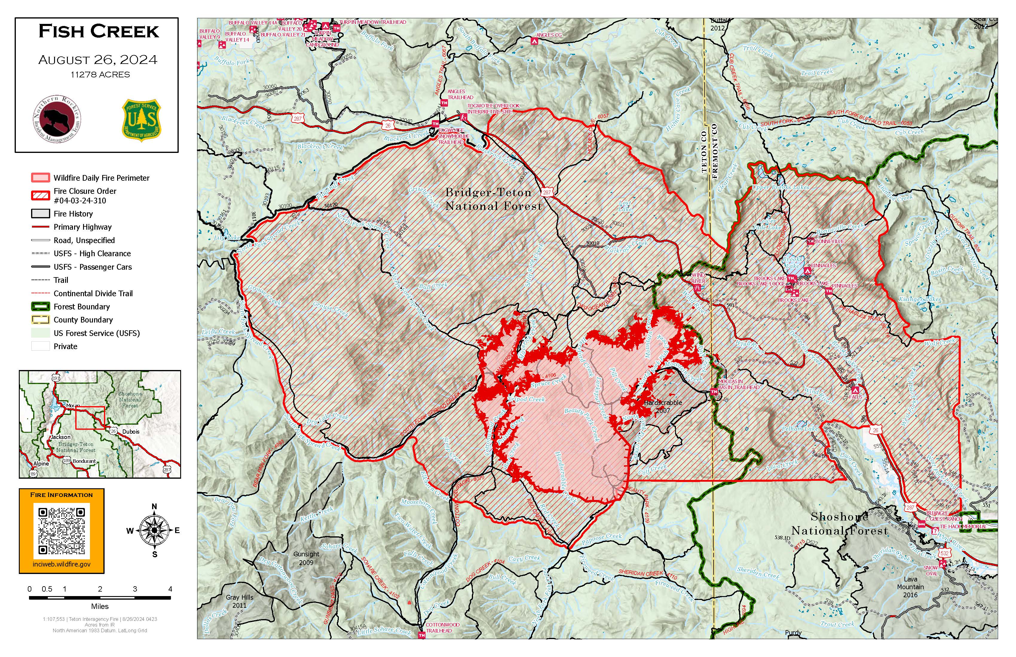
Fish Creek Fire Update Monday 08 26 2024
Related Incident:
Publication Type: News
Northern Rockies Team 1, Incident Commander Brent Olson
Location: 7 miles SW of Togwotee Pass
Start Date: Friday, August 16, 2024
Cause: Lightning
Size: 11,278 acres
Percent complete: 23%
Resources: 331 Total Personnel; 1 Masticator; 1 Feller Buncher; 5 Helicopters; 8 Hand Crews; 13 Engines
KEY MESSAGE:
A Fish Creek Fire Community Meeting is planned for today from 6 to 7pm in the Poolaw Building at the National Museum of Military Vehicles just east of Dubois, Wyoming. Fire managers and local officials will provide an overview of the status of the fire, fire suppression efforts, and the closure area.
Current Status:
Cooler weather conditions yesterday allowed firefighters the opportunity to scout indirect fire line locations in locations primarily northwest, north, and northeast of the active fire area relative to the values identified to be at risk from fire activity. Indirect fire line construction was improved from Highway 26 to Pilot Knob with additional indirect line construction continuing south toward the Moccasin Basin Trailhead. Firefighting resources utilized heavy equipment to reduce vegetation along Deception Road to prepare it as an indirect control line. On the southwest corner firefighters conducted a small firing operation near Red Creek to secure the uneven fire edge. Structure protection crews continued to install pumps, hose, and sprinklers in the Brooks, Pinnacle and Breccia areas. Additional firefighting crews and equipment have been ordered and are arriving to support work on the fire.
Today, the scouting and planning of indirect fire line will continue relative to protecting the values at risk. Some of the areas where crews will be working include the Holmes Cave Trail and Spread Creek tying into the Flagstaff Road. A lot of the indirect line work is focusing on the areas north of Highway 26 and northwest of the fire based on the forecast of warmer and drier conditions later this week. Structure protection crews plan to complete prep work in Brooks, Pinnacle and Breccia and then shift to additional locations to begin more structure assessments.
This incident is being managed under a confine/point protection strategy. Confine is a wildfire response strategy of restricting a wildfire to a defined area, primarily using natural barriers that are expected to restrict the spread of the wildfire under the prevailing and forecasted weather conditions. Point protection may include the installation of pumps, sprinkler systems, vegetative fuels reduction, and other measures to protect identified values-at-risk. The “percent complete” figure associated with the incident refer to the degree to which these actions have been accomplished.
Weather and Fire Behavior:
Today will be cooler and wetter on the end of a weather system departing the area. Expect showers and thunderstorms to decrease through the rest of the morning. Winds will be lighter out of the west with gusts mostly remaining below 20 mph. Given the moisture, humidity will remain above 45 percent through the afternoon. Conditions become warmer and drier on Tuesday.
The wetting rain overnight and continuing into today will reduce fire activity for today’s shift. Sage/grass, meadow systems, and the 2007 Hardscrabble Fire footprint will serve as a barrier to spread today. Pockets of dead and down timber will continue to burn with smoldering and creeping fire behavior. Primarily low flame lengths and rates of spread are likely today in timber.
AIR QUALITY AND SMOKE:
Air quality and smoke conditions and forecasts can be found at https://www.airnow.gov/.
Closures and Evacuations:
A joint Closure Order for the fire area has been issued by the Bridger-Teton and Shoshone National Forests for public and firefighter safety. Please do not enter the closure area or use the Forest Roads that are closed.
The Fish Creek Area, Roads, and Trails Closure Order (map) has been established for public and firefighter safety in the fire area. Full details can also be found at https://www.fs.usda.gov/alerts/btnf/alerts-notices.
Fremont County: Brooks Lake, Pinnacle Drive and Breccia Drive area remain in the Level 2 Evacuation notice. A Level 2 Evacuation means “Be Set” to evacuate. You must prepare to leave at a moment’s notice. This level indicates there is significant danger to your area, and residents should either voluntarily relocate to a shelter or with family/friends outside of the affected area, or if choosing to remain, to be ready to evacuate at a moment's notice. See the alert notice on the Fremont County Fire Protection District Facebook page.
Teton County: The Teton County Division of Emergency Management utilizes a Ready, Set, Go www.tetoncountywy.gov/1846/Ready-Set-GO system for evacuation messaging. All residents should be in the Ready status by preparing for evacuations and becoming fire adapted.
US HWY 26/287 continues to experience smoke and sometimes limited visibility. Wyoming Department of Transportation (WYDOT) is working closely with Fremont County Emergency Management and fire officials for the safety of motorists and firefighters. Drivers are encouraged to visit https://www.wyoroad.info/ prior to traveling on US HWY 26/287 for road status and information, or download the Wyoming 511 app at https://www.wyoroad.info/511/WY511Mobile.html to monitor for any changes due to fire activity.
Middle Fork Complex Fire Update for Monday 08 26 2024
Related Incident:
Publication Type: News
Middle Fork Complex Update
Monday, August 26, 2024
Fire Size: 46,994
Completion: 5%
Resources: 6 helicopters, 32 engines, 13 hand crews
Total Resources: 659
Community Meeting: A community meeting will be held today at 6:00 p.m. at the white barn building, located at 85 Severance Road, Garden Valley, ID. The Incident Commander, key team members, and representatives from the Boise National Forest will provide updates on the Middle Fork Complex Fire and address any questions.
Weather and Fire Behavior: For today, temperatures will continue to trend upward with decreasing humidities. Skies will be mostly clear as a drier weather system approaches the area on Tuesday. This will result in a return of increased fire behavior and potential for spot fires to become more active.
Operations: The weather today continues to allow for improved firefighting conditions, allowing crews to prepare new containment and contingency lines and undertake various suppression tactics.
Efforts continue along FS Road 698 and onto FS Road 671 to contain the Bulldog Fire, focusing on the western edge. Structure protection improved greatly today, and crews will continue to patrol the area. Crews established indirect line along the northern and northeastern edge of the fire, tying in the containment line with existing firebreaks.
The new indirect lines constructed on the western edge on the Nellie fire were further supported by aerial retardant drops today. The Highway 17 corridor saw tactical firing operations today to further protect infrastructure. Highway 17 will also have night crews in place to further support operations there.
Crews and aerial resources were engaged in suppressing spot fires on the northwestern side of Deadwood Reservoir. Additionally, crews have been “spiked out,” or setting up a secondary small, supported fire camp close to the fire line. The goal is to herd the Nellie Fire to a previously burned area and from keep it from moving farther north. This tactic allows crews to shorten travel time and spend more of the working period fighting the fire. No homes or infrastructure in the Deadwood reservoir area have been lost.
Closures: The Boise National Forest has issued Order Number 0402-06-59, effective August 23, 2024. For additional details, please visit the Boise National Forest website at https://www.fs.usda.gov/alerts/boise/alerts-notices. Hwy 21 is closed from the Sourdough Lodge in Lowman to Stanley (MP 84 to 130) due to wildfire activity. Only local traffic is permitted between the Sourdough and Warm Springs Airstrip. Visit https://511.idaho.gov/ for more road info.
Temporary Flight Restrictions (TFR): A TFR is issued over the fire area. It is illegal for members of the public to fly drones over or near wildfires because of the potential for accidents and disruption of suppression operations.
Flat Fire Update August 26 2024 08 26 2024
Related Incident:
Publication Type: News
August 26, 2024
Email: 2024.flat@firenet.gov
Incident Information Phone Line: 208-923-1265 - daily 8 a.m. to 8 p.m.
Flat Fire Facebook: https://www.facebook.com/IdahoDepartmentofLands
InciWeb: https://inciweb.wildfire.gov/incident-information/idids-2024-flat
Smoke Report: https://www.airnow.gov
Flat Fire Facts
Location: Approximately one mile northeast of Pioneerville in Boise County, Idaho
Reported: August 5, 2024; Cause: Lightning/Natural
Acres: 3,734; Containment: 61%
Fuels: Timber with grass and understory
Personnel: 301 (6 hand crews, 5 engines, 5 water tenders, 1 dozer, 3 masticators and 1 helicopter)
Highlights: Yesterday, both acreage and containment remained unchanged. Fire managers feel confident with the containment lines along the southern, western, and northern sides of the fire, and saw very little fire behavior where the Flat Fire has burned into the 2016 Pioneer Fire Burn Scar. This eastern edge of the fire will continue to be closely monitored to prevent any impacts to the Idaho City watershed.
Tomorrow, crews will continue chipping debris alongside the Summit Flat Road (#380), graders will be working on the Elk Creek Road (FS RD 379), and excavators will continue suppression repair installing water bars on dozer lines. Due to the decrease in fire activity and complexity, the Flat Fire will be transitioned to an Idaho Department of Lands Type 4 organization on Tuesday at 6:00 a.m. The incoming team will spend today working with Great Basin Team 6 to successfully transition. The Type 4 organization will continue to patrol, monitor, and perform suppression repair to ensure the fire stays in its current footprint.
This will be the final update from Great Basin Team 6. We thank you for your support and welcoming us into your communities.
Fire Behavior and Weather: In the coming week, temperatures will rise topping out in the middle to upper 80s and approaching 90 degrees by Labor Day Weekend. Relative Humidity values will continue to lower returning to critical thresholds by the middle of the week, lasting through the holiday weekend. Periods of elevated fire weather conditions can be expected.
Road and Trail Closures and Restrictions: Currently, much of the state of Idaho is under Stage 1 Fire Restrictions including lands within the boundary of the Boise National Forest. Please do your part and learn more about current Fire Restrictions in the state at: https://www.idl.idaho.gov/fire-management/fire-restrictions-finder/.
The Boise National Forest has implemented an Area Closure for the Flat Fire. See link for additional information: https://www.fs.usda.gov/alerts/boise/alerts-notices. The Summit Flat Road (#380) between Pioneerville and Coulter Summit and FS Road 379 (Elk Creek Road) is closed for public and firefighter safety.
Fires Burning in the Vicinity: There are other fires burning north of the Flat Fire. See link for additional information: https://inciweb.wildfire.gov/incident-information/idbof-middle-fork-complex-fire-bulldog-nellie-anderson.
###
West Mountain Complex Daily Update 08 26 2024
Related Incident: Wolf Creek FireDollar Fire Boulder Fire
Publication Type: News
WEST MOUNTAIN COMPLEX
Boulder, Snag, Wolf Creek, Dollar & Goat Fire Updates
August 26, 2024
Fire Location Size Containment Start Date
Boulder 9 miles SW of Cascade 2,313 acres 44% 7/24/2024
Wolf Creek 5 miles W of Donnelly 1,154 acres 95% 7/24/2024
Snag 11 miles E of Cascade 25,235 acres 3% 8/5/2024
Dollar 18 miles NE of Cascade 2,665 acres 0% 8/5/2024
Goat 11 miles SE of Cascade 1,963 acres 0% 8/5/2024
Cause: Lightning (All Fires)
Total Incident Personnel: 1,094
Army crews from the 14th Brigade Engineer Battalion based at Joint Base Lewis McChord are currently assisting with suppression efforts on the West Mountain Complex.
Weather | Anticipated Fire Behavior:
Yesterday’s conditions produced low fire behavior, including creeping, smouldering, and isolated torching due to higher humidities, calmer winds, and morning cloud cover. Today, warmer and drier conditions will allow firefighters to conduct necessary burnout operations to help improve and secure containment lines. If weather conditions permit, planned burnout operations will produce additional smoke in the regions of the Snag Fire and Boulder Fire.
Boulder Fire:
Yesterday on the south side of the Boulder Fire, firefighters continued mopping up and securing handline. An infrared flight showed areas of scattered heat on the southwest side, and crews will work today to extinguish them. Army crews assisted with the mop up using hose lays. Crews also used chippers to reduce buildup of vegetation on the unburned side of the control lines to mitigate any future possibility of new spot fires. Areas of heat discovered along the northwest side of the fire yesterday temporarily suspended further chipping. Crews will work to suppress those hot spots today. Burnout operations may occur along the northeast corner where vegetation within containment lines remains unburned.
Dollar Fire:
There was minimal activity yesterday on the Dollar Fire. Crews continued to assess and improve the handlines leading up to the Needles ridge to prepare for a burnout operation on the western edge of the fire perimeter. The burnout operation will safely remove any remaining green pockets between the handline and the area that has already burned. If weather and safety parameters are met, that burnout operation could take place today.
Snag Fire:
There was a little more fire activity yesterday on both the southwest and northern ends of the Snag Fire. Army crews assisted firefighters to improve indirect fire line while patrolling and mopping up hot spots. If safety parameters and weather conditions permit, crews hope to perform burnout operations today to consume islands of unburned vegetation to secure containment lines. These operations would occur in the area north of the Warm Lake Highway, on the western edge, and on the southwestern most edge of the fire.
Wolf Creek Fire:
Crews continued to monitor the Wolf Creek Fire today, which is still 95% contained. Firefighters mopped up hot spots within the interior of the perimeter yesterday. They are continuing suppression repair and rehabilitation, actions which are expected to continue over the next two weeks.
Goat Fire:
Flights over the Goat Fire and assessments on the ground are providing the fire planning team with information and insight on potential natural control features if the Goat Fire were to spread to the south. There was some active fire in the bottom of Goat Creek yesterday. The planning team is assessing future actions to maintain contingencies should there be any significant wind shifts in future days. The unmanned aerial system (UAS) will be used for recon missions today.
Frequently Asked Question Q: On the West Mountain Complex, a combination of confine and contain, and full suppression strategies are being applied. What is the difference between full suppression and a confine and contain strategy?
A: Under a full suppression strategy, firefighters and or equipment is used to construct containment lines to prevent the fire’s forward progress. Under a confine and contain strategy, incident managers identify existing features on the landscape, such as roads, trails, rocky ridges, and previously burned areas that will naturally halt the fire due to a change in fuels conditions. ”Confine and contain” is most often applied when a fire is located in steep or inaccessible terrain, or poses immediate danger to firefighters due to overhead hazards or other hazardous conditions.
Other regional fire information:
Middle Fork Complex (Nellie, Anderson, and Bulldog Fire): https://tinyurl.com/3rhawr5y
Wapiti Fire: https://tinyurl.com/yf7reydj
Bulltrout Fire: https://tinyurl.com/tatwwk5t
SNAG FIRE EVACUATION INFORMATION
The Valley County Sheriff’s Office issued a “ready” evacuation order for Warm Lake residents and the North Shore Lodge at Warm Lake on August 7. The map can be found on Inciweb: https://tinyurl.com/42auxnk8. A second “ready” evacuation order was issued on August 8 for the Horsethief area, including the YMCA Camp, and areas of Scott Valley. This map can also be found on Inciweb, with the relevant areas outlined in purple: https://tinyurl.com/4vfj657x
Review the READY, SET, GO evacuation procedure for Valley County: https://www.co.valley.id.us/ReadySetGo
For timely information on evacuations, check out your county’s emergency alert system.
- Valley County: https://www.co.valley.id.us/CompleteEmergencyNotificationandAlerting
- Adams County: https://public.alertsense.com/SignUp/PublicUser.aspx?regionid=1077
ROAD CLOSURES
Warm Lake Highway Closure: The Valley County Sheriff’s Office is planning to allow residents and vetted contractors (those providing services to residents in the Warm Lake, Yellow Pine, and Big Creek areas) to come and go as needed without an escort along the Warm Lake Highway, dependent on weather and fire activity. The highway remains closed to the public and will only be open to those approved in advance by the Sheriff’s Office. For updates on county closures visit: https://www.co.valley.id.us/departments/SheriffsOffice.
FOREST CLOSURES
Hunting Closures: Prior to entering the backcountry, Idaho Fish and Game advises hunters to check with their local Forest Service ranger district offices or county sheriffs’ offices for fire closures in their hunt areas. For more information visit: https://tinyurl.com/4td8hwzc
The Boise National Forest modified or expanded their wildfire closures on August 12, 2024, to address public and firefighter safety and respond to increased wildfire growth. This closure area begins at the south end of the Dollar/Oro (Snag) fire closure area and continues south to Crouch and the Banks-Lowman Hwy, and east to the 579, 563 and 582 roads.
Dollar Fire Closure:
The Payette National Forest implemented an area closure on August 23, covering an area north of the Boise National Forest closure, to provide for public safety around the Dollar Fire. National Forest System trails #099, #100, #101, and #302 are impacted by the closure.
Wolf Creek Fire Closures: On the Payette National Forest, a closure includes popular National Forest System roads around the Wolf Creek fire such as: sections of NFS Road #1763 (West Mountain Jeep Trail), #835, #206, and #326. On the Boise National Forest, Forest Road #435 (Anderson Lake Road) was closed on August 1.
Boulder Fire Closures: The Boise National Forest has issued a closure order #0402-04-98 for National Forest System (NFS) roads, trails and lands encompassing the Boulder Fire. The closure was enacted to protect public safety and support fire suppression activities. The closure includes Blue Lake and Snowbank Mountain Road (#446) along with all #404 and #421 system roads.
For maps and more detailed descriptions of the closures on the Payette National Forest, please visit: https://www.fs.usda.gov/alerts/payette/alerts-notices
For maps and more detailed descriptions of the closures on the Boise National Forest, please visit: https://www.fs.usda.gov/alerts/boise/alerts-notices
Fire Restrictions: Stage 1 Fire Restrictions have been issued for the Payette Fire Restrictions Area on the Payette National Forest and the West Central Mountains Fire Restrictions Area on the Boise National Forest. For more information on the restrictions and a very helpful interactive map, visit https://www.idl.idaho.gov/fire-management/fire-restrictions-finder/
Temporary Flight Restrictions
Temporary Flight Restrictions (TFR) are in place over the Boulder, Dollar, Snag, and Goat Fires. Wildfires are a no-fly zone for unauthorized aircraft, including drones. If you fly, we can’t. For more information, visit http://knowbeforeyoufly.org.
Important Links
- Payette National Forest: https://www.fs.usda.gov/payette
- Payette National Forest Facebook: https://www.facebook.com/PayetteNationalForest
- Boise National Forest: https://www.fs.usda.gov/boise
- Boise National Forest Facebook: https://www.facebook.com/BoiseNationalForest
- Idaho Department of Lands: https://www.idl.idaho.gov/fire-management/
Forest Service BAER Team Begins PostFire Assessment of Park Fire 08 24 2024
Related Incident: Park Post-Fire BAER
Publication Type: News
Forest Service BAER Team Begins Post-Fire Assessment of Park Fire
A Forest Service Burned Area Emergency Response (BAER) team has been established by the Lassen National Forest to begin a post-fire burned area assessment of the Park Fire that recently burned on National Forest, state, and private lands. The BAER team leaders are Kendal Young, Brenna Montagne, and Anna Plumb. Forest Service BAER team assessments typically take approximately two weeks to complete.
BAER teams coordinate with the Natural Resources Conservation Service (NRCS), National Weather Service (NWS), US Geological Survey (USGS), Bureau of Land Management (BLM), and other federal, state, counties, and other local agencies as they assess potential post-fire impacts to the burned watersheds. For the Park Fire, the Lassen NF also coordinated with Tehama, and Butte Counties, including the following tribes: Pit River Tribe, Redding Rancheria, Mechoopda Tribe and Paskenta Band of Nomlaki Indians.
Emergency Stabilization-Burned Area Emergency Response (BAER) surveys are rapid assessments to identify imminent post-wildfire threats to human life and safety, property, and critical natural or cultural resources on National Forest System lands. The BAER team evaluates the burned area to identify watersheds having increased potential for post-fire flooding, sediment flows and rockslides, and assist land managers to prepare for seasonal thunder cell storms or winter rainstorms. They also model hydrologic response throughout the burned area and share the team’s findings with the affected downstream agencies.
BAER teams may consist of scientists and specialists including hydrologists, geologists, soil scientists, road engineers, botanists, biologists, archeologists, and geographic information specialists. BAER teams collect field data during their burned area surveys to analyze through GIS and computer models and present their findings along with recommended BAER emergency stabilization treatments in a BAER assessment report.
The development of the soil burn severity map for the Park Fire was an interagency collaboration between the California State Watershed Emergency Response Team (WERT), and the Forest Service BAER team. The teams utilize satellite imagery and specialist data to analyze fire effects, produce erosion potential and debris-flow maps, and model post-fire flows. This is the first step in assessing potential watershed impacts from wildfires to any federal values that may be at-risk from potential increased flooding, sedimentation, debris flows, and rockslides. BAER teams produce a report that describes potential threats associated with the burned area’s post-fire conditions and sometimes include recommended emergency stabilization measures and actions. BAER emergency response efforts are focused on the protection of human life, safety, and property, as well as critical cultural and natural resource values such as the water quality of streams and wetlands on federal lands.
BAER reports are shared with interagency cooperators such as California Office of Emergency Services (CalOES), NRCS, California-WERT, and the affected counties who work with downstream private home and landowners to prepare for potential post-fire flooding and debris flow impacts. California-WERT and Forest Service BAER teams coordinate with each other during the assessment of the burned area to ensure post-fire threats are identified.
Homes or businesses that could be impacted by flooding from federal land that result from wildfires may be eligible for flood insurance coverage from the National Flood Insurance Program (NFIP). Information about NFIP is available through FEMA at www.fema.gov/national-flood-insurance-program, or www.floodsmart.gov/wildfires. Other flood preparedness information is available at www.ready.gov/floods at www.floodsmart.gov/.
Additional information on understanding the BAER program, process and other post-fire information is posted on the Park Post-Fire BAER InciWeb page found at: Calnf Park Postfire Baer Information | InciWeb (wildfire.gov).
BAER SAFETY MESSAGE: Everyone near and downstream from the burned areas should remain alert and stay updated on weather conditions that may result in heavy rains and increased water runoff. Flash flooding may occur quickly during heavy rain events--be prepared to act. Current weather and emergency notifications can be found at the National Weather Service website: www.weather.gov/sto/.
###