
Middle Fork Complex Fire Update for Tuesday 08 27 2024
Related Incident:
Publication Type: News
Middle Fork Complex Update
Tuesday, August 27, 2024
Fire Size: 47,400
Completion: 5%
Resources: 6 helicopters, 32 engines, 13 hand crews
Total Resources: 724
A community meeting will be held tomorrow, Wednesday, at 6 p.m. at the White Barn Building, 85 Severance Road, Garden Valley, Idaho. Updates will be provided by the Incident Commander, key team members, and Boise National Forest representatives.
Weather and Fire Behavior
Today, stronger winds blowing from the west-southwest are expected, and a dry cold front will move through the fire area, bringing low humidity. This may increase fire activity, which could lead to faster spread, torching, and spotting. Moderate growth is anticipated. The wind will shift and blow from the west-northwest tonight, and skies will clear. Temperatures are expected to decrease on Wednesday but are projected to rise again later in the week.
Operations
Recent progress has put crews in a good position before the upcoming weather. For the Bulldog Fire, containment lines remain secure along FS Roads 698 & 671.
Crews will assess options for indirect containment line to the north of the Bulldog area to tie into trails and previously burned areas. Structure protection crews will continue to patrol Crouch and Garden Valley.
Heavy equipment crews built containment lines along the southwestern edge of the Nellie fire connecting to Highway 17 on the southern end. Air tankers used retardant to further strengthen these lines. To the north of the highway, successful tactical firing operations expanded on previous work. Night shift crews will patrol and monitor the Banks Lowman Highway.
Crews and aerial resources were engaged in suppressing spot fires on the eastern side of Deadwood Reservoir. The goal remains to herd the Nellie Fire to a previously burned area and from keep it from moving farther north. No homes or infrastructure in the Deadwood reservoir area have been lost.
Closures
The Boise National Forest has issued Order Number 0402-06-59, effective August 23, 2024. For more details, please visit the Boise National Forest website at https://www.fs.usda.gov/alerts/boise/alerts-notices. Highway 21 is closed from the Sourdough Lodge in Lowman to Stanley (MP 84 to 130) due to wildfire activity. Only local traffic is permitted between the Sourdough Lodge and Warm Springs Airstrip. For additional information, visit https://511.idaho.gov/
Temporary Flight Restrictions (TFR)
A TFR is in effect over the fire area. It is illegal for the public to fly drones over or near wildfires due to the risk of accidents and interference with firefighting eff
West Mountain Complex Daily Update 08 27 2024
Related Incident: Wolf Creek FireBoulder FireDollar Fire
Publication Type: News
WEST MOUNTAIN COMPLEX
Boulder, Snag, Wolf Creek, Dollar & Goat Fire Updates
August 27, 2024
QUICK FACTS
Fire Location Size Containment Start Date
Boulder 7 miles SW of Cascade 2,396 acres 57% 7/24/2024
Wolf Creek 8 miles SW of Donnelly 1,154 acres 95% 7/24/2024
Snag 8 miles E of Cascade 27,398 acres 3% 8/5/2024
Dollar 17 miles NE of Cascade 2,930 acres 0% 8/5/2024
Goat 11 miles SE of Cascade 2,253 acres 0% 8/5/2024
Cause: Lightning (All Fires)
Total Incident Personnel: 1,084
Army crews from the 14th Brigade Engineer Battalion based at Joint Base Lewis McChord are currently assisting with suppression efforts on the West Mountain Complex.
Weather | Anticipated Fire Behavior:
Yesterday’s warmer and drier conditions allowed for firing operations on the Snag Fire north of Warm Lake Road and along the southwest corner. Continued warm and dry conditions today will allow for additional firing operations to aid in securing lines. Under these warming and drying conditions, increased fire behavior is expected.
Boulder Fire: https://tinyurl.com/ycdfv3tv
An infrared flight on Sunday night showed areas of scattered heat on the southwest side of the Boulder Fire. Yesterday, firefighters and army crews used hose lays to mop up hotspots, reducing the chance for fire spread. Mop up and chipper operations along the western flank will continue, reducing buildup of vegetation and mitigating potential for new spot fires.
Dollar Fire: https://tinyurl.com/bef6r3tz
Yesterday, increased fire activity on the northern edge spread into the Payette National Forest. Crews prepared line in this area for an expected firing operation today. Army crews will provide support for the firing operation. Firing operations aid in containment by safely removing remaining pockets of fuel between the handline and the existing burned area. Increased fire activity is expected today, and a helitack crew is assigned to assist with reconnaissance and monitoring of fire activity.
Snag Fire: https://tinyurl.com/4k9dk3mu
The Snag Fire crews conducted firing operations yesterday and will continue today. In addition to firing operations north of Warm Lake Highway, firefighters and Army crews mopped up and secured along the western flank yesterday. On the fire’s interior, crews removed heat that was threatening an unburned cabin. Today, crews will mop up and patrol areas burned yesterday along Warm Lake Road and continue mopping up and securing line along the western flank. Additional firing operations are planned along the southern end of the fire, east of Forest Road 406 and north of Forest Road 409. Army crews will support by holding the fire line during these operations.
Wolf Creek Fire: https://tinyurl.com/mcksrfvh
At 95% containment, the focus on the Wolf Creek Fire is mopping up any remaining hotspots, repairing and rehabilitating fire line, and backhauling equipment so it can be used on other fires. These actions will continue over the next few weeks. Management of the fire returns to the Payette National Forest at 6 am Wednesday, Aug. 28.
Goat Fire: https://tinyurl.com/2h4a3dvr
A contingency line was prepared along the East Trail yesterday, in case the fire should advance to the northwest, while air reconnaissance continued over the fire area. A Wildland Fire Module will conduct ground reconnaissance and take fuel samples to aid in the development of plans and strategies for establishing containment.
Frequently Asked Question
Q: Why are forest closures in place?
A: Public and firefighter safety is the top priority on every incident. Closures protect the public from hazards, such as burning stump holes, heavy equipment use, fire weakened trees that can fall long after a fire front passes, and other concerns. Roads are often used as containment lines, so firefighters are frequently found working directly on roadways where visibility may be obscured by heavy smoke. Therefore, closures reduce traffic and promote firefighter safety. They allow firefighters to focus on their work with less concern for public safety.
Other regional fire information:
Middle Fork Complex (Nellie, Anderson, and Bulldog Fire): https://tinyurl.com/3rhawr5y
Wapiti Fire: https://tinyurl.com/yf7reydj
Bulltrout Fire: https://tinyurl.com/tatwwk5t
SNAG FIRE EVACUATION INFORMATION
The Valley County Sheriff’s Office issued a “ready” evacuation order for Warm Lake residents and the North Shore Lodge at Warm Lake on August 7. The map can be found on Inciweb: https://tinyurl.com/42auxnk8. A second “ready” evacuation order was issued on August 8 for the Horsethief area, including the YMCA Camp, and areas of Scott Valley. This map can also be found on Inciweb, with the relevant areas outlined in purple: https://tinyurl.com/4vfj657x
Review the READY, SET, GO evacuation procedure for Valley County: https://www.co.valley.id.us/ReadySetGo
For timely information on evacuations, check out your county’s emergency alert system.
- Valley County: https://www.co.valley.id.us/CompleteEmergencyNotificationandAlerting
- Adams County: https://public.alertsense.com/SignUp/PublicUser.aspx?regionid=1077
ROAD CLOSURES
Warm Lake Highway Closure: The Valley County Sheriff’s Office is allowing vetted residents and contractors (those providing services to residents in the Warm Lake, Yellow Pine, and Big Creek areas) to come and go as needed without an escort along the Warm Lake Highway, dependent on weather and fire activity. The highway remains closed to the public and will only be open to those approved in advance by the Sheriff’s Office. For updates on county closures visit: https://www.co.valley.id.us/departments/SheriffsOffice.
FOREST CLOSURES
Hunting Closures: Prior to entering the backcountry, Idaho Fish and Game advises hunters to check with their local Forest Service ranger district offices or county sheriffs’ offices for fire closures in their hunt areas. For more information visit: https://tinyurl.com/4td8hwzc
The Boise National Forest modified or expanded their wildfire closures on August 12, 2024, to address public and firefighter safety and respond to increased wildfire growth. This closure area begins at the south end of the Dollar/Oro (Snag) fire closure area and continues south to Crouch and the Banks-Lowman Hwy, and east to the 579, 563 and 582 roads.
Dollar Fire Closure: The Payette National Forest implemented an area closure on August 23, covering an area north of the Boise National Forest closure, to provide for public safety around the Dollar Fire. National Forest System trails #099, #100, #101, and #302 are impacted by the closure.
Wolf Creek Fire Closures: On the Payette National Forest, a closure includes popular National Forest System roads around the Wolf Creek fire such as: sections of NFS Road #1763 (West Mountain Jeep Trail), #835, #206, and #326. On the Boise National Forest, NFS Road #435 (Anderson Lake Road) was closed on August 1.
Boulder Fire Closures: The Boise National Forest has issued a closure order #0402-04-98 for NFS roads, trails and lands encompassing the Boulder Fire. The closure was enacted to protect public safety and support fire suppression activities. The closure includes Blue Lake and Snowbank Mountain Road (#446) along with all #404 and #421 system roads.
For maps and more detailed descriptions of the closures on the Payette National Forest, please visit: https://www.fs.usda.gov/alerts/payette/alerts-notices
For maps and more detailed descriptions of the closures on the Boise National Forest, please visit: https://www.fs.usda.gov/alerts/boise/alerts-notices
Fire Restrictions: Stage 1 Fire Restrictions have been issued for the Payette Fire Restrictions Area on the Payette National Forest and the West Central Mountains Fire Restrictions Area on the Boise National Forest. For more information on the restrictions and a very helpful interactive map, visit https://www.idl.idaho.gov/fire-management/fire-restrictions-finder/
Temporary Flight Restrictions
Temporary Flight Restrictions (TFR) are in place over the Boulder, Dollar, Snag, and Goat Fires. Wildfires are a no-fly zone for unauthorized aircraft, including drones. If you fly, we can’t. For more information, visit http://knowbeforeyoufly.org.
Important Links
- Payette National Forest: https://www.fs.usda.gov/payette
- Payette National Forest Facebook: https://www.facebook.com/PayetteNationalForest
- Boise National Forest: https://www.fs.usda.gov/boise
- Boise National Forest Facebook: https://www.facebook.com/BoiseNationalForest
- Idaho Department of Lands: https://www.idl.idaho.gov/fire-management/
Limepoint Fire Daily Update August 27 2024 08 27 2024
Related Incident: Limepoint Fire
Publication Type: News
Limepoint Fire
Tuesday, August 27, 2024
Contacts for Fire Information:
208-992-3032 or 2024.limepoint@firenet.gov
https://inciweb.wildfire.gov/incident-information/idpaf-limepoint-fire
https://www.facebook.com/payettenationalforest/
The Limepoint Fire acreage increased slightly due to better mapping inside fire control lines, not fire growth. Percentage of containment is holding at 88%. Control lines have been completed on the southeast side of the fire and those firefighters are shifting to new containment lines to the north. The northeastern edge is still being improved with mop up, suppression repair, and hazard tree removal.
Heavy equipment specialists have been hard at work repairing roads and dozer line affected by firefighting operations. Road graders have almost completed re-grading the Council-Cuprum Road and logging equipment is continuing to salvage trees from contingency lines along the eastern edge of the fire.
Traffic around the fire area is increasing, particularly as hunters set up base camp and people enter newly opened areas of the forest. Stay alert for firefighters, fire equipment, and heavy equipment on and near the roads. Watch for and obey posted speed limits. Use caution when braking on gravel roads, allowing more time and distance to stop safely. Forest roads can be narrow, rocky, and not suited for high speeds. Stay alert for hazards such as rocks, boulders, and road washouts.
A weak weather system will move north of the fire today, but no precipitation is expected on the fire. Winds will shift from the southwest to the northwest this evening and continue blowing from the northwest on Wednesday. The warming and drying trend continues, despite the weather system and change in wind direction. Please observe the fire restrictions (see below) and be careful not cause another fire.
Evacuations: Cuprum remains at a Level 1 (READY) evacuation level and Bear evacuations are lifted completely.
Closures: The Forest Closure Order updated yesterday at 7:00 a.m. Some areas previously closed to the public have been reopened. For details about the closure, visit https://www.fs.usda.gov/alerts/payette/alerts-notices. There is still a lot of work being done in the fire area; for your safety and the safety of firefighters, please observe the existing Payette Forest Closures still in effect and watch out for firefighters and fire traffic.
Restrictions: Stage 1 Fire Restrictions remain in effect for the Payette National Forest and all state, private and BLM lands in the fire area. Under these restrictions, campfires are allowed only in recreation sites within metal fire pits. Fires of any kind are not allowed in any dispersed camping areas.
Visit https://inciweb.wildfire.gov/ for more information on these and other fires.
House Draw Fire Daily Update for August 27 2024 08 27 2024
Related Incident: House Draw Fire
Publication Type: News
Containment increases; Firefighters focus efforts on extinguishing hotspots and holding lines
Daily Update August 27, 2024
Fire Information Phone: 307-201-3885 (8 a.m. – 8 p.m.)
Media Information Phone: 307-543-7202 (8 a.m. – 8 p.m.)
Suppression Repair Phone: 307-303-7642 (8 a.m. – 8 p.m.)
Email: 2024.housedraw@firenet.gov
Acres: Flat Rock – 52,599; Remington – 196,387; Constitution – 24,594; House Draw – 174,702
Acreage changes may occur due to overnight operations and infrared mapping.
Containment: Flat Rock – 49% Remington – 5%; Constitution – 28%; House Draw – 88%
Location: Flat Rock – 11 miles NW of Gillette, WY; Remington – 14 NE of Leiter WY, multiple counties in SE Montana; Constitution – 15 miles north of Gillette, WY; House Draw – 9 miles southeast of Buffalo, WY
Start Date: August 21, 2024 Personnel: 581 Fuels: Grass, brush and timber
Resources: 14 crews | 7 helicopters | 50 engines | 8 bulldozers | 7 water tenders
Highlights: Containment has increased on the Flat Rock and Remington fires. Private landowners that have heavy equipment line or fences cut during suppression efforts can contact fire officials by phone at 307-303-7642. A community meeting is scheduled for 6 p.m. on Wednesday, August 28, 2024, at the Birney Post Office (302 Commercial Street, Birney, MT).
Fire Activity: Fire activity was reduced on several of the fires yesterday, Monday, August 26, due to precipitation that fell across the region. Today, firefighters will target hot spots and begin assessing suppression repair needs.
Flat Rock – Fire behavior was reduced yesterday on the Flat Rock fire. Firefighters went direct on the north end of the fire. Today, crews will utilize infrared technology to assist in identifying and extinguishing hotspots where needed.
Remington – Yesterday, firefighters conducted mop-up activities, but had to pull back due to the widespread rain.
Constitution – Today, crews continue to secure the edge of the fire. Smoke may still be visible as pockets of unburned fuels are consumed.
House Draw – Yesterday, rain hampered fire activity on the House Draw fire. Today, crews will be assessing and mapping dozer lines for suppression repair.
Evacuations: No evacuations are in effect on the Flat Rock, Constitution, Remington or House Draw fires.
Weather: In the fire area, temperatures will rebound to the low to mid 80s with no expected rainfall.
Fire Restrictions and Closures: Fire Restrictions are in place across the fire area including:
- Stage 1 Fire Restrictions for Custer Gallatin National Forest, Ashland Ranger District. More information available at https://www.fs.usda.gov/alerts/custergallatin/alerts-notices/?aid=89447.
- Stage 1 Fire Restrictions for Bureau of Land Management Buffalo Field Office in Johnson County (as of July 1, 2024) and Campbell and Sheridan Counties (as of July 9, 2024). More information available at https://www.blm.gov/programs/public-safety-and-fire/wyoming/fire.
- Stage 1 Fire Restrictions for Sheridan, Campbell and Johnson Counties in Montana. More information available at https://wsfd.wyo.gov/fire-management/fire-restrictions.
More Information:
InciWeb (House Draw Fire): https://inciweb.wildfire.gov/incident-information/wyhpd-house-draw-fire
InciWeb (Remington Fire): https://inciweb.wildfire.gov/incident-information/mtgnf-remington-fire
Public Information Linktree: https://linktr.ee/housedrawfire
Facebook: https://www.facebook.com/SWIMT5/
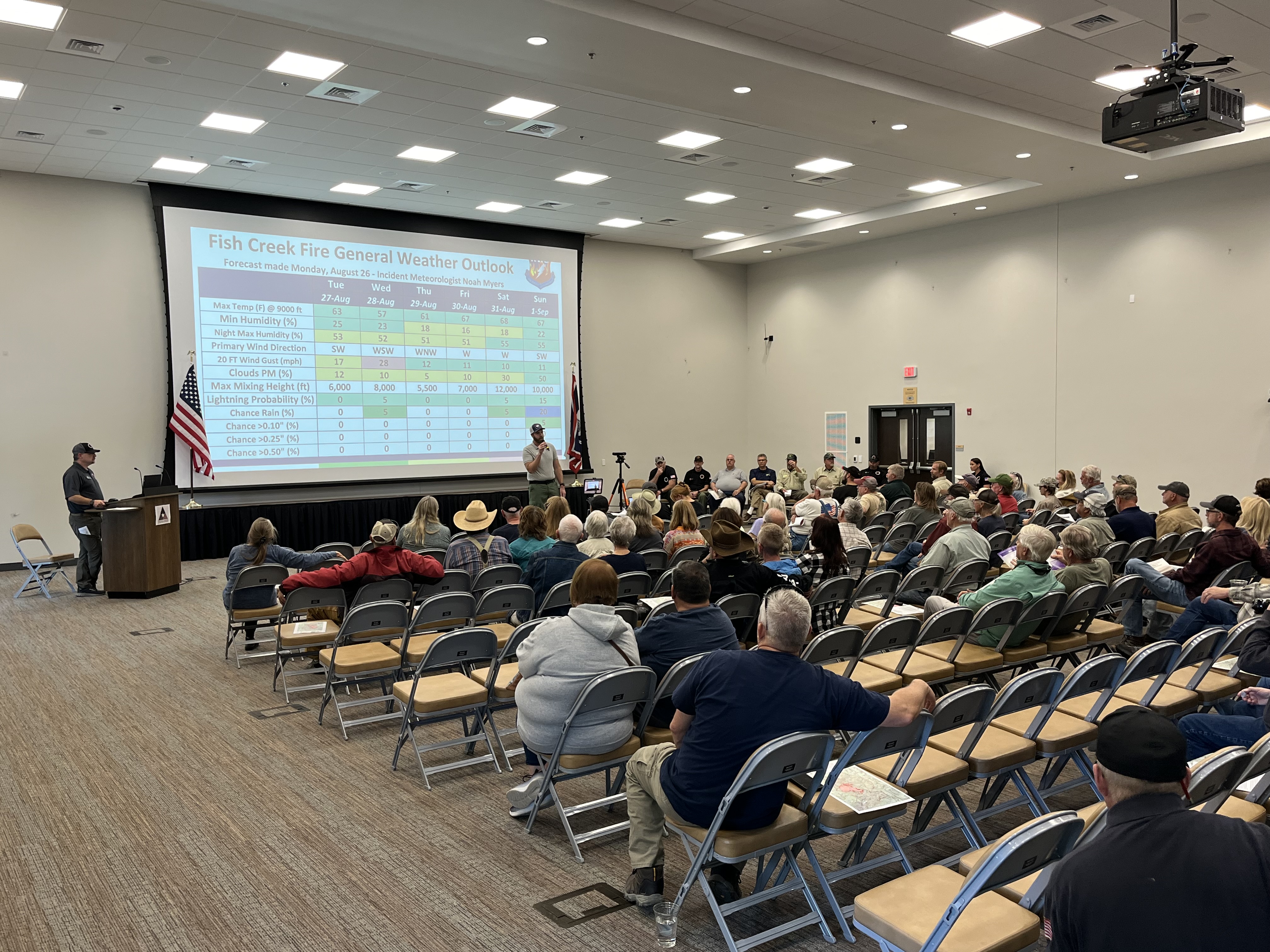
Fish Creek Public Meeting Recording 08 27 2024
Related Incident:
Publication Type: Announcement
The Fish Creek Fire public meeting was recorded and is available for view.
Fish Creek Public Meeting Recording- August 26, 2024
We heard from:
Noah Myers, the Incident Meteorologist
David Greathouse, Fire Behavior Analyst
Andy James, Northern Rockies Team 1 Operations Section Chief
Chief Ron Wempen of the Fremont Fire Protection District
Milan Vinich, Fremont County Emergency Manager
Jeff Von Kienast, Wind River District Ranger of the USDA Forest Service - Shoshone National Forest
Jason Wilmot, Blackrock District Ranger of the U.S. Forest Service-Bridger-Teton National Forest
with closing remarks from Brent Olson, Incident Commander of Northern Rockies Team 1
Followed by questions from the audience.
Additional information and resources available at: https://linktr.ee/NRTeam1

Park Fire Evening Update 08 26 2024
Related Incident: Park Fire
Publication Type: News
Park Fire Evening Update for August 26 is posted on the Park Fire Status Update Page
Boise County Sheriffs Office Evacuation changes 08 27 2024
Related Incident:
Publication Type: Announcement
The Boise County Sheriff's Office is making changes and upgrading subdivisions due to increased fire activity. Additionally, they are placing all homes along the Highway 21 corridor from milepost 82 to 85 under a Level 1 evacuation alert, advising residents to be prepared.
See the full post including graphic on Boise Sheriff Facebook page.
Wapiti Fire Community Meeting Tuesday 08 27 2024
Related Incident:
Publication Type: Announcement
Wapiti Fire Community Meeting
Tuesday, August 27, 2024, 6 p.m.
Lowman Fire Station, 8000 ID-21, Lowman, Idaho
The Rocky Mountain Complex Incident Team 1 members and local authorities will provide information on the status of the Wapiti Fire. An update on the Middle Fork Complex will also be provided by Great Basin Complex Incident Team 3.
There will also be a virtual option, if internet service allows. The meeting will be livestreamed, and the recording later posted to the Wapiti Facebook Page. https://facebook.com/wapitifireinfo2024
Fire Behavior change Evening 08 26 2024
Related Incident:
Publication Type: Announcement
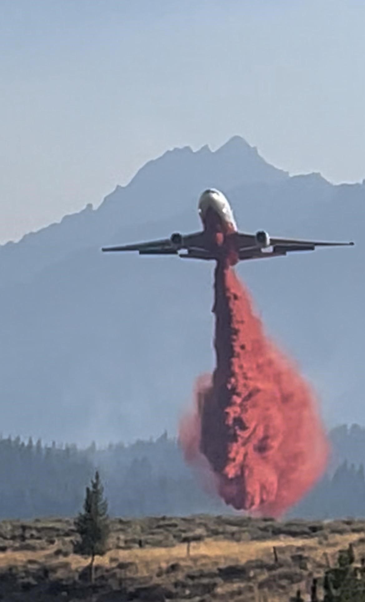
Fire activity has increased on the Wapiti Fire and the fire is moving into Crooked Creek. A very large air tankers (VLAT) and large air tankers (LAT) have been ordered to create a retardant line south of Iron Creek and east of highway 21. This retardant line will also serve as a line between the fire and Stanley.
Crews will begin defensive firing operations this evening and tonight in an attempt to create a defensible line between the approaching fire and the values at risk. With temperatures increasing, fuels drying, increased sunlight, and winds expected to shift out of the northwest tomorrow, fire managers feel this is the best opportunity to create a defensible space around structures and other values northwest of Stanley.
Aircraft – both helicopters and air tankers – will be active northwest of Stanley this afternoon and this evening. Smoke production is expected to increase and flames will be visible this the evening into the night.
Park PostFire BAER Soil Burn Severity Map Released 08 26 2024
Related Incident: Park Post-Fire BAER
Publication Type: News
Park Post-Fire BAER Soil Burn Severity Map Released
August 26, 2024
Forest Service Burned Area Emergency Response (BAER) and California State Watershed Emergency Response Team (WERT) specialists recently coordinated and completed their data gathering and analysis for the Park Fire burned area to produce a soil burned severity (SBS) map. The development of the SBS map for the Park Fire was an interagency collaboration between California WERT and the Park BAER team.
This soil burn severity map and data display categories of unburned/low, moderate, and high. Approximately 57% of the total 430,933 acres analyzed by the BAER team are either unburned and/or low soil burn severity, while 36% sustained a moderate soil burn severity, and about 7% identified as high soil burn severity. NOTE: As of August 26, 2024, InciWeb Park Fire information currently shows the fire at 82% containment and 429,603 acres.
There are several types of fire severity and intensity maps that you may see. Although they look different for the same fire, they may also all be accurate. This is because fire severity or intensity are different measures of the fire effects on a specific resource such as soils, tree canopies, vegetation or wildlife habitat. Burned Area Emergency Response (BAER) maps are primarily measures of fire effects on soils.
The BAER assessment team used initial remote sensing imagery with their field validated soils data, to develop and produce a map showing soil burn severity levels for the burned areas The SBS is broken into four different classes: unburned (green), low severity (blue), moderate severity (yellow), and high severity (red). For more information on what these different SBS classifications mean, see BAER Information Brief at: Calnf Park Postfire Baer - | InciWeb (wildfire.gov).
The BAER team rely on their refined soil burn severity map to produce data which they are using in their subsequent modeling and determination of post fire runoff and sedimentation. The BAER teams and the US Geological Survey (USGS) both utilize the soil burn severity map as an analysis tool to estimate post-fire flows and debris flow probability. In specific areas that experienced moderate to high burn severity, there could be increased runoff from steep hillslopes and resultant increases in post-fire soil erosion and potential debris flows.
The Park soil burn severity (SBS) map can be downloaded at the Park Post-Fire BAER InciWeb site: Calnf Park Postfire Baer Information | InciWeb (wildfire.gov) as a JPEG or PDF version under the “Maps” tab.
BAER SAFETY MESSAGE: Everyone near and downstream from the burned areas should remain alert and stay updated on weather conditions that may result in heavy rains and increased water runoff. Flash flooding may occur quickly during heavy rain events--be prepared to act. Current weather and emergency notifications can be found at the National Weather Service website: www.weather.gov/sto/.
###