
RailroadDaly Fire Area and Road Closure 08 26 2024
Related Incident:
Publication Type: Closures
Order Number: 24-D2-02
U.S. Department of Agriculture, U.S. Forest Service
Bitterroot National Forest
Darby-Sula Ranger District
Railroad and Daly Creek Fires -Area and Road Closure
Pursuant to 16 U.S.C. § 551 and 36 C.F.R. § 261.50 (a) and (b), the following is prohibited on the National Forest System (NFS) roads and trails on the Darby-Sula Ranger Districts, Bitterroot National Forest, described below and shown on the attached map incorporated into this Order as Exhibit A (the "Described Area"):
PROHIBITIONS
Going into or being upon the area described in the Order. 36 CFR 261.53(e) Being on the road. 36 C.F.R. § 261.54(e).
Being on the trail. 36 C.F.R. § 261.55(a).
EXEMPTIONS
Pursuant to 36 C.F.R. § 261.50(e), the following persons are exempt from this Order:
1. Any Federal, State, or Local Officer, or member of an organized rescue or firefighting resource in the performance of an official duty.
2. Persons with a Forest Service special use authorization • or other authorization specifically exempting them from the effect of this Order.
DESCRIBED AREA
The boundary of the closed area, as further depicted on Exhibit A, starts at junction of FS Road 75 and FS Road 62736 in the NW ¼ of Section 20 T 4N R 18W proceeding 4.5 miles down Trail 87 to Junction with Trail 313, SE to Rooster Comb in Section 2 T3N R18W. Progressing North from Trail 313 along Forest Boundary 15 miles to Section 11 T5N .R1 SW. Connecting NW for 1 mile from Trail 313 to FS Road 62618 at Section 3 T5N R1 SW. Continuing SW along FS Road 62618 for 2.5 miles to Section 9 T5N R1 SW at Junction of HWY 38 and FS Road 711. Additionally, from Junction of FS Road 75 and FS Road 720 in NE¼ Section 7 T4n R1 SW for 3 miles to Eastern Portion of Section PB38 T4N R1 SW at FS Road 1370 Junction progressing North along FS Road 1370 to Trail 154 at Section PB46 T5N R19W 5 miles to Junction of FS Road 75 and HWY 38. All roads and trails described above and otherwise within the described area are closed.
PURPOSE
The purpose of this Order is to ensure public health and safety during fire suppression efforts of the Railroad and Daly Creek Fires.
IMPLEMENTATION:
This Order shall be in effect from August 26th, 2024 at 0600 until rescinded or until October 31, 2024 at 0001, whichever occurs first.
A map identifying the Described Roads and Trails is attached and made part of this Order as Exhibit A. For a digital version of this Order and Exhibit A, go to https://www.fs.usda.gov/bitterroot . Unless otherwise expressly defined in this Order, the terms used in this Order are defined by the regulations of the Secretary of Agriculture, 36 C.F.R. Chapter II, Parts 200-299. If there are terms in this Order that are not expressly defined in the Order or 36 C.F.R. Chapter II, Parts 200-299, their meaning shall be determined by their plain language definitions.
A violation of the above prohibitions is punishable as a Class B misdemeanor by a fine of not more than $5,000 for individuals and $10,000 for organizations, or by imprisonment for not more than six months, or both. 16 U.S.C. § 551; 18 U.S.C. §§ 3559, 3571, and 3581.
Contact the Darby-Sula Ranger District in Darby, MT, (406) 821-3913, or Bitterroot National Forest Supervisor's Office in Hamilton, MT, (406) 363-7100, for more information about this Order.
This Order supersedes any previous Orders prohibiting the same or similar acts in/on the same Described Area/Roads/Trails.
Signed and Issued on 8/26/2024
Matt Anderson, Forest Supervisor, Bitterroot National Forest
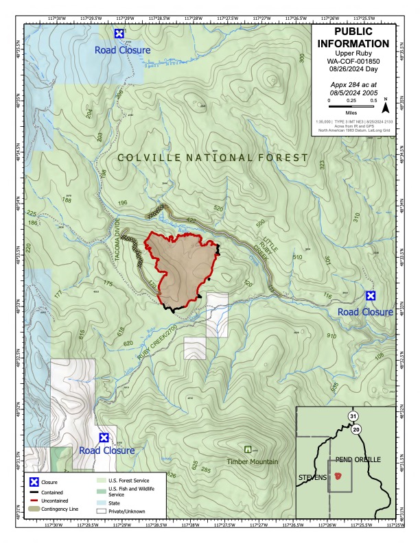
Upper Ruby Fire Daily Update 08 26 2024
Related Incident:
Publication Type: News
Upper Ruby Fire Daily Update
August 26, 2024
Containment: 16%
Fire Perimeter: 284 acres
Initial Start: 08/20/24
Location: Ruby Creek Drainage - approximately 16 miles northwest of Cusick, WA
Hazards: hot ash pits, timber snags, bees, and narrow roads
Values at Risk: Private residences, ongoing timber sales
Cause: Undetermined
Personnel: approximately 240
Structures destroyed: 0
Evacuations: None
Road Closures: Ruby Creek Road (5.5 miles in from Hwy 20), Tacoma Creek Rd (about 11 miles west of Hwy 20), and Tacoma Divide Road (about 4 miles south of Hwy 20)
Ione, WA – PUBLIC AND FIREFIGHTER SAFETY IS THE NUMBER ONE PRIORITY.
The Upper Ruby Fire is in central Pend Oreille County approximately 16 miles northwest of Cusick, WA. It is burning in fuels remaining on the ground following logging activities and in heavily forested areas.
OPERATIONS: Yesterday, firefighters installed several thousand feet of firehose along the steep west flank of the fire. They filled porta-tanks with water tenders and used hose to get water onto the constructed fireline. On the east flank, a similar operation used over 10,000 gallons of water each day for the last 3 days along a ½ mile section of constructed fireline to extinguish hot spots deep in the duff layer. On the north and west sides of the fire, in addition to mopping up along the fire edge, crews completed contingency control lines by extending the Little Ruby Creek and170 roads with dozer line. These contingency lines were built in case fire was to escape the primary direct fireline.
It was determined the fire remained within primary control lines following the recent wind event, but that the accompanying rain did little to extinguish hot spots deep in the duff layer.
Today, crews will use six-wheel drive tactical water tenders and skidgeons (small all-terrain water tenders) to fill porta-tanks in remote areas of the fire. Firefighters will pump water around the control line from porta-tanks to charge their hoses. They use them to continue the arduous work of extinguishing extremely hot embers burning over 18 inches deep in the duff layer.
HAZARDS: Hazards to firefighters include hot ash pits, unstable footing, fire-weakened and standing dead trees (snags) and a very high population of ground nesting bees. Yesterday, firefighters practiced a mock injury and extraction using equipment and expertise provided by the onsite Rapid Extraction Module (REM). This provided crews with experience to safely transport a fellow firefighter in case of an actual severe injury.
WEATHER: Dryer, warmer weather is expected today, with possible cooler, wetter weather on Tuesday. Light winds are predicted.
Inciweb: https://inciweb.wildfire.gov/incident-information/wacof-upper-ruby
Facebook: https://www.facebook.com/newfireinfo
Phone: 509-990-6218 (hours 8 am – 8 pm)

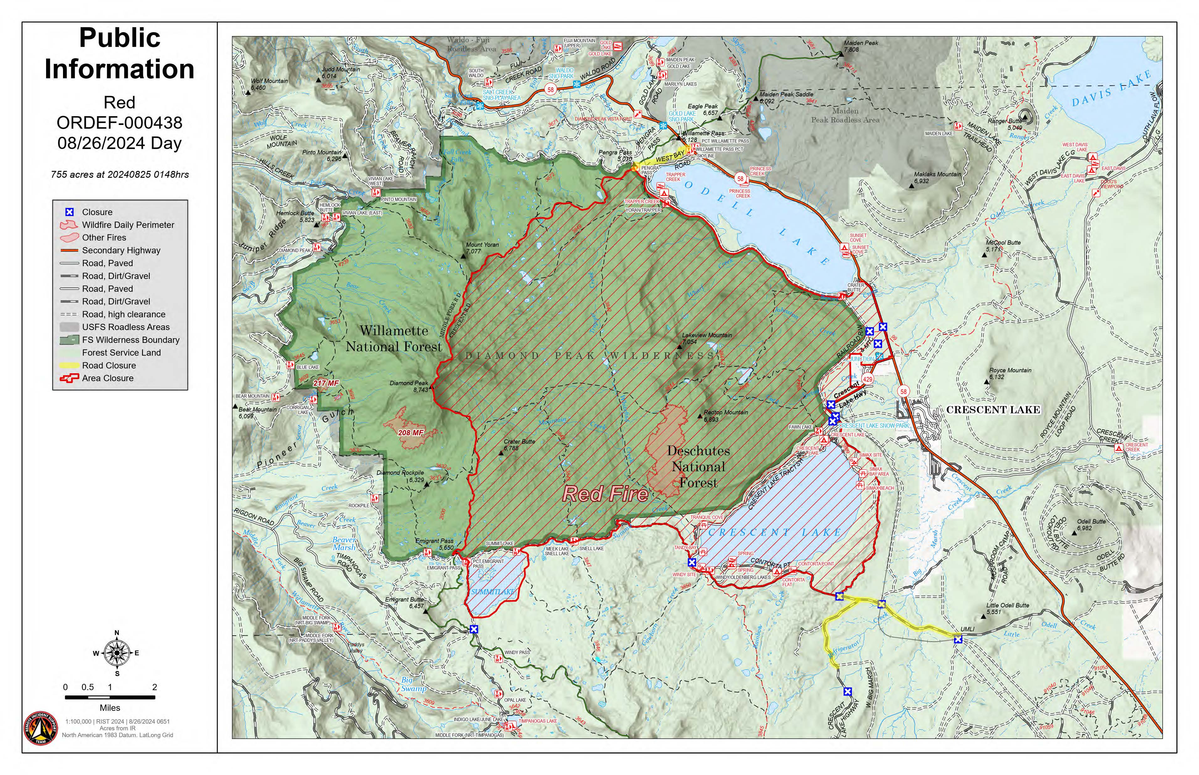
August 26 2024 Red Fire Daily Update 08 26 2024
Related Incident: Red Fire
Publication Type: News
Size: 753 acres Location: 5 miles west of Crescent Lake Junction, OR County: Klamath. Start Date: July 17, 2024 Cause: Lightning Containment: 0% Total Personnel: 185
Crescent, OR – The Red Fire is burning on the southwest slope of Redtop Mountain within the Diamond Peak Wilderness on the Deschutes National Forest
Activities – Fire personnel continue to improve the shaded fuel breaks between Crescent Lake and Summit Lake. Work will continue to the northwest of Summit Lake constructing the shaded fuel break along Forest Service Road FSR 6010 and towards FSR 380 on the Willamette National Forest to connect with the suppression work being done by the 208 MF Fire. Log trucks and other heavy equipment have started work at 4:30am to support hauling operations.
Incident Strategy- An assessment by the initial attack incident commander, local fire managers, and Forest staff determined the risk to responders was too great to continue with direct attack due to firefighter safety concerns including a lack of escape routes and safety zones, snag hazards, and the remote location of the fire. Currently, a full suppression strategy is being implemented utilizing shaded fuel breaks. Fire managers are continually reevaluating the safest, most effective suppression strategy based on changing weather, fuel conditions, and fire behavior. Firefighter and public safety remain the management team’s highest priority in managing this fire.
Closures -To provide for the safety of our staff, equipment operators, and public the Deschutes National Forest emergency closure around Crescent Lake and in Diamond Peak Wilderness is still in effect, include these areas: FSR 60 is closed, and road guards have been posted for public safety. More closure information is available at: https://www.fsa.gov/alerts/deschutes/alerts-notices/?aid=89091
Weather and Smoke – The low pressure system moved out of the area and a warming and drying trend starts in the coming week. Precipitation over the last three days was not enough to significantly wet the interior of larger fuels such as standing dead trees and fallen logs.
Evacuations – The WILDFIRE! Level 1 – BE READY to Evacuate notice issued by Klamath County Emergency Management for Crescent Lake, Odell Lake, and Crescent Junction areas remains in effect (INCENDIO FORESTAL! Nivel 1 - ESTÉ PREPARADO para evacuar de las siguientes zonas: Crescent Lake, Odell Lake, Crescent Junction). Visit www.klamathcounty.org/300/emergency-management for more information or to sign up for alerts.
Fire Restrictions – Stage 2 Public Use Fire Restrictions – which prohibit open fires, including in developed campgrounds – remain in effect for the Deschutes National Forest. The Industrial Fire Precaution Level is currently Level III “Partial Shutdown.” Visit fs.usda.gov/detail/deschutes/home/?cid=stelprdb5297376 for more information.
Drone Restrictions – Aerial firefighting is suspended when unauthorized drones (UAS) are in the area. Unauthorized drone use over a fire area poses serious risks to fire personnel and the effectiveness of wildfire suppression operations. If you fly, we can’t.
Actualizacin del incendio Pioneer 26 de agosto de 2024 08 26 2024
Related Incident:
Publication Type: News
Actualización del incendio Pioneer
26 de agosto de 2024
Datos clave
Tamaño: 38,735 acres
Fecha de inicio: 8 de junio de 2024
Ubicación: 31 millas al NO de Chelan, WA
Contención: 23%
Personal: 414
Causa: A ser determinada
Recursos asignados: 8 equipos de obreros, 6 helicópteros, 7 camiones de bomberos, 17 tanques de agua, 8 maquinarias pesadas
SITUACIÓN ACTUAL: Hoy, los bomberos llevaron a cabo patrullajes terrestres y aéreos sobre el incendio Pioneer tras el sistema de tormentas que resultó en más de una pulgada de lluvia sobre el área del incendio. Se vio una pequeña sección de calor en el interior del pozo del desague de Little Boulder dentro de las características de retención existentes. Los recursos terminaron de remover el exceso de equipo por barco y aeronave y llevaron a cabo trabajos de reparación por la extinción para estabilizar las características de retención y prevenir la posible erosión del suelo. Los vuelos que se realizaron sobre los incendios de Rennie, McAlester y Flat Creek mostraron que había una sección pequeña de calor en el incendio Flat Creek. Los tres incendios han permanecido dentro de sus huellas existentes durante los últimos días.
Ya está abierto Stehekin a los visitantes. Permanecen muchos peligros relacionados con incendios en el área y los servicios pueden ser limitados o alterados. Además, permanecen cerrados muchos senderos y campamentos debido a estos peligros. Los visitantes deben confirmar los servicios que están disponibles antes de viajar.
ACTIVIDADES DE HOY: Los bomberos están realizando reparaciones por la extinción en la línea manual en las áreas de Moore Point y Stehekin Landing. Las cuadrillas siguen transportando moviendo mangueras y equipos alrededor de Safety Harbor. Los bomberos en el área de Cooper Ridge están triturando y removiendo los escombros de vegetación. Los recursos al sur del incendio cerca de Manson están reparando las carreteras por el tráfico de incendios. A medida que disminuye la intensidad del fuego, el exceso de equipos y recursos se retira del incidente. Los bomberos permanecen listos para ayudar con posibles inicios de fuegos nuevos.
CLIMA: Los cielos parcialmente nublados con vientos crecientes por la tarde traerán otro sistema meteorológico a la zona junto con probabilidad de lluvia. El martes por la tarde, empieza una tendencia de calentamiento y sequía.
EVACUACIONES: Para ver los niveles de evacuación actuales, visite la página de Facebook del Departmanto de gestión de emergencias del condado de Chelan en facebook.com/CCSOEM o vea el https://chelangis.maps.arcgis.com/apps/instant/media/index.html?appid=ca1e19e4123b4002a9fb176b25434e03/.
CIERRES: Permanecen cerrados muchos senderos y campamentos. Consulta los cierres actuales para el Parque Nacional de las Cascadas del Norte en: https://www.nps.gov/noca/index.htm y el Bosque Nacional de Okanogan-Wenatchee: https://www.fs.usda.gov/alerts/okawen/alerts-notices. Las fogatas están prohibidas. El sendero Pacific Crest Trail está cerrado en áreas de Washington debido a varios incendios forestales. Para obtener más información, visite: closures.pcta.org/. Hay una Restricción Temporal de Vuelo (TFR, por sus siglas en inglés) sobre el incendio: tfr.faa.gov/save_pages/detail_4_2248.html. La actividad no autorizada con drones está prohibida por la TFR.
InciWeb: https://inciweb.wildfire.gov/incident-information/wases-pioneer
Facebook: https://www.facebook.com/profile.php?id=61560760893080
Línea de información sobre el incendio: 541-861-5808, de 8 AM a 8 PM
Correo electrónico: 2024.pioneer@firenet.gov
McElwain Fire Update 08 26 2024
Related Incident:
Publication Type: Announcement
Location: 10 miles west of Helmville, Montana
Start Date: 8/23/2024
Cause: Lightning
Size: 176 acres
Containment: 0%
CURRENT STATUS
The McElwain Fire, located by McElwain Creek 10 miles west of Helmville in Powell County is currently 176 acres in size. The fire is burning in grass and timber on private and Bureau of Land Management land under Montana DNRC wildland fire protection. The fire is comprised of two adjacent fires, a north fire, and a south fire. Fire behavior includes creeping and smoldering with isolated torching. Control line has been established by heavy equipment around the south fire and where access has allowed on the north fire. Firefighters will work today to complete one last section of control line on the north fire after fallers remove dangerous snag trees in the area. Progress was made yesterday on securing existing control line by mopping up (extinguishing all flame and heat) 20-30 feet deep, and work will continue today to mop up one chain (66 feet) deep and contain and control spot fires as detected. The fire remains at 0% containment with the anticipation that this will increase as line is completed and secured. Containment measures confidence that the control line will effectively halt fire spread.
A Type 3 Incident Commander (IC) is in place and resources include four engines, three Type 2 hand crews, one eight-person hand crew (Module), one water tender, four skidgines, and one dozer. A Type 2 DNRC helicopter provided bucket drop support yesterday as needed and will be available this afternoon for support as well. It was determined that lightning caused the fire.
WEATHER
Drier conditions and light, variable winds are expected throughout the area today. Firefighters are working hard to secure the fire ahead of a relatively dry cold front expected tomorrow that could bring with it an increase in west winds with gusts from 25 to 35 mph. Much cooler temperatures are expected post frontal.
EVACUATIONS AND CLOSURES
The Powell County Sheriff’s Office has issued evacuation warnings to residents in the immediate area of the fire, specifically the Ledger Road area. This is a limited warning for residents in the immediate area. Please visit the Powell County Sheriff’s Office Facebook page for specific information and updates.
ADDITIONAL AREA FIRES
The Hoodoo Fire is a six-acre lightning caused fire on Hoodoo Mountain seven miles southeast of Helmville. Burning in steep, difficult terrain with scree and heavy dead and down timber, six firefighters are working to contain the fire and have improved a helispot so additional firefighters and supplies can be shuttled in. The Weasel Fire, just west of the McElwain Fire has been controlled and is in patrol status. Both fires are on BLM land under DNRC wildland fire protection.
Powell County is currently in Stage 1 fire restrictions. Residents and visitors are asked to be extra careful when outdoors to limit human caused sparks. We cannot control the lightning, but we can prevent unintended human caused wildfires. Visit www.MTFireInfo.org for specific fire restriction information and fire prevention tips.
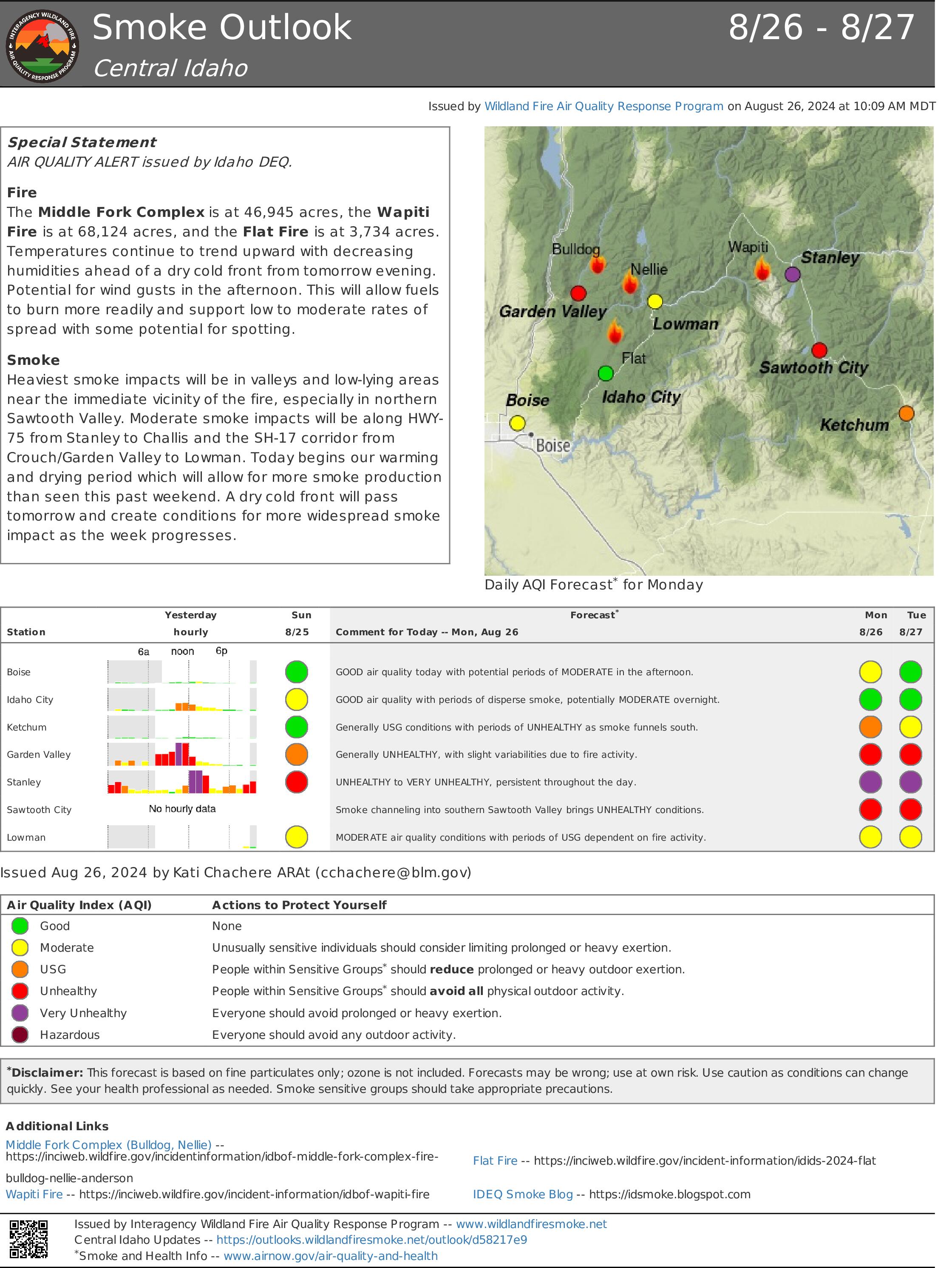
Wapiti Fire Update 08 26 2024
Related Incident:
Publication Type: News
![]()
Wapiti Fire Update
Monday, August 26, 2024 – 9:00 a.m.
Rocky Mountain Complex Incident Management Team 1
Dan Dallas, Incident Commander
Information Phone: 208-593-7132 Hours: 8 a.m. to 8 p.m.
Email: 2024.wapiti@firenet.gov
InciWeb: https://inciweb.wildfire.gov/incident-information/idbof-wapiti-fire
Facebook: https://www.facebook.com/wapitifireinfo2024/
Information Linktree: https://linktr.ee/WapitiFireInfo2024
Special Notes: Rocky Mountain Complex Incident Management Team 1 (RM CIMT1) hosted a community meeting Sunday, August 25, 2024, at the Stanley Community Building in Stanley, ID. A recording of the meeting can be viewed on our Facebook page Wapiti Fire Information 2024 (see link above).
A second community meeting will be held at the fire station in Lowman at 6:00 pm on Tuesday, August 27. An update on the Middle Fork Complex will also be provided by Great Basin CIMT3.
State Highway 21 is closed from east of Lowman to Stanley (MP84 to MP130) due to wildfire activity. The closure is necessary for public safety and to provide safe conditions for firefighters working along the highway.
Current Situation: On Sunday, cloud cover moved out earlier than expected and fire activity picked up. Firefighters continued prepping around structures in the subdivisions near Stanley as well as along Highway 21 towards Lowman. The fire is now 68,124 acres, having moved very little over the weekend. The suppression focus is on protecting structures and communities with dozer and hand lines, air resources, and establishing hose lays, and then strengthening these efforts with strategic firing operations. The overall strategy remains full suppression of the fire. All activities are being coordinated on the ground with Resource Advisors to protect known values.
Division KK and Structure Group East: Crews will continue to mop up around structures in the Cow Camp area. The fire has been slowly backing down towards Highway 21. Yesterday and last night, crews burned out along Highway 21 north of Homestead, bringing the fire around Homestead and strengthening the protection features around the community. The structure group is continuing prep work around Crooked Creek, Iron Creek, and Goat Falls communities. Crews are working to get this work done before the anticipated winds shift later in the week, which could push the fire in a southeasterly direction. These firelines have been plumbed with hose lays, supported with water tanks, pumps, and sprinkler systems.
Division PP: Work continues to clear trees along the Highway 21 corridor and mop up the areas where the fire crossed the road. The objective is to open the highway for safe travel for incident resources, mop up around structures, and establish containment lines to prevent future fire growth.
Division MM: Fire managers are assessing and implementing point protection around values at risk in the Bull Trout Lake area. They will be focusing their efforts around the Boy Scout Camp and campground. It is anticipated that fire activity will pick up in this area today and strategic firing operations may be initiated to protect these values.
Division WW and Structure Group West: The fire is slowly backing into the Warms Springs drainage and fire managers are evaluating opportunities to conduct strategic firing operations to bring the fire down to the bottom of the drainage. Crews are assessing and implementing plans around the subdivisions of Two Ravens, Ten Ax, and Seven Peaks to begin point protection work. They will also continue mopping up around structures in Hanging Valley and Bear Valley, along the 524 road and the Grandjean area. Fire managers are continuing to work with the Lowman Fire Chief to assess values at risk, point protection needs, and containment opportunities in the area between Warm Springs and Lowman along the Highway 21 corridor.
Weather, Fuels, and Fire Behavior:
Temperatures should continue to warm throughout the week and humidities will decrease. Cloud cover will clear out, allowing for fine dead fuels to dry and warm. This will increase fire behavior, resulting in the potential for increased rates of spread, torching, and spotting.
Evacuations:
For evacuation information on the Wapiti Fire, please see the Custer County Sheriff’s Facebook page at https://www.facebook.com/p/Custer-County-Sheriff-Idaho-61558947312289/ and the Boise County Sheriff’s Facebook page at https://www.facebook.com/boisecountysheriff/.
Red Cross is prepared to establish a shelter in Challis, ID if necessary.
To sign up for Custer County CodeRED emergency notifications, text CUSTER to 99411 or enroll online at https://public.coderedweb.com/CNE/BF28E45537FF .
Closures and Fire Restrictions:
State Highway 21 is closed from MP84 to MP130 for public and firefighter safety.
A Wapiti Fire Area Closure / Forest Order: 0402-05-95 for portions of the Boise, Sawtooth, and Salmon-Chalis National Forests can be found at this site: https://www.fs.usda.gov/alerts/boise/alerts-notices .
Boise National Forest Stage 1 Fire Restrictions / Forest Order: 0402-00-63 can be found at this site: https://www.fs.usda.gov/alerts/boise/alerts-notices .
Sawtooth National Forest Stage 1 Fire Restrictions / Forest Order 0414-00-044 can be found at this site: https://www.fs.usda.gov/alerts/sawtooth/alerts-notices .
Fire restrictions on state and private lands may be found at this site: https://www.idl.idaho.gov/fire-management/fire-restrictions-finder/ .
A Temporary Flight Restriction is in place over the Wapiti Fire. Wildfires are a no-fly zone for unauthorized aircraft, including drones. If you fly, we can’t. For more information, visit http://knowbeforeyoufly.org.
Wapiti Fire Statistics:
Size: over 68,124 acres
Containment: 0%
Total Personnel: 522
Location: Grandjean, ID
Reported: July 24, 2024
Cause: lightning
For More Information:
Information Phone: 208-593-7132
Email: 2024.wapiti@firenet.gov
InciWeb: https://inciweb.wildfire.gov/incident-information/idbof-wapiti-fire
Facebook: https://www.facebook.com/wapitifireinfo2024/
Linktree: https://linktr.ee/WapitiFireInfo2024
###
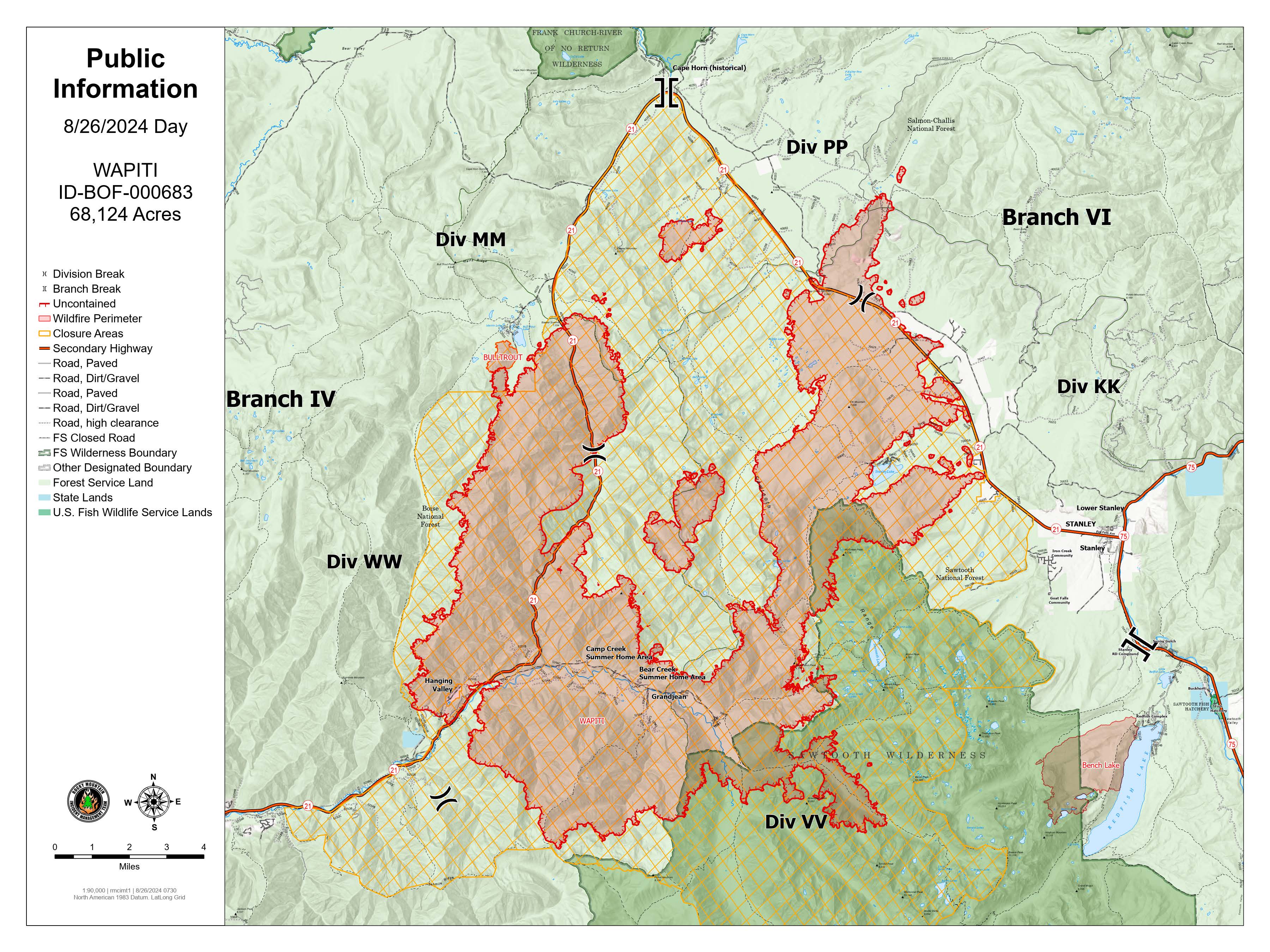
Wapiti Fire Map 8-26-24
2620 Road Fire Update 08 26 2024
Related Incident: 2620 Road Fire
Publication Type: News
2620 Road Fire
Incident Commander: Kent Stanford/Blair Joiner
Fire Information Phone Number: 360-323-1903
Email: 2024.2620Road@firenet.gov
Facebook: www.facebook.com/2620RoadFire2024
InciWeb: https://inciweb.wildfire.gov/incident-information/waolc-2620-road-fire
Update as of: August 26, 2024
Estimated size: 403 acres
Containment: 81%
Start Date/Time: 8/14/2024 at 5:00 PM
Area of Origin: West of Brinnon, North of Duckabush Rd. on Mt. Jupiter
Cause: Undetermined
Structures Damaged: None
Road Closures: Duckabush Road is now open!! Mt. Jupiter Road will remain closed to the general public.
Evacuation Levels: all evacuation levels have been rescinded.
Update: Containment has risen to 81%! Crews continued to make incredible strides yesterday increasing fire containment. Resource needs are being constantly evaluated, some crews are being moved from one area to another, while some are being released. Many of the extensive hose lays are being moved to other areas of the fire, or if no longer needed, are being hauled off the mountain. The hard work of the crews during mop up still continues around the fire, and some areas have moved into “patrol status”.
Once the arduous mop up work is done in one area, it moves to a new status of “patrol”. During patrol, the fire area is still heavily watched each day, but no physical action is taken unless a smoking area or a hazard is seen. Patrol is a valuable tool that frees up firefighters and equipment to go to other locations on the fireline that still need work, yet provides eyes on the fire to closely monitor it for any changes, and take immediate action if needed.
The transition to a Type 4 Commander, governed by WA DNR, is well underway. The new Incident Commander is already familiar with the fire and what resources are in place, or scheduled to depart. The incoming ICT 4 and will be supported by a subset of the fire resources already in place.
Air Restrictions: The Temporary Flight Restriction (TFR) 4/2969 remains in effect for the fire area. Remember, If you fly, we can’t!!
Weather: The weather pattern will be warming with lessening chance of rain through the upcoming week.
Forest Closures: Olympic National Forest closures are located at www.fs.usda.gov and Olympic National Forest – Alert and Closures web page
Homestead Complex Fire Update 08 26 2024
Related Incident:
Publication Type: News
Homestead Complex Fire Update for Monday, August 26, 2024
No Man, Salmon 33, Horse Heaven Creek, Bullpup, Fuller Lake, Reynold’s Butte, Lost Bucket
Start date: July 19, 2024 | Location: Northeast of Glide, Oregon | Total Personnel: 961 Total Homestead Complex Fire size: 5,898 acres | Cause: Lightning | Containment: 47%
Summary
Regarding fire suppression efforts, Operations Section Chief Manny Mendoza stated, “things are going good” as shown by progress in containment. Additionally, these efforts are helping with the incident objective to protect steelhead trout spawning grounds.
No Man (2,080 acres): A lot of good work is being done on No Man. Crews are continuing with forest rehabilitation as well as patrolling and mop-up. Drones were used today searching for hot spots.
Horse Heaven Creek Fire (2,295 ac.): Containment grew significantly on the east side and crews are working to open roads on the west. The hazards of hot spots remain and crews are diligently assessing those areas.
Bullpup Fire (476 ac.) and Fuller Lake Fire (418 ac.): Hotshot crews began to put a direct handline on the northern edge of the fire, one going east, and the other towards the west. The focus on the Fuller Lake Fire remains to prep primary and secondary control lines, chipping and patrolling.
Salmon 33 (261 ac.) 100% contained on August 24, 2024.
Reynolds Butte Fire (334 ac): 100% contained on August 22, 2024.
Lost Bucket Fire (34 ac.): 100% contained on July 29, 2024.
Weather: High temperatures Monday will be in the 70’s and relative humidities in 40’s. Winds will be variable with gusts to 12 mph.
Closures and Fire Restrictions
The closure order issued by Bureau of Land Management (BLM), Roseburg District, for portions of BLM land which border the Umpqua National Forest Emergency Fire Closure north of Steamboat remains in effect. The closure order can be viewed here: https://www.blm.gov/sites/default/files/docs/2024-07/orwa-fpo-rbg- 072624.pdf.
The Umpqua National Forest has Emergency Fire Closures in place impacting every district of the forest. https://www.fs.usda.gov/alerts/umpqua/alerts-notices.
There is a Temporary Flight Restriction (TFR) over the Homestead Complex Fire. Please remember, if you fly we can’t! If a drone or other aircraft enters the air space, all firefighting aviation equipment will be grounded.
Fire Information Line: 541-208-7100 (Staffed 8 a.m. to 8 p.m.)
Willamette Complex South Daily Update for 08 26 2024
Related Incident: Willamette Complex Fires - South
Publication Type: News
Willamette Complex South Update
Chalk, Coffeepot, McKinley, Moss Mountain, Tire Mountain, 208, and 217 Fires
Online: https://inciweb.wildfire.gov/orwif-willamette-complex-fires-south
Facebook: https://www.facebook.com/WillametteComplexFires/
Email: 2024.willamettecomplex@firenet.gov
Monday, August 26, 2024
Total Willamette Complex South Personnel: 613
Total Willamette Complex South Acres: 13,064
Resources*: 1 Type 1 Hotshot Crew, 8 Type 2 Crews, 1 Type 2 Initial Attack Crew, 1 Helicopter, 21 Engines, 5 Dozers, 9 Masticators, 4 Skid Steer, and 6 Feller Bunchers (* The numbers include Pyramid Fire resources)
Fire Cause: Lightning
Summary
Lingering pockets of heat and smoke became more visible yesterday as conditions cleared. A helicopter provided water bucket drops along the south side of the Moss Mountain Fire yesterday to cool down hotspots that help hold the fire in place. Two helicopters will be available to the Willamette Complex South fires today. Firefighters will also be working with the un-crewed aircraft system (UAS)/drone to collect infrared information to detect heat throughout the footprint of the Moss Mountain Fire. A temporary flight restriction exists over the Willamette Complex South fires, including all personal drones. When you fly, we can’t!
Chalk Fire (5,684 acres, 66% containment)
Fire crews continued to monitor and improve containment lines on the south, east, and north portions of the fire. They also continue to improve and deepen completed direct lines on the western fire edge along Road 1912. Finally, firefighters continue to prep indirect lines and address fire-weakened trees and snags.
Moss Mountain Fire (864 acres, 0% containment)
Firefighters are securing spots south of Forest Service Road 2120, focusing on indirect tactics that involve heavy equipment to remove vegetation, woody debris and brush along the mountain road system. This work results in an effective fuel break. Crews continue to prep dozer lines along the north side of the fire.
208 Fire (252 acres, 0% containment)
The 208 Fire is being monitored and patrolled in the wilderness using aerial resources. When necessary, helicopters are using bucket drops to keep the fire in check.
217 Fire (38 acres, 100% contained), Tire Mountain Fire (23 acres, 100% contained), McKinley Fire (24 acres, 100% contained), Coffeepot Fire (6,179 acres, 100% contained)
The 217, Tire Mountain, McKinley, and Coffeepot fires are 100% contained and are patrolled regularly. Fire crews continue improving contingency lines established around the Coffeepot Fire.
Weather and Fire Behavior
Today, skies will clear with full sunshine by afternoon. High temperatures in the lower 60s, relative humidity near 60% and light winds are expected. Increasing warmer and drier conditions will persist throughout the week ahead. Recent precipitation with minimum relative humidity above 90% has limited fire activity to concentrations of large woody fuel.
Closures and Fire Restrictions
- For specific closure information, visit tinyurl.com/WillFireClosures2024
- For current fire restrictions, visit tinyurl.com/WillFireRestrictions2024
- Temporary Flight Restrictions (TFR): tfr.faa.gov for up-to-date areas. Wildfires are a no-fly zone for unauthorized aircraft, including drones. For more information, visit knowbeforeyoufly.org.
Pioneer Fire Update 08 26 2024
Related Incident:
Publication Type: News
Pioneer Fire Update
August 26, 2024
Quick Facts
Size: 38,735 acres
Start Date: June 8, 2024
Location: 31 miles NW of Chelan, WA
Containment: 23%
Personnel: 414
Cause: Under investigation
Resources Assigned: 8 crews, 6 helicopters, 7 engines, 17 water tenders, 8 heavy equipment
CURRENT SITUATION: Firefighters conducted on the ground and aerial patrols over the Pioneer Fire today following the last storm system that deposited over an inch of rain over the fire area. One small pocket of heat was identified in the Little Boulder drainage well interior of existing holding features. Resources completed backhaul of excess equipment by boat and aircraft and conducted suppression repair work to stabilize holding features and prevent potential soil erosion. Flights over the Rennie, McAlester and Flat Creek Fires revealed one small pocket of heat on the Flat Creek Fire. All three fires have remained in their existing footprints for the past several days.
Stehekin is now open to visitors. Many fire-related hazards remain in the area and services may be limited or altered. Additionally, many trails and campgrounds remain closed due to these hazards. Visitors should confirm available services before traveling.
TODAY’S ACTIVITIES: Firefighters are conducting suppression repair on hand line in the Moore Point and Stehekin Landing areas. Crews continue backhauling hose and equipment around Safety Harbor. Firefighters in the Cooper Ridge area are masticating and removing vegetation debris. Resources south of the fire near Manson are working on road repair from fire traffic. As fire activity decreases, excess equipment and resources are being released from the incident. Firefighters remain ready to assist with potential new fire starts.
WEATHER: Partly cloudy skies with increasing winds in the afternoon bringing another weather system into the area along with a chance of precipitation. A warming and drying trend begins Tuesday afternoon.
EVACUATIONS: To view the current evacuation levels, please visit the Chelan County Emergency Management Facebook page at facebook.com/CCSOEM or view the https://chelangis.maps.arcgis.com/apps/instant/media/index.html?appid=ca1e19e4123b4002a9fb176b25434e03/.
CLOSURES: Many trails and campgrounds remain closed. Check the current closures for the North Cascades National Park: https://go.nps.gov/fireclosures and Okanogan-Wenatchee National Forest: https://www.fs.usda.gov/alerts/okawen/alerts-notices before traveling to these areas. Campfires are prohibited. The Pacific Crest Trail is closed in areas across Washington due to multiple wildfires. For more information, please visit: closures.pcta.org/. There is a Temporary Flight Restriction (TFR) in place over the fire: tfr.faa.gov/save_pages/detail_4_2248.html. Unauthorized drone activity is prohibited under the TFR.
InciWeb: https://inciweb.wildfire.gov/incident-information/wases-pioneer
Facebook: https://www.facebook.com/profile.php?id=61560760893080
Fire Information Line: 541-861-5808, 8 a.m. to 8 p.m.
Email: 2024.pioneer@firenet.gov