
Homestead Complex Fire Update 08 25 2024
Related Incident:
Publication Type: News
Homestead Complex Fire Update for Sunday, August 25, 2024
No Man, Salmon 33, Horse Heaven Creek, Bullpup, Fuller Lake, Reynold’s Butte, Lost Bucket
Start date: July 19, 2024 | Location: Northeast of Glide, Oregon | Total Personnel: 1,062 Total Homestead Complex Fire size: 5,898 acres | Cause: Lightning | Containment: 47%
Summary
Yesterday, temperatures stayed relatively cool, allowing fire personnel to make great progress on containment. A warming trend will be making its way over the complex area, bringing warmer dryer conditions. However, Operations Section Chief Manny Mendoza says, “Fire behavior is somewhat benign.”
No Man (2,080 acres): A lot of good work is being done on No Man. Forest rehabilitation has started, mop-up and patrolling continues, and road grading is underway to repair damage from the rain and equipment.
Horse Heaven Creek Fire (2,295 ac.): Containment grew significantly on the fire, with the whole south perimeter getting checked-up. Excavation efforts will continue west of the fire, opening access along the ridge top. This will allow a Type 1 Hotshot Crew to get in and work along the north portion of the fire where terrain is steep and rough.
Bullpup Fire (476 ac.) and Fuller Lake Fire (418 ac.): Two Hotshot crews arrived today and will put in direct handline on the northern edge of the fire, one going east, and the other working their way west. The focus on the Fuller Lake Fire is to continue prepping primary and secondary control lines, chipping and patrolling.
Salmon 33 (261 ac.) 100% contained on August 24, 2024.
Reynolds Butte Fire (334 ac): 100% contained on August 22, 2024.
Lost Bucket Fire (34 ac.): 100% contained on July 29, 2024.
Weather: High temperatures will be in the mid 70’s in the valleys, with ridgetops reaching mid 60’s. Relative humidity will be in the upper 30’s. Overnight humidity recoveries will be 90%. Wind NW 4-8.
Closures and Fire Restrictions
The Bureau of Land Management (BLM), Roseburg District, has issued a closure order for portions of BLM land which border the Umpqua National Forest Emergency Fire Closure north of Steamboat. The closure order can be viewed here: https://www.blm.gov/sites/default/files/docs/2024-07/orwa-fpo-rbg- 072624.pdf.
The Umpqua National Forest has Emergency Fire Closures in place impacting every district of the forest. https://www.fs.usda.gov/alerts/umpqua/alerts-notices.
There is a Temporary Flight Restriction (TFR) over the Homestead Complex Fire. Please remember, if you fly we can’t! If a drone or other aircraft enters the air space, all firefighting aviation equipment will be grounded.
Please scan the QR code below for more Homestead Complex Fire information, social media links, and resources.
Fire Information Line: 541-208-7100 (Staffed 8 a.m. to 8 p.m.)
August 25 2024 Daily Update 08 24 2024
Related Incident: Red Fire
Publication Type: News
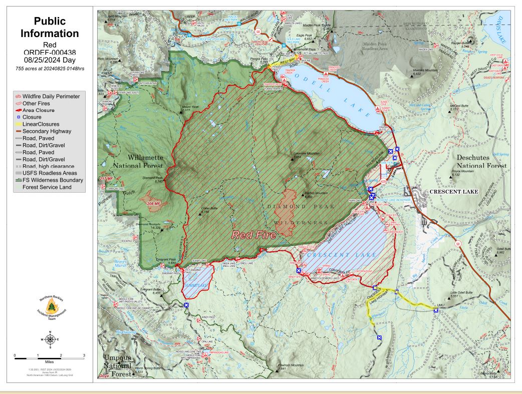
Size: 755 acres Location: 5 miles west of Crescent Lake Junction, OR County: Klamath
Start Date: July 17, 2024 Cause: Lightning Containment: 0% Total Personnel: 198
Crescent, OR – The Red Fire is burning on the southwest slope of Redtop Mountain within the Diamond Peak Wilderness on the Deschutes National Forest. An assessment by the initial attack incident commander, local fire managers, and Forest staff determined the risk to responders was too great to continue with direct attack due to firefighter safety concerns including a lack of escape routes and safety zones, snag hazards, and the remote location of the fire. Currently, a full suppression strategy is being implemented utilizing shaded fuel breaks. Fire managers are continually reevaluating the safest, most effective suppression strategy based on changing weather, fuel conditions, and fire behavior. Firefighter and public safety remain the management team’s highest priority in managing this fire.
Yesterday’s Activities – Fire personnel continued to improve the shaded fuel break between Crescent Lake and Summit Lake.
Today’s Activities – Fire personnel will continue work to the northwest of Summit Lake constructing the shaded fuel break along Forest Service Road FSR6010 and towards FSR 380 on the Willamette National Forest to connect with the suppression work being done by the 208 MF Fire. Log trucks and other heavy equipment will be starting work at 4:30am to support hauling operations.
Weather and Smoke – Last night the low pressure system deposited .75 inches of precipitation over the fire area. Precipitation over this period will not be enough to significantly wet the interior of larger fuels such as standing dead trees and fallen logs. The low pressure system moved out of the area this weekend and a warming and drying trend starts in the coming week.
Closures – The Deschutes National Forest emergency closure around Crescent Lake and in Diamond Peak Wilderness is still in effect. The public should note that FSR 60 is closed, and road guards have been posted for public safety. More closure information is available at: https://www.fsa.gov/alerts/deschutes/alerts-notices/?aid=89091
Evacuations – The WILDFIRE! Level 1 – BE READY to Evacuate notice issued by Klamath County Emergency Management for Crescent Lake, Odell Lake, and Crescent Junction areas remains in effect (INCENDIO FORESTAL! Nivel 1 - ESTÉ PREPARADO para evacuar de las siguientes zonas: Crescent Lake, Odell Lake, Crescent Junction). Visit www.klamathcounty.org/300/emergency-management for more information or to sign up for alerts.
Fire Restrictions – Stage 2 Public Use Fire Restrictions – which prohibit open fires, including in developed campgrounds – remain in effect for the Deschutes National Forest. The Industrial Fire Precaution Level is currently Level III “Partial Shutdown.” Visit fs.usda.gov/detail/deschutes/home/?cid=stelprdb5297376 for more information.
Drone Restrictions – Aerial firefighting is suspended when unauthorized drones (UAS) are in the area. Unauthorized drone use over a fire area poses serious risks to fire personnel and the effectiveness of wildfire suppression operations. If you fly, we can’t.
House Draw Fire Daily Update for August 25 2024 08 25 2024
Related Incident: House Draw Fire
Publication Type: News
Southwest Area Incident Management Team 5 assumes command of four northeast Wyoming/southeast Montana fires
Daily Update August 25, 2024
Fire Information Phone: 307-201-3885 (8am-8pm)
Media Information Phone: 307-543-7202 (8am-8pm)
Email: 2024.housedraw@firenet.gov
Acres: Flat Rock – 41,839; Remington – 184,127; Constitution – 12,080; House Draw – 174,448
Acreage changes may occur due to overnight operations and infrared mapping.
Containment: Flat Rock – 35% Remington – 0%; Constitution – 28%; House Draw – 88%
Location: Flat Rock – 11 miles NW of Gillette, WY; Remington – 20 NE of Leiter WY, multiple counties in SE Montana; Constitution – 15 miles north of Gillette, WY; House Draw – 40 miles southeast of Gillette, WY
Start Date: August 21, 2024 Personnel: 655 Fuels: Grass, brush and timber
Resources: 17 crews | 2 helicopters | 107 engines | 9 bulldozers | 2 water tenders
Highlights: On Sunday, August 25 at 6:00 a.m., Southwest Area Incident Management Team 5 assumed command of fires located in northeast Wyoming and southeast Montana, including the Flat Rock, Remington, Constitution and House Draw fires.
Fire Activity: Ground resources, including heavy equipment crews and firefighters are responding to the four fires currently burning in the area. Resources on the ground will utilize direct and indirect attack tactics to respond to on-going fire threats. Brief updates are provided for each incident.
Flat Rock – Firefighters observed extreme behavior on Flat Rock fire on Saturday, August 24. The fire area encompasses challenging and inaccessible terrain and hot, dry and windy conditions are expected today as crews utilize direct and indirect tactics.
Remington – Extreme fire behavior was observed on the Remington fire on Saturday, including wind-driven runs, torching and spotting. Today, crews will secure containment lines and protect values at risk including infrastructure and structures.
Constitution – Today, heavy equipment crews will construct line on the north side of the Constitution fire (towards Horse Creek). Fire fighters will scout additional anchor point(s) on the east flank, moving north to protect values and communities at risk.
House Draw – The House Draw fire experienced minimal fire behavior on Saturday. Today, firefighters will mop-up, extinguish hot spots and secure the fire perimeter.
Evacuations: An evacuation notification is in place for Sheridan County, Wyoming. No active evacuation orders are in place for Johnson or Campbell Counties, Wyoming. A Level 2 evacuation notice is in effect in for Big Horn, Rosebud, and Powder River Counties in Montana.
Weather: Hot, breezy conditions will exist across the region.
Fire Restrictions and Closures: Several Fire Restrictions are in place across the fire area including:
- Stage 1 Fire Restrictions for Custer Gallatin National Forest Ashland Ranger District. More information available at https://www.fs.usda.gov/alerts/custergallatin/alerts-notices/?aid=89447.
- State 1 Fire Restrictions for Bureau of Land Management Buffalo Field Office in Johnson County (as of July 1, 2024) and Campbell County and Sheridan Counties (as of July 9, 2024). More information available at https://www.blm.gov/programs/public-safety-and-fire/wyoming/fire.
More Information:
InciWeb (House Draw Fire): https://inciweb.wildfire.gov/incident-information/wyhpd-house-draw-fire
InciWeb (Remington Fire): https://inciweb.wildfire.gov/incident-information/mtgnf-remington-fire
Public Information Linktree: https://linktr.ee/housedrawfire
Facebook: https://www.facebook.com/SWIMT5/
Middle Fork Complex Fire Update for Sunday 08 25 2024
Related Incident:
Publication Type: News
Middle Fork Complex Update
Sunday, August 25, 2024
Fire Size: 45,992 Acres
Completion: 5%
Resources: Helicopters: 5, Engines: 18, Hand Crews: 12
Total Personnel: 566
A community meeting will be held tomorrow at 6 p.m. at the white barn, 85 Severance Road, Garden Valley, Idaho. Incident Commander, key team members, and representatives from the Boise National Forest will provide updates on the Middle Fork Complex Fire and address any questions.
Weather and Fire Behavior: Cooler temperatures, cloudy skies, light winds, and a chance of showers will continue due to the low-pressure system that remains in the fire area. Significant fire spread is not expected due to these continued conditions.
Operations: The current weather over the area has improved firefighting conditions, allowing crews to strengthen existing containment measures, place new fire lines and improve lines around the fire.
Crews continue to engage in efforts along FS Road 698 to contain the Bulldog Fire, focusing on the western edge. Structure protection measures in addition to the placement of pumps, hand lines, and dozer lines, have been implemented along the southwestern perimeter. Crews will soon begin establishing indirect line along the northern and northeastern edge of the fire.
Indirect lines are being established on the western edge on the Nellie fire to halt the westward progression of the fire. Ongoing efforts are focused on protecting homes, and infrastructure along Highway 17 corridor with protection measures implemented on the southern edge of the fire working toward Lowman. This closure is to ensure firefighter and public safety.
The several spot fires that became established on the northwestern side of Deadwood Reservoir in the past few days have become a top priority, with and crews are actively working to contain them. Additionally, lines are being constructed along the Deadwood Reservoir, with the goal of keeping the Nellie Fire within previously burned areas and from moving further north. No homes or infrastructure in the Deadwood reservoir area have been lost.
Closures: The Boise National Forest has issued Order Number 0402-06-59, effective August 23, 2024. For additional details, please visit the Boise National Forest website at https://www.fs.usda.gov/alerts/boise/alerts-notices. Hwy 21 is closed from the Sourdough Lodge in Lowman to Stanley (MP 84 to 130) due to wildfire activity. Only local traffic is permitted between the Sourdough and Warm Springs Airstrip. Visit https://511.idaho.gov/ for more info.
Temporary Flight Restrictions (TFR): A TFR is issued over the fire area. It is illegal for members of the public to fly drones over or near wildfires because of the potential for accidents and disruption of suppression operations.
North Willamette Complex Ore and Pyramid fire Daily Update 08 25 2024
Related Incident: North Willamette Complex
Publication Type: News
2024.WillametteComplex.North@firenet.gov Information line: 541-208-1262, 8 am to 8 pm
Facebook: https://facebook.com/OreFireInformation2024; https://www.facebook.com/PyramidFireInfo2024/
SUPPRESSION OBJECTIVES: The Ore Fire and the Pyramid Fire remain under a full suppression strategy to protect values at risk, including the Middle Santiam Wilderness and private timberlands. Firefighters are using a combination of direct fire line where conditions permit, and indirect fire line where it is necessary to work at a distance from the fire’s edge.
CURRENT SITUATION: A slow warming/drying trend will lead to gusty conditions mid week and above average temperatures and low humidities by week’s end. Firefighters are making access where safely possible, continuing containment line improvements and contingency work. Pockets of heat remain within the fire interiors and increased fire behavior will be possible as skies clear, temperatures rise, humidities drop, and fuels begin to dry.
Ore Fire: 7 miles Northeast of Blue River, 3,140 acres, 25% contained, 659 total personnel, human caused. Yesterday, crews from the Ore Fire provided the McKenzie River Ranger District with medical and fire suppression support. Overnight crews continued to patrol and secure containment lines. Day shift crews are scouting the viability of direct hand line construction, mopping up, and securing containment lines where possible. Contingency resources will work on fuel break improvements, chipping, masticating, and assessing handline construction. Mastication is the process by which machinery is used to cut, chop, and grind vegetation into smaller pieces. A contingency line is a secondary or alternate strategic fire line, which is created as a back up to the primary fire line, based on current needs and conditions.
Pyramid Fire: East of Middle Santiam Wilderness, 1,312 Acres, 88% contained, 221 total personnel, lightning caused. Resources are utilizing recent moisture to grade and improve roads. Roadside wood hauling and brush chipping is ongoing, and crews continue to secure containment lines and fortify outlying contingency lines. Firefighters are also working to strengthen existing fire breaks along roads by removing brush and smaller trees to widen a fuel break.
CLOSURES & FIRE RESTRICTIONS UPDATE: Please refer to the Linn County Fire Map for current status.
Numerous area, road, trail, and recreation site closures are in effect on the Willamette National Forest. Specific information is posted at https://www.fs.usda.gov/alerts/willamette/alerts-notices/?aid=61574. Please see Pyramid Fire Area Closure Forest Order and the Ore Fire Area Closure Forest Order.
Hunters are reminded to stay out of all fire closures for firefighter and public safety. Violations of these prohibitions are punishable by a fine of up to $5,000.
Due to long term hot and dry conditions, all campfires, charcoal fires, pellet fires, or any other open fires are prohibited, including in developed campgrounds and wilderness areas. Pressurized liquid or gas stoves, lanterns, and heaters that can be switched on and off are allowed. Please see Forest Order 06-18-00-24-27 for additional information.
ROADS: When traveling in the area, please be mindful of firefighters and their vehicles working near roads. Please visit the Oregon Department of Transportation website for current road conditions.
Pincer Two Fire Daily Update 08 25 2024
Related Incident: Pincer Two Fire
Publication Type: Announcement
11:00 AM, August 25, 2024
Estimated size: 189 acres
Start Date/Time: July 17, 2024
Area of Origin: Johannesburg Mountain. 1 Mile East of Mineral Park C.G.
Cause: Lightning
Fuels/Topography: Timber, rugged terrain
Structures Damaged: None, there are no homes threatened at this time.
Evacuations: None
Closures: Cascade River Road at and including Marble Creek Campground, Mineral Park Campground, and all tributary roads, trailheads, and trails are all closed. The public is not to enter the area for public and firefighter safety.
Full closure orders available at: https://www.fs.usda.gov/mbs
Update: Rainfall Friday into Saturday saw minimal fire activity. With the early weekend’s rain moving out of the area, firefighters will continue their patrols to assess the fire’s scope as clearing cloud cover allows. Recent heavy rainfall has contributed to a noticeable increase in falling rock and tree debris along the Cascade River Road and FS Road 1590.
Weather: Upper level ridge over the site with a drying trend today and tonight. Upper level ridge moving east Monday with an upper level trough moving through Monday night into Tuesday morning. Wetting rains expected with the trough but rainfall amounts will be less than Friday and Saturday's totals. High temperature around 63 with light winds becoming west around 6 mph in the afternoon.
Smoke: For more information on smoke and air quality please visit: https://wasmoke.blogspot.com/
Air Space Restrictions: There are no air space restrictions at this time.
Forest Restrictions: The Mt. Baker-Snoqualmie has a full campfire ban and forest-wide shooting restrictions in place to help prevent human-caused starts during this period of unprecedented resource scarcity. Additional details at: www.fs.usda.gov/mbs
###
Actualizacin del incendio Pioneer 25 de agosto de 2024 08 25 2024
Related Incident:
Publication Type: News
Actualización del incendio Pioneer
25 de agosto de 2024
Datos clave
Tamaño: 38,735 acres
Fecha de inicio: 8 de junio de 2024
Ubicación: 31 millas al NO de Chelan, WA
Contención: 23%
Personal: 522
Causa: A ser determinada
Recursos asignados: 10 equipos de obreros, 6 helicópteros, 9 camiones de bomberos, 20 tanques de agua, 6 maquinarias pesadas
SITUACIÓN ACTUAL: En los últimos dos días ha caído más de una pulgada de lluvia sobre el incendio Pioneer, lo que disminuyó la intensidad visible del fuego. Ayer, los bomberos se movilizaron donde se podía hacer de manera segura, ya que la gran lluvia saturó las laderas empinadas, y eso aumentó el riesgo de que rocas y escombros se cayeran. Los bomberos continuaron astillando los escombros del trabajo de vegetación al borde de la carretera en el área de Stehekin. A lo largo del lago, las cuadrillas regresaron el exceso de equipo. Al sur del incendio, cerca de Manson, los recursos continuaron reparando carreteras por el tráfico de incendios, así como el astillado y la trituración de los restos de vegetación que quedaba.
Ya está abierto Stehekin a los visitantes. Permanecen muchos peligros relacionados con incendios en el área y los servicios pueden ser limitados o alterados. Además, permanecen cerrados muchos senderos y campamentos debido a estos peligros. Los visitantes deben confirmar los servicios que están disponibles antes de viajar.
ACTIVIDADES DE HOY: Si las condiciones climáticas son buenas, los bomberos realizarán un patrullaje aéreo del incendio para asegurarse de que este permanece dentro de su huella actual. También se pueden usar los helicópteros para ayudar a transportar el exceso de equipo desde sitios remotos.
Los bomberos observarán la línea de control y la línea de mano a lo largo de Little Boulder Creek y Boulder Ridge en tierra y con sistemas de aeronaves no tripuladas (UAS). En Stehekin, los recursos se asegurarán de que las carreteras permanezcan despejadas mientras sigue la posibilidad de que se caigan rocas y escombros. El transporte del exceso de equipo sucederá en diferentes áreas del incendio, incluso a lo largo del lago, alrededor de Safety Harbor y en el área de Stehekin. Las cuadrillas al sur del incendio cerca de Manson continuarán reparando las carreteras por el tráfico de incendios y removiendo los escombros de vegetación a lo largo de los bordes de las carreteras.
CLIMA: Existe la posibilidad de que llueva por la mañana antes de que disminuyan las nubes a lo largo del día. Las temperaturas aumentarán y habrá otra posibilidad de lluvia el lunes por la noche.
EVACUACIONES: Para ver los niveles de evacuación actuales, visite la página de Facebook del Departmanto de gestión de emergencias del condado de Chelan en facebook.com/CCSOEM o vea el https://chelangis.maps.arcgis.com/apps/instant/media/index.html?appid=ca1e19e4123b4002a9fb176b25434e03/.
CIERRES: Permanecen cerrados muchos senderos y campamentos. Consulta los cierres actuales para el Parque Nacional de las Cascadas del Norte en: https://www.nps.gov/noca/index.htm y el Bosque Nacional de Okanogan-Wenatchee: https://www.fs.usda.gov/alerts/okawen/alerts-notices. Las fogatas están prohibidas. El sendero Pacific Crest Trail está cerrado en áreas de Washington debido a varios incendios forestales. Para obtener más información, visite: closures.pcta.org/. Hay una Restricción Temporal de Vuelo (TFR, por sus siglas en inglés) sobre el incendio: tfr.faa.gov/save_pages/detail_4_2248.html. La actividad no autorizada con drones está prohibida por la TFR.
InciWeb: https://inciweb.wildfire.gov/incident-information/wases-pioneer
Facebook: https://www.facebook.com/profile.php?id=61560760893080
Línea de información sobre el incendio: 541-861-5808, de 8 AM a 8 PM
Correo electrónico: 2024.pioneer@firenet.gov
Fish Creek Fire Update Sunday 08 25 2024
Related Incident:
Publication Type: News
Fire Information: 307-395-2351 Email: 2024.fishcreek@firenet.gov
https://inciweb.wildfire.gov/incident-information/wybtf-fish-creek-fire
August 24, 2024
Northern Rockies Team 1, Incident Commander Brent Olson
Location: 7 miles SW of Togwotee Pass
Start Date: Friday, August 16, 2024
Cause: Lightning
Size: 11,278 acres
Resources: 331 Total Personnel; 1 Masticator; 1 Feller Buncher; 1 Helicopter; 8 Hand Crews; 13 Engines
Key Messages:
Highway 26 was reopened to public traffic on August 24. Drivers are asked to proceed with caution driving through the area near the fire. Please adhere to the posted lower speed limits and watch for fire traffic. There is potential for some smoke in the area. If fire activity is expected to compromise the safety on the highway the request will be made to the Wyoming DOT to close the highway on short notice.
The Bridger-Teton and Shoshone National Forests have issued an updated and joint closure order for the fire area. Details about this closure order can be found on the Fish Creek Fire inciweb site and the Forest’s websites. Several Forest Roads and entire areas are closed to public use for firefighter and public safety.
Current Status:
Yesterday, the fire was most active on the west side in the Cottonwood Creek and Maverick Creek drainages. The south side of the fire moved very little and is held up in open grassy meadows. On the east side, the 2007 Hardscrabble Fire scar has slowed fire movement. Firefighters scouted locations for both working on direct and indirect control lines, as well as utilizing natural barriers for control features to confine the fire within.
Today, firefighters are planning to use some small firing operations on the east side of the fire to tie in the uneven edge working towards a more secure line. Crews will also begin constructing indirect fire line off the northeast corner of the fire working towards Highway 26. Additional indirect fire line locations will continue to be scouted in areas north of the fire, with the intent of protecting important values in case the fire gets established on the north side of Highway 26.
Fire crews continued structure protection work including assessing the defensible space around structures and setting up pumps, hoses, and sprinklers in the Brooks, Pinnacle and Breccia areas. It is anticipated to take one to two days to prepare these areas with precautionary structure protection work in case the fire makes a push in that direction.
Weather and Fire Behavior:
Around the fire area temperatures will be slightly cooler today (56 to 61 degrees) after a weak cold front moved through. Scattered showers and thunderstorms will develop this afternoon with the threat of lightning and gusty outflow winds. Winds will be 10 to 15 mph with gusts to 20 mph. Minimum relative humidity levels will range from 30 to 35%. There is a 60% chance of rain.
Cooler and potentially wetter weather will dampen fuel moistures compared to yesterday. Limited fire activity is expected in the sage/grass with all growth today expected in the timber. Pockets of dead and down fuel will continue to burn. Some areas of moderate to high fire behavior may be observed where wind and slope align in heavy timber, especially in the Cottonwood Creek and Maverick drainages or if spotting occurs in heavily timbered stands. Maximum spotting potential is ¼ mile.
Air Quality And Smoke:
Air quality and smoke conditions and forecasts for wildfires throughout the western states can be found at https://www.airnow.gov/.
Closures and Evacuations:
The Fish Creek Area, Roads, and Trails Closure Order (map) has been established for public and firefighter safety. See full details at https://www.fs.usda.gov/alerts/btnf/alerts-notices.
For more information on the Fish Creek Fire, please visit the InciWeb page at https://inciweb.wildfire.gov/incident-information/wybtf-fish-creek-fire and follow the Bridger-Teton on Facebook and X (formerly Twitter) @BridgerTetonNF.
Residents of the Brooks Lake, Pinnacle Drive and Breccia Drive area remain in the Level 2 Evacuation notice. A Level 2 Evacuation means “Be Set” to evacuate. You must prepare to leave at a moment’s notice. This level indicates there is significant danger to your area, and residents should either voluntarily relocate to a shelter or with family/friends outside of the affected area, or if choosing to remain, to be ready to evacuate at a moment's notice. See the alert notice on the Fremont County Fire Protection District Facebook page.
US HWY 26/287 continues to experience smoke and sometimes limited visibility. Wyoming Department of Transportation (WYDOT) is working closely with Fremont County Emergency Management and fire officials for the safety of motorists and firefighters. Drivers are encouraged to visit https://www.wyoroad.info/ prior to traveling on US HWY 26/287 for road status and information, or download the Wyoming 511 app at https://www.wyoroad.info/511/WY511Mobile.html to monitor for any changes due to fire activity.
Unmanned Aircraft System (UAS) Flying Prohibited:
Federal, state, and local wildland fire management agencies and the Federal Aviation Administration (FAA) urge members of the public not to fly “Unmanned Aircraft Systems (UAS)” or drones over the Retreat Fire area. Unauthorized drone flights pose serious risks to firefighter and public safety and the effectiveness of wildfire suppression operations. Wildland fires are a “no fly zone” for drones. If you fly, WE CAN’T!
Ratio Mountain Fire Update 08 25 2024
Related Incident: Ratio Mountain
Publication Type: News
Incident Commander: Scott Drake
Location: 15 miles north/northwest of Whitehall, MT
Start Date: 8/18/2024
Cause: Lightning
Size: estimated at 587 acres
Resources on Site: 2 crews; 5 engines; helicopters available to assist
Total Personnel: 84
The Ratio Mountain Fire, located between Ratio Mountain and Whitetail Reservoir, is burning in an area that has recently experienced several large fires. Fire footprints (or previously burned areas) lie to the north (State Creek Fire of 2020), the south (McClusky Fire of 2019), and the west (Placer Fire of 2021) of the fire location.
The entire area, including the previous fire footprints and the area immediately surrounding the Ratio Mountain fire, contains a large concentration of standing dead trees (“snags”) that pose challenges to ensuring firefighter safety and in responding to potential medical emergencies, jeopardizing the well-being of firefighters and other responders.
Fire managers from the Forest, working in collaboration with local Jefferson County officials and cooperating agency representatives from the DNRC and BLM, have identified, mapped, and prioritized critical values at risk in the fire area. These inter-agency, values-based discussions are critical in fire management, informing the decision-making process.
CURRENT STATUS/PLANNED ACTIONS:
Strategic firing operations were successfully implemented on the eastern side of the fire, as firefighters used an Unmanned Aircraft System (“drone”) and hand ignitions to ignite and burn the fuels between the active fire edge and the constructed control lines from previous fire incidents along the Hay Canyon Road, working southerly along Pony Creek.
The crews have progressed with completion of firing operations along this section of line. Continuation of this firing operation to connect the current section, moving northeast, to the fire footprint from the State Creek Fire of 2020 will depend on fuel and weather conditions this coming week. This fire suppression tactic is an effective method of reducing the available fuels ahead of an active fire edge, while reducing the potential for negative impacts to the identified and prioritized values.
WEATHER AND FIRE BEHAVIOR:
The fire area experienced much cooler temperatures yesterday, with overnight temperatures in the 40s. Fire behavior was limited to isolated torching, creeping, and backing. Mid-afternoon winds were favorable to the strategic firing operation, causing no adverse impacts to previous line reinforcement efforts. The forecast calls for a 10-20% chance of wetting rain today through tonight.
CLOSURES AND RESTRICTIONS:
The Forest has issued an area closure around the fire area, north of Whitehall on the Butte Ranger District. An area closure often involves specific trail and road sections. The area closure information and maps can be found on the Forest website, under the Closures and Alerts tab. https://www.fs.usda.gov/alerts/bdnf/alerts-notices
This closure applies to the following National Forest System (NFS) lands, approximately 15 miles north of Whitehall.
All National Forest System lands within:
• T3N, R5W, SECTIONS 1, 2, 3
• T4N, R5W SECTION 35
Closures surrounding a fire area are necessary to protect the safety and welfare of the public and provide for safe firefighting efforts and access.
The Forest is in Stage 1 Fire Restrictions. Campfires are allowed only in a permanent metal fire grate/ring provided by the Forest Service in a designated, developed recreation site. Smoking is restricted to vehicles, in buildings, or in an area clear of flammable materials. Devices with an on/off switch that use LPG fuels are allowed in an area clear of flammable materials within 3 feet of the device.
Miners Complex Daily Update 08 25 2024
Related Incident: Miners Complex Fires
Publication Type: Announcement
11:00 AM, August 25, 2024
Estimated size: 1,098 acres
Start Date/Time: July 17, 2024
Area of Origin: 21 air miles east of Darrington WA
Cause: Lightning
Fuels/Topography: timber, rugged terrain
Structures Damaged: None, there are no homes threatened at this time.
Evacuations: None
The Miners Complex consists of eight wildfires caused by lightning strikes in the Mt. Baker-Snoqualmie National Forest. The fires included in the complex are Miners Fire, Vista Ridge Fire, Dolly Creek Fire, Sulphur Three Fire, Sulphur Four Fire, Sulphur Thirty-Four Fire, Plummer, and Middle Ridge Fire.
Update: Rainy weather over the past couple of days has kept fire activity at minimal levels. Today as cloud cover lifts, firefighters will continue to patrol the fires and attempt to assess their scope and any recent movement.
Weather: Upper level ridge over the site with a drying trend today and tonight. Upper level ridge moving east Monday with an upper level trough moving through Monday night into Tuesday morning. Wetting rains expected with the trough but rainfall amounts will be less than Friday and Saturday's totals. High temperature around 63 with light winds becoming west around 6 mph in the afternoon.
Smoke: For more information on smoke and air quality please visit: https://wasmoke.blogspot.com/
Closures: The following is a summary of the areas closed due to the fires in the Miners Complex: Pacific Crest National Scenic Trail #2000.2 from Mica Lake to Suiattle Pass, Suiattle River Trail #784, Miners Ridge Trail #785, Buck Creek Pass Trail #789, Miners Cabin Trail #795, Grassy Point Trail #788, Sulphur Mountain Trail #794, Sulphur Creek Trail #793, Sulphur Creek Campground, Sulphur Creek Trailhead, and the Downey Creek trailhead. Suiattle River Road, closure beginning at Downey Creek trailhead. The full Closure Orders visit: https://www.fs.usda.gov/mbs Forest Restrictions: The Mt. Baker-Snoqualmie has a full campfire ban and forest-wide shooting restrictions in place to help prevent human-caused starts during this period of unprecedented resource scarcity. Additional details at: www.fs.usda.gov/mbs
###