
Ruby Fire Update August 25 2024 08 25 2024
Related Incident: Ruby Fire
Publication Type: News
Ruby Fire Update-August 25, 2024
Incident Commander- Shawn Turner
Ruby Fire Quick Facts
Size: 955 acres Location: North Cascades National Park, Ruby Mountain, Diablo, Washington
Containment: 0% Cause: Lightning/Natural
Start Date: August 9, 2024 Total Personnel: 83
Fire Information
Inciweb: https://inciweb.wildfire.gov/incident-information/wancp-ruby-fire
Email: 2024.Ruby@firenet.gov
Facebook: https://www.facebook.com/people/Ruby-Fire/61563760546137
Phone: 1-360-208-8096
Current Status: Fire suppression efforts continue today as safety permits; access is difficult due to steep terrain and hazards. Steady rain fell over the fire in the last 48 hours, with fog and heavy cloud cover making it difficult for firefighters to assess smoke and fire conditions.
Planned Actions: Firefighters will continue to protect critical infrastructure, park campgrounds, trails, backcountry camps, and other resources in preparation for possible fire growth. The Ruby Fire is a full suppression fire, and firefighters are utilizing strategies and tactics that provide the highest likelihood for success, while mitigating risks to firefighters and the public. Main objectives are protecting human life, minimizing damage to values at risk, and limiting wildfire spread to the north and west.
Weather: Sunday, partially cloudy becoming partially sunny in the afternoon, with a 25% chance for light rain in the morning. Only minor accumulations of rain are expected. Highs near 70. Lows near 57. West winds 4 to 8 mph gusts to 12 mph. Previous 2-day rain total was ~1.73 inches – equal to 4,800 loads from a very large air tanker (VLAT). Streams and creeks may run high due to rainfall. Rockfall may occur from rainfall.
Closures: There are multiple closures in place for public safety. Colonial Creek South Campground and boat launch, Thunder Arm south of Diablo Lake. For a full list of closures visit https://go.nps.gov/fireclosures.
Burning Restrictions: Campfires, the ignition of wood, briquettes, or any fuel in fire pits, fire pans and barbeque grills, are banned in all portions of North Cascades National Park Service Complex: North Cascades National Park, Ross Lake National Recreation Area, and Lake Chelan National Recreation Area.
Drone Restrictions: Drones can seriously impact the safety of firefighting efforts, and operating drones within North Cascades National Park is prohibited, except with prior written approval from the superintendent.
Cooperating Agencies & Tribes: National Park Service, Upper Skagit Indian Tribe, Seattle City Light, Whatcom County, Whatcom County Sheriff’s Office, Washington State Dept. of Transportation.
Smoke: U.S. Interagency Wildland Fire Air Quality Response Program - Overall air quality will be GOOD today in upper Skagit Valley. https://outlooks.wildlandfiresmoke.net/outlook/f79a6d6d, https://www.airnow.gov/
If you would like to sign up for our daily updates, please send an email to: 2024.Ruby@firenet.gov
Pioneer Fire Update 08 25 2024
Related Incident:
Publication Type: News
Pioneer Fire Update
August 25, 2024
Quick Facts
Size: 38,735 acres
Start Date: June 8, 2024
Location: 31 miles NW of Chelan, WA
Containment: 23%
Personnel: 522
Cause: Under investigation
Resources Assigned: 10 crews, 6 helicopters, 9 engines, 20 water tenders, 6 heavy equipment
CURRENT SITUATION: The Pioneer Fire received just over an inch of rain in the past two days decreasing visible fire activity. Yesterday firefighters engaged where safe to do so as significant rainfall saturated steep slopes increasing the risk for rock and debris fall. Firefighters continued chipping debris from roadside vegetation work in the Stehekin area. Along the lakeshore, crews worked on backhauling excess equipment. South of the fire near Manson resources conducted road repair work from fire traffic as well as chipping and mastication of remaining vegetation debris.
Stehekin is now open to visitors. Many fire-related hazards remain in the area and services may be limited or altered. Additionally, many trails and campgrounds remain closed due to these hazards. Visitors should confirm available services before traveling.
TODAY’S ACTIVITIES: If weather conditions are favorable, firefighters will conduct an aerial patrol of the fire to ensure it remains within its current footprint. Helicopters may also be used to assist in backhauling excess equipment from remote locations.
Firefighters will monitor the check line and handline along Little Boulder Creek and Boulder Ridge on the ground and with unmanned aircraft systems (UAS). In Stehekin, resources will ensure roadways remain clear as the chance for rock and debris fall remains. Backhaul of excess equipment will occur around the fire including along the lakeshore, around Safety Harbor and in the Stehekin area. Crews south of the fire near Manson will continue to repair roads from fire traffic and remove vegetation debris from along roadsides.
WEATHER: A slight chance of rain is possible in the morning before decreasing clouds throughout the day. Temperatures will increase with another chance of rain possible Monday night.
EVACUATIONS: To view the current evacuation levels, please visit the Chelan County Emergency Management Facebook page at facebook.com/CCSOEM or view the https://chelangis.maps.arcgis.com/apps/instant/media/index.html?appid=ca1e19e4123b4002a9fb176b25434e03/.
CLOSURES: Many trails and campgrounds remain closed. Check the current closures for the North Cascades National Park: https://go.nps.gov/fireclosures and Okanogan-Wenatchee National Forest: https://www.fs.usda.gov/alerts/okawen/alerts-notices before traveling to these areas. Campfires are prohibited. The Pacific Crest Trail is closed in areas across Washington due to multiple wildfires. For more information, please visit: closures.pcta.org/. There is a Temporary Flight Restriction (TFR) in place over the fire: tfr.faa.gov/save_pages/detail_4_2248.html. Unauthorized drone activity is prohibited under the TFR.
InciWeb: https://inciweb.wildfire.gov/incident-information/wases-pioneer
Facebook: https://www.facebook.com/profile.php?id=61560760893080
Fire Information Line: 541-861-5808, 8 a.m. to 8 p.m.
Email: 2024.pioneer@firenet.gov
Actualizacin diaria de los incendios Whisky Creek y Sandstone 25 de agosto de 2024 08 25 2024
Related Incident: Whisky Creek FireSandstone Fire
Publication Type: News
Tamaño de Whisky Creek: 2,067 acres | Fecha de inicio: 20 de julio | Causa: De orígen humano, a ser determinada | Contención 24%
Tamaño de Sandstone: 702 acres | Fecha de inicio: 5 de agosto | Causa: Rayo | Contención 37%
Total de recursos: 530 | Equipos de obreros: 9 | Camiones de bomberos: 10 | Topadoras: 4 | Otras maquinarias pesadas: 19 | Helicópteros: 5
(Odell, Oregón.) -- Sigue el trabajo de extinción en el incendio Whisky Creek, a 6 millas al sureste de Cascade Locks, Oregón, y en los incendios de Sandstone y Blister Creek, a 9 millas al suroeste de Ripplebrook, Oregón. Estos arden en un terreno escarpado y accidentado en el Bosque Nacional Mt. Hood, donde los escombros rodantes y los árboles debilitados por el fuego dificultan el trabajo de extinción. La seguridad de los bomberos y la del público siguen siendo la principal prioridad. Al mismo tiempo que los encargados de los incendios trabajan para controlar estos incendios, se están evaluando continuamente opciones estratégicas sobre los diferentes tipos de cortafuegos, lo que incluye las líneas de contención, control y contingencia. La decisión de construír líneas se basa en el terreno, el clima y los recursos disponibles con el objetivo de maximizar la posibilidad de éxito en proteger los valores clave y minimizar el riesgo de los bomberos.
Whisky Creek: Ayer, las cuadrillas que patrullaban y vigilaban el extremo este del incendio hallaron poco calor, lo que indica que las líneas de contención cumplen su objetivo. Hacia el suroeste, las cuadrillas extendieron la línea de mano a lo largo de la cresta desde el norte del lago Wahtum hacia la montaña Tomlike. Continuó el trabajo de triturar, que se realiza para reducir el combustible, en Capron Springs Road desde el camino forestal 2820 y a lo largo del camino forestal 2810 para apoyar las líneas primarias actuales y ayudar en futuros trabajos de extinción. Hoy, los bomberos continuarán la línea de mano a lo largo de la cresta de la montaña Tomlike. En el extremo este del incendio, se está monitoreando y patrullando.
Sandstone & Blister Creek: Ayer, los bomberos continuaron observando las líneas de control y los perímetros incontrolados del incendio Blister Creek. El trabajo de astillado en las carreteras forestales 7015 y 6320 minimizó la vegetación y los escombros grandes. Las niveladoras terminaron las reparaciones en el camino forestal 6322. El día de hoy, el trabajo de nivelar se trasladará al camino forestal 4620 hacia Trout Creek para garantizar que los bomberos tengan mejor acceso. La contención en el incendio Sandstone aumentó al 37%.
Clima y intensidad del incendio: La reciente humedad resultará en nubes bajas y neblina esta mañana, pero en cielos en parte a mayormente soleados, temperaturas más cálidas y una disminución de la humedad para la tarde. Aunque las lluvias recientes han ayudado en el trabajo de extinción, es probable que aumente la intensidad del fuego aumente al regresar las condiciones calientes y sequedad típicas para este tiempo del año.
Cierres: Información sobre el cierre del Bosque Nacional Mt. Hood y el Área Escénica Nacional del Río Columbia se puede encontrar en escaneando el código QR o siguiendo el enlace en la esquina inferior derecha de la página. Los cierres se implementarn para la seguridad del público y de los equipos de bomberos.
Seguridad: El público juega un papel importante en la prevención del próximo incendio forestal. Tenga cuidado con cualquier fuente de ignición. Para obtener consejos de prevención, visite, https://keeporegongreen.org. Hay restricciones contra incendios dentro del Bosque Nacional Mt. Hood. Se puede ver más información en https://www.fs.usda.gov/main/mthood/fire. Se ha establecido una restricción temporal de vuelo (TFR) en ambas áreas de incendio.
Humo: Se espera que la calidad del aire sea buena para ambas áreas de incendio. Para ver más información sobre las condiciones del humo en su área, visite: www.AirNow.gov.
Para más información sobre los incendios de Whisky Creek y Sandstone, consulte los siguientes recursos:
Correo electrónico: 2024.whiskycreek@firenet.gov or 2024.sandstone.or@firenet.gov
Teléfono: 541-208-1743, 8 a.m. – 8 p.m.
Sitio web: Escanea el código QR a la derecha o vaya a https://linktr.ee/whisky_creek.2024
Willamette Complex South Daily Update for 08 25 2024
Related Incident: Willamette Complex Fires - South
Publication Type: News
Willamette Complex South Update
Chalk, Coffeepot, McKinley, Moss Mountain, Tire Mountain, 208, and 217 Fires
Sunday, August 25, 2024
Total Willamette Complex South Personnel: 645
Total Willamette Complex South Acres: 13,064
Resources: 15 Type 2 Crews, 1 Type 2 Initial Attack Crew, 2 Type 1 Helicopters, 26 Engines, 7 Dozers, 8 Masticators, 4 Skid Steer, and 6 Feller Bunchers (these numbers include Pyramid Fire resources)
Fire Cause: Lightning
Summary
The beneficial precipitation over the fire area has ended, and a drying trend is expected in the coming days. Fire activity is expected to slowly increase as this warming and drying trend continues into next week. Creeping and smoldering fire behavior occurred on the four uncontained fires.
Chalk Fire (5,684 acres, 66% containment)
Fire crews continue to monitor and improve containment lines on the south, east, and north portions of the fire. They also continue to improve and deepen completed direct lines on the western fire edge. Finally, firefighters continue to prep indirect lines and address fire-weakened trees and snags.
Moss Mountain Fire (864 acres, 0% containment)
Indirect tactics continue to be used utilizing heavy equipment to remove vegetation, woody debris and brush along the mountain road system. This work results in an effective fuel break. Firefighters are securing spots south of Forest Service Road 2120. Crews continue to prep dozer lines along the north side of the fire.
208 Fire (252 acres, 0% containment)
The 208 Fire is being monitored and patrolled in the wilderness using aerial resources. When necessary, helicopters are using bucket drops to keep the fire in check.
217 Fire (38 acres, 100% contained), Tire Mountain Fire (23 acres, 100% contained), McKinley Fire (24 acres, 100% contained), Coffeepot Fire (6,179 acres, 100% contained)
The 217, Tire Mountain, McKinley, and Coffeepot fires are 100% contained and are patrolled regularly. Fire crews continue improving contingency lines established around the Coffeepot Fire.
Weather and Fire Behavior
Today, skies will clear with full sunshine by afternoon. High temperatures in the lower 60s, relative humidity near 60% and light winds are expected. Increasing warmer and drier conditions will persist throughout the week ahead. Recent precipitation with minimum relative humidity above 90% has limited fire activity to concentrations of large woody fuel.
Closures and Fire Restrictions
- For specific closure information, visit tinyurl.com/WillFireClosures2024
- For current fire restrictions, visit tinyurl.com/WillFireRestrictions2024
- Temporary Flight Restrictions (TFR): tfr.faa.gov for up-to-date areas. Wildfires are a no-fly zone for unauthorized aircraft, including drones. For more information, visit knowbeforeyoufly.org.
Diamond Complex and Middle Fork Daily Update 08 25 2024
Related Incident: Middle Fork Fire
Publication Type: News
Our primary mission on the Diamond Complex and Middle Fork Fire is to serve the public with dedication and compassion. With your safety and the safety of our firefighters in mind, we are committed to addressing the needs and concerns of your communities by managing and controlling the fires to keep your forests, parks, and natural areas safe and enjoyable. Using safe and aggressive firefighting suppression methods our goal is to help you return to enjoying the outdoors.
The Diamond Complex in the Umpqua National Forest consists of 31 lightning-caused fires totaling approximately 11,152 acres and is 64% contained. Twenty-six of the 31 fires in the Diamond Complex are now 100 percent contained. The Fish Fire was reported August 23, 2024, 1.5 miles south of the Toketee Airstrip. Crews have been working on it throughout yesterday
The Middle Fork Fire in the northwest corner of Crater Lake National Park is 5,280 acres and is 2% contained. The fire is primarily burning within the 2015 National Creek and 2017 Spruce Lake fire scars. Throughout the fire area there is an extreme hazard to firefighters due to falling dead standing trees remaining from the 2015 and 2017 fires.
Yesterday’s rain moderated the fire activity and gave firefighters an opportunity to scout for areas to fight the fire directly. Today, crews will work to increase containment on the remaining fires. Crews will be continuing suppression repair which involves restoring areas that were impacted by suppression activities. Additionally, an initial attack group including hand crews, engines, dozers, water tenders, falling modules, and task force leaders are ready to respond to any new fire starts.
OPERATIONS:
Middle Fork Fire: (5,280 acres, 2% contained):
Crews continue to remove heavy timber and vegetation to create a shaded fuel break along the 230 Road and at the north entrance to Crater Lake National Park. The north entrance to Crater Lake National Park remains closed. On the southern side and along the Bald Crater Trail, crews are improving firelines and are constructing direct line. The park remains open.
Diamond Complex Fires:
Pine Bench Fire (North of Hwy 138 near Dry Creek, 3,990 acres, 45% contained):
Hand crews and dozers are working in the lower portion of the fire reinforcing control lines and extinguishing hot spots along the southern edges of the fire. Infrared sensing along the northern edge of the fire is showing few hot spots and reduced fire activity in the Wilderness. Firefighters will begin scouting the fire’s edge in the wilderness to assess for opportunities to go direct.
Potter Fire (North of Hwy 138, two miles southeast of Potter Mountain, 3,416 acres, 6% contained):
Crews continue to build dozer lines and hand lines on the east side of the fire into Nancy Creek. On the north side, Hot Shots and dozer operations are working through steep and dangerous terrain while facing extreme hazards from falling trees. Ensuring safe operations, firefighters are building direct fireline on the north side and the west side.
Trep Fire (About four miles south of Hwy 138, 546 acres, 100% contained):
Firefighters are working to rehabilitate fireline.
Other fires within the Diamond Complex:
Ooya Fire (North of Hwy 138, one mile northeast of Bird Point, 374 acres, 85% contained): Crews are continuing to patrol the area and put out any remaining hot spots. National Guard personnel are also helping by chipping away debris.
Loafer Fire (44 acres, 56% contained)
Fish Fire (.5 acres, 0% contained)
Discovered August 23, 2024, 1.5 miles south of the Toketee Airstrip. Crews will continue to work on mop up today.
WEATHER AND FIRE BEHAVIOR:
After a cold start to the day, temperatures will warm significantly compared to the last few days. Morning valley fog will burn off by 9am with mostly sunny skies. This will allow a downward trend in relative humidity values after 2 days of rain and moisture. High pressure will build over the area on Monday , which will allow temperatures and humidity values to trend back towards seasonal normal. A weak cold front will push through the region on Tuesday bringing high clouds and an increase in winds.
SMOKE OUTLOOK:
For the most up to date information, please visit fire.airnow.gov/
EVACUATIONS:
None. As of August 23, 2024, the Douglas County Sheriff’s Office has lifted evacuation orders for all areas.
FOREST CLOSURE:
On August 21, 2024 the Forest reduced the temporary closure order, allowing increased access to specific roads, trails, and campgrounds that are listed as exemptions in Forest Order 06-15-24-06. For more information visit the Umpqua National Forest website at: https://www.fs.usda.gov/alerts/umpqua/alerts-notices/?aid=88996
The Rogue River-Siskiyou National Forest has issued a closure for the area north and west of Crater Lake National Forest along Highway 230 south to the intersection with Highway 62. See the Closure Order and map at https://www.fs.usda.gov/alerts/rogue-siskiyou/alerts-notices.
PARK CLOSURE:
The North Entrance Road is closed from North Junction to the park boundary at the junction with Highway 138. This closure is necessary to ensure the safety of fire crews and the public. The date for reopening is not known at this time. All other park roads will remain open, except for construction closures on East Rim Drive. Crater Lake National Park remains open and is accessible from Highway 62 on the western and southern routes.
Crater Lake National Park has several closures in effect, closure orders and maps can be found at:
https://www.nps.gov/crla/learn/news/temporary-closure-of-north-entrance-road-continues.htm
REMINDER: The Pacific Crest Trail between the Lightning Springs and Rim Trail Intersections, Bald Crater Loop, Bert Creek and Boundary Springs Trails are closed until further notice due to potentially hazardous conditions created by the Middle Fork Fire. Hikers and bikers may not use the North Entrance Road to enter or leave Crater Lake National Park.
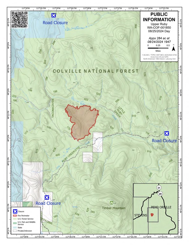
Upper Ruby Fire Daily Update 08 25 2024
Related Incident:
Publication Type: News
Upper Ruby Fire Daily Update
August 25, 2024
Quick Facts
Fire Perimeter: 284 acres
Initial Start: 08/20/24
Location: Ruby Creek Drainage - approximately 16 miles northwest of Cusick, WA
Hazards: Timber snags, bees, slippery footing, high winds and narrow roads
Values at Risk: Private residences, ongoing timber sales
Cause: Undetermined
Containment: 10%
Personnel: approximately 250
Structures destroyed: 0
Evacuations: None
Road Closures: Ruby Creek Road (5.5 miles in from Hwy 20), Tacoma Creek Rd (about 11 miles west of Hwy 20), and Tacoma Divide Road (about 4 miles
south of Hwy 20)
Ione, WA –
PUBLIC AND FIREFIGHTER SAFETY IS THE NUMBER ONE PRIORITY.
The Upper Ruby Fire is in central Pend Oreille County in the Ruby Creek Drainage approximately 16 miles northwest of Cusick, WA. It is burning in fuels remaining on the ground following logging activities and in heavily forested areas.
OPERATIONS: Yesterday, firefighters assessed the impact of the overnight storms and dealt with safety hazards. Then theyused heavy equipment and hand tools to build fire line. Firefighters were aided by aerial heat detection capabilities that identified the exact location of spot fires as small as a coffee cup. The remaining 0.5 mile section of unconnected fire line was completed and now control line surrounds the entire fire perimeter. Due to efforts in the past week, crews and equipment have achieved 10% containment. Although rain moderates fire behavior, the crews were safely pulled back from the fire area late in the day as this round of stormscreated slick conditions. Today, crews will widen lines to secure the fire perimeter and improve contingency lines. Applying water with fire hose and mopping up will continue to strengthen all the control lines.
HAZARDS: Hazards to firefighters include fire-weakened and standing dead trees (snags), fallen trees from recent wind gusts, slick footing and wet roads from recent rain, and a very high population of ground nesting bees.
WEATHER: Cool temperatures, light winds, and patchy morning fog forecast for Sunday morning. Warming temperatures and clearing skies expected through the day. Slight chance of rain showers is expected to move into the area Monday night through Tuesday before we see another round of possibly wet and windy weather.

August 25 2024 Whisky Creek and Sandstone Fires Daily Update 08 25 2024
Related Incident: Whisky Creek FireSandstone Fire
Publication Type: News
Whisky Creek Size: 2,067 acres | Reported Date: July 20 | Cause: Human, Under Investigation | Containment: 24%
Sandstone Size: 702 acres | Reported Date: August 5 | Cause: Lightning | Containment: 37%
Total Resources: 530 | Hand Crews: 9 | Engines: 10 | Dozers: 4 | Other Heavy Equipment: 19 | Helicopters: 4
(Odell, Ore.) -- Fire suppression efforts continue on the Whisky Creek Fire, 6 miles southeast of Cascade Locks, Ore. and the Sandstone and Blister Creek Fires, 9 miles southwest of Ripplebrook, Ore. The fires are burning in steep and rugged terrain on the Mt. Hood National Forest where rolling debris and fire-weakened trees challenge firefighting efforts. Firefighter and public safety remain the incident’s top priority. As fire managers work to contain these fires, strategic options about different types of fire lines, including containment, control and contingency lines, are continually being assessed. Line construction decisions are based on the terrain, weather, and available resources with the objective of maximizing the probability of success protecting key values while minimizing firefighter risk.
Whisky Creek: Yesterday, crews patrolling and monitoring the fire's eastern edge found little heat, indicating containment lines are holding well. To the southwest, crews extended the handline along the ridge from north of Wahtum Lake toward Tomlike Mountain. The process of mastication, aimed at reducing fuel, continued on Capron Springs Road from Forest Road 2820 and along Forest Road 2810 to support current primary lines and aid in future firefighting efforts. Today, firefighters will continue the handline along Tomlike Mountain ridge. On the eastern edge of the fire, monitoring and patrolling is ongoing.
Sandstone & Blister Creek: Yesterday, firefighters continued to monitor the control lines and uncontrolled edges of the Blister Creek Fire. Chipping operations on Forest Roads 7015 and 6320 processed vegetation and debris. Graders completed repairs on Forest Road 6322. Today, grading operations will shift to Forest Road 4620 toward Trout Creek to ensure better access for fire personnel. Containment on the Sandstone Fire increased to 37%.
Weather and Fire Behavior: Recent moisture will lead to low clouds and fog this morning, but partly to mostly sunny skies, warming temperatures and lowering humidity are forecast this afternoon. While recent rainfall has aided firefighting efforts, fire activity is likely to increase with the return of warming and drying conditions typical for this time of year.
Closures: The Mt. Hood National Forest, the Columbia River Gorge National Scenic Area and Hood River County closure information can be found by scanning the QR code or following the link below. Closures are in place for the safety of the public and fire crews.
Safety: The public plays an important role in preventing the next wildfire; use caution with all ignition sources. For prevention tips visit, https://keeporegongreen.org. Fire restrictions are in place within the Mt. Hood National Forest. More information can be found at: https://www.fs.usda.gov/main/mthood/fire. A Temporary Flight Restriction (TFR) is in place over both fire areas.
Smoke: Air quality conditions are forecast to be good for both fire areas. For more information on smoke conditions in your area, go to: www.AirNow.gov.
For further information about the Whisky Creek and Sandstone Fires, see the following resources:
Email: 2024.whiskycreek@firenet.gov or 2024.sandstone.or@firenet.gov
Phone: 541-208-1743, 8 a.m. – 8 p.m.
Web: Scan the QR code or go to https://linktr.ee/whisky_creek.2024
Big Hollow Fire Update 08 25 2024
Related Incident:
Publication Type: News
Location: 14 miles west of Grant, MT Start Date: August 23, 2024
Cause: Undetermined Size: 3450 acres Containment: 0%
CURRENT STATUS + PLANNED ACTIONS:
The Big Hollow Fire, located in the Big Hollow drainage 14 miles west of Grant, MT, is currently 3,450 acres. The fire is mainly burning through sage and grass on private and Bureau of Land Management land, although the northern edge has pushed into timbered land managed by the Forest Service. The entirety of the fire is being managed by the Montana Department of Natural Resources and Conservation.
Firefighting activities yesterday included establishing a dozer line along the north flank of the fire and conducting retardant drops along the northeast flank. The current Type 3 Incident Command structure continues to engage additional resources as they arrive. Today, crews will take advantage of lessened fire behavior to increase containment. Though containment sits at 0%, fire behavior overnight and into the morning has been low to moderate and most of the forward progression of the fire has been stopped. The percentage is expected to increase as crews continue to establish and secure containment lines, in preparation for any wind events that should occur.
The cause of the fire remains undetermined.
WEATHER AND FIRE BEHAVIOR:
Yesterday afternoon and into the evening saw active fire behavior, with spotting occurring along the northeast flank of the fire. Higher than predicted winds out of the west, with gusts up to 20-30 mph, made containment efforts difficult through the afternoon. The high winds resulted in the fire pushing eastward by 1 mile, although growth was checked within the Grime Creek drainage.
Today’s forecast shows a small chance of showers along with a high of 57 to 62 degrees Fahrenheit. Winds are predicted to range from 5-9 mph, beginning out of the northwest and shifting to the southeast in the afternoon.
EVACUATIONS AND CLOSURES
All evacuation orders have been lifted. The public has also been asked to remain clear of the area to avoid impeding firefighting activity. For updates on evacuations, visit the Inciweb page.
Park Fire Morning Update 08 25 2024
Related Incident: Park Fire
Publication Type: News
Park Fire Morning Update for August 25 is posted on the Park Fire Status Update Page
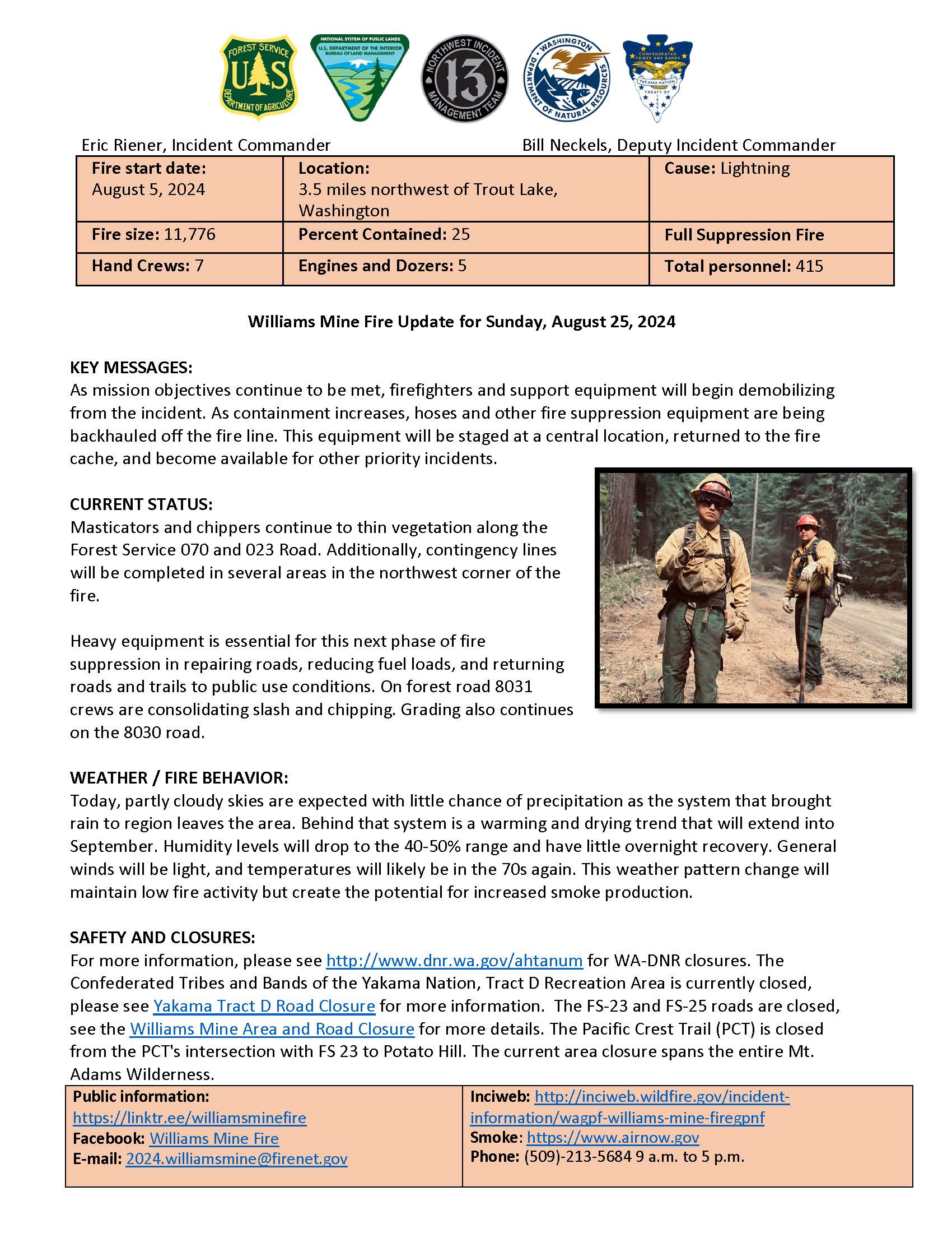
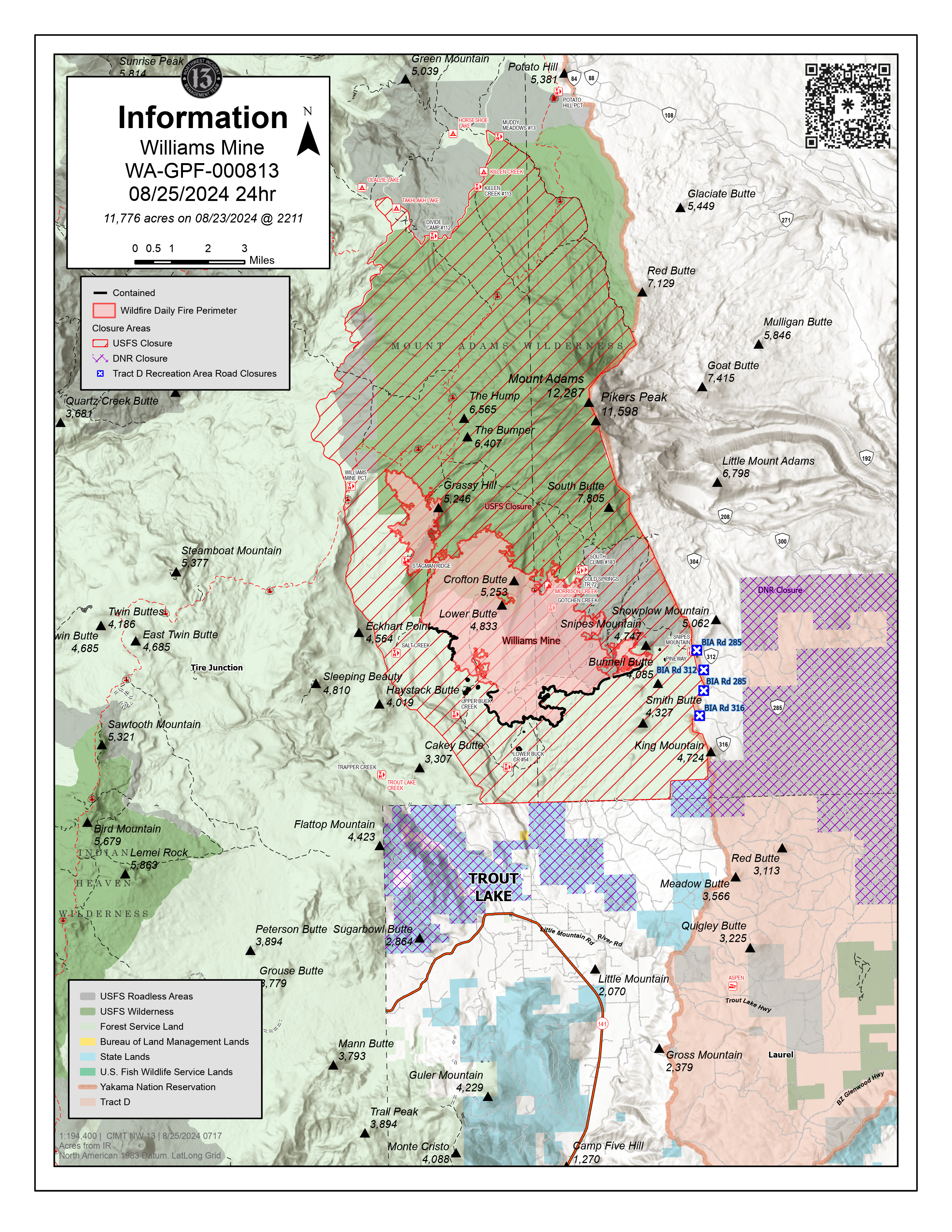
Williams Mine Fire Update 08 25 2024
Related Incident: Williams Mine Fire-GPNF
Publication Type: News
Williams Mine Fire Update for Sunday, August 25, 2024
KEY MESSAGES:
As mission objectives continue to be met, firefighters and support equipment will begin demobilizing from the incident. As containment increases, hoses and other fire suppression equipment are being backhauled off the fire line. This equipment will be staged at a central location, returned to the fire cache, and become available for other priority incidents.
CURRENT STATUS:
Masticators and chippers continue to thin vegetation along the Forest Service 070 and 023 Road. Additionally, contingency lines will be completed in several areas in the northwest corner of the fire.
Heavy equipment is essential for this next phase of fire suppression in repairing roads, reducing fuel loads, and returning roads and trails to public use conditions. On forest road 8031 crews are consolidating slash and chipping. Grading also continues on the 8030 road.
WEATHER / FIRE BEHAVIOR:
Today, partly cloudy skies are expected with little chance of precipitation as the system that brought rain to region leaves the area. Behind that system is a warming and drying trend that will extend into September. Humidity levels will drop to the 40-50% range and have little overnight recovery. General winds will be light, and temperatures will likely be in the 70s again. This weather pattern change will maintain low fire activity but create the potential for increased smoke production.
SAFETY AND CLOSURES:
For more information, please see http://www.dnr.wa.gov/ahtanum for WA-DNR closures. The Confederated Tribes and Bands of the Yakama Nation, Tract D Recreation Area is currently closed, please see Yakama Tract D Road Closure for more information. The FS-23 and FS-25 roads are closed, see the Williams Mine Area and Road Closure for more details. The Pacific Crest Trail (PCT) is closed from the PCT's intersection with FS 23 to Potato Hill. The current area closure spans the entire Mt. Adams Wilderness.