
Upper Ruby Fire Daily Update 08 27 2024
Related Incident:
Publication Type: News
Upper Ruby Fire Daily Update
August 27, 2024
Quick Facts
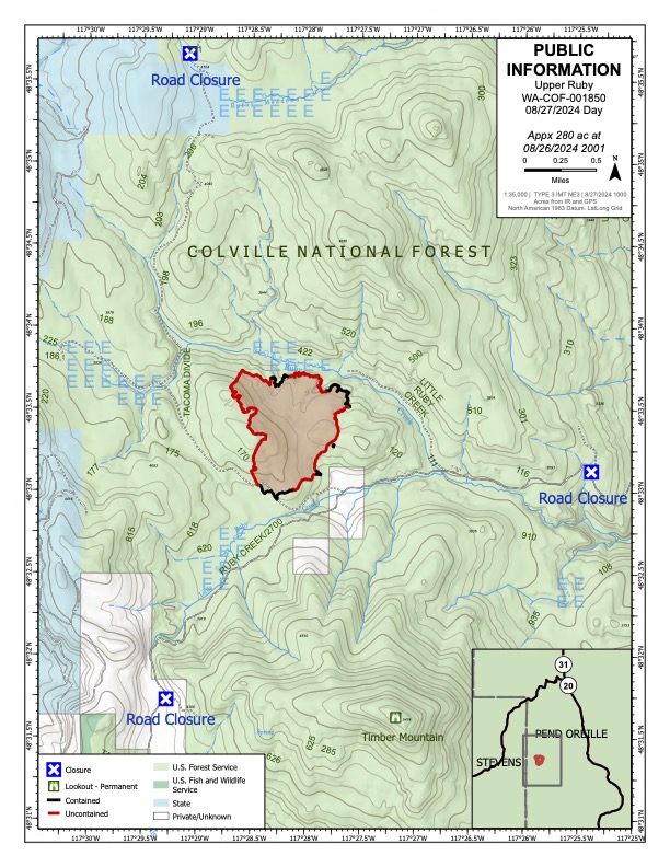
Containment: 31%
Fire Perimeter: 282 acres
Initial Start: 08/20/24
Location: Ruby Creek Drainage - approximately 16 miles northwest of Cusick, WA
Hazards: hot ash pits, timber snags, bees, and narrow roads
Values at Risk: Private residences, ongoing timber sales
Cause: Undetermined
Personnel: 228
Structures destroyed: 0
Evacuations: None
Road Closures: Ruby Creek Road (5.5 miles in from Hwy 20), Tacoma Creek Rd (about 11 miles west of Hwy 20), and Tacoma Divide Road (about 4 miles south of Hwy 20)
Ione, WA –
PUBLIC AND FIREFIGHTER SAFETY IS THE NUMBER ONE PRIORITY.
The Upper Ruby Fire is in central Pend Oreille County approximately 16 miles northwest of Cusick, WA. It is burning in fuels remaining on the ground following logging activities and in heavily forested areas.
OPERATIONS: Yesterday, 8 crews, 7 engines, 7 water tenders, and 10 pieces of heavy equipment continued mopping up along the fire perimeter to strength control lines. This included digging by hand, using hoses to apply water to the ground, and using heavy equipment. Crews mopped up at least 10 feet from the fire perimeter with some areas up to 66 feet. A contingency line on the northeast flank of the fire was completed. Containment was increased to 31%.
At least 8 medical personnel were staged throughout the fire to support fire personnel.
Today, crews will continue to mop up along the fire perimeter. Portable handheld infrared technology will be used to identify heat near the perimeter so that crews can work to extinguish those areas.
HAZARDS: Hazards to firefighters include hot ash pits, unstable footing, fire-weakened and standing dead trees (snags) and a very high population of ground nesting bees.
WEATHER: Gusty winds today may reach as high as 25 mph in the afternoon. There is a chance of rain showers in the morning with decreasing chance in the afternoon. Expect cold temperatures in the evenings tonight and tomorrow, but daytime temperatures could reach mid to upper 80s by this weekend.
Inciweb: https://inciweb.wildfire.gov/incident-information/wacof-upper-ruby
Facebook: https://www.facebook.com/newfireinfo
Phone: 509-990-6218 (hours 8 am – 8 pm)

Actualizacin del incendio Pioneer27 de agosto de 2024 08 27 2024
Related Incident:
Publication Type: News
Actualización del incendio Pioneer
27 de agosto de 2024
Size: 38,735 acres
Fecha de inicio: 8 de junio de 2024
Ubicación: 31 millas al NO de Chelan, WA
Contención: 23%
Personal: 418
Causa: A ser determinada
Recursos asignados: 8 equipos de obreros, 6 helicópteros, 8 camiones de bomberos, 15 tanques de agua, 8 maquinarias pesadas
SITUACIÓN ACTUAL: Los bomberos transportaron el equipo y las mangueras desde Moore Point hacia el sur a lo largo de la orilla del lago hasta el extremo sur del incendio. Las cuadrillas removieron manguera de las áreas de Safety Harbor y Coyote Ridge y las líneas de contingencia al sur del incendio. Los recursos en el área de Stehekin colocaron apilaron vegetación que se había removido. Continuaron monitoreando la intensidad del incendio en los desagues de Boulder Creek y Little Boulder Creek. Sigue en curso el trabajo de trituración y reparación de carreteras en el área de Cooper's Ridge al sur del incendio.
Ya está abierto Stehekin a los visitantes. Permanecen muchos peligros relacionados con incendios en el área y los servicios pueden ser limitados o alterados. Además, permanecen cerrados muchos senderos y campamentos debido a estos peligros. Los visitantes deben confirmar los servicios que están disponibles antes de viajar.
ACTIVIDADES DE HOY: Hoy los bomberos patrullarán y observarán la intensidad del fuego para asegurar que el fuego permanezca dentro de la huella existente. Las temperaturas más altas a finales de esta semana pudieran provocar un aumento del calor aislado y el humo que se ve dentro del perímetro del incendio. Aunque hoy se pronostica viento sobre el área del incendio, la vegetación ha retenido mucha humedad por las tormentas del fin de semana pasado y la dirección del viento pronosticado indica que las brasas reavivadas permanecerán dentro del perímetro del incendio. En el área de Little Boulder Creek, las cuadrillas comenzarán a reparar la línea de supresión para disminuir el riesgo de que se erosione el suelo. Las aeronaves apoyarán el trabajo en curso de remover equipo y proporcionarán patrullas aéreas del incendio. Los recursos al sur del incendio cerca de Manson están reparando la carretera por causa del tráfico de incendios. A medida que se minimiza la intensiad del fuego, el exceso de equipos y recursos se libera del incidente. Los bomberos permanecen listos para ayudar con cualquier posible fuego nuevo.
WEATHER: Breezy conditions are expected today with gusts up to 30 MPH on exposed ridges and along Lake Chelan. Winds will taper off throughout the day with a warming and drying trend starting Wednesday.
CLIMA: Hoy se esperan condiciones ventosas con ráfagas de hasta 30 mph en las crestas expuestas y a lo largo de Lake Chelan. Los vientos bajarán a través del día con una tendencia de calentamiento empezando el miércoles.
EVACUACIONES: Para ver los niveles de evacuación actuales, visite la página de Facebook del Departmanto de gestión de emergencias del condado de Chelan en facebook.com/CCSOEM o vea el https://chelangis.maps.arcgis.com/apps/instant/media/index.html?appid=ca1e19e4123b4002a9fb176b25434e03/.
CIERRES: Permanecen cerrados muchos senderos y campamentos. Consulta los cierres actuales para el Parque Nacional de las Cascadas del Norte en: https://www.nps.gov/noca/index.htm y el Bosque Nacional de Okanogan-Wenatchee: https://www.fs.usda.gov/alerts/okawen/alerts-notices. Las fogatas están prohibidas. El sendero Pacific Crest Trail está cerrado en áreas de Washington debido a varios incendios forestales. Para obtener más información, visite: closures.pcta.org/. Hay una Restricción Temporal de Vuelo (TFR, por sus siglas en inglés) sobre el incendio: tfr.faa.gov/save_pages/detail_4_2248.html. La actividad no autorizada con drones está prohibida por la TFR.
InciWeb: https://inciweb.wildfire.gov/incident-information/wases-pioneer
Facebook: https://www.facebook.com/profile.php?id=61560760893080
Línea de información sobre el incendio: 541-861-5808, de 8 AM a 8 PM
Email: 2024.pioneer@firenet.gov
Ratio Mountain Fire Update 08 27 2024
Related Incident: Ratio Mountain
Publication Type: News
Incident Commander: Mitch Robbins, Doug Bertelson (T)
Location: 15 miles north/northwest of Whitehall, MT
Start Date: 8/18/2024
Cause: Lightning
Size: 451 acres
Resources on Site: 3 crews
Total Personnel: 65
The Ratio Mountain Fire, located between Ratio Mountain and Whitetail Reservoir, is burning in an area that has recently experienced several large fires. Fire footprints (or previously burned areas) lie to the north (State Creek Fire of 2020), the south (McClusky Fire of 2019), and the west (Placer Fire of 2021) of the fire location.
The entire area, including the previous fire footprints and the area immediately surrounding the Ratio Mountain fire, contains a large concentration of standing dead trees (“snags”) that pose challenges to ensuring firefighter safety and in responding to potential medical emergencies, jeopardizing the well-being of firefighters and other responders.
Fire managers from the Forest, working in collaboration with local Jefferson County officials and cooperating agency representatives from the DNRC and BLM, have identified, mapped, and prioritized critical values at risk in the fire area. These inter-agency, values-based discussions are critical in fire management, informing the decision-making process.
CURRENT STATUS/PLANNED ACTIONS:
Strategic firing operations were successfully implemented on the eastern side of the fire, as firefighters used an Unmanned Aircraft System (“drone”) and hand ignitions to ignite and burn the fuels between the active fire edge and the constructed control lines from previous fire incidents along the Hay Canyon Road, working southerly along Pony Creek. The crews have progressed with completion of firing operations along this section, working to mop-up and secure the southern piece. Additional crews worked to prep existing lines to the north, in anticipation of tying into the State Creek Fire footprint.
Continuation of this firing operation to connect the current section, moving northeast, to the fire footprint from the State Creek Fire of 2020 will depend on fuel and weather conditions later this week. This fire suppression tactic is an effective method of reducing the available fuels ahead of an active fire edge, while reducing the potential for negative impacts to the identified and prioritized values.
WEATHER AND FIRE BEHAVIOR:
Fire behavior has been limited to isolated torching, creeping, and backing. A relatively dry cold front will bring an increase in west winds, with predicted gusts 25 to 35 mph. A RED FLAG WARNING is in effect for much of southwest Montana Tuesday afternoon and evening. These gusty winds, in combination with minimum relative humidity of 15 to 20 percent, result in critical fire weather. Much cooler temperatures are expected once the front passes. A hard morning freeze is possible Wednesday and Thursday.
CLOSURES AND RESTRICTIONS:
The Forest has issued an area closure around the fire area, north of Whitehall on the Butte Ranger District. An area closure often involves specific trail and road sections. The area closure information and maps can be found on the Forest website, under the Closures and Alerts tab. https://www.fs.usda.gov/alerts/bdnf/alerts-notices
This closure applies to the following National Forest System (NFS) lands, approximately 15 miles north of Whitehall.
All National Forest System lands within:
• T3N, R5W, SECTIONS 1, 2, 3
• T4N, R5W SECTION 35
Closures surrounding a fire area are necessary to protect the safety and welfare of the public and provide for safe firefighting efforts and access.
The Forest is in Stage 1 Fire Restrictions. Campfires are allowed only in a permanent metal fire grate/ring provided by the Forest Service in a designated, developed recreation site. Smoking is restricted to vehicles, in buildings, or in an area clear of flammable materials. Devices with an on/off switch that use LPG fuels are allowed in an area clear of flammable materials within 3 feet of the device.
Williams Mine Fire Update 08 27 2024
Related Incident: Williams Mine Fire-GPNF
Publication Type: News
Williams Mine Fire Update for Tuesday, August 27, 2024
KEY MESSAGES:
Complex Incident Management Team Northwest 13, which has been managing the Williams Mine Fire since August 9th, will transfer command of the incident tonight at 6:00 p.m. The fire will be managed by a local Type 3 Incident Management organization predominantly assembled from the local area.
The transition will not impact operations being carried out by firefighters and crews. Their focus will continue to be achieving incident objectives in a safe and efficient manner and ensuring that a smooth transition occurs.
CURRENT STATUS:
Crews continue patrolling and monitoring the southern and eastern portions of the fire to ensure containment lines remain secure. To the west, the mechanical prepping of FS-023 road continues and will remain a focus point for the Type 3 IMT organization and their operations. It is estimated that this operation will continue for at least another two weeks.
WEATHER / FIRE BEHAVIOR:
Weather will be slightly cooler today with humidity levels staying around 40 percent. Wind gusts may reach up to 30 mph today over the fire area. In the upcoming days, temperatures are expected to rise into the 80s. This warming trend has the potential for increased fire activity within the interior of the fire perimeter. This also may lead to increased smoke production which potentially will be visible from our local communities.
SAFETY AND CLOSURES:
The Confederated Tribes and Bands of the Yakama Nation, Tract D Recreation Area is currently closed, please see Yakama Tract D Road Closure for more information. The FS-023 and FS-25 roads are closed, see the Williams Mine Area and Road Closure for more details. The Pacific Crest Trail (PCT) is closed from the PCT's intersection with FS-023 to Potato Hill. The current area closure spans the entire Mt. Adams Wilderness.
Pincer Two Fire Daily Update 08 27 2024
Related Incident: Pincer Two Fire
Publication Type: Announcement
11:00 AM, August 27, 2024
Estimated size: 189 acres
Start Date/Time: July 17, 2024
Area of Origin: Johannesburg Mountain. 1 Mile East of Mineral Park C.G.
Cause: Lightning
Fuels/Topography: Timber, rugged terrain
Structures Damaged: None, there are no homes threatened at this time.
Evacuations: None
Closures: Cascade River Road at and including Marble Creek Campground, Mineral Park Campground, and all tributary roads, trailheads, and trails are all closed. The public is not to enter the area for public and firefighter safety.
Full closure orders available at: https://www.fs.usda.gov/mbs
Update: Rainfall last evening and overnight continued the trend of minimal fire activity on the Pincer Two. A Forest Service engine from Arizona has arrived and will begin patrolling and assisting with site rehabilitation of downed trees. A flight reconnaissance has been requested to ascertain the scope of the fire.
Weather: Showers are to linger today in the wake of a weak front. Can't rule out a slight chance (15%) of thunderstorms near the incident site also. An upper-ridge will build across the region starting tonight as warmer and drier conditions leads into the second half of the week. Weak offshore flow may also set up during this time along with unstable conditions. High temperature around 62 with cloudy skies becoming partly sunny.
Smoke: For more information on smoke and air quality please visit: https://wasmoke.blogspot.com/
Air Space Restrictions: There are no air space restrictions at this time.
Forest Restrictions: The Mt. Baker-Snoqualmie has a full campfire ban and forest-wide shooting restrictions in place to help prevent human-caused starts during this period of unprecedented resource scarcity. Additional details at: www.fs.usda.gov/mbs
###
Sharrott Creek Fire Daily Update 08 27 2024
Related Incident:
Publication Type: News
Video Update: https://fb.watch/udQ1w310SY/
Northern Rockies Team 3, Incident Commander Mike Behrens
Location: One mile west of Stevensville, Montana in Ravalli County
Start Date: 8/23/2024
Cause: Lightning
Size: 1,130 Acres
Completion/Containment: 0 percent
Resources assigned: 388 people
Key Messages
- Mike Behrens’ Northern Rockies Incident Management Team 3 took command of the fire at 0600 today.
- There will be a public meeting at Stevensville High School at 7 p.m. tonight.
Current Status
Air resources are dropping retardant and water to assist firefighters in checking the spread downhill on the eastern edge of the fire. Crews have established an anchor point on the southeast corner of the perimeter and are building direct and indirect line. Hotshot crews burned out along the east edge to bring the fire down to the 739A and B roads. They will hold and improve on that work today. Firefighters are also scouting locations for dozer line construction from the northeast corner of the fire towards Kootenai Creek. Fire managers are working on structure protection planning and firefighters are working on structure preparation in the neighborhoods near the eastern edge of the fire.
Night shifts are holding the eastern edge and patrolling the affected neighborhoods.
There is a temporary flight restriction (TFR) over the fire area west of Highway 93 from Bass Creek to Big Creek.
Weather and Fire Behavior
Temperatures are expected to reach the mid 70°s F with 20 percent relative humidity over the fire area. Winds will generally be from the southwest, switching to west-northwest with gusts to 35 mph on ridgetops. Increased fire behavior is expected with the passage of a cold front between 1 and 5 pm. Spotting up to a 1 mile is possible.
Smoke
For the current smoke reports, visit www.fire.airnow.gov/
EVACUATIONS, RESTRICTIONS, CLOSURES
The Ravalli County Sheriff’s Office has issued evacuation orders and warnings for neighborhoods in the vicinity of the Sharrott Creek Fire. For the latest status and an evacuation map, visit the Ravalli Co. Sheriff’s Office website: https://ravalli.us A Red Cross evacuation shelter is still available at the LDS Church in Stevensville at 100 Middle Burnt Fork Road. Evacuation questions can be directed to the Ravalli County Emergency Operations Center at 406-375-6650.
For the safety of firefighting pilots, do not fly unmanned aerial systems (drones) in the fire area.
27 de agosto de 2024 Actualizacin diaria de los incendios Whisky Creek y Sandstone 08 27 2024
Related Incident: Whisky Creek FireSandstone Fire
Publication Type: News
Tamaño de Whisky Creek: 2,075 acres | Fecha de inicio: 20 de julio | Causa: De orígen humano, a ser determinada | Contención 24%
Tamaño de Sandstone: 702 acres | Fecha de inicio: 5 de agosto | Causa: Rayo | Contención 58%
Total de recursos: 485 | Equipos de obreros: 8 | Camiones de bomberos: 9 | Topadoras: 2 | Otras maquinarias pesadas: 18 | Helicópteros: 4
(Odell, Oregón.) -- Sigue el trabajo de extinción en el incendio Whisky Creek, a 6 millas al sureste de Cascade Locks, Oregón, y en los incendios de Sandstone y Blister Creek, a 9 millas al suroeste de Ripplebrook, Oregón. Estos arden en un terreno escarpado y accidentado en el Bosque Nacional Mt. Hood, donde los escombros rodantes y los árboles debilitados por el fuego dificultan el trabajo de extinción. La seguridad de los bomberos y la del público siguen siendo la principal prioridad.
Una vez que las líneas de control se han establecido y la intensidad del fuego a lo largo de esos bordes ha disminuido, estas se convierten en líneas de contención. La contención indica que la propagación del fuego se ha detenido de manera efectiva en estos límites designados. Esto asegura que el incendio ya no es una amenaza para los valores críticos, tanto en las condiciones por el momento y las pronosticadas. La contención ha alcanzado el 58% en el incendio Sandstone y del 24% en el incendio Whisky Creek.
Whisky Creek: Ayer, las cuadrillas observaron el extremo oeste del incendio en el área de Herman Creek, sin no se vio actividad de fuego. Las cuadrillas de mano continuaron el trabajo en la línea de control en la cresta de la montaña Tomlike, mientras que en los extremos sureste, los bomberos vigilaron y patrullaron las líneas de contención. El trabajo de reparación y rehabilitación se centró en el extremo este del incendio, lo que significó una estrecha coordinación con los asesores de recursos para proteger los recursos culturales y naturales durante y después del incidente. En los próximos días, se comenzará a desmovilizar algunas maquinarias pesadas del incidente, ya que la mayor parte del trabajo de trituración a lo largo de las carreteras ya se ha completado. Hoy, las cuadrillas mejorarán y fortalecerán la línea de mano que se completó a lo largo de la cresta de la montaña Tomlike. Los bomberos patrullarán y monitorearán las líneas de contención a lo largo de los perímetros sur y este. Siguen en curso los trabajos de rehabilitación y reparación.
Sandstone & Blister Creek: Ayer, en el incendio Blister Creek, los bomberos entraron a la parte sur del incendio y solo vieron una intensidad mínima de fuego. Los pilotos de helicópteros ayudaron al personal de tierra vertiendo 6,400 galones de agua para enfriar el perímetro del incendio en el desague de Blister Creek. Los operadores de maquinarias pesadas alrededor del incendio Sandstone, se están enfocando en triturar y astillar mientras se sigue nivelando las carreteras. Hoy, las cuadrillas en el incendio Blister Creek continuarán monitoreando y aprovechándose del apoyo aéreo según lo permitan las condiciones.
Clima y intensidad del fuego: Un sistema débil se desplazó hacia la zona durante la noche, lo que resultó en lluvia por la mañana, mientras que esta tarde se esperan cielos soleados. El miércoles y el jueves podrían traer vientos más fuertes con ráfagas de hasta 15 a 20 mph en las cimas de las crestas. Para finales de la semana, se pronostican condiciones más tranquilas y temperaturas más altas.
Cierres: Información sobre el cierre del Bosque Nacional Mt. Hood y el Área Escénica Nacional del Río Columbia se puede encontrar en escaneando el código QR o siguiendo el enlace en la esquina inferior derecha de la página. Los cierres se implementarn para la seguridad del público y de los equipos de bomberos.
Seguridad: El público juega un papel importante en la prevención del próximo incendio forestal. Tenga cuidado con cualquier fuente de ignición. Para obtener consejos de prevención, visite, https://keeporegongreen.org. Hay restricciones contra incendios dentro del Bosque Nacional Mt. Hood. Se puede ver más información en https://www.fs.usda.gov/main/mthood/fire. Se ha establecido una restricción temporal de vuelo (TFR) en ambas áreas de incendio.
Humo: Se espera que la calidad del aire sea buena para ambas áreas de incendio. Para ver más información sobre las condiciones del humo en su área, visite: www.AirNow.gov.
Para más información sobre los incendios de Whisky Creek y Sandstone, consulte los siguientes recursos:
Correo electrónico: 2024.whiskycreek@firenet.gov or 2024.sandstone.or@firenet.gov
Teléfono: 541-208-1743, 8 a.m. – 8 p.m.
Sitio web: Escanea el código QR a la derecha o vaya a https://linktr.ee/whisky_creek.2024
Fish Creek Fire Update Tuesday 08 27 2024
Related Incident:
Publication Type: News
Northern Rockies Team 1, Incident Commander Brent Olson
Location: 7 miles SW of Togwotee Pass
Start Date: Friday, August 16, 2024
Cause: Lightning
Size: 11,278 acres
Percent complete: 26%
Resources: 364 Total Personnel; 2 dozers; 1 Masticator; 1 Feller Buncher; 5 Helicopters; 10 Hand Crews; 13 Engines; 2 skidsteers
Key Messages:
A recording of yesterday’s community meeting has been posted on the Bridger-Teton National Forest Facebook page. We will post a notification when the next community meeting is scheduled.
This incident is being managed under a confine/point protection strategy. Confine is a wildfire response strategy of restricting a wildfire to a defined area, primarily using natural barriers that are expected to restrict the spread of the wildfire under the prevailing and forecasted weather conditions. Point protection may include the installation of pumps, sprinkler systems, vegetative fuels reduction, and other measures to protect identified values-at-risk. The “percent complete” figure associated with an incident refers to the degree to which these actions have been accomplished.
Current Status:
Yesterday, firefighters began installing a hose line on the indirect line from Highway 26 south to Pilot Knob and towards the Moccasin Basin Trailhead. Crews worked on Deception Road along with some equipment to reduce vegetative fuels and construct an indirect fire control line. North of the fire, crews started preparing the Holmes Cave Trail as an indirect line by clearing vegetative fuels. Precipitation and cooler temperatures kept fire activity subdued and provided firefighters an opportunity to continue the preparation of indirect fire line north of the active fire area. Structure protection crews continued to conduct assessment work needs for creating defensible space around structures including the installation of pumps, hose, and sprinklers where needed.
Firefighters will continue indirect line construction today in locations north and northeast of the fire with the intent of protecting the values at risk. Some specific locations where this work will continue include Deception Road, the Holmes Cave Trail, and Spread Creek tying into Flagstaff Road. Structure protection efforts are continuing along the Highway 26 corridor.
Weather and Fire Behavior:
It will be warmer and drier today as high pressure moves back into the area. Expect mostly sunny skies with winds out of the southwest and humidity levels dropping to 25 percent. An approaching system out of Canada will return increased southwesterly wind on Wednesday. Gusts to 30 mph and humidity below 30 percent will lead to elevated fire weather conditions.
Today will be a good drying day after yesterday’s precipitation event. Pockets of dead and down fuel will continue to burn with smoldering and creeping fire behavior. Primarily low flame lengths and rates of spread are likely today in the timbered areas still holding heat. Tonight’s forecasted poor relative humidity recovery may allow for a longer burn period than what has been typically observed.
Air Quality and Smoke:
Air quality and smoke conditions and forecasts can be found at https://www.airnow.gov/.
Closures and Evacuations:
A joint Closure Order for the fire area has been issued by the Bridger-Teton and Shoshone National Forests for public and firefighter safety. Please do not enter the closure area or use the Forest Roads that are closed.
The Fish Creek Area, Roads, and Trails Closure Order (map) has been established for public and firefighter safety in the fire area. Full details can also be found at https://www.fs.usda.gov/alerts/btnf/alerts-notices.
Fremont County: Brooks Lake, Pinnacle Drive and Breccia Drive area remain in the Level 2 Evacuation notice. A Level 2 Evacuation means “Be Set” to evacuate. You must prepare to leave at a moment’s notice. This level indicates there is significant danger to your area, and residents should either voluntarily relocate to a shelter or with family/friends outside of the affected area, or if choosing to remain, to be ready to evacuate at a moment's notice. See the alert notice on the Fremont County Fire Protection District Facebook page.
Teton County: The Teton County Division of Emergency Management utilizes a Ready, Set, Go www.tetoncountywy.gov/1846/Ready-Set-GO system for evacuation messaging. All residents should be in the Ready status by preparing for evacuations and becoming fire adapted.
US HWY 26/287 continues to experience smoke and sometimes limited visibility. Wyoming Department of Transportation (WYDOT) is working closely with Fremont County Emergency Management and fire officials for the safety of motorists and firefighters. Drivers are encouraged to visit https://www.wyoroad.info/ prior to traveling on US HWY 26/287 for road status and information, or download the Wyoming 511 app at https://www.wyoroad.info/511/WY511Mobile.html to monitor for any changes due to fire activity.
Miners Complex Daily Update 08 27 2024
Related Incident: Miners Complex Fires
Publication Type: Announcement
11:00 AM, August 27, 2024
Estimated size: 1,098 acres
Start Date/Time: July 17, 2024
Area of Origin: 21 air miles east of Darrington WA
Cause: Lightning
Fuels/Topography: timber, rugged terrain
Structures Damaged: None, there are no homes threatened at this time.
Evacuations: None
The Miners Complex consists of eight wildfires caused by lightning strikes in the Mt. Baker-Snoqualmie National Forest. The fires included in the complex are Miners Fire, Vista Ridge Fire, Dolly Creek Fire, Sulphur Three Fire, Sulphur Four Fire, Sulphur Thirty-Four Fire, Plummer, and Middle Ridge Fire.
Update: Rainfall last evening and overnight continued the trend of minimal fire activity on the Miners Complex fires. A Forest Service engine from Arizona has arrived and will begin patrolling the fires. A flight reconnaissance has been requested to ascertain the scope of the fire.
Weather: Showers are to linger today in the wake of a weak front. Can't rule out a slight chance (15%) of thunderstorms near the incident site also. An upper-ridge will build across the region starting tonight as warmer and drier conditions leads into the second half of the week. Weak offshore flow may also set up during this time along with unstable conditions. High temperature around 62 with cloudy skies becoming partly sunny.
Smoke: For more information on smoke and air quality please visit: https://wasmoke.blogspot.com/
Closures: The following is a summary of the areas closed due to the fires in the Miners Complex: Pacific Crest National Scenic Trail #2000.2 from Mica Lake to Suiattle Pass, Suiattle River Trail #784, Miners Ridge Trail #785, Buck Creek Pass Trail #789, Miners Cabin Trail #795, Grassy Point Trail #788, Sulphur Mountain Trail #794, Sulphur Creek Trail #793, Sulphur Creek Campground, Sulphur Creek Trailhead, and the Downey Creek trailhead. Suiattle River Road, closure beginning at Downey Creek trailhead. The full Closure Orders visit: https://www.fs.usda.gov/mbs Forest Restrictions: The Mt. Baker-Snoqualmie has a full campfire ban and forest-wide shooting restrictions in place to help prevent human-caused starts during this period of unprecedented resource scarcity. Additional details at: www.fs.usda.gov/mbs
###
August 27 2024 Whisky Creek and Sandstone Fires Daily Update 08 27 2024
Related Incident: Whisky Creek FireSandstone Fire
Publication Type: News
Whisky Creek Size: 2,075 acres | Reported Date: July 20 | Cause: Human, Under Investigation | Containment: 24%
Sandstone Size: 702 acres | Reported Date: August 5 | Cause: Lightning | Containment: 58%
Total Resources: 485 | Hand Crews: 8 | Engines: 9 | Dozers: 2 | Other Heavy Equipment: 18 | Helicopters: 4
(Odell, Ore.) -- Fire suppression efforts continue on the Whisky Creek Fire, 6 miles southeast of Cascade Locks, Ore. and the Sandstone and Blister Creek Fires, 9 miles southwest of Ripplebrook, Ore. The fires are burning in steep and rugged terrain on the Mt. Hood National Forest where rolling debris and fire-weakened trees challenge firefighting efforts. Firefighter and public safety remain the incident’s top priority.
After control lines have been established and fire activity along those edges has diminished, these features become containment lines. Containment indicates that the fire’s spread has been effectively stopped at these designated boundaries. This ensures that the fire no longer poses a threat to critical values, under current as well as forecast conditions. Containment has now reached 58% at the Sandstone Fire and is 24% at the Whisky Creek Fire.
Whisky Creek: Yesterday, crews monitored the west side of the fire in the Herman Creek area, observing no fire activity. Hand crews continued work on the Tomlike Mountain ridge control line, while on the southeast edges, firefighters monitored and patrolled containment lines. Repair and rehabilitation efforts focused on the eastern edge of the fire, involving close coordination with Resource Advisors to protect cultural and natural resources during and after the incident. In the coming days, some heavy equipment will begin to demobilize from the incident, as most mastication efforts along roadways are now complete. Today, crews will improve and strengthen the completed handline along Tomlike Mountain ridge. Firefighters will patrol and monitor containment lines along the south and east perimeters. Rehabilitation and repair work is ongoing.
Sandstone & Blister Creek: Yesterday, on the Blister Creek Fire, firefighters accessed the southern, uncontained portion of the fire and found minimal fire activity. Helicopter pilots assisted the ground crew by dropping 6,400 gallons of water to cool the smoldering fire perimeter in the Blister Creek drainage. Around the Sandstone Fire, heavy equipment operators are focusing on masticating and chipping while road grading continues. Today, crews on the Blister Creek Fire will continue to monitor and utilize aerial support as conditions allow.
Weather and Fire Behavior: A weak system moved into the area overnight, bringing trace amounts of precipitation in the morning, while sunny skies are expected this afternoon. Wednesday and Thursday could bring increased winds with gusts up to 15 to 20 mph on ridgetops. Calmer conditions and rising temperatures are forecast for later this week.
Closures: The Mt. Hood National Forest, the Columbia River Gorge National Scenic Area and Hood River County closure information can be found by scanning the QR code or following the link below. Closures are in place for the safety of the public and fire crews.
Safety: The public plays an important role in preventing the next wildfire; use caution with all ignition sources. For prevention tips visit, https://keeporegongreen.org. Fire restrictions are in place within the Mt. Hood National Forest. More information can be found at: https://www.fs.usda.gov/main/mthood/fire. A Temporary Flight Restriction (TFR) is in place over both fire areas.
Smoke: Air quality conditions are forecast to be good for both fire areas. For more information on smoke conditions in your area, go to: www.AirNow.gov.
For further information about the Whisky Creek and Sandstone Fires, see the following resources:
Email: 2024.whiskycreek@firenet.gov or 2024.sandstone.or@firenet.gov
Phone: 541-208-1743, 8 a.m. – 8 p.m.
Web: Scan the QR code or go to https://linktr.ee/whisky_creek.2024