
Williams Mine Fire Area and Road Closure Revised 08 28 2024
Related Incident: Williams Mine Fire-GPNF
Publication Type: Closures
ORDER NO. 06-03-03-24-03
GIFFORD PINCHOT NATIONAL FOREST
Mount Adams Ranger District
Trout Lake, Washington
WILLIAMS MINE AREA AND ROAD CLOSURE
This closure order supersedes Closure Order 06-03-03-24-02.
Pursuant to 16 U.S.C. § 551 and 36 CFR 261.50 (a) and (b), the following acts are prohibited on the area described in this order and depicted on Exhibit A, within and/or administered by the Gifford Pinchot National Forest, Mount Adams Ranger District, until further notice:
1. Going into or being upon the area affected by the Williams Mine Fire (36 CFR 261.52(e))
2. Being on a road. [36 CFR § 261.54(e)].
PURPOSE:
The purpose of this order is to protect public health and safety due to the Williams Mine fire, as well as to allow for safe and efficient firefighting operations.
AREA CLOSURE:
The following description serves as the exterior boundary and closes all lands encompassed within it as depicted in attached Exhibit A:
From a point of beginning on National Forest System (NFS) Road 2300 (posted 23), approximately 3 miles north of Trout Lake, in the southeast corner of Section 33, T7N, R10E; then approximately 17 miles north to the junction of NFS Road 2300 and NFS Road 2329 in the northwest corner of Section 17 T9N, R10E; then east-north-east on NFS Road 2329 approximately 7 miles to the junction of NFS Road 2329 and NFS Road 5603 in the northwest corner of Section 23, T10N, R10E; then east on NFS 5603 approximately 2 miles to the eastern boundary of the Gifford Pinchot National Forest (GPNF) in the northwest corner of Section 30, T10N, R11E; then south along the GPNF eastern boundary approximately 20 miles to Section 33, T7N, R11E; then west along the southern GPNF boundary to NFS Road 2300, to the point of beginning, in the southeast corner of Section 33, T7N, R10E.
The following road surfaces along the Area Closure are open to public traffic, but only to the extent of the graded or surfaced area of the roadway
• NFS Road 2300 north from its junction with NFS Road 90 in the southeast corner of Section 25, T9N, R9E.
• NFS Road 2329 from its junction with NFS Road 23 in the northwest corner of Section 17 T9N, R10E; then east-north-east on NFS Road 2329 approximately 7 miles to the junction of NFS Road 2329 and NFS Road 5603 in the northwest corner of Section 23, T10N, R10E.
• NFS Road 5603 from its junction with NFS Road 2329 in the northwest corner of Section 23, T10N, R10E to the eastern boundary of the GPNF in the northwest corner of Section 30, T10N, R11E.
ROAD CLOSURE:
Travel is prohibited on the following National Forest System (NFS) Roads as described below and shown on the attached map (Exhibit A).
• NFS Road 2300 from its origin at the southern boundary of the Gifford Pinchot National Forest in the southeast corner of Section 33, T7N, R10E to its junction with NFS Road 90 in the southeast corner of Section 25, T9N, R9E.
EXEMPTIONS:
1. Any Federal, State, or County officer, or member of an organized rescue or firefighting force in the performance of an official duty.
2. Persons with Forest Service Permit No. FS-7700-48 (Permit for Use of Roads, Trails, or Areas Restricted by Regulation Order), specifically exempting them from this order.
3. Persons traveling for evacuation purposes.
These prohibitions are in addition to the general prohibitions in 36 CFR Part 261, Subpart A.
Violation of these prohibitions is punishable by a fine of not more than $5,000 for an individual or $10,000 for an organization, or imprisonment for not more than 6 months, or both (16 U.S.C. § 551; 18 U.S.C. §§ 3551, 3559, 3571, and 3581).
Executed in Vancouver, Washington, this 28th day of August 2024.
Johanna Kovarik
Forest Supervisor
Gifford Pinchot National Forest
Wapiti Fire Community Q and A 08 29 2024
Related Incident:
Publication Type: Announcement
We will have Public Information Officers (PIOs) and information boards throughout the communities tomorrow to get in-person updates. PIOs on the Lowman side will be at the Sourdough Lodge located at 8406 ID-21 Lowman, Idaho for their Pop-up tomorrow August 29 from 4-6pm. Come down to see us!
Pioneer Fire Potential for Visible Smoke as Temperatures Warm 08 28 2024
Related Incident:
Publication Type: News
Warming temperatures this week may lead to increased isolated heat and smoke visible within the perimeter of the Pioneer Fire as large logs and stumps continue to smolder.
Moisture from recent rainfall has decreased large vegetation’s receptiveness to fire; however, this may change as hot conditions persist.
Firefighters will patrol and monitor fire activity from the ground and air, including the use of infrared unmanned aerial systems (UAS) to detect heat, and ensure the Pioneer Fire stays within the existing footprint.
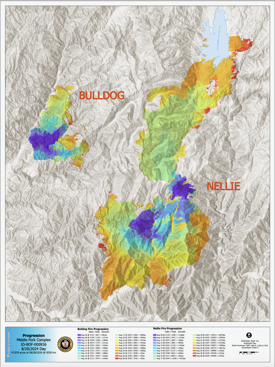
Wildland Fire Progression Maps What are they and how to read them 08 28 2024
Related Incident:
Publication Type: News
Maps are invaluable tools that guide us and tell fascinating stories. When it comes to wildland fires, Geographic Information Specialists (GIS) create a series of maps each day to assist Incident Management Teams and inform the community. These maps cover various aspects, including road closures, landscape topography, and ongoing firefighting efforts.
One very informative GIS product is called the Progression Map. This map visually represents how a wildfire has progressed, showing how much acreage was added each day. GIS technicians show each day's growth in a different color and provide a legend listing the amount of acreage affected. For example, on August 14th, the Bulldog Fire grew by 388 acres, while the Nellie Fire increased by 523 acres (see the map here).
By examining a Progression Map, you can gain valuable insights into daily fire activity and track trends over time. We hope this helps you better understand and interpret these important maps.
What does containment mean and how is it measured 08 28 2024
Related Incident:
Publication Type: News
Containment on the Pioneer Fire
Many have asked why the percentage of containment on the Pioneer Fire has not increased despite there being limited to no growth of the fire recently.
What does containment mean and how is it measured?
“Containment” indicates how much of the fire perimeter has been surrounded by a control line that the fire will not progress across. Rather than describing how much of the entire fire has been put out, containment refers solely to the perimeter itself and its potential for growth. Containment is normally expressed as a percentage of the entire perimeter. Fire managers will not label a portion of the fireline “contained” until they are confident that the fire will not grow further in that direction.
The Pioneer Fire has not grown in recent days so why is containment not changing?
There are several places in the fire area where very steep, inaccessible terrain has limited the ability for firefighters to construct containment line on the ground. In many of these places, natural features such as rocks and previous fire scars are holding the fire in place. However, firefighters will only change the status of an area to “contained” when there is no heat on the perimeter and no chance for it to grow in that area.
What has been accomplished?
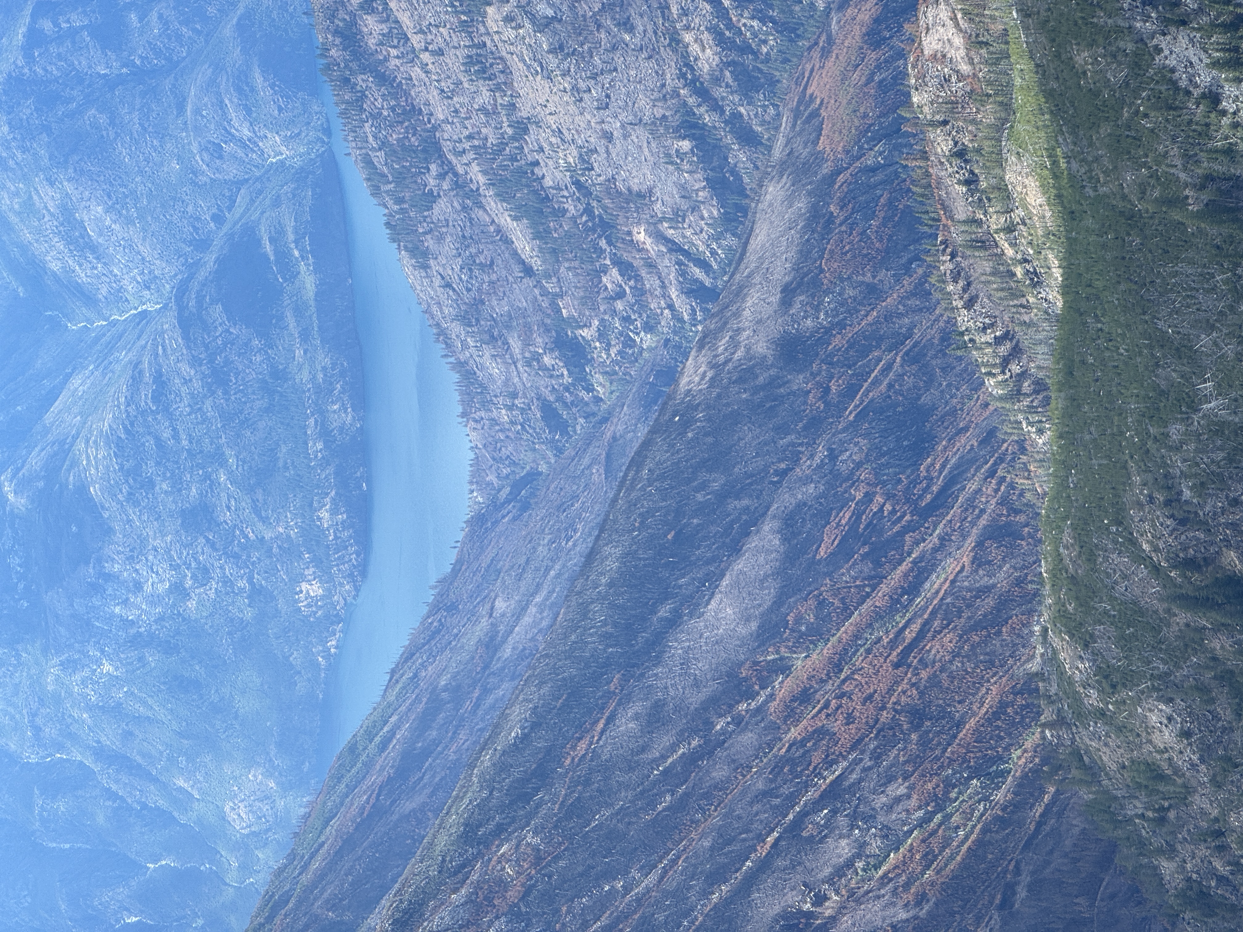
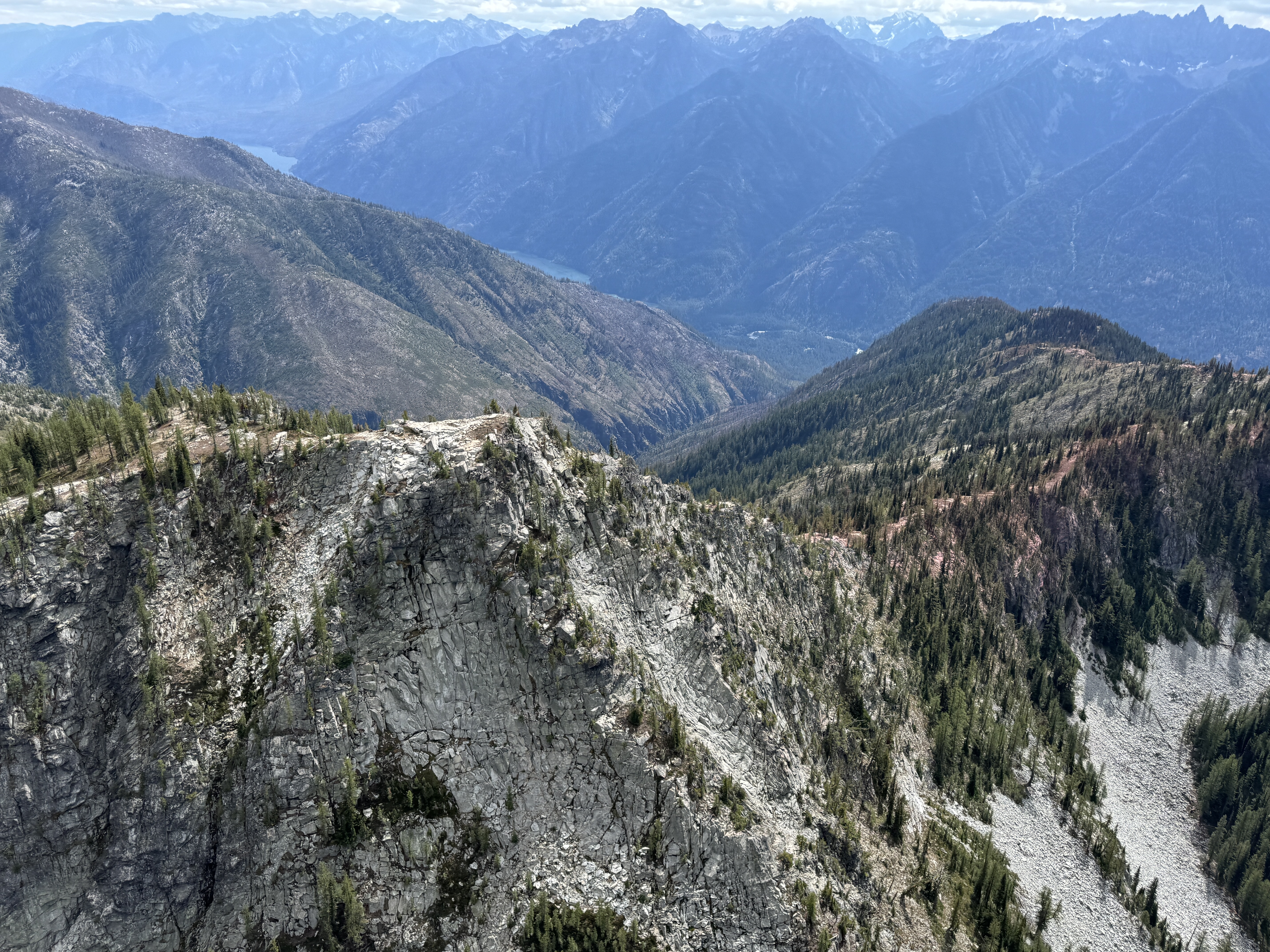
Firefighters have worked to prepare check lines and containment lines, where possible, and in combination with strategically placed water and retardant drops, they have been successful protecting private residences and other infrastructure along the lakeshore and within the Stehekin area. These efforts allowed time for firefighters to put structure protection measures in place throughout the community.
South of the fire crews prepared indirect contingency lines along several key ridges to prevent fire spread towards Manson and completed a shaded fuel break along Cooper Ridge that could be used to slow fire growth and prevent spread towards the Methow Valley.
McElwain Fire Update 08 28 2024
Related Incident:
Publication Type: Announcement
Location: 10 miles west of Helmville, Montana
Start Date: 8/23/2024
Cause: Lightning
Size: 176 acres
Containment: 5%
CURRENT STATUS
The McElwain Fire, located 10 miles west of Helmville in Powell County, remains at 176 acres in size. Though full assessment by crews will occur today, the fire appears to have stayed within its footprint even with the strong winds that hit the fire yesterday evening. Moisture was received yesterday as well, which helped to moderate fire activity. Control line has been completed around both the south and north fires and firefighters are working to secure the line, extinguishing all heat and flame 100 feet deep. The fire is 5% contained with the anticipation that this will increase later today as line is fully secured.
The fire is burning in grass and timber on private and Bureau of Land Management land under Montana DNRC wildland fire protection. It is comprised of two adjacent fires, a north fire, and a south fire and fire behavior includes creeping and smoldering with isolated torching. Resources include four engines, two Type 2 hand crews, one eight-person hand crew (Module), one water tender, four skidgines, and one dozer. A Type 2 DNRC helicopter will support as needed.
WEATHER
Cooler temperatures and elevated winds continue today, with high pressure redeveloping later this week. Above normal temperatures and minimum relative humidities in the teens and lower 20s are predicted.
EVACUATIONS AND CLOSURES
The Powell County Sheriff’s Office has lifted all evacuation warnings in the area, including residents in the Ledger Road area. Please visit the Powell County Sheriff’s Office Facebook page for specific information and further updates. Please use caution if travel is necessary in the area due to increased firefighting traffic.
ADDITIONAL AREA FIRES
The Hoodoo Fire, a six-acre lightning caused fire on Hoodoo Mountain seven miles southeast of Helmville is contained and controlled at this time and will be periodically patrolled. The Hoodoo Fire is on BLM land under DNRC wildland fire protection.
Powell County is currently in Stage 1 fire restrictions. Residents and visitors are asked to be extra careful when outdoors to limit human caused sparks. We cannot control the lightning, but we can prevent unintended human caused wildfires. Visit www.MTFireInfo.org for specific fire restriction information and fire prevention tips.
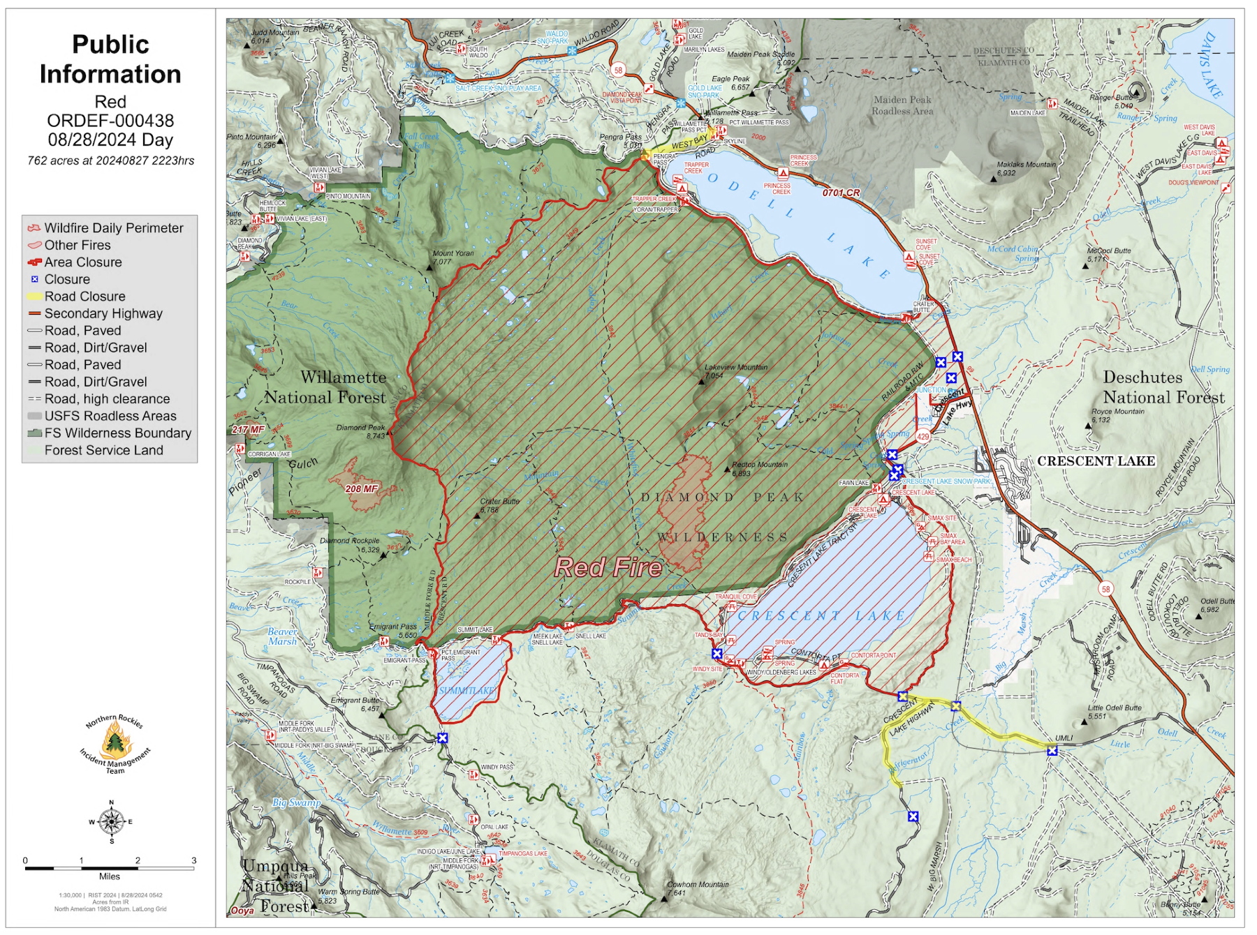
August 28 2024 Red Fire Daily Update 08 28 2024
Related Incident: Red Fire
Publication Type: News
Size: 755 acres Location: 5 miles west of Crescent Lake Junction, OR County: Klamath
Start Date: July 17, 2024 Cause: Lightning Containment: 0% Total Personnel: 167
Activities – Crews have completed work on the shaded fuel break along the northwest of Crescent
Lake and are focusing their efforts on the section between Crescent Lake and Summit Lake. Fire
personnel have widened the shaded fuel break buffer adjacent to Forest Service Road (FSR) 6010
and removed all debris within a 200-foot width and left widely spaced mature trees approximately 25
to 75 feet apart. If fire reaches the shaded fuel break, it will be slowed because there is less fuel
available to burn. Shaded fuel breaks favorably slow fire spread and have long-term fire protection
benefits.
Incident Strategy – A full suppression strategy is being implemented utilizing shaded fuel breaks.
Fire managers are continually reevaluating the safest, most effective suppression strategy based on
changing weather, fuel conditions, and fire behavior. Firefighter and public safety remain the
management team’s highest priority in managing this fire.
Closures – To provide for the safety of our staff, equipment operators, and public the Deschutes
National Forest emergency closure around Crescent Lake and in Diamond Peak Wilderness is still in
effect, include these areas: Forest Service Road 60 is closed, and road guards have been posted for
public safety. More closure information is available at: https://www.fsa.gov/alerts/deschutes/alertsnotices/?
aid=89091
Weather and Smoke – Much warmer and drier conditions were experienced again across the fire on
Tuesday under mostly clear skies. Yesterday, highs were in the mid to upper 60s with minimum
relative humidity around 37 to 43 percent. East winds of 4 to 8 mph with gusts up to 15 mph are
expected on the fire today.
Evacuations – The WILDFIRE! Level 1 – BE READY to Evacuate notice issued by Klamath County
Emergency Management for Crescent Lake, Odell Lake, and Crescent Junction areas remains in
effect (INCENDIO FORESTAL! Nivel 1 - ESTÉ PREPARADO para evacuar de las siguientes zonas:
Crescent Lake, Odell Lake, Crescent Junction). Visit www.klamathcounty.org/300/emergencymanagement
for more information or to sign up for alerts.
Fire Restrictions – Stage 2 Public Use Fire Restrictions – which prohibit open fires, including in
developed campgrounds – remain in effect for the Deschutes National Forest. The Industrial Fire
Precaution Level is currently Level III “Partial Shutdown.” Visit
fs.usda.gov/detail/deschutes/home/?cid=stelprdb5297376 for more information.
Drone Restrictions – Aerial firefighting is suspended when unauthorized drones (UAS) are in the
area. Unauthorized drone use over a fire area poses serious risks to fire personnel and the
effectiveness of wildfire suppression operations. If you fly, we can’t.
Actualizacin del incendio Pioneer28 de agosto de 2024 08 28 2024
Related Incident:
Publication Type: News
Actualización del incendio Pioneer
28 de agosto de 2024
Tamaño: 38,735 acres
Fecha de inicio: 8 de junio de 2024
Ubicación: 31 millas al NO de Chelan, WA
Contención: 23%
Personal: 401
Causa: A ser determinada
Recursos asignados: 4 equipos de obreros, 6 helicópteros, 5 camiones de bomberos, 13 tanques de agua, 7 maquinarias pesadas
Esta será la última actualización diaria para el incendio Pioneer a menos que se vea un cambio en la actividad o las condiciones del fuego.
SITUACIÓN ACTUAL: Los bomberos han tenido éxito en proteger residencias privadas y otras infraestructuras al lado del lago y dentro del área de Stehekin y en las últimas dos semanas ha habido poco o ningún crecimiento y una actividad mínima de fuego. Ayer, los bomberos completaron de transportar el exceso de equipo a lo largo de la orilla del lago y las líneas de contingencia al sur del incendio. Los equipos de bomberos también continuaron reparando el cortafuegos en el área de Little Boulder Creek. Los bomberos que monitoreaban el borde del incendio vieron un poco de humo de los troncos humeantes en el desague de Boulder Creek, en el interior del incendio. Debido a las condiciones de clima más cálidas y secas que se pronostican para la semana, es probable que haya humo adicional a medida que los combustibles grandes, como los troncos caídos, se queman lentamente. Ayer no hubo operaciones de aeronaves debido a los fuertes vientos sobre la zona del incendio.
ACTIVIDADES DE HOY: Los bomberos continuarán patrullando los cortafuegos cerca de Stehekin y buscarán cualquier foco de calor que pueda amenazar las líneas de contención. Continuarán las actividades de reparación por causa de la extinción, y trabajarán para completar de apilar la maleza que queda y reparar las carreteras dañadas por el tráfico relacionado con el fuego. Las aeronaves apoyarán las operaciones con vuelos de reconocimiento para ver la actividad de incendios y los helicópteros transportarán el exceso de equipos desde sitios aislados. Los bomberos están preparados para el ataque inicial de nuevos fuegos.
Hoy es el último día del Puesto de comando de incidentes en Manson. A las 5:00 p.m. hoy, la gestión del incendio Pioneer desde Safety Harbor hacia el norte se transferirá a una organización más pequeña de gestión de incidentes Tipo 3 con sede en Stehekin. La gestión del incendio Pioneer desde Safety Harbor hacia el sur se transferirá de nuevo al Bosque Nacional Okanogan-Wenatchee a las 5:00 p.m. hoy.
CLIMA: Hoy llegarán condiciones más calientes y secas y persistirán el fin de semana. Mañana las temperaturas estarán en los 70 grados hoy y a mediados de los 80. La velocidad del viento se ha moderado desde ayer, y se prevén vientos principalmente impulsados por el terreno para el área del incendio.
EVACUACIONES: Para ver los niveles de evacuación actuales, visite la página de Facebook del Departmanto de gestión de emergencias del condado de Chelan en facebook.com/CCSOEM o vea el https://chelangis.maps.arcgis.com/apps/instant/media/index.html?appid=ca1e19e4123b4002a9fb176b25434e03/.
CIERRES: Permanecen cerrados muchos senderos y campamentos. Consulta los cierres actuales para el Parque Nacional de las Cascadas del Norte en: https://www.nps.gov/noca/index.htm y el Bosque Nacional de Okanogan-Wenatchee: https://www.fs.usda.gov/alerts/okawen/alerts-notices. Las fogatas están prohibidas. El sendero Pacific Crest Trail está cerrado en áreas de Washington debido a varios incendios forestales. Para obtener más información, visite: closures.pcta.org/. Hay una Restricción Temporal de Vuelo (TFR, por sus siglas en inglés) sobre el incendio: tfr.faa.gov/save_pages/detail_4_2248.html. La actividad no autorizada con drones está prohibida por la TFR.
InciWeb: https://inciweb.wildfire.gov/incident-information/wases-pioneer
Facebook: https://www.facebook.com/profile.php?id=61560760893080
Línea de información sobre el incendio: 541-861-5808, de 8 AM a 8 PM
Email: 2024.pioneer@firenet.gov
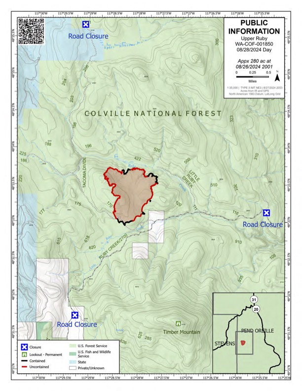
Upper Ruby Fire Daily Update 08 28 2024
Related Incident:
Publication Type: News
Upper Ruby Fire Daily Update
August 28, 2024
Quick Facts
Containment: 39%
Fire Perimeter: 280 acres
Initial Start: 08/20/24
Location: Ruby Creek Drainage - approximately 16 miles northwest of Cusick, WA
Hazards: hot ash pits, timber snags, bees, and narrow roads
Values at Risk: Private residences, ongoing timber sales
Cause: Undetermined
Personnel: 262
Structures destroyed: 0 Evacuations: None
Road Closures: Ruby Creek Road (5.5 miles in from Hwy 20), Tacoma Creek Rd (about 11 miles west of Hwy 20), and Tacoma Divide Road (about 4 miles south of Hwy 20)
Ione, WA
PUBLIC AND FIREFIGHTER SAFETY IS THE NUMBER ONE PRIORITY.
The Upper Ruby Fire is in central Pend Oreille County approximately 16 miles northwest of Cusick, WA. It isburning in fuels remaining on the ground following logging activities and in heavily forested areas.
OPERATIONS: Yesterday, 10 crews, 9 engines, 7 water tenders, and 3 pieces of heavy equipment continued mopping up along the fire perimeter to strengthen control lines. This included digging by hand, using hoses to apply water to the ground, and using heavy equipment. Portable handheld infrared technology was used to identify heat near the fire perimeter. Crews mopped up at least 33 feet from the fire perimeter with some areas up to 100 feet. Containment was increased to 39%.
At least 8 medical personnel were staged throughout the fire to support fire personnel.
TODAY: crews will continue to mop up along the fire perimeter. Portable handheld infrared technology will continue to be used to identify heat near the fire perimeter so that crews can work to extinguish those areas.
HAZARDS: Hazards to firefighters include hot ash pits, unstable footing, fire-weakened and standing dead trees (snags) and a very high population of ground nesting bees.
WEATHER: Partly cloudy in the morning becoming mostly sunny in the afternoon. High temperature around 63 degrees. Westerly winds 4 to 6 mph with gusts to 14 mph in the afternoon.
Inciweb: https://inciweb.wildfire.gov/incident-information/wacof-upper-ruby
Facebook: https://www.facebook.com/newfireinfo
Phone: 509-990-6218 (hours 8 am – 8 pm)

WYDOT Expects Short Delays on Hwy 26 08 28 2024
Related Incident:
Publication Type: Announcement
WYDOT UPDATE:
The Wyoming Department of Transportation will be conducting traffic control on U.S. Highway 26/287 today while fire crews preemptively cut down hazardous trees along the highway at several locations between mile posts 27 and 31. Motorists should expect intermittent delays during this tree-removal work. If these trees were to catch fire, embers from them could blow across the highway possibly allowing the fire to continue to move north. As these trees burn they could fall onto the highway unexpectedly, creating a dangerous situation for the firefighters and public that might be travelling on the highway.
See our Facebook Page: https://www.facebook.com/ExcellenceInTransportation/