
Ratio Mountain Fire Update 08 29 2024
Related Incident: Ratio Mountain
Publication Type: News
Incident Commander: Matt Racicot, Noah Criner (T)
Location: 15 miles north/northwest of Whitehall, MT
Start Date: 8/18/2024
Cause: Lightning
Size: 451 acres
Resources on Site: 4 crews; 1 engine
Total Personnel: 90
The Ratio Mountain Fire, located between Ratio Mountain and Whitetail Reservoir, is burning in an area that has recently experienced several large fires. Fire footprints (or previously burned areas) lie to the north (State Creek Fire of 2020), the south (McClusky Fire of 2019), and the west (Placer Fire of 2021) of the fire location.
The entire area, including the previous fire footprints and the area immediately surrounding the Ratio Mountain fire, contains a large concentration of standing dead trees (“snags”) that pose challenges to ensuring firefighter safety and in responding to potential medical emergencies, jeopardizing the well-being of firefighters and other responders.
Fire managers from the Forest, working in collaboration with local Jefferson County officials and cooperating agency representatives from the DNRC and BLM, have identified, mapped, and prioritized critical values at risk in the fire area. These inter-agency, values-based discussions are critical in fire management, informing the decision-making process.
CURRENT STATUS/PLANNED ACTIONS:
Strategic firing operations were successfully implemented on the eastern side of the fire, as firefighters used an Unmanned Aircraft System (“drone”) and hand ignitions to ignite and burn the fuels between the active fire edge and the constructed control lines from previous fire incidents along the Hay Canyon Road, working southerly along Pony Creek. The crews have progressed with completion of firing operations along this section, working to mop-up and secure the southern piece. Crews completed prepping additional lines to the north, in anticipation of tying into the State Creek Fire footprint.
Continuation of this firing operation to connect the current section, moving northeast, to the fire footprint from the State Creek Fire of 2020 will depend on fuel and weather conditions this week. This fire suppression tactic is an effective method of reducing the available fuels ahead of an active fire edge, while reducing the potential for negative impacts to the identified and prioritized values.
WEATHER AND FIRE BEHAVIOR:
Fire behavior has been limited to isolated torching, creeping, and backing. With the winds associated with the passing of the dry cold front yesterday, the fire made a small push west toward Whitetail Creek and north toward the State Creek Fire footprint.
The fire area will experience a warming and drying trend, with temperatures rebounding into the upper 70s on Friday. Similar conditions will continue until next Tuesday, with a chance of light rain showers and isolated thunderstorms returning to the forecast.
CLOSURES AND RESTRICTIONS:
The Forest has issued an area closure around the fire area, north of Whitehall on the Butte Ranger District. An area closure often involves specific trail and road sections. The area closure information and maps can be found on the Forest website, under the Closures and Alerts tab. https://www.fs.usda.gov/alerts/bdnf/alerts-notices
This closure applies to the following National Forest System (NFS) lands, approximately 15 miles north of Whitehall.
All National Forest System lands within:
• T3N, R5W, SECTIONS 1, 2, 3
• T4N, R5W SECTION 35
Closures surrounding a fire area are necessary to protect the safety and welfare of the public and provide for safe firefighting efforts and access.
The Forest is in Stage 1 Fire Restrictions. Campfires are allowed only in a permanent metal fire grate/ring provided by the Forest Service in a designated, developed recreation site. Smoking is restricted to vehicles, in buildings, or in an area clear of flammable materials. Devices with an on/off switch that use LPG fuels are allowed in an area clear of flammable materials within 3 feet of the device.
Boise Fire Update August 29 2024 08 29 2024
Related Incident: 2024 Boise Fire
Publication Type: News
Headlines
- Traffic control remains in place along the Salmon River Road between Butler Flat and Nordheimer Flat for the safety of firefighters and residents. Expect up to 30-minute delays. Incident personnel driving vehicles with more than two axels will not be allowed on the road.
- Fire information phone: (707) 572-4860 or email at 2024.Boise@firenet.gov
- Get all your Boise Fire information in one mobile-friendly place! https://linktr.ee/2024boisefiresrf
- Evacuations are in place for residents near the fire area in Humboldt County. For the most current evacuation information please visit the Boise Fire linktree or visit--
- Humboldt County: https://humboldtgov.org/356/Office-of-Emergency-Services
- Siskiyou County: https://www.co.siskiyou.ca.us/emergencyservices
Leader’s Intent: The Boise Fire is being managed with a full suppression strategy.
Operational Update: Fire activity remained minimal throughout the evening, with minor growth occurring within an interior island. Total burned acreage increased to 12,910 acres and containment has increased to 59%. On the west and south sides of the fire, crews continue to mop up, backhaul equipment, grade roads, and remove hazard trees along roadways. Suppression repair with the help of cultural specialists and resource advisors continues on the west side of the fire and within the contingency line on the east side. Crews will be rehabbing control lines, removing plumbing, and improving indirect hand lines and dozer lines.
Weather and Fire Behavior: Fuels continue to dry out after recent rain, keeping fire spread at a minimum. Scattered heat remains in certain areas of the fire, with stump holes and snags left to burn out. Hot, dry conditions continue today and through the remainder of the week and into the weekend. Winds will remain light and terrain-driven, with exposed ridges seeing winds from the west at 10 – 15 mph.
Limepoint Fire Daily Update August 29 2024 08 29 2024
Related Incident: Limepoint Fire
Publication Type: News
Limepoint Fire
Thursday, August 29, 2024
Contacts for Fire Information:
208-992-3032 or 2024.limepoint@firenet.gov
https://inciweb.wildfire.gov/incident-information/idpaf-limepoint-fire
https://www.facebook.com/payettenationalforest/
The Limepoint Fire did not add any new acreage today and the percentage of containment is holding at 88%. Control lines have been completed on the southeast side of the fire and those firefighters are shifting to new containment lines to the north. The northeastern edge is still being improved with mop up, suppression repair, and hazard tree removal.
Heavy equipment specialists have been hard at work repairing roads and dozer line affected by firefighting operations. Road graders have nearly completed re-grading the Council-Cuprum Road and logging operations are complete on the eastern side of the fire. Logging crews will be relocating north.
Winds today start from the northwest but shift to the southwest in the afternoon. Starting today, the warming and drying trend resumes, with the temperature gradually rising and the relative humidity remaining low. Please observe fire restrictions (see below) and be careful not cause another fire.
If you plan to be outdoors over the next few days, keep sun and heat safety in mind. Follow these 3 simple rules to keep you safe from the heat over Labor Day weekend.
Rehydrate Always keep water with you and remember to drink it throughout the day. Staying hydrated allows your body to regulate its temperature.
Shade up Locate cool and shady areas to rest in regularly. There can be a 10- to 15-degree temperature difference between the sun and shade.
Recognize Heat Stress Early recognition of the signs of heat stress will help you prevent deterioration into heat exhaustion and heat stroke. Signs of heat stress are heat rashes, dizziness, disorientation, lack of sweating, and cramps.
Evacuations: Cuprum remains at a Level 1 (READY) evacuation level and Bear evacuations are lifted completely.
Closures: The Forest Closure Order updated Monday at 7:00 a.m. Some areas previously closed to the public have been reopened. For details about the closure, visit https://www.fs.usda.gov/alerts/payette/alerts-notices. There is still a lot of work being done in the fire area; for your safety and the safety of firefighters, please observe the existing Payette Forest Closures still in effect and watch out for firefighters and fire traffic.
Restrictions: Stage 1 Fire Restrictions remain in effect for the Payette National Forest and all state, private and BLM lands in the fire area. Under these restrictions, campfires are allowed only in recreation sites within metal fire pits. Fires of any kind are not allowed in any dispersed camping areas.
Visit https://inciweb.wildfire.gov/ for more information on these and other fires.
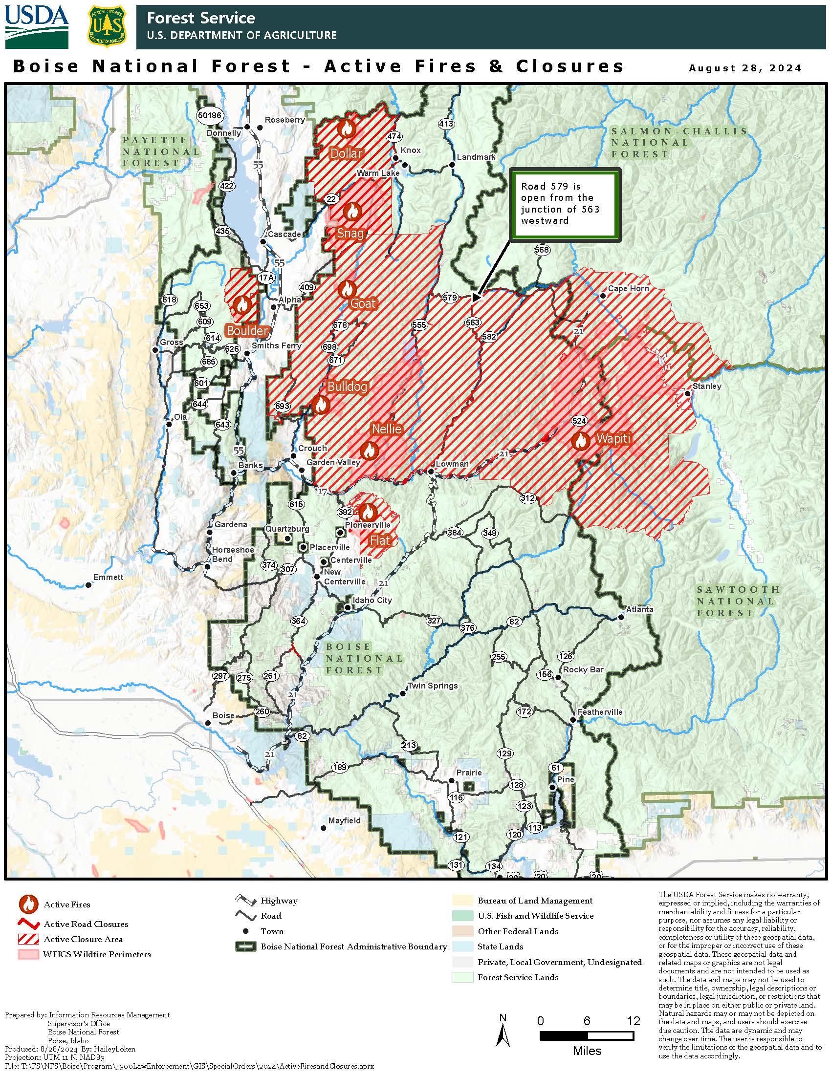
Middle Fork Complex Fire Update for Thursday 08 29 2024
Related Incident:
Publication Type: News
Middle Fork Complex Update
Thursday, August 29, 2024
Fire Size: 52,974
Completion: 5%
Total Resources: 890
Community Meeting
A community meeting is scheduled for Friday, August 30 at 6:00 p.m. at the White Barn Building near 85 Severance Road, Garden Valley, Idaho. The Incident Commander, key team members, and Boise National Forest representatives will provide updates on the fire and answer any questions.
Weather and Fire Behavior
Fire weather continues to impact the Middle Fork Complex area, leading to increased visible activity throughout the region. Low relative humidity during the day will decrease fuel moistures. Additionally, rising temperatures and strong winds have led to fire growth and spread, and this will likely continue. Cooler monsoonal moisture is expected later this weekend and into early next week.
Operations
Firefighters continue to build indirect containment line toward the Rattlesnake trail system in the Silver Creek area on the Bulldog Fire. They have completed structure protection preparation for Silver Creek and Boiling Springs and have secured the Middle Fork corridor along the fire’s western edge.
Crews in the Deadwood Reservoir area continued to work directly along the edge of the Nellie Fire as it approaches the Bearskin and Pioneer burn scars, which are slowing its growth. Fire activity east of the reservoir continued to be moderate yesterday, leading to heavy afternoon smoke as the fire pushed toward previous fire scars with low fuel.
On the southwest side of the fire, from Highway 17 near the Danskin boat launch, a burnout operation was finished from Anderson Creek to the highway. Crews will continue working north toward the fire’s edge and, if weather conditions remain favorable, will extend the burnout operation to strengthen containment lines.
Closures: The Boise National Forest has issued Order Number 0402-06-60, effective August 23, 2024. Highway 21 is closed from the Sourdough Lodge in Lowman to Stanley (MP 84 to 130) due to wildfire activity. Only local traffic is permitted between the Sourdough Lodge and Warm Springs Airstrip. For additional information, visit https://511.idaho.gov/
Temporary Flight Restrictions (TFR): A TFR is in effect over the fire area. It is illegal for the public to fly drones over or near wildfires due to the risk of accidents and interference with firefighting efforts.
Wildfire Preparedness Always be Ready Teton County 08 29 2024
Related Incident:
Publication Type: Announcement
Contact: Rich Ochs, Coordinator Teton County Emergency Management
Email: rochs@tetoncountywy.gov
Phone: 307-732-8594
For Immediate Release
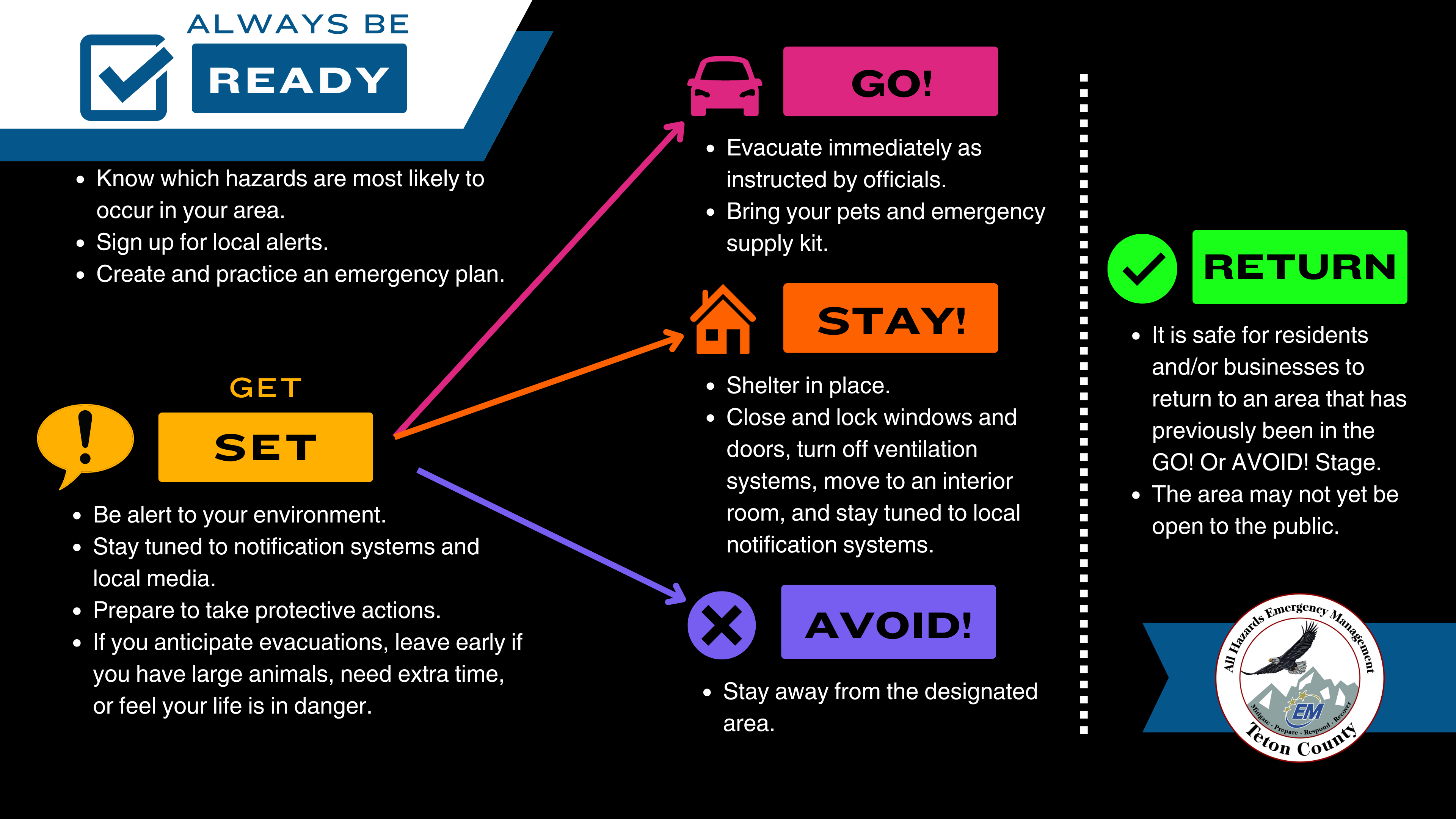
Wildfire Preparedness: Always be Ready
August 29, 2024, Jackson, Wyo. – The Fish Creek Fire is burning on the Bridger-Teton National Forest and has prompted our neighbors in Fremont County to put several areas in a pre-evacuation stage.
Though no protective actions have been ordered in Teton County, smoke is in the air which is always a good reminder to make sure that you are READY.
Being READY means being prepared in advance of a disaster or emergency. Don’t wait for someone to tell you – you should be ready year-round for hazards that are likely in our community. Take time today to make sure you have completed the steps below.
- Sign up for local emergency alerts. Tell your neighbors to do the same! Teton County’s free subscription-based alerting system is called Teton_WY Alerts. Click HERE or visit tcincident.org to register.
- Understand protective actions. Teton County uses Ready, Set, GO/ STAY/ AVOID! See the graphic below. Visit https://tetoncountywy.gov/1846/Ready-Set-GO-STAY-or-AVOID for more.
- Review and practice your emergency plan. See ready.gov/plan for steps and templates.

Expanded Closure Area for Wapati Fire Adjoins Middle Fork Closure 08 29 2024
Related Incident:
Publication Type: Announcement
Boise National Forest has expanded the closure order for the Wapati Fire. The closure has expanded west to adjoin the Middle Fork Fire Complex. Closed Forest Service Roads now include 582, 555, and 563, among others.
Park Fire Evening Update 08 28 2024
Related Incident: Park Fire
Publication Type: News
Park Fire Evening Update for August 28 is posted on the Park Fire Status Update Page
Wapiti Fire Community Meeting Stanley ID Thursday 08 29 2024
Related Incident:
Publication Type: Announcement
WAPITI FIRE COMMUNITY MEETING
Thursday, August 29, 2024, 6 p.m.
Stanley Community Building, 500 Eva Falls Avenue, Stanley, Idaho
The Rocky Mountain Complex Incident Team 1 members and local authorities will provide information on the status of the Wapiti Fire.
There will also be a virtual option, if internet service allows. The meeting will be livestreamed, and the recording later posted to the Wapiti Facebook Page. https://facebook.com/wapitifireinfo2024
Reduction in the Pyramid Closure Order 0618032432 09 04 2024
Related Incident: North Willamette Complex
Publication Type: Closures
Forest Service News Release
Contact Title: Breanne Schnell
(541) 285-8807
breanne.schnell@usda.gov
https://www.fs.usda.gov/willamette/
Reduction in Pyramid Fire closure order reopens recreational sites
Springfield, Ore. – Aug. 28, 2024. The Willamette National Forest has reduced the emergency closure
order issued for the Pyramid Fire, which was reported July 17 in the Sweet Home Ranger District.
The closure order rescinds order 06-18-03-24-30 and is effective Aug. 28, 2024, through Nov. 15,
2024, unless modified or rescinded sooner.
The lightning-caused Pyramid Fire, located east of Sweet Home, is approximately 1,312 acres in size
and 98% contained.
Recreation sites now open include Crescent Mountain Trail #3384, North Pyramid Trail #3383,
Pyramids Trail #3380, and Scar Mountain Trail #3402, Big Springs Sno Park, Coffin Mountain
Trailhead, Crescent Mountain Trailhead, Daly Lake Day Use/Campground, Maxwell Butte Sno Park, Lava
Lake, North Pyramid Trailhead, and Pyramids Trailhead. All roads and trails serving as the closure
boundary, such as FSR-11 and the North Pyramid Trail, are open for travelers.
Trails and recreation sites that remain closed include Bridge to Nowhere Trail #3377 and Trailhead,
Chimney Peak (Shedd Camp) Trail #3382 and Trailhead, Gordan Peak Trail #3387 and Trailhead, McQuade
Creek Trail #3397 and Trailhead, Parish Lake Trail #3383 and Trailhead, Pyramids Bypass Loop #3376,
Riggs Lake Trail #3388 and Trailhead, Swamp Peak Trail #3401 and Trailhead, South Pyramid Creek
(west of Cresent Mountain Trail #3403) Trail and Trailhead, Blowout Bridge Trailhead, Middle
Santiam Wilderness, Scar Trailhead, and South Pyramid Horse Campground.
For a map of the closure area and a complete list of recreation sites and roads included in the
order, visit our website at https://www.fs.usda.gov/alerts/willamette/alerts-notices.
Please be aware of current restrictions before you head out into the forest and share information
with others. As fire restrictions change, information will be available at
https://www.fs.usda.gov/main/willamette/fire.
Follow us on Facebook and Twitter @WillametteNF for the latest updates. To report a wildfire,
please call 9-1-1.
###
USDA is an equal opportunity provider, employer and lender.
Williams Mine Fire Area and Road Closure Revised 08 28 2024
Related Incident: Williams Mine Fire-GPNF
Publication Type: Closures
ORDER NO. 06-03-03-24-03
GIFFORD PINCHOT NATIONAL FOREST
Mount Adams Ranger District
Trout Lake, Washington
WILLIAMS MINE AREA AND ROAD CLOSURE
This closure order supersedes Closure Order 06-03-03-24-02.
Pursuant to 16 U.S.C. § 551 and 36 CFR 261.50 (a) and (b), the following acts are prohibited on the area described in this order and depicted on Exhibit A, within and/or administered by the Gifford Pinchot National Forest, Mount Adams Ranger District, until further notice:
1. Going into or being upon the area affected by the Williams Mine Fire (36 CFR 261.52(e))
2. Being on a road. [36 CFR § 261.54(e)].
PURPOSE:
The purpose of this order is to protect public health and safety due to the Williams Mine fire, as well as to allow for safe and efficient firefighting operations.
AREA CLOSURE:
The following description serves as the exterior boundary and closes all lands encompassed within it as depicted in attached Exhibit A:
From a point of beginning on National Forest System (NFS) Road 2300 (posted 23), approximately 3 miles north of Trout Lake, in the southeast corner of Section 33, T7N, R10E; then approximately 17 miles north to the junction of NFS Road 2300 and NFS Road 2329 in the northwest corner of Section 17 T9N, R10E; then east-north-east on NFS Road 2329 approximately 7 miles to the junction of NFS Road 2329 and NFS Road 5603 in the northwest corner of Section 23, T10N, R10E; then east on NFS 5603 approximately 2 miles to the eastern boundary of the Gifford Pinchot National Forest (GPNF) in the northwest corner of Section 30, T10N, R11E; then south along the GPNF eastern boundary approximately 20 miles to Section 33, T7N, R11E; then west along the southern GPNF boundary to NFS Road 2300, to the point of beginning, in the southeast corner of Section 33, T7N, R10E.
The following road surfaces along the Area Closure are open to public traffic, but only to the extent of the graded or surfaced area of the roadway
• NFS Road 2300 north from its junction with NFS Road 90 in the southeast corner of Section 25, T9N, R9E.
• NFS Road 2329 from its junction with NFS Road 23 in the northwest corner of Section 17 T9N, R10E; then east-north-east on NFS Road 2329 approximately 7 miles to the junction of NFS Road 2329 and NFS Road 5603 in the northwest corner of Section 23, T10N, R10E.
• NFS Road 5603 from its junction with NFS Road 2329 in the northwest corner of Section 23, T10N, R10E to the eastern boundary of the GPNF in the northwest corner of Section 30, T10N, R11E.
ROAD CLOSURE:
Travel is prohibited on the following National Forest System (NFS) Roads as described below and shown on the attached map (Exhibit A).
• NFS Road 2300 from its origin at the southern boundary of the Gifford Pinchot National Forest in the southeast corner of Section 33, T7N, R10E to its junction with NFS Road 90 in the southeast corner of Section 25, T9N, R9E.
EXEMPTIONS:
1. Any Federal, State, or County officer, or member of an organized rescue or firefighting force in the performance of an official duty.
2. Persons with Forest Service Permit No. FS-7700-48 (Permit for Use of Roads, Trails, or Areas Restricted by Regulation Order), specifically exempting them from this order.
3. Persons traveling for evacuation purposes.
These prohibitions are in addition to the general prohibitions in 36 CFR Part 261, Subpart A.
Violation of these prohibitions is punishable by a fine of not more than $5,000 for an individual or $10,000 for an organization, or imprisonment for not more than 6 months, or both (16 U.S.C. § 551; 18 U.S.C. §§ 3551, 3559, 3571, and 3581).
Executed in Vancouver, Washington, this 28th day of August 2024.
Johanna Kovarik
Forest Supervisor
Gifford Pinchot National Forest