
Hwy 87 Closure ADOT 07 28 2024
Related Incident: Sand Stone
Publication Type: Closures
Southbound State Route 87 is closed between State Route 188 and Bush Highway due to the #SandStoneFire. Motorists are advised to expect delays and seek an alternate route.
There is no estimated time to reopen the southbound lanes. The northbound lanes are unaffected.
For real-time road information, use the AZ511 app:
Apple https://bit.ly/4cpuuV3
Android https://bit.ly/3orb7Ca
Media Update 72727 PM Courtrock 07 27 2024
Related Incident: Courtrock Fire
Publication Type: News
Fire activity on the Courtrock Fire increases, resources engaged with aircraft, active ground suppression, and structural protection
MONUMENT, Ore. – Wind, heat, record dry vegetation and topography continue to drive growth on the Courtrock Fire. With less smoke and more visibility, multiple helicopters, including from the Oregon National Guard, were able to deliver water drops today on the southwest and southeast portions of the fire.
Media Update 72627 PM Courtrock 07 26 2024
Related Incident: Courtrock Fire
Publication Type: News
MONUMENT, Ore. – Firefighters suppressing the Courtrock Fire continued to expand containment lines along the eastern and western perimeter with the goal of pinching off the head of the fire where it’s been progressing in the southeast.
Bluff Creek Complex Daily Update 07 28 2024
Related Incident:
Publication Type: News
Bluff Creek Complex
Idaho Panhandle National Forests
Fire Information 208-557-8813
https://inciweb.wildfire.gov/incident-information/idipf-bluff-creek-complex
July 28, 2024
Idaho Panhandle Type 3 Incident Management Team
Incident Commander Brian Hicks and Incident Commander Trainee Bryce Barth
Location: The fires are burning along both sides of the Bluff Divide, approximately 13 1/2 miles southeast of Avery, ID; five and a half miles west from Gold Creek Campground; and approximately two miles northwest of Junction Ridge.
Start Date: 7/25/2024 Cause: Lightning Size: 425 acres
Completion/Containment: 0%
125 Total Personnel:
1 Engine
1 Type 2 Hand Crew
2 Interagency Hotshot Crews
5 Heavy Equipment
1 Water Tender
Key Message:
With the national Planning Level of 5
Current Status:
The Bluff Creek Fire consists of four different fires: Junction Fire, East Fork Fire, Dominion Point Fire, and Buffalo Fire. As of last night, the Junction Fire increased to 250 acres; the East Fork Fire increased to 25 acres; the Dominion Point Fire increased to 150 acres; and the Buffalo Fire has remained around 1/10th of an acre.
All available resources are engaged in suppression, working on these fires based on priority order. Due to the immediate threat to values at risk, including private industry timberlands, active logging sales, and equipment, the Junction Fire remains priority. Active fire behavior led to spot fires crossing a road on the north end of the fire yesterday, but crews were able to contain the spot fires and hold the road. Heavy equipment utilization has increased accessibility for crews to more safely and effectively engage in the fire, and accessibility improvements will continue throughout today. Today’s focus will be on the eastern portions of the fire, where crews will be engaging directly where feasible to do so.
On the East Fork Fire, one hotshot crew worked to gain safe access to the fire and were able to start engaging directly on the eastern portion. Today, professional fallers will further secure workable spaces, falling large dead standing snags that pose a significant risk to firefighter safety. On the Dominion Point Fire, crews worked on opening up access to the area and planning engagement tactics. Today, they will prioritize the southern portion of the fire, directly on Dominion Point. The Buffalo Fire remains at one tenth of an acre, burning in heavy dead and down fuels.
Weather and Fire Behavior
Temperatures today will be slightly cooler, ranging from 78-85 in the valleys and 68-78 in mountains. Relative Humidity is slightly increased, ranging from 25%-40%. Winds will be breezy, with potential for gusts up to 20 mph in the lower slopes/valleys and 25 mph in the upper slopes/ridges. Tomorrow there is a slight chance of rain showers in the late morning and afternoon.
Closures and Special Messages
Closures surrounding both fire areas are necessary to protect the safety and welfare of the public and provide for safe firefighting efforts and access. Specific closure information and maps are posted on InciWeb at https://inciweb.wildfire.gov/***** and https://www.fs.usda.gov/ipnf as they are implemented.
The Bluff Creek Complex closures include the following roads and area:
- CLOSED:
- Forest Development Road 509 beginning at its junction with County Highway 50 and concluding at its intersection with Forest Development Road 201.
- Forest Development Road 1258 beginning at its junction with Forest Development Road 509 concluding at its intersection with Forest Development Road 201.
- Forest Service Development Road 1956F beginning at its junction with Forest Development Road 509 and concluding at its junction with Forest Development Road 3338.
- Forest Development Road 322 beginning at its junction with Forest Development Road 201 concluding at Conrad Peak.
- Gold Flat Camp Area: Gold Flat undeveloped campsite located 8.6 miles North on Forest Development Road 218 from Red Ives Cabin. Gold Flat undeveloped campsite is located within Section 23 and 24 in T16N, R30W. The area Gold Flat undeveloped campsite where defined on the map comprises of 6.2 acres bordered by the St. Joe River on the West and Forest Development Road 218 on the East.
At this time, a TEMPORARY FLIGHT RESTRICTION is in place for 27NM SE KELLOGG, Idaho near MULLAN PASS VOR/DME (MLP). No pilots may operate an aircraft in the areas covered, including drone pilots.
Fire Update 07 28 2024
Related Incident: Currant Creek Fire
Publication Type: News
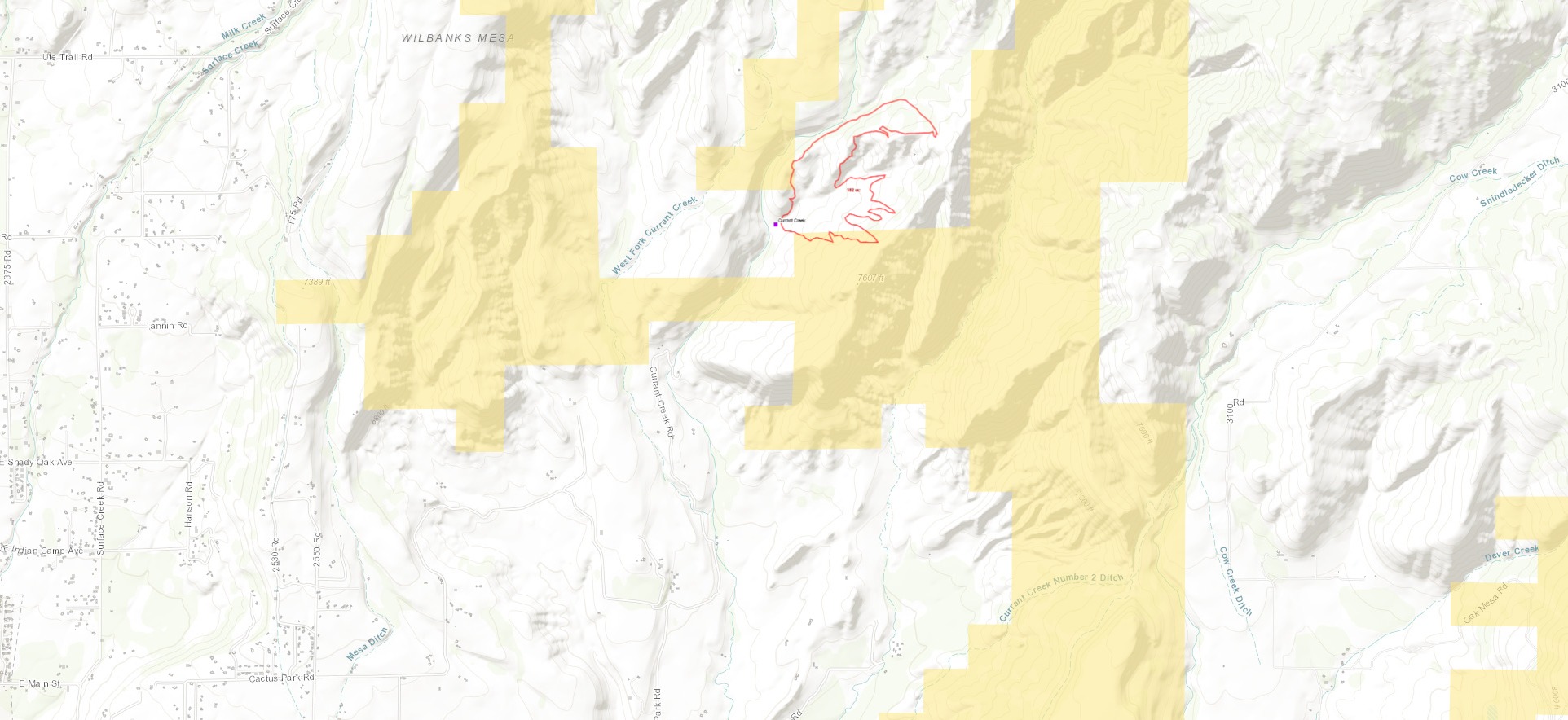
Currant Creek Fire Update - Sunday, July 28, 2024
11:30 am
----------------------------------------------------------------
The Delta County Sheriff’s Office is providing a morning update on the Currant Creek Fire east of Cedaredge near Redlands Mesa. The fire is still burning but fire growth was knocked down substantially Saturday afternoon and evening thanks to the efforts of the Cedaredge Fire Protection District, Hotchkiss Fire District and crews from the Bureau of Land Management (BLM) and aviation assets.
A type 1 helicopter and four single engine air tankers performed water and fire-retardant drops on the fire Saturday afternoon following a brief thunderstorm that moved through the area and provided much needed rain and hail over the fire. This moisture combined with the water and retardant drops significantly altered fire behavior and caused the fire to lay down and stop progressing at a rapid pace. The fire is burning in pinon-juniper forest, oak brush and other brush types in steep terrain which is a challenge for fire crews.
The majority of the fire is contained on private property as of 7:00 am Sunday morning. On Saturday evening, the Cedaredge Fire Protection District turned the fire over to the Delta County Sheriff’s Office as a county responsibility fire. The Sheriff’s Office then formally requested the CO Division of Fire Prevention and Control (DFPC) assume command and control of the fire as a State Responsibility fire and that request has been granted as of Sunday morning. The Fire is being managed by Incident Commanders from the BLM with assistance from DFPC.
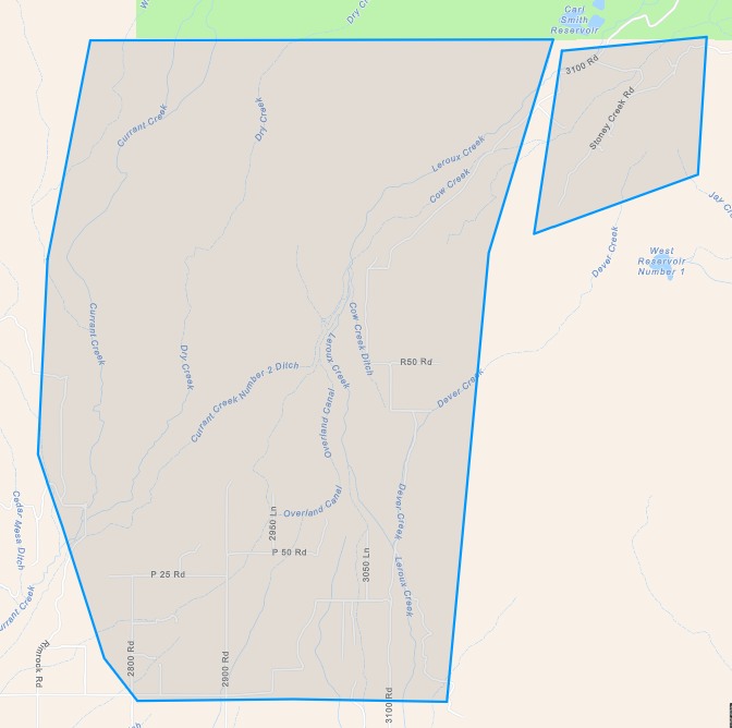
The CO Multi-Mission Aircraft (MMA) utilizing state of the art infrared cameras and software has mapped the fire at approximately 182 acres as of Saturday evening. An image of the current boundary and size of the fire has been included to show the location of the fire in location to 3100 Road and other residences in the area.
At the recommendation of the Fire Incident Commanders, Fire Chiefs from Hotchkiss and Cedaredge Fire Protection Districts, and the Delta County Undersheriff, the pre-evacuation status for residents of upper Redlands Mesa and Leroux Creek as noted below will remain in effect until incident commanders can report more containment on the fire with the pending red flag conditions.
Pre-Evacuation Area: The pre-evacuation notice applies to residents who live on 3100 Road north of Redlands Mesa Road to the Forest Service Boundary and West along Redlands Mesa Road to Rim Rock Road and Currant Creek north to the forest service boundary. A polygon shape from the Delta County Alert issued on Saturday, July 27th is included to show this area. The Pre-Evacuation Notice means residents should be taking preparations to leave in the event the fire grows and starts progressing to the east or southeast towards residences. Pre-evacuation tips can be found online at US Fire Administration’s Website (https://www.usfa.fema.gov/.../wildfire-evacuation...) .
Fire crews held a briefing Sunday morning at 7:00 am and multiple engine crews and two type-two hand crews remain on the fire today and are working hard to establish containment lines around the fire. Additional resources have been ordered to suppress the fire and will arrive mid-day today. The National Weather Service has forecast Red Flag Warnings for across Delta County today. This means low relative humidity, low moisture levels in fuels and the potential for high winds which can drive fire growth. Fire crews have informed the county their main objective is to improve containment and address hotspots on the fire to prevent flare up and increased fire behavior as red flag conditions persist this afternoon.
The cause of the fire is currently under investigation by the Delta County Sheriff’s Office and Bureau of Land Management. The Delta County Sheriff’s Office, Emergency Management, Delta County leadership, DFPC and BLM are working jointly to support fire suppression efforts on this fire and prevent future growth and risk to the residents of upper Redlands Mesa and Leroux Creek.
Fire updates will be shared as they become available and will be posted to the Delta County Website at DeltaCountyCO.gov/Alerts – click on the Currant Creek Fire button. Updates are also posted to the Delta County Alerts Facebook page and Delta County Sheriff's Office Facebook page.
We encourage all residents in the vicinity of the fire and across Delta County to be sure you are registered for Delta County Alerts by opting into emergency alerts by registering your home address, phone numbers and email address with Delta County Alerts. For more information on how alerts work and to sign up, please visit DeltaCountyCO.gov/Alerts.
PREEVACUATION STATUS 07 27 2024
Related Incident: Currant Creek Fire
Publication Type: Announcement
Wildfire Alert- Currant Creek - Near Cedaredge | Pre-Evacuation Notice .
Delta County Alert - This is a WILDFIRE ALERT for a new wildfire start near Currant Creek on the West end of Redlands Mesa and East of Cedaredge.
The Hotchkiss Fire Department and Cedaredge Fire Department are on-scene and requesting residents who live along Leroux Creek - 3100 Road north of Redlands Mesa Road and residents west of 3100 Road to Rimrock Road and North of Redlands Mesa Road in the P25 Road area start getting prepared and be ready to evacuate. The fire department is requesting you be in a PRE-EVACUATION status for this wildfire.
The wildfire is in the area of Currant Creek and Rim Rock Road and burning east. Strong winds are pushing the fire and homes in upper Leroux Creek should be ready to evacuate.
More information will be issued as it becomes available. Follow the Delta County Alerts Facebook page for more information at Delta County Alerts
Saturday, July 27, 2024 at 1503 hours
Public Land Closure Malheur National Forest 07 28 2024
Related Incident: Courtrock Fire
Publication Type: Closures
Closure area consists of all geographical areas on Forest Service land within boundaries of the Malheur National Forest, including all roads, trails, and areas of Blue Mountain Ranger District, Emigrant Creek Ranger District and Prairie City Ranger District.
Closure Order for the Bull Trout Fire Area 07 28 2024
Related Incident: Bulltrout Fire
Publication Type: Closures
Closure Order Issued for Bull Trout Fire Area
BOISE, Idaho, July 28, 2024 – The Boise and Salmon‐Challis National Forests have issued a closure order effective immediately for roads, trails and lands encompassing the Bull Trout Fire. The closure was enacted to protect public safety and support fire suppression activities.
The closure affects interior travel on several National Forest System (NFS) roads such as NFS 579, 582 and many others. The closure began Saturday, July 27 and will last through December 31, 2024, at 11:59 PM, unless rescinded. The closure boundary extends to the north to Bear Valley Creek along the Bear Valley Rd. (NFS 579), to the west-southwest along NFS 582, south to Castro Creek in the Eight Mile Mountain range, then east to the Lowman Ranger District boundary. There are no disruptions in access to the Boundary Creek Boat Launch. NFS Road 579 is open in its entirety from Highway 21 to NFS Road 568 to the Boundary Creek Boat Launch.
The Order Number is 0402-05-91. Find the legal description, map and documentation on the Boise National Forest Alerts and Notices page under the Lowman Ranger District. https://www.fs.usda.gov/alerts/boise/alerts-notices. See attached closure map.
For the Boise National Forest Fire Info Hotline call (208) 384-3266.
Contact: Dave Walsh, Fire Information Officer, Boise National Forest, 208-373-4105, david.walsh@usda.gov
Amy Baumer, Public Affairs Officer, Salmon-Challis National Forest, 208-756-7853, amy.baumer@usda.gov
###
Settings - change map background and toggle additional layers
Filter - control incident types displayed on map.
Zoom to your location
Reset map zoom and position
Could not determine your location.
Show Legend
 Wildfire
 Prescribed Fire
 Burned Area
Response
Burned Area
Response Other
Other
Borel Fire
Unit Information
Incident Contacts
Courtrock Fire Update Spanish Version 07 28 2024
Related Incident: Courtrock Fire
Publication Type: News
Los bomberos siguen manteniendo y asegurando más líneas de contención y las temperaturas serán un poco más leves
UKIAH, Ore.: Los bomberos junto con los equipos 1 y 3 del Departamento forestal de Oregón continúan avanzando entre los incendios del complejo Battle Mountain. Los equipos han construido más líneas de contención que están conectadas y reforzadas tanto en la zona I como en la II. Los leves cambios meteorológicos de hoy pueden poner a prueba algunas líneas, pero también ofrecerá una oportunidad para que los bomberos aseguren zonas que habían sido difíciles de controlar. El gran cambio se debe a la dirección del viento. Los vientos del oeste dominarán la zona de los incendios, que, sumados a la posibilidad de cielos despejados, podría ser una ayuda natural para bomberos y pilotos.
En la Zona I, los bomberos tuvieron una buena noche en general. En el extremo suroeste, los equipos pudieron realizar operaciones de quema estratégica para reforzar la línea entre el incendio y las viviendas dispersas en el área. Hoy, los bomberos neutralizarán estas zonas para reforzar las líneas, y las fuerzas especiales del Alguacil de incendios del estado de Oregón (OSFM, en inglés) continuarán las operaciones de protección de estructuras. Estas medidas también se realizarán en el noroeste. Los vientos del oeste que llegarán por la tarde podrían, de forma natural, ayudar a empujar el fuego lejos de la línea de contención y dirigirlo hacia el interior del incendio.
Al sur de la Zona I, los bomberos siguen manteniendo y reforzando la línea desde Monument hacia el este, y hoy concentrarán los esfuerzos en profundizar la centralización de estas zonas. Hacia el norte, los equipos continúan la construcción de las líneas. Gran parte de este terreno es de difícil acceso y la construcción de una línea sólida puede ser todo un desafío. Sin embargo, los equipos utilizaron operaciones de quema estratégica como una herramienta beneficiosa para detener el crecimiento del incendio.
En la Zona II, los bomberos aprovecharon las condiciones meteorológicas más suaves para aumentar los recursos y recortar la línea a lo largo del perímetro noreste para salvar unos 400 acres adicionales de terreno forestal.
Tyler McCarty, comandante del incidente del equipo 3 de la ODF declaró que: “Esta es otra de las victorias que esperábamos alcanzar. Estamos muy orgullosos de los bomberos y de nuestro personal de operaciones por saber aprovechar esta oportunidad. Esto protegerá muchas viviendas de la zona, reducirá los acres afectados por el incendio y protegerá los recursos naturales de la comunidad”.
En el extremo sur del incendio, los equipos realizaron operaciones de quema para eliminar vegetación sin quemar, y utilizaron buldóceres en la Zona I, hacia el oeste, para minimizar el crecimiento.
Por otra parte, en la Zona II, los bomberos lograron mantener y asegurar las líneas mientras extinguieron incendios más pequeños que eran detectados o aparecían en los cortafuegos. Los equipos comienzan las obras de neutralización en más áreas de la Zona II donde las líneas son más seguras. Asimismo, continuarán las actividades de neutralización en el incendio de North Fork Owens, al norte del incendio de Monkey Creek.
Evacuaciones: Se encuentran vigentes los niveles de evacuación 1 (Estar preparado), Nivel 2 (Preparado para evacuar) y Nivel 3 (Evacuar de inmediato). Para tener información actualizada, visite:
- Para el condado de Umatilla, siga en www.facebook.com/UmatillaCountySheriff o suscríbase al sistema de alertas de emergencia del condado de Umatilla en https://member.everbridge.net/index/2590041373147145.
- Para el condado de Grant, visite el sitio web RAPTOR arcgis o suscríbase para recibir alertas en: https://member.everbridge.net/index/825462649520134.
Para el condado de Morrow, visite https://experience.arcgis.com/experience/de78333b0d2544f7a320142174aa20ae