
Microwave Tower Fire Update Sunday 07 28 2024
Related Incident: Microwave Tower Fire
Publication Type: News
Fire Information: Phone: (541) 208-1744 daily from 8 a.m. - 8 p.m.
Email: 2024.microwavetower@firenet.gov
Microwave Fire Facebook: https://www.facebook.com/2024MicrowaveTowerFire/
InciWeb: https://inciweb.wildfire.gov/incident-information/or954s-microwave-tower
53% Contained
170 Personnel
1062 Acres
5 miles west, southwest of Mosier, OR
Burning in brush, timber, and grass
Highlights
Yesterday’s westerly winds helped pull smoke and heat back into the fire area during the strategic burning operations, enabling aircraft to support ground firefighters with water drops. Crews also made significant progress, mopping up approximately 150 feet along the eastern, southern, and western containment lines. This effort focused on identifying and extinguishing hot spots to prevent further spread.
Due to the steep terrain, rolling debris and gusty, westerly winds last night, the fire crossed below the Historical Columbia River State Trail to the railroad tracks, reaching the secondary dozer line. This has created new challenges for firefighters. They will continue to improve containment lines and hold the fire from advancing beyond the current fire perimeter. Aviation support will be utilized as soon as possible today, weather and wind permitting. Aircraft plays a role in cooling down hot spots and providing additional support to ground crews. Lane restrictions are in place along Interstate 84, with one eastbound lane currently closed. Motorists are advised to exercise caution while driving in the area.
A community meeting will be held tonight at 7:00 p.m.in Mosier. The meeting location will be announced via the social media links located above and InciWeb as soon as a facility is identified. Residents are encouraged to attend to receive updates on the firefighting efforts and to ask questions.
A transfer of command for the incident will occur on Monday, July 29, 2024, at 6 a.m. A local Type 3 Incident Management Team, led by Incident Commander Jeremy Goers, will assume command of the firefighting efforts. This transition aims to ensure a seamless continuation of operations and community support.
Fire Behavior
Fire behavior will be active along the northwest flank from firing operations. Expect an increase in smoke production, visible from I-84. Within the contained firelines, pockets of fuels are critically dry, expect to see active fire behavior.
Evacuations
Existing Level 3, 2 and 1 evacuations on the east side of the fire area remains in place. For updated information please follow https://www.facebook.com/WascoCountySheriff. Stay informed through official channels for the latest update.
The evacuation preparedness level remains at Level 1 on the west side of the fire area. Please follow https://www.facebook.com/hrcso for additional information. The Red Cross center is available at the Hood River Middle School for anyone needing a place to go.
Ore Fire Update 07 28 2024
Related Incident: Ore Fire
Publication Type: News
Ore Fire Update
Sunday, July 28, 2024 – 9:30 a.m.
Size: 1400 acres | Reported Date: July 16, 2024 | Cause: Under Investigation | Containment: 20%
Total Assigned Personnel: 327 | 8 engines | 5 hand crews | 3 dozers | 20 water tenders | 5 masticators | 4 feller bunchers
An Ore Fire Community Meeting is scheduled today, Sunday, July 28, 2024, at 2 p.m. in the McKenzie High School Gymnasium. A recording will be posted to the Ore Fire Facebook Page following the meeting.
(Blue River, Ore.) – Fire suppression efforts continue on the Ore Fire, which is burning 7 miles northeast of Blue River, Oregon. Challenges include steep and rugged terrain, rolling rocks and debris, and fire-weakened trees. Firefighter and public safety remain the number one priority on the incident. Fire managers are focusing on activities with a high probability of success while minimizing risk to firefighters and protecting values such as communities, infrastructure and forest, recreation and cultural resources. Firefighters face an inherent risk associated with fighting wildfires, but mitigation efforts and proper planning can reduce the overall dangers to responders.
Yesterday, firefighters successfully held the edge along the FS 15 and 1509 Roads as more fire backed down to the containment lines. Ground crews cleared a helicopter landing zone to the north of the fire to reduce extraction time in case of serious firefighter injury. Along FS 1509 Road, firefighters patrolled and monitored from the west side of Tidbits Creek to minimize the exposure from boulders and logs rolling onto the roadway. Heavy equipment operators are improving roads to provide safer access routes for the personnel on the fire line.
Today, crews are concentrating on holding the southern perimeter of the fire. Woody debris removal and road improvements are ongoing. The FS 827 Road is being cleared to provide access north of the fire. Chipping operations are underway to remove large piles of heavy debris and improve access to the fire's edge.
After identifying strategic actions in the Incident Strategic Alignment Process (ISAP), information is gathered to evaluate the associated risks to responders. This involves considering factors including ground transportation, fire behavior, gravity hazards, aviation operations, human factors, and medical response time and capability. Fire managers identify ways to reduce these risks before deciding on which strategic actions are appropriate. Visit the incident’s Facebook page to learn more about ISAP at https://www.facebook.com/OreFireInformation2024.
Weather: Today, highs will be in the mid-70s at ridgetops and near 80 at the lower elevations. On Monday, breezy southwesterly winds are expected ahead of an approaching cold front. Rain chances will increase as incoming moisture introduces the chance for scattered showers over the fire. Thunderstorms are not likely.
Safety: Firefighters are reporting an increasing number of motorists traveling into the closure area where crews are actively working to contain the fire. Forest closures are in place for the safety of everyone. The public is asked to remain clear of the fire area and allow firefighters to safely complete their work. Fire restrictions are in effect. For more information, visit https://www.fs.usda.gov/main/willamette/fire. A Temporary Flight Restriction (TFR) is in place over the fire area. Unstaffed Aerial Systems (UAS or drones) are prohibited within the TFR. If you fly, we can’t.
Smoke: Smoke from numerous wildfires burning throughout the region will affect air quality in many areas over the coming days. A daily smoke outlook can be found at https://wildlandfiresmoke.net. Being prepared for smoke is important. For more information, go to: www.airnow.gov/wildfires/be-smoke-ready.org.
Forest Closures: Closures on the Willamette National Forest have been established around fire-impacted areas, including the following sites: Buck Mountain Trail, Tidbits South and West Trail, Gold Hill Trail, Mona Campground, Lookout Campground, and Saddle Dam Boat Launch. For a complete list of recreation and roads in the Ore Fire closure order, visit https://www.fs.usda.gov/alerts/willamette/alerts-notices.
Badland Complex Update for 07 28 2024
Related Incident: Badland Complex 2024
Publication Type: News
Badland Complex Fire Update
July 28, 2024
Rocky Mountain Area Complex Incident Management Team Two
Jared Hohn, Incident Commander
Current Situation:
- The Badland Complex has grown to 54,416 acres and is 0% contained with 228 personnel assigned.
- Yesterday, the Coyote fire grew approximately 3,000 acres. Smoke jumpers are continuing to mop up and secure control lines, working in steep and rough country along the southern edge of the fire.
- On the Thompson fire, crews constructed hand lines on the northern edge. On the west side, ground and air resources secured an area of active fire totaling approximately 40 acres. Additional night resources arrived to monitor and hold this area throughout the night. A UAS (unmanned aircraft system) with IR (infrared) will be used today to detect remaining areas of heat. Previously, smoke and the lack of available aircraft has prevented gaining aerial recon.
- More firefighting resources will be arriving today, including a skidgine and additional engines. Nationally, there is a high level of fire activity demanding a limited supply of shared interagency firefighting resources.
- The Powder fire is still holding with no growth. Firefighters will continue to monitor and mop up any heat sources.
- Temperatures will continue to warm throughout the week, which is predicted to increase fire behavior. Smoke will remain heavy.
Weather & Smoke Information: Weather will be warmer than yesterday and will continue to warm throughout the week. Temperatures will be 80s on the ridgetops, 90s in the valleys. Humidity 15-20%. Winds will be 20-25 mph from 8 pm - midnight.
An air quality advisory is in effect for Baker County due to heavy concentrations of wildfire smoke. For current Oregon air quality conditions, please visit https://oraqi.deq.state.or.us/home/map.
Evacuations: Baker County Sheriff’s Office has issued Level 1, 2, and 3 evacuation orders for multiple areas of the fire. Learn more at https://www.facebook.com/profile.php?id=100064434892363. Sign up for Baker County emergency alerts at https://public.alertsense.com/SignUp/publicUser.aspx?regionid=1357
Closures: Check for highway closures at https://www.tripcheck.com/DynamicReports/Report/RoadConditions. All BLM Vale District Recreation Sites along the Snake River between Oxbow and Huntington and on Lookout Mountain are closed. This includes Spring Recreation Site, Swedes Landing, and Bassar Diggins Campground.
Fire Restrictions: Fire Restrictions are in effect. Get details at https://www.blm.gov/sites/default/files/docs/2024-07/orwa-fpo-val-071024.pdf.
Temporary Flight Restrictions: A temporary flight restriction (TFR) is in effect over the fire area to provide a safe environment for firefighting aircraft operations. View a map of the TFR and details at https://tfr.faa.gov/save_pages/detail_4_7614.html. Fire aviation response is halted or delayed if an unauthorized aircraft enters the TFR. Temporary flight restrictions also apply to unmanned aircraft systems or drones. If you fly, we can’t! Learn more about how to use drones safely and responsibly at Home - Know Before You Fly.
Fire Info Phone: 541-362-1507 Email: 2024.badlandcomplex@firenet.gov Hours: 7:00 a.m. to 7:00 p.m.
Facebook: @BadlandsComplexFires2024 Media Line: 541-249-5894
Inciweb: https://inciweb.wildfire.gov/incident-information/orvad-badlands-complex-2024
Actualizacin diaria del incendio Retreat 28 de julio 07 28 2024
Related Incident: Retreat
Publication Type: News
Equipo 1 de Northern Rockies, Comandante del Incidente Brent Olson
Ubicación: 14 millas al suroeste de Naches, WA
Fecha de inicio: 23 de julio de 2024
Causa: Bajo investigación
Tamaño: 22.237 acres
Recursos: 354 personas en total; 8 excavadoras; 7 cuadrillos de bomberos; 36 camiones de bomberos.
MENSAJE CLAVE:
Habrá una reunión comunitaria mañana, lunes 29 de julio a las 6:00 p.m. en la cafetería de la Escuela Primaria Naches Valley ubicada en 151 Bonlow Dr. Naches, WA 98939. También habrá un componente virtual en la página de Facebook del incendio Retreat.
SITUACIÓN ACTUAL:
Han llegado bomberos y equipos adicionales que han sido asignados a varios puntos del incendio. Dados los vientos esperados y el movimiento del humo, es posible que se observe un comportamiento activo del fuego. El incendio se encuentra actualmente bajo una estrategia de supresión total, dando prioridad a la seguridad pública y de los bomberos. En el lado este se está empleando una combinación de tácticas directas e indirectas a lo largo de Cowiche Road, Hatton Road, Bethel Ridge Road y Highway 12 para detener el movimiento del fuego y asegurar el borde del incendio.
Equipos pesados y cuadrillas de bomberos están trabajando en líneas directas e indirectas a lo largo del lado norte y sur del incendio para minimizar el avance del fuego. Los recursos operativos continúan realizando reconocimientos a lo largo del lado oeste en busca de posibles ubicaciones de líneas indirectas para evitar una propagación adicional del incendio hacia el lago Rimrock. Las operaciones de fuego están en curso en el flanco oriental del incendio a lo largo de Bethal Ty Road hacia la autopista 12, y desde la carretera 642 hasta Hatton Road. En los próximos días están previstas más operaciones de quema en las mismas zonas generales. Los recursos de protección de estructuras siguen apagando focos de incendio cerca de viviendas e infraestructuras a lo largo de la autopista 12 y también están realizando trabajos de evaluación y preparación cerca de Camp Ghromley y Lost Lake Road.
METEOROLOGÍA Y COMPORTAMIENTO DEL FUEGO:
Hoy se observarán temperaturas estacionales sobre el incendio Retreat, con temperaturas generalmente en los 70, y valores mínimos de humedad relativa en torno al 28-34%. Los vientos del oeste comenzaron a aumentar por la tarde y seguirán aumentando durante la noche a medida que una vaguada de onda corta se desplace por la región. Se espera que los vientos del oeste-noroeste persistan durante la noche hasta el domingo, alrededor de 10-20 mph con rachas de 20-30 mph, especialmente sobre las crestas. Se esperan buenas recuperaciones de humedad relativa durante la noche. Para el domingo se esperan condiciones meteorológicas similares, con una humedad relativa ligeramente superior.
Existen tres tipos principales de combustible: salvia/hierba, fondos de roble y bosques de ponderosa. La hierba en los tipos de combustible apropiados está completamente curada y disponible fácilmente para la ignición. Aunque los robles no se están consumiendo, los intensos incendios de hierba bajo estos árboles están produciendo grandes brasas visibles a corta distancia.
CIERRES Y EVACUACIONES:
Aviso de evacuación de nivel 3 "IR AHORA " desde US Hwy 12 en Bear Canyon Trailhead (NF 1301 Forest Service Road) hacia el noreste hasta la "Y" (Hwy 12/410). Desde la "Y" (autopista 12/410) hacia el sur a lo largo de los límites de los municipios de Cowiche y Tieton hasta Cowiche Mill Road. Cowiche Mill Road oeste hasta NF 641 Forest Service Road.NF 641 Forest Service Road norte hasta Hwy 12.
Aviso de evacuación de nivel 2 "GET SET" para el área de la ciudad de Tieton, WA, incluyendo Cowiche Mill Road al este hasta Summitview Road, Summitview Road al norte hasta la parada de cuatro vías en West Tieton Road, en dirección oeste por West Tieton Road hasta el final de West Tieton Rd. El límite oeste es el final de West Tieton Road en dirección sur hasta el bloque 3600 de Cowiche Mill Road. Para conocer los límites de la evacuación, visite la página de Facebook de la Oficina de Emergencias del Condado de Yakima: www.facebook.com/YakimaCountyOEM/.
- La US Hwy 12 permanece cerrada por varios motivos entre la Y de la Hwy 410 y el cumbre del collado en el punto kilométrico 151.
- Cierre de la zona de incendios del Bosque Nacional Okanogan-Wenatchee: www.fs.usda.gov/alerts/okawen/alerts-notices/?aid=89192.
- La Región Sureste del Departamento de Recursos Naturales del Estado de Washington (DNR) ha cerrado temporalmente el Bosque Estatal de Ahtanum debido al aumento de la actividad del incendio adyacente Retreat Fire que quemando cerca de Rimrock Lake. El público puede acceder a la información más actualizada sobre cierres en www.dnr.wa.gov/ahtanum.
- El Departamento de Pesca y Vida Silvestre de Washington ha cerrado al público la mayor parte de la zona de Oak Creek debido al incendio de Retreat, que permanecerá cerrada hasta el 23 de agosto para garantizar la seguridad pública y facilitar las labores de extinción. Encontrará más información en Áreas silvestres | Departamento de Pesca y Vida Silvestre de Washington.
- Las agencias federales, estatales y locales de gestión de incendios forestales y la Administración Federal de Aviación (FAA) instan a los ciudadanos a no volar "sistemas aéreos no tripulados (UAS)" o drones sobre la zona de Retreat Fire. Los vuelos no autorizados de drones plantean graves riesgos para la seguridad de los bomberos y de los ciudadanos, así como para la eficacia de las operaciones de extinción de incendios forestales. Los incendios forestales son una "zona de exclusión aérea" para los drones. Si vuelas, ¡NO PODEMOS!
Pyramid and Slate Fires Smoke Outlook 07 28 2024
Related Incident: Pyramid and Slate Fires
Publication Type: Announcement
Gwen Fire Daily Update 07 28 2024
Related Incident: 2024 Gwen Fire
Publication Type: News
Rocky Mountain Complex Incident Management Team Three
Bill Waln, Incident Commander
Rocky Mountain Complex Incident Management Team Three (RM CIMT3) assumed command of the Gwen Fire this morning at 6 am.
Location: 5 miles east Lapwai, Idaho Date Reported: July 24, 2024 Cause: Lightning
Size: 35,402 acres Containment: 0% Total Personnel: 182
RM CIMT Three and the cooperating agencies for the Gwen Fire are planning a community meeting on Monday, July 29, 2024. Time and place for the meeting are to be determined and provided later today.
Current Situation:
- Operations are integrating with the local and current firefighter resources today to reinforce the great work begun by the local landowners and emergency responders.
- Public and firefighter’s safety remain a top priority while crews work to protect values at risk including homes, farmland, and cultural sites.
- The Idaho Panhandle Hotshots are working in conjunction with heavy equipment to construct direct and indirect firelines to keep the fire east of Spalding, and Catholic Creek, and south of the communities of Julietta and Kendrick, and west of the communities of Amos Bench and Bedrock Canyon.
- Team Three is working diligently with local law enforcement and Idaho Department of Transportation to reopen Highway 12 as quickly as possible.
- Team Three will also be assisting Rockcreek Fire crews with logistical and operational support. Rockcreek Fire is a very remote fire located approximately 16 miles southwest of Keuterville ID.
Evacuations: Level 1 Get Ready; Level 2 Get Set; Level 3 Go. For the safety of responders please Go if asked to leave. The fire behavior is very unpredictable and life threatening.
- Latah County Sheriff’s Office Level 1, 2, and 3 evacuation orders for multiple areas of the fire. Learn more at https://www.facebook.com/LatahCountySO and call: (208) 882-2216
- Nez Perce County Sheriff’s office has issued level 1, 2, and 3 evacuations orders for their county. Those are posted on their Facebook page: https://www.facebook.com/NezPerceCountySheriffsOffice.
- Nez Perce County Emergency Management Interactive Evacuation Map: https://bit.ly/3yewVv0
Air Quality Information: Please visit https://fire.airnow.gov/ for resources on smoke and air quality. Air quality monitors indicate unhealthy for sensitive groups in the Lapwai area.
Weather and Fire Behavior: Continued hot and dry conditions with very low relative humidity. General winds from the west at 7-15 mph are predicted, but terrain will affect local wind direction and speed. Very active fire behavior can be expected with an increase in fire spread.
Closures: Highway 12 corridor is closed between Spalding and Peck. Highway 3 is closed between Arrow Bridge and Kendrick. Gifford and Rueben Highways is also closed.
GWEN FIRE INFORMATION
Fire Information Phoneline: (208) 843-3534 (Time: 7am-7pm) Email: 2024.Gwen@firenet.gov
Facebook: @IdahoDepartmentofLands InciWeb: inciweb.wildfire.gov/incident-information/idids-2024-gwen-fire
Oakridge Lightning Fires 2024 Daily Update Sunday 07 28 2024
Related Incident: Willamette Complex Fires - South
Publication Type: News
Fire Update – Oakridge Lightning Fires
Chalk, Coffeepot, McKinley, Moss Mountain, Tire Mountain, 208, and 217 Fires
Sunday, July 28, 2024 – 9:00 a.m.
Rocky Mountain Complex Incident Management Team 1
Dan Dallas, Incident Commander
Information Phone: (541) 208-1742
Email:2024.mossmountain@firenet.gov
Information Staffing Hours: 8 a.m. to 8 p.m.
Current Situation: Fire management continues to identify areas with the highest probability of success while firefighters build and strengthen line across the Oakridge Lightning Fires. Limited available resources have been, and continue to be, mobilized to these areas. While containment lines are being constructed and strengthened in areas of highest priority, the amount of dead and down heavy fuel in areas of steep, rugged terrain remains a challenge as future strategic operations are being planned. The total acreage of the seven fires is 6,257 acres with 641 personnel assigned.
Information for each of the seven Oakridge Lightning Fires is provided below. Firefighting activities and suppression actions are described in detail for each double-lettered division on each fire.
Chalk Fire (3,343 acres, 7% contained)
Division AA: Bulldozers and other heavy equipment continue to support firefighting activities in this division of the Chalk Fire. Low intensity firing operations will continue to steadily strengthen constructed containment lines.
Division KK: Firefighters used low intensity firing operations to connect this division to Division AA to the west and are working east to connect to Division TT. While these containment lines have been connected, there is still growth potential due to heavy, receptive fuel located on steep, rugged terrain throughout the Chalk Fire. Firefighters will continue to strengthen existing line and support other areas where needed.
Division TT: Firefighters on the north side of the Chalk Fire continue to build containment line to tie into existing roads, natural features, and areas with recent fire history.
Coffeepot Fire (2,478 acres, 0% contained)
Division PP: Several small spot fires were discovered by an infrared reconnaissance flight yesterday across the 2120 Road. Crews are being sent to address those spot fires today. Heavy equipment continues to be used in this division to prepare line for future strategic operations.
Division RR: Crews are preparing line in Division RR where they plan on connecting it toward Division WW. Existing lines continue to hold and will be reinforced where necessary.
Division SS: Heavy equipment was brought in yesterday to clear out existing roads for future operations to have better access to strategically beneficial areas as well as acting as containment line should it be needed.
Division WW: Crews are working with heavy equipment to build and strengthen line toward Division RR along the 2307 Road.
Moss Mountain Fire (214 acres, 0% contained)
Division SS: Work continues in this division to scout for areas with a high probability of success for future strategic operations. Heavy equipment is being used south of the Moss Mountain Fire to open existing roadways which will provide better access for crews.
Division WW: Work continues in this division to tie it to the west with Division RR. The fire has been minimally active in this area, allowing crews to make good progress.
208 Fire (140 acres, 0% contained) – Division YY: Fire is holding. There has been no growth over the past several days.
217 Fire (38 acres, 0% contained) – Division YY: Smokejumpers assigned to the 217 Fire are patrolling and mopping up the 217 Fire in very challenging terrain. Some resources from this fire have been mobilized to higher priority areas.
Tire Mountain Fire (20 acres) – Division TT: The Tire Mountain Fire is being patrolled but has not grown in several days.
McKinley Fire (24 acres) – Division AA: Firefighters assigned to patrolling the McKinley fire were able to quickly respond to a one acre spot fire on Saturday. Containment line around the spot fire and the rest of the McKinley Fire is expected to hold. Spot fires in areas of heavy dead and down fuel can be expected. Assigned resources continue to patrol the McKinley Fire for this reason. The decrease in size from previous reports is due to validation and cleaning of the map layer.
Weather and Fire Behavior: The Oakridge Lightning Fires experienced similar weather conditions on Saturday as it has over the past several days; smoke lifting in the afternoon for mostly sunny conditions with light northwest wind. This helped limit fire growth and intensity. While smoke from other fires in Oregon is combining with the smoke from these fires, it is mostly pushing away from Oakridge and other surrounding communities. There is a chance for light precipitation on Monday night, but it is not expected to be significant.
Evacuations: For evacuation information please visit: https://www.LaneCountyOR.gov/2024wildfires
To sign up for evacuation alerts please visit: https://www.LaneAlerts.org
Closures and Fire Restrictions:
Area, road, trail, and recreation site closures are in place on the Willamette National Forest in the vicinity of many active fires. Temporary road barricades are in use to restrict traffic in the areas near High Prairie and Chalk Mountain.
For specific closure information follow this link:
https://www.fs.usda.gov/detail/willamette/alerts-notices/?cid=fseprd552029
Fire restrictions on the Willamette National Forest may be found at this link: https://www.fs.usda.gov/alerts/willamette/alerts-notices/?aid=81487
Wildfires are a no-fly zone for unauthorized aircraft, including drones. If you fly, we can’t. For more information, visit http://knowbeforeyoufly.org.
For More Information:
Phone: (541) 208-1742
Email: 2024.mossmountain@firenet.gov
InciWeb: https://inciweb.wildfire.gov/incident-information/orwif-oakridge-lightning-fires-2024
Facebook: https://www.facebook.com/OakridgeLightningFires2024/
Total Fire Personnel: 641
Fire Cause: Lightning
Location: North & South of Oakridge, OR
Fire Statistics
Fire Acres Containment
Chalk 3,343 7%
Coffeepot 2,478 0%
Moss Mountain 214 0%
Incident 208 140 0%
Incident 217 38 partial
Tire Mountain 20 partial
McKinley 24 Partial
Total 6,257
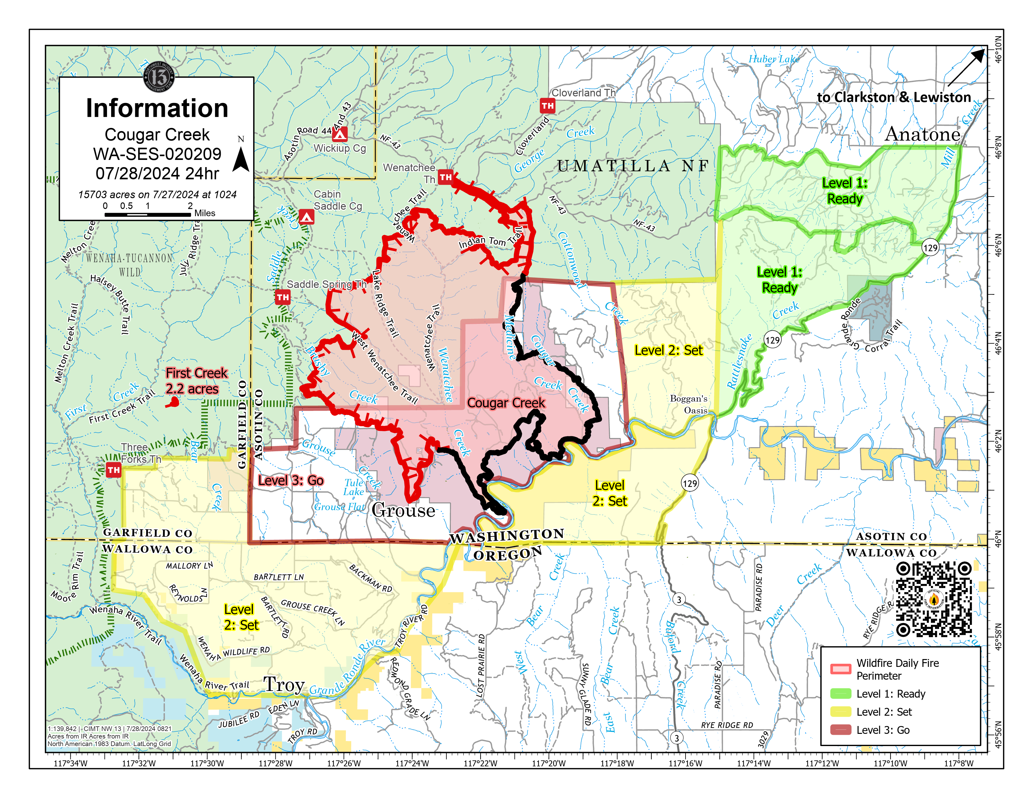
Cougar Creek Fire Update 07 28 2024
Related Incident: Cougar Creek Fire
Publication Type: News
Cougar Creek Fire Update for Sunday July 28, 2024
CURRENT STATUS:
The new lightning ignition in the Temporary Flight Restriction from yesterday, now called the First Creek Fire, was met with rappellers who responded to this new start approximately three miles west of the Cougar Creek Fire. The First Creek Fire is burning mid-way up the ridge, and its growth potential could be influenced by terrain-driven winds throughout the day. Another squad of rappellers was deployed yesterday to assist with operations, while helicopters provided water drops in support.
There was limited fire growth in the north and northeast yesterday, as well as in the south near Grouse Flats. Today, the Cougar Creek Fire will see an increase in fire activity as the day progresses due to winds aligning with topography. Indirect line construction is underway in the west, from Grouse Flats to the Three Forks Trailhead. To the south, mop up operations have begun outside of Grouse Flats, with heavy equipment completing dozer lines. Ground crews are continuing their structure protection efforts. On the western flank, fire resources took advantage of reduced fire behavior and engaged the fire directly where it is effective for containment.
FIRE BEHAVIOR AND WEATHER:
Winds are expected to increase slightly from the west/southwest. This afternoon, a cold front will pass through, bringing a slight chance of thunderstorms Monday evening into Tuesday. This front will increase relative humidity levels in the area. However, hot and dry conditions will return on Wednesday.
EVACUATIONS AND CLOSURES:
Forest closure descriptions and maps are available online on the Umatilla National Forest Closure page. In Washington, evacuation notices are posted on the Asotin County Sheriff webpage and Asotin County Emergency Management Facebook page. Grande Ronde Road is closed from Troy, Oregon to Highway 129 junction in Washington. In Oregon, a level 2 evacuation is in effect for Wallowa County, including all of Grouse Flat from Bear Creek Rd north to the State boundary and the Garfield County line to Grande Ronde River.
Whisky Creek Fire Daily Update 07 28 2024
Related Incident: Whisky Creek Fire
Publication Type: News
Email: 2024.whiskycreek@firenet.gov
Incident Information Phone Line: 541-208-1743 – daily 8 a.m. to 8 p.m.
Whisky Creek Fire Facebook: https://www.facebook.com/2024WhiskyCreekFire
InciWeb: https://inciweb.wildfire.gov/incident-news/ormhf-whisky-creek-fire
Smoke Report: https://www.airnow.gov/
Whisky Creek Fire
0% Contained
891 Acres
6 miles SE of Cascade Locks, OR
Burning in scrub oak, timber and grass
Highlights
Cloud cover helped keep temperatures lower than expected in the fire area yesterday, resulting in minimal fire spread and smoke production. These conditions are expected to continue today as crews make progress on containment lines and refine contingency plans. A closure is in place on the Pacific Crest Trail (PCT) north of the junction with Indian Springs Trail to the Bridge of the Gods in Cascade Locks with a detour along the Eagle Creek Trail. Management of the fire will transition from Great Basin Complex Incident Management Team 6 to a local tri-forest Type 3 incident management team at 6 A.M. tomorrow morning.
Operations
Crews continue to prepare containment lines and clear roads and trails to the south along the Rainy-Wahtum Trail #409 from Rainy Lake to Wahtum Lake and continuing to the PCT approximately one mile to the 2017 Eagle Creek Fire burn area. Crews are clearing thick brush along roads with the assistance of masticators to create fire breaks. To the east of the fire, crews continue to strengthen a containment line along the Gorton Creek Trail #408 and identifying potential contingency lines further east.
Fire Behavior and Weather
Increasing cloud cover and humidity, paired with lower temperatures through Tuesday, are expected to minimize fire activity and smoke production. Forecasted rain Monday is not expected to impact the fire. A remote weather station (RAWS) has been set up on Mt. Defiance to assist the incident meteorologist and fire behavior analyst make informed predictions specific to the fire location.
Road and Trail Closures
The Mt. Hood National Forest and the Columbia River Gorge National Scenic Area have expanded a joint emergency closure for the fire area to include the Pacific Crest Trail and areas south of I-84. Closure information can be found at: Whisky Creek Fire Closures in Mark O. Hatfield Wilderness. Hood River County has closures in effect for Kingsley Campground, Kingsley Road, Dead Point Road, and Green Point Road viewable on their website.
Total Fire Resources Assigned
- Approx. 284 personnel, 5 hand crews, 4 water tenders, 3 dozers, 5 masticators and 2 helicopters.
Miller Peak Daily Update July 28 2024 07 28 2024
Related Incident:
Publication Type: News
KEY MESSAGE
The containment of the fire remains at 55%. Yesterday, cooler temperatures through the night and morning have allowed for crews to effectively mop-up, bolstering containment lines. A Type 3 Incident Management Team (IMT) has arrived to take over from current IMT, the new team will take control of the incident at 0600 on Tuesday.
CURRENT STATUS
Lower afternoon humidities allowed for some fire activity within the interior of the fire. An unmanned aerial system (UAS) is being used for infrared flight detection to assist in finding hotspots. On all areas of the fire’s edge, crews continue to patrol, mop-up, and secure the edge. As a protective measure, two heavy equipment containment lines constructed farther from the fire edge are close to completion. With many successes on the incident, resources are being released to other fires or home, and slower tempo allows for a smooth transition to the incoming IMT.
WEATHER AND FIRE BEHAVIOR
Yesterday, a very dry air-mass caused afternoon humidities to drop into the teens once again as westerly winds gusted up to 25 mph at times. Looking forward, westerly flow will last through Monday then a cold front swings through western Montana on Monday night into Tuesday. This front will bring some scattered rain showers and thunderstorms along with cooler temperatures. A ridge of high pressure starts to build over the region for the latter part of the work week into the weekend. This ridge will cause a warming and drying trend with less wind.
CLOSURES
Lower Miller Creek Road is closed from debris due to storm damage. A temporary flight restriction is in effect over the fire area. An area and road closure around the fire is in effect due to hazardous conditions resulting from fire activity. Stage II fire restrictions are in effect in the area. Specific closure information and maps are posted on InciWeb at https://inciweb.wildfire.gov/incident-information/mtlnf-miller-peak-fire and https://www.fs.usda.gov/alerts/lolo/alerts-notices as they are implemented.