
Level 3 Evacuations Notice for Stehekin begins 8AM July 28 2024 07 28 2024
Related Incident:
Publication Type: Announcement
Chelan County Emergency Management has issued a Level 3 evacuation notice for the community of Stehekin effective 8 a.m. Sunday July 28, 2024. The Level 3 applies to the area from just north of Moore Point through the Stehekin Valley, including the Stehekin Landing and west to High Bridge.
A Level 3 (get out now!) alerts residents to go now and evacuate immediately. A wildfire in the area poses an immediate threat to the life and safety of people in the area. For residents and property owners, we strongly advise you leave Stehekin. In an emerging situation, we cannot guarantee that emergency responders will be able to reach you if you need help.
Evacuee transport down lake is available daily at 10:40 a.m. and 12:30 p.m. (This is an update.) We will update departure times if necessary. Shuttle service to the landing will run one hour before boat departure times.
Areas of refuge, with shuttle service, have been established at the Stehekin Ranch, airfield, Buckner Orchard and Stehekin bakery. Parking is at the airfield, a change from Friday’s community meeting. Please park on the edges of the airfield.
The American Red Cross will establish a shelter for evacuees if needed. It would be opened at the Chelan community gym, 317 E. Johnson St. Upon docking in Chelan, evacuees would be transported to the community gym by Link Transit buses, if needed.
With a Level 3, all nonessential employees with fire teams will be evacuated. EM and the Chelan County Sheriff’s Office are staged in Stehekin.
Smoke Outlook Eastern Oregon July 27 2024 07 28 2024
Related Incident: Lone Rock Fire
Publication Type: News
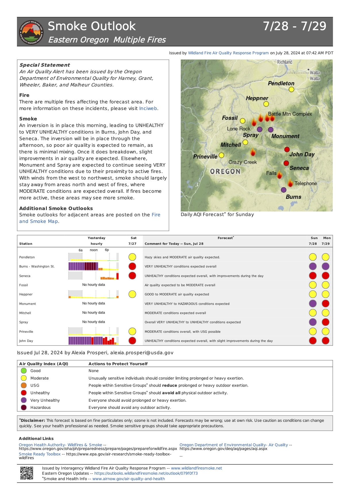
Smoke Outlook 7/28 - 7/29 Eastern Oregon
Special Statement
An Air Quality Alert has been issued by the Oregon Department of Environmental Quality for Harney, Grant, Wheeler, Baker, and Malheur Counties.
Fire
There are multiple fires affecting the forecast area. For more information on these incidents, please visit Inciweb.
Smoke
An inversion is in place this morning, leading to UNHEALTHY to VERY UNHEALTHY conditions in Burns, John Day, and Seneca. The inversion will be in place through the
afternoon, so poor air quality is expected to remain, as there is minimal mixing. Once it does breakdown, slight improvements in air quality are expected. Elsewhere, Monument and Spray are expected to continue seeing VERY UNHEALTHY conditions due to their proximity to active fires. With winds from the west to northwest, smoke should largely stay away from areas north and west of fires, where MODERATE conditions are expected overall. If fires become more active, these areas may see more smoke.
Additional Smoke Outlooks
Smoke outlooks for adjacent areas are posted on the Fire and Smoke Map.
Updates to Swawilla Fire Evacuations July 27 2024 730pm 07 27 2024
Related Incident: Swawilla Fire
Publication Type: Announcement
The evacuation areas for the Swawilla Fire have changed as of 7:30pm Sept. 27, 2024. Please refer to the map. Please contact the CCT EOC for evacuation questions – (509)634-7350
_page_2.jpg)
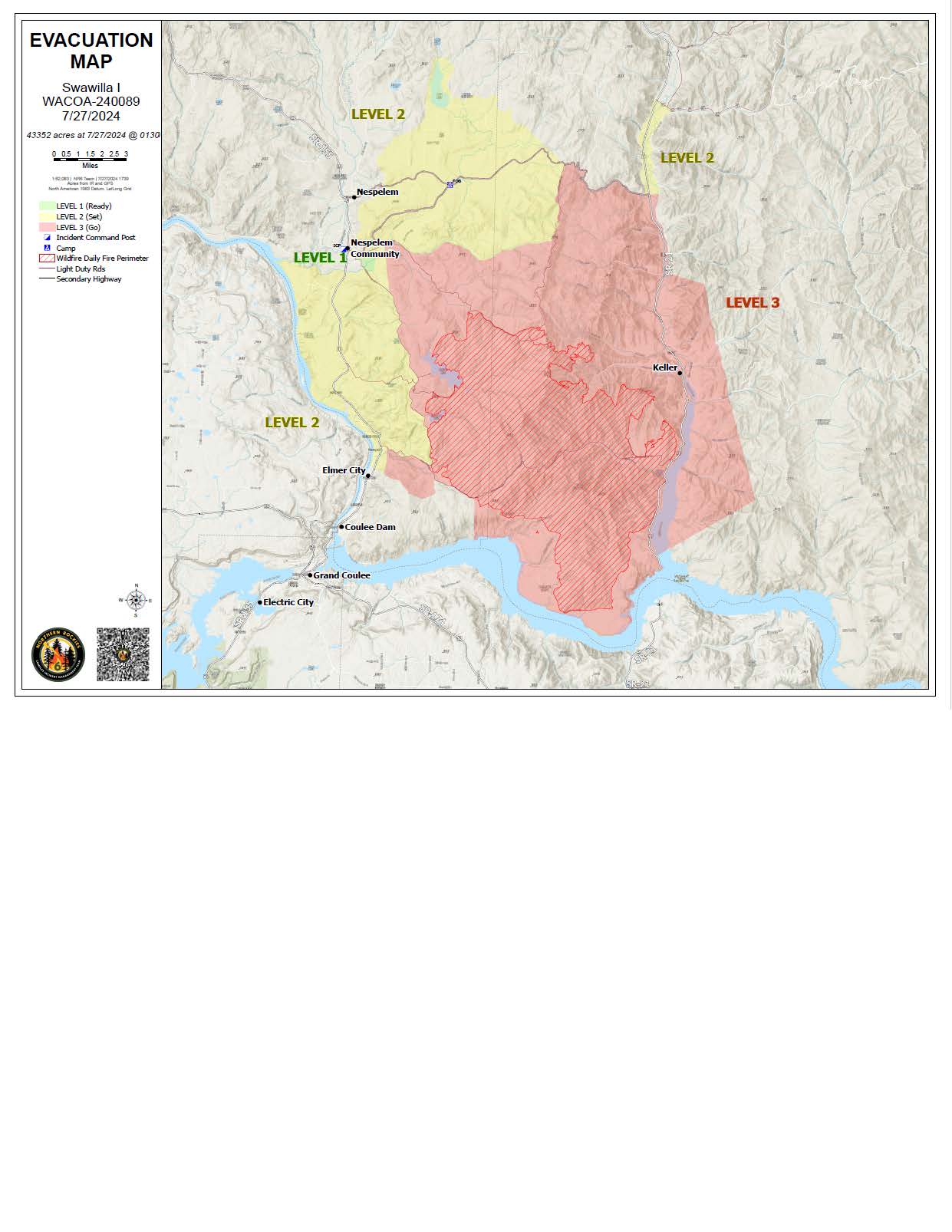
_page_1.jpg)
Updated Swawilla Fire Evacuation Maps 07 27 2024
Related Incident: Swawilla Fire
Publication Type: Announcement
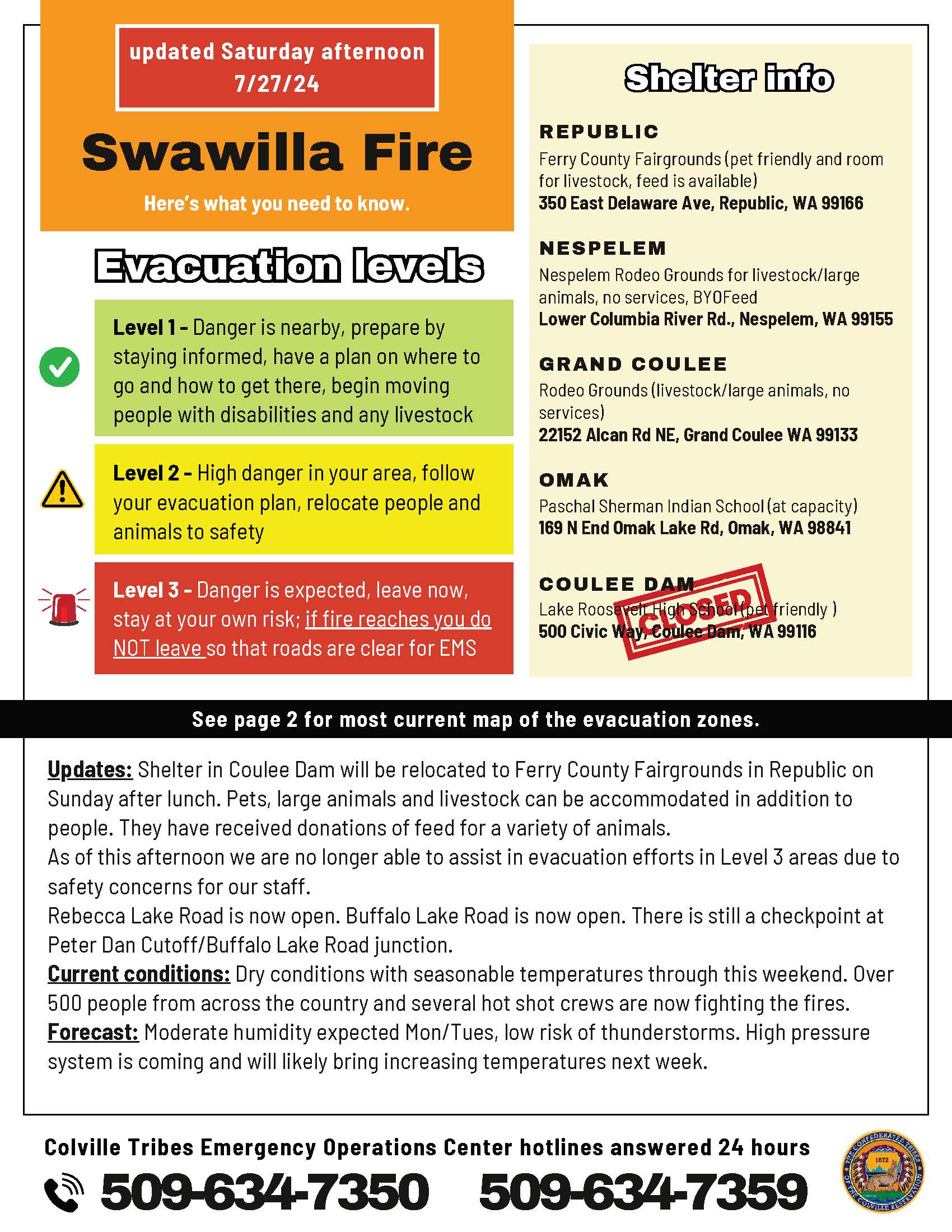
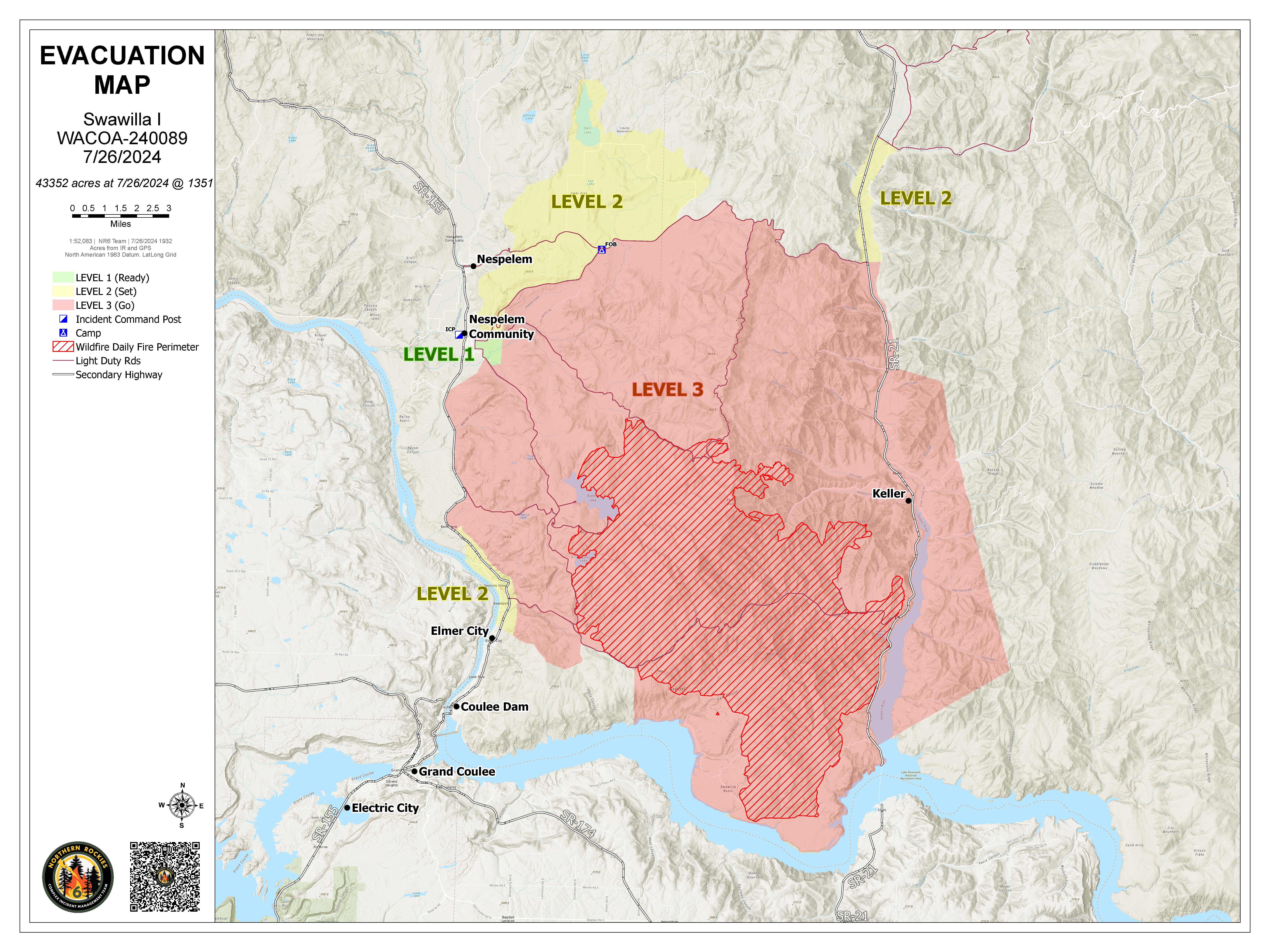
Evacuation areas for the Swawilla Fire have changed. Please see the Map for Evacuation areas. Please contact the CCT EOC for evacuation questions – (509)634-7350
Evacuations for the Bridge Creek Fire have been lifted

Cottage Grove Lane 1 Fire Update 07 27 2024
Related Incident:
Publication Type: News
Cottage Grove – Lane 1 Fires Update – Friday, July 26, 2024
Hours: 8 a.m.-8 p.m. Phone: 352-400-1218 Email: 2024.lane1@firenet.gov
Facebook: www.facebook.com/CottageGroveLane1Fires2024
The Cottage Grove – Lane 1 consists of the following fires for a total of 6760 acres: Lane 1 (1584
acres), Clark 900 (1345 acres), Quartz (935 acres), Jack Saddle (1192 acres), Puddin (323 acres),
Adam Mountain (336 acres), and Mineral (1045 acres). The Cottage Grove – Lane 1 fires are
considered 0% contained. Percent containment represents sections of fire line that pose no escape
risk without further action from firefighters. There are currently 613 personnel assigned to the
incident.
Today, fires experienced moderate intensity fire behavior. Crews on the Lane 1 fire continued to
improve and build black line. The Clark 900 crews conducted burnout operations as well as road
improvement to reduce hazard trees. Available resources and safety hazards continue to be
challenges.
Closures: Due to the wildfires, the Umpqua National Forest has issued Forest Order No. 06-15-24-03 and
Forest Order No. 06-15-02-24-01 that can be found at: https://www.fs.usda.gov/alerts/umpqua/alertsnotices
The Bureau of Land Management has issued the following emergency closure for Lane County:
https://blm.gov/announcement/bureau-land-management-issues-emergency-fire-closure-lanecounty
The following County roads are closed except to owners of private lands accessed from these
roads: Brice Creek Road east of Umpqua National Forest Boundary, all of Sharps Creek Road.
Evacuations: A “Level 1” Evacuation notice has been issued by the Lane County Sherriff’s
Department for areas east of Disston starting at Brice Creek Road milepost 0.7 and following
Brice Creek Road south. An evacuation map is available at: www.LaneCountyOR.gov/Lane1Fire
Temporary Flight Restriction (TFR): A “TFR” is in place at an altitude from the surface up to
and including 8500 feet, daily (24 hours) until further notice. Complete information is available at
https://tfr.faa.gov/save_pages/detail_4_4814.html . Flying a drone near or around a wildfire
compromises the safety of pilots and interferes with firefighting efforts.
For further information visit the Inciweb links for each Cottage Grove-Lane 1 fires below:
Lane 1: https://inciweb.wildfire.gov/incident-information/or77s-Cottage-Grove-lane-1
Clark 900: https://inciweb.wildfire.gov/incident-information/or770s-clark-900
Quartz: https://inciweb.wildfire.gov/incident-information/orupf-quartz
Jack Saddle: https://inciweb.wildfire.gov/incident-information/orupf-jack-saddle
Adam Mountain: https://inciweb.wildfire.gov/incident-information/orupf-adam-mountain
Mineral: https://inciweb.wildfire.gov/incident-information/orupf-mineral
Settings - change map background and toggle additional layers
Filter - control incident types displayed on map.
Zoom to your location
Reset map zoom and position
Could not determine your location.
Show Legend
 Wildfire
 Prescribed Fire
 Burned Area
Response
Burned Area
Response Other
Other
Boulder Fire
Unit Information
Incident Contacts
Cottage Grave Lane 1 Fires07 27 2024
Related Incident: Quartz Fire
Publication Type: News
Cottage Grove – Lane 1 Fires Update – Friday, July 26, 2024
Hours: 8 a.m.-8 p.m. Phone: 352-400-1218 Email: 2024.lane1@firenet.gov
Facebook: www.facebook.com/CottageGroveLane1Fires2024
The Cottage Grove – Lane 1 consists of the following fires for a total of 6760 acres: Lane 1 (1584
acres), Clark 900 (1345 acres), Quartz (935 acres), Jack Saddle (1192 acres), Puddin (323 acres),
Adam Mountain (336 acres), and Mineral (1045 acres). The Cottage Grove – Lane 1 fires are
considered 0% contained. Percent containment represents sections of fire line that pose no escape
risk without further action from firefighters. There are currently 613 personnel assigned to the
incident.
Today, fires experienced moderate intensity fire behavior. Crews on the Lane 1 fire continued to
improve and build black line. The Clark 900 crews conducted burnout operations as well as road
improvement to reduce hazard trees. Available resources and safety hazards continue to be
challenges.
Closures: Due to the wildfires, the Umpqua National Forest has issued Forest Order No. 06-15-24-03 and
Forest Order No. 06-15-02-24-01 that can be found at: https://www.fs.usda.gov/alerts/umpqua/alertsnotices
The Bureau of Land Management has issued the following emergency closure for Lane County:
https://blm.gov/announcement/bureau-land-management-issues-emergency-fire-closure-lanecounty
The following County roads are closed except to owners of private lands accessed from these
roads: Brice Creek Road east of Umpqua National Forest Boundary, all of Sharps Creek Road.
Evacuations: A “Level 1” Evacuation notice has been issued by the Lane County Sherriff’s
Department for areas east of Disston starting at Brice Creek Road milepost 0.7 and following
Brice Creek Road south. An evacuation map is available at: www.LaneCountyOR.gov/Lane1Fire
Temporary Flight Restriction (TFR): A “TFR” is in place at an altitude from the surface up to
and including 8500 feet, daily (24 hours) until further notice. Complete information is available at
https://tfr.faa.gov/save_pages/detail_4_4814.html . Flying a drone near or around a wildfire
compromises the safety of pilots and interferes with firefighting efforts.
For further information visit the Inciweb links for each Cottage Grove-Lane 1 fires below:
Lane 1: https://inciweb.wildfire.gov/incident-information/or77s-Cottage-Grove-lane-1
Clark 900: https://inciweb.wildfire.gov/incident-information/or770s-clark-900
Quartz: https://inciweb.wildfire.gov/incident-information/orupf-quartz
Jack Saddle: https://inciweb.wildfire.gov/incident-information/orupf-jack-saddle
Adam Mountain: https://inciweb.wildfire.gov/incident-information/orupf-adam-mountain
Mineral: https://inciweb.wildfire.gov/incident-information/orupf-mineral
Cottage Grove Lane 1 Fire Update 07 27 2024
Related Incident: Lane 1 Fire
Publication Type: News
Cottage Grove – Lane 1 Fires Update – Friday, July 26, 2024
Hours: 8 a.m.-8 p.m. Phone: 352-400-1218 Email: 2024.lane1@firenet.gov
Facebook: www.facebook.com/CottageGroveLane1Fires2024
The Cottage Grove – Lane 1 consists of the following fires for a total of 6760 acres: Lane 1 (1584
acres), Clark 900 (1345 acres), Quartz (935 acres), Jack Saddle (1192 acres), Puddin (323 acres),
Adam Mountain (336 acres), and Mineral (1045 acres). The Cottage Grove – Lane 1 fires are
considered 0% contained. Percent containment represents sections of fire line that pose no escape
risk without further action from firefighters. There are currently 613 personnel assigned to the
incident.
Today, fires experienced moderate intensity fire behavior. Crews on the Lane 1 fire continued to
improve and build black line. The Clark 900 crews conducted burnout operations as well as road
improvement to reduce hazard trees. Available resources and safety hazards continue to be
challenges.
Closures: Due to the wildfires, the Umpqua National Forest has issued Forest Order No. 06-15-24-03 and
Forest Order No. 06-15-02-24-01 that can be found at: https://www.fs.usda.gov/alerts/umpqua/alertsnotices
The Bureau of Land Management has issued the following emergency closure for Lane County:
https://blm.gov/announcement/bureau-land-management-issues-emergency-fire-closure-lanecounty
The following County roads are closed except to owners of private lands accessed from these
roads: Brice Creek Road east of Umpqua National Forest Boundary, all of Sharps Creek Road.
Evacuations: A “Level 1” Evacuation notice has been issued by the Lane County Sherriff’s
Department for areas east of Disston starting at Brice Creek Road milepost 0.7 and following
Brice Creek Road south. An evacuation map is available at: www.LaneCountyOR.gov/Lane1Fire
Temporary Flight Restriction (TFR): A “TFR” is in place at an altitude from the surface up to
and including 8500 feet, daily (24 hours) until further notice. Complete information is available at
https://tfr.faa.gov/save_pages/detail_4_4814.html . Flying a drone near or around a wildfire
compromises the safety of pilots and interferes with firefighting efforts.
For further information visit the Inciweb links for each Cottage Grove-Lane 1 fires below:
Lane 1: https://inciweb.wildfire.gov/incident-information/or77s-Cottage-Grove-lane-1
Clark 900: https://inciweb.wildfire.gov/incident-information/or770s-clark-900
Quartz: https://inciweb.wildfire.gov/incident-information/orupf-quartz
Jack Saddle: https://inciweb.wildfire.gov/incident-information/orupf-jack-saddle
Adam Mountain: https://inciweb.wildfire.gov/incident-information/orupf-adam-mountain
Mineral: https://inciweb.wildfire.gov/incident-information/orupf-mineral
Closure Order Mt Hood NF and Columbia River Gorge NSA FOREST ORDER NO 0606062407 07 27 2024
Related Incident: Whisky Creek Fire
Publication Type: Closures
UNITED STATES DEPARTMENT OF AGRICULTURE FOREST SERVICE
Columbia River Gorge National Scenic Area and Mt. Hood National Forest, Hood River Ranger District
FOREST ORDER NO. 06-06-06-24-07
Whisky Creek Fire Closure Pursuant to 16 USC § 551 and 36 CFR 261.50 (a) and (b), the following acts are prohibited on the Columbia River Gorge National Scenic Area (CRGNSA), and the Hood River Ranger District of the Mt. Hood National Forest as shown on the attached map (Exhibit A). These prohibitions will become effective July 2 , 2024, and will remain in effect until November 30, 2024, or until rescinded.
1. Going into or being upon an area closed for the protection of public health or safety. (36 CFR261.53(e))
2. Being on a road. (36 CFR § 261.54(e))
3. Being on a trail. (36 CFR § 261.55(a))
CLOSURE AREA DESCRIPTION: As depicted on “Exhibit A” all National Forest System lands, roads and trails administered by the Columbia River Gorge National Scenic Area and Mt. Hood National Forest, Hood River Ranger District within the following area: The Whisky Creek fire closure area boundary is located on National Forest System lands inside the Mark O. Hatfield Wilderness boundary east of the Eagle Creek Trail #440 and east of the Indian Springs Trail #435, in the Columbia River Gorge National Scenic Area and Mt. Hood National Forest. It also includes Forest Service Lands just east of the Mark O. Hatfield Wilderness and west of Flume Creek. It extends north of the Mark O. Hatfield Wilderness to all Forest Service lands just south of the State Trail.
The following areas currently remain open; Wyeth Campground and the Gorge #400 trail connecting the Eagle Creek Trail #440 to the Bridge of the Gods Trailhead, allowing access for Pacific Crest Trail hikers.
Additionally, the following Forest Service System roads and trails are closed:
Closed Roads within the Closure Area Forest Service Road 1000102 Forest Service Road 1000104 Forest Service Road 1002000 Forest Service Road 1004000 Forest Service Road 1310000 Forest Service Road 1310640 Forest Service Road 1310641 Forest Service Road 1310660 Forest Service Road 1310661 Forest Service Road 1310662 Forest Service Road 1310664 Forest Service Road 1310669 Forest Service Road 1311000 Forest Service Road 1400030 Forest Service Road 1400032 Forest Service Road 1400034 Forest Service Road 1400036 Forest Service Road 1400038 Forest Service Road 1403000 Forest Service Road 1403007 Forest Service Road 1430000 Forest Service Road 2810000 Forest Service Road 2810630 Forest Service Road 2810650 Forest Service Road 2820000 Forest Service Road 2820011 Forest Service Road 2820013 Forest Service Road 2820622 Forest Service Road 2820631 Forest Service Road 2820632 Forest Service Road 2820633 Forest Service Road 2820634 Forest Service Road 2820635 Forest Service Road 2820636 Forest Service Road 2820650 Forest Service Road 2820651 Forest Service Road 2820660 Forest Service Road 2820661 Forest Service Road 2820662 Forest Service Road 2820663 Forest Service Road 2820670 Forest Service Road 2820685 Forest Service Road 2821000 Forest Service Road 2821620 Forest Service Road 2821621 Forest Service Road 2821630 Forest Service Road 2821640
Closed Trails within the Closure Area Anthill Trail #406B Bear Lake Trail #413A Benson-Ruckel Trail #405A Benson Spur Trail #405C Casey Creek Trail #476 Chinidere Cutoff Trail #405M Chinidere Mountain Trail #445 Deadwood Trail #422 Eagle-Benson Trail #434 Eagle Creek Trail #440 east of its junction with Indian Springs Trail #435 east to its junction with Pacific Crest Trail #2000 Gorge Trail #400, east of its junction with the Pacific Crest Trail #2000 east to its junction with Wyeth Trail #411 Gorton Creek Trail #408 Green Point Ridge Trail #418 Herman Bridge Trail #406E Herman Creek Trail #406 Herman Cutoff Trail #410 Mitchell Point Trail #417 Mt. Defiance Trail #413 Mt. Defiance Tie Trail #413B Mud Lake Trail #406A Nick Eaton Trail #447 North Lake Trail #423 Pacific Crest Trail #2000 north of its junction with Indian Springs Trail #435 north to its junctionat Bridge of the Gods Trailhead Plateau Cutoff Trail #412 Rainy Lake Trail #423A Rainy-Kingsley Trail #409B Rainy-Wahtum Trail #409 Ridge Cutoff Trail #437 Ruckel Creek Trail #405 Starvation Ridge Trail #414 Starvation Ridge Cut-Off Trail #414B Wahtum Express Trail #406H Wahtum Switchback Trail #407 Warren Lake Trail #417A West Benson Way Trail #405B Wyeth Trail #411
Closed Recreation Sites within the Closure Area Black Lake Campground & Trailhead Herman Creek Campground & Trailhead Indian Springs/PCT North Trailhead Mt. Defiance South Trailhead Rainy Lake Campground & Trailhead Wahtum Lake Campground & Trailhead Warren Lake Trailhead
EXEMPTIONS: Pursuant to Title 36 CFR 261.50(e), the following persons are exempt from this order:
1. Any person with a permit specifically authorizing the otherwise prohibited act or omission.
2. Any Federal, State, or local official or member of an organized rescue or firefighting force in theperformance of an official duty.
3. Owners or lessees of land within the closed area.
These prohibitions are in addition to the general prohibitions in 36 CFR part 261, subpart A. Violations of these Prohibitions are punishable by a fine of not more than $5,000 for an individual and $10,000 for an organization or imprisonment for not more than six (6) months, or both. [16 USC § 551, 18 USC § 3571 ]. These prohibitions are in addition to the general prohibitions in 36 CFR part 261, subpart A.
PURPOSE: The closure is necessary to provide protection for forest users, firefighting personnel, and natural resources from the current Whisky Creek Fire.
Executed in Hood River, Oregon and Sandy, Oregon this 26 day of July, 2024.
DONNA MICKLEY Forest Supervisor Columbia River Gorge National Scenic Area
META LOFTSGAARDEN Forest Supervisor Mt. Hood National Forest