
2024 SQF Lightning Daily Incident Update 07 28 2024
Related Incident: 2024 SQF LightningBorel Fire
Publication Type: News
Trout Fire: 23,369 acres - 25% containment
Long Fire: 9,204 acres - 35% containment
Borel Fire: 38,446 acres - 0% containment
Total Personnel: 1,059
Current Situation: Under red flag weather conditions, the Borel Fire has burned over 38,000 acres in less than four days. Firefighters are actively engaging the fire using both direct and indirect tactics, while law enforcement continues evacuation efforts as the fire moves eastward. Ensuring the safety of residents and protecting property remain top priorities. Evacuation warnings and orders enhance safety for residents and allow emergency personnel to concentrate on controlling the fire. Residents can check the status of their zone using Genasys Protect's interactive map at tinyurl.com/jcdv55f9. As of Sunday morning, fire management has transitioned to a unified command led by the California Interagency Incident Management Team (CIIMT) 11 and the Kern County Fire Department.
Trout Fire: Fire growth was minimal on Sunday despite consistent warm, dry, and windy conditions, allowing crews to make progress in suppressing hotspots along the fire’s edge. On the southern perimeter, crews set up camp near the fireline in the Domeland Wilderness to extinguish lingering areas of heat and construct fireline with hand tools from Sirretta Pass toward Smith Meadow.
Long Fire: Fire activity remains minimal, consisting primarily of creeping and smoldering flames. Some unburned vegetation in the fire’s interior may continue to produce smoke, but crews report no heat sources threatening existing containment lines. Firefighters continue to make progress constructing handlines southwestward from the fire’s northeast side near the Pacific Crest Trail toward Palome Creek.
Borel Fire: The Borel Fire has slightly slowed its progression due to a change in fuel complexion as vegetation goes from dry grass to green brush. The fire is spreading eastward towards the ridgeline of Libel peak. Its southward edge sits west of Walker Basin and south eastward toward Thompson Canyon. Aerial resources, including helicopters and air tankers, are being utilized to support ground crews in slowing the fire's progression. Firefighters are focusing on protecting structures and establishing containment lines around the most active fire fronts. Today, the fire behavior is expected to be, once again, very extreme under long-term red-flag-warning weather conditions.
Weather & Air Quality: A Red Flag Warning is in effect through 11 p.m. Sunday for low relative humidity and elevated winds. Fire behavior on new and existing fires is expected to be extreme. Hot, dry conditions are expected today with wind gusts up to 35 mph possible. Westerly winds will remain elevated on ridgetops throughout Sunday night. A daily smoke outlook is produced for communities affected by wildfire smoke: tinyurl.com/452x2uzr.
Sequoia National Forest & BLM Closures & Restrictions: Sequoia National Forest lands, roads, trails, and recreation sites around the Trout and Long Fires are temporarily closed under Forest Order No. 0513-24-12. Lands, roads, trails, and recreation sites around the Borel Fire are closed under Forest Order No. 0513-24-14. Fire restrictions are in effect under Forest Order No. 0513-24-10. All orders, maps, and accompanying appendices can be found on the Forest’s website: tinyurl.com/2en2d36k. The Bureau of Land Management’s Bakersfield Field Office has temporarily closed Long Valley Campground, Chimney Creek Campground, and portions of the Pacific Crest Trail. View the emergency closure order here: tinyurl.com/4mprcb9b. The PCT is closed between Hwy 178 at Walker Pass (mile 653) and the South Fork of the Kern River bridge (mile 717.7).
Evacuation Center: Residents under an evacuation warning or order can go to the Tehachapi Education Center (126 S. Snyder Ave., Tehachapi). Animal services will assist with sheltering companion animals at the center.
Large-Animal Assistance: The rodeo grounds in Kernville (467 Scodie Ave., Kernville) is available for residents who need to move large animals or livestock. For more information, contact Orion, Kernville Chamber of Commerce, 661-340-0026.
Road Closures: State Route 178 is closed from 4.1 mi east of the junction of SR 184 to Democrat Springs. View the interactive Caltrans map for the most current road closure information: quickmap.dot.ca.gov/. Portions of Caliente Bodfish Road are also closed. Visit the Kern County Public Works Department website for the most up to date information on county road closures (tinyurl.com/z6crvp6t).
Evacuations: Everyone in areas of active fires should “Know Your Zone.” Go to genasys Protect (tinyurl.com/jcdv55f9) to identify the zone you reside in.
- Kern County has multiple evacuation orders and warnings in effect due to the Borel Fire. The following zones are under an evacuation order: KRN-403-A, KRN-403B, KRN-734, KRN-735, KRN-736, KRN-737, KRN-738, KRN-739, KRN-740, KRN-741, KRN-742, KRN-743, KRN-747-A, KRN747-B and KRN-748.
- The following zones are under an evacuation warning: KRN- 729, KRN-730, KRN-731, KRN-732, KRN-733, KRN-749, KRN-750 and KRN-752
- Tulare County has evacuation warnings and advisories in effect due to the Trout and Long Fires. The following zones are under an evacuation warning: TLC-E274-B and TLC-E261-B. The following zones are under an evacuation advisory: TLC-E297-A, TLC-E250, TLC-E274-A, and TLC-E261-A
Falls and Telephone Fires Update 07 28 2024
Related Incident: Falls FireTelephone Fire
Publication Type: News
Falls and Telephone Fires Update for July 28, 2024
Falls Fire Quick Facts:
Size: 142,307 Start Date: July 10, 2024 Location: 13 Miles NW of Burns, OR
Containment: 57% Total Personnel: 1,545 Cause: Human-caused, under investigation
Structures Triaged: Residences: 386; Commercial: 119 Outbuildings: 760
Resources Assigned: 43 hand crews, 74 engines, 23 bulldozers, 33 water tenders
Aerial resources available to the fire: 2 Type 1 Helicopters assigned
Telephone Fire Quick Facts:
Size: 22,429 Start Date: July 22, 2024 Location: 12 miles NE of Burns, OR
Containment: 0%. Total Personnel: Staffed by Falls Fire personnel Cause: Lightning/Natural
Sand Fire Quick Facts:
Size: 4,204 Start Date: July 25, 2024 Location: 17 miles SW of Seneca, OR
Containment: 0% Total Personnel: Staffed by Falls Fire personnel Cause: Undetermined
New Fire Activity Quick Facts:
Whiskey Mountain: 3,402 acres; Cow Creek: 86 acres; Parasol: 485 acres; Poison: 182
Community Meetings Scheduled:
Sunday, July 28 at 3 pm, at the Seneca City Hall
Monday, July 29 at 7 pm, at the Chamber of Commerce in Burns
Both meetings will share updates on the Falls, Telephone, and other fires in the area.
Fire Summary:
Overall, acreage gains on all fires yesterday were much more moderate than in the prior few days.
Falls Fire: On Saturday, there was minimal fire activity on the fire and the southern portion reported no growth.
To the west, crews utilized roads to prep for containment line around the Whiskey Fire and conducted small firing operations to secure the road system contingency lines. Westerly winds were beneficial to the Whiskey Fire for tactical firing operations, pushing the fire back into the Falls Fire burned area. Portions of handline were being tied into the fire perimeter on Whiskey Mountain. The northwest corner of the fire remained quiet and winds were in the favor of firefighters working direct on the fire’s edge. Wildland resources on the northeast portion of the fire, in the Myrtle Creek area, continued to face challenging conditions due to terrain. The remainder of the fire experienced minimal fire activity. Today, crews will continue to monitor and patrol on the south end of the fire and repurpose some resources to other more active areas. To the west, work will progress fire near Whiskey Mountain as conditions allow. Crews are using hoselays along dozer lines to connect the Falls Fire to the Sand Fire.
Sand Fire: On the northern edge of Falls, crews took advantage of favorable winds at the Sand Fire and conducted firing operations to secure fireline. Firing operations remove unburned pockets of vegetation between unburned areas and constructed firelines. The fire is currently near the 3160 road. Turning the corner on the west side of the fire, dozers are being used and firefighters are going as direct as possible. Crews are also using existing road systems to develop containment lines.
Parasol and Poison Fires: Poison and Parasol experienced moderate fire behavior. Crews scouted for indirect attack opportunities. While the Parasol Fire experienced small growth on Saturday, crews were able to secure and improve line all the way around the fire. The fire sits at 485 acres as of Sunday. Yesterday, crews continued to complete line around the Poison Fire and set-up pumps and hoselays. This fire is in tricky terrain which is slowing suppression progress.
Telephone Fire: On Saturday, Telephone Fire remained a top priority area and weather conditions continued to be challenging. Wind-driven fire continued to run, torch and spot in the east and southeast portion of the fire area, near Rattlesnake Rd. Crews encountered strong winds as they worked to engage a new spot fire off the eastern edge of Telephone near FSR 711. Additional crews and air resources responded. The incident utilized 8 hand crews, 10 engines and 6 dozers. OSFM resources provided structural protection. On the fire’s west side, crews have strong containment from the northern portion of the 28 road to the southern part of the fire at the 28 road near Cow Creek. Firing operations will continue in order to remove burnable vegetation on the fire’s edge, between the active fire and the direct fireline. The fire will remain a priority as crews work direct to get a foothold and increase containment. Today, crews are working to secure a slopover across the 28 road and extending indirect line and using road systems, dozer line, existing fuel treatment areas and previous burn areas as well as air support to connect to the Upper Pine Fire area, being mindful of cultural resources in the area.
Ritter Fire: Yesterday, the Alaska Incident Management Team assumed command of the Ritter Fire, located approximately 30 miles east of Burns (just east of the Stinking Water access road) and west of Warm Springs Dam. Two hotshot crews, elite firefighters that excel in challenging terrain, worked on the southeast corner to establish containment line in advance of expected winds. This part of the fire area remains difficult to access due to steep ravines, channeled winds and rugged topography. Today’s plan is to secure line already created in the southeast corner of the fire and work on a green island of unburned vegetation of potential concern.
With the significant number of new fire starts in the area at this time, firefighters remain vigilant and focused on initial attack (IA) and remain ready to respond to any new threats.
This morning, Oregon State Fire Marshal (OSFM) resources are demobilizing from the Falls and Telephone Fires. OSFM crews have completed structural triage, surface prep, full prep and point protection on structures throughout the incident area. These efforts, in conjunction with the progress made by wildland resources, have helped mitigate the risk to structures.
Wildland resources will be assuming responsibility for ongoing structural protection, and local resources remain available to assist if needed. OSFM resources are available to return if there is an imminent threat to structures that exceeds the capabilities of existing resources.
OSFM would like to extend appreciation to the local communities and agencies for their ongoing support and cooperation throughout this challenging time.
Weather: Smoky conditions will persist Sunday and may worsen throughout the day. A deep inversion layer will take time to lift. Additional smoke from other fires burning throughout the west will impact the area. Temperatures started out much cooler Sunday morning in the fire area and will climb to the mid-80’s by afternoon. Diurnal northwesterly winds will transition to the west, with potential wind gusts between 20-25 mph again today. A potential dry cold front is possible on Monday night.
Evacuations: Evacuations remain in place in both Grant and Harney Counties and have expanded due to the Telephone, Parasol and Poison Fires. For the most accurate evacuation information, please visit the Harney County Sheriff’s evacuation map here: https://tinyurl.com/3zst4sjy, or the Grant County Emergency Management Facebook page at: https://www.facebook.com/profile.php?id=100068819321423.
Closures: Due to active wildfires compounded by extremely unfavorable weather conditions, limited firefighting resources and County Resources, Malheur National Forest officials have temporarily closed lands within the Malheur National Forest.
Investigation: U.S. Forest Service fire investigators are seeking the public’s assistance with any tips or information pertinent to the start of the Falls Fire on the Malheur National Forest. Please submit any information that could assist fire investigation efforts to SM.FS.R6TipHotLine@usda.gov.
Facebook: https://www.facebook.com/p/Falls-Fire-2024-61562126623985/
Falls Fire InciWeb: https://inciweb.wildfire.gov/incident-information/ormaf-falls-fire
Telephone Fire InciWeb: https://inciweb.wildfire.gov/incident-information/ormaf-telephone-fire
Fire Information Line: 541-208-4370, staffed 8 a.m. to 8 p.m.
Email: 2024.Falls@firenet.gov
Harney County non-emergency evacuation questions: 541-589-5579
Air quality questions: 541-573-2271
Smoke Outlooks: https://outlooks.airfire.org/outlook
Updates to Swawilla Fire Evacuations July 28 2024 07 28 2024
Related Incident: Swawilla Fire
Publication Type: Announcement
Sunday, July 28, 2024 The evacuation areas for the Swawilla Fire have changed. Please refer to the map. Please contact the Confederated Colville Tribes Emergency Operations Cetner for evacuation questions – (509) 634-7350
Diamond Complex and Middle Fork Daily Update 07 28 2024
Related Incident: Middle Fork Fire
Publication Type: News
July 28, 2024
Northwest Team 7 is currently managing the Diamond Complex, estimated at 4,990 acres and 7% contained, consisting of 26 fires. The team has assumed command of the Middle Fork, 659 acres and 1% contained, within Crater Lake National Park. The park remains open. There are fire personnel in the area, so visitors should use caution when traveling within the park.
Currently there are 27 fires and 620 personnel assigned to the two incidents.
Crews are engaged in a full suppression strategy utilizing direct attack on the fires’ edge where access and firefighter safety allow and implement indirect strategies using constructed control lines or natural barriers where direct attack cannot be done safely. Pacific Power and Light infrastructure within the complex continue to be a top priority for protection as crews attack fires threatening those resources.
The Trail fire, east of Hwy 138 on the west slope of Mt. Thielsen, is 826 acres and 25% contained. Crews continue to strengthen containment lines on the north and south flanks to keep the fire within the current control lines.
The Lemolo fire, north of Lemolo Lake on Bunker Hill, is 775 acres and 0% contained. Crews have made good progress on the east flank and will continue to secure the dozer line and look for opportunities to implement control lines north of the fire to protect recreational values around Lemolo Lake.
The Pine Bench fire, north of Hwy 138 near Dry Creek, is 1,855 acres and 0% contained. The Prineville Hotshots initiated a burn out operations along the 4775 road. This tactic uses fire to fight fire by strategically burning fuels between the containment line and the fires’ edge. Crews will continue to monitor around the burn out and mop up any new spot fires that occur.
The Watson fire, north of Hwy 138 on Watson Ridge, is 232 acres and 50% contained. It has been fully lined with hand line and dozer line or hoses, and crews will work to fortify and hold these lines in today’s shift.
The Loafer fire is at 33 acres and 50% contained, crews were able to utilize a masticator, a piece of heavy equipment used to clear vegetation off existing roads. This allowed crews to gain closer access to the fire where they utilized water tenders to soak any hot spots along the edge. Today they will continue to fortify the line and identify any additional hot spots.
There are smaller clusters of fires within the complex that consist of: Pig Iron, 27 acres and 95% contained, near Pig Iron Mountain north of Hwy 138; Brodie, 109 acres and 0% contained, about 5 miles south of Hwy 138 and south of Devils Canyon; Trep, 123 acres and 0% contained, about 4 miles south of Hwy 138; Garwood, 5 acres and 95% contained, about 3 miles southwest of Mt. Bailey; Slide, 0.1 acres and 95% contained, northeast of Pine Bench; Potter, 673 acres and 0% contained, north of Hwy 138 about 2 miles southeast of Potter Mountain; Ooya, 182 acres and 0% contained, north of Hwy 138 about 1 mile northeast of Bird Point; Clearwater, 0.7 acre and 100% contained, south of Hwy 138 about 5 miles northwest of Diamond Lake; Elephant, 0.7 acres and 95% contained, 2 miles southwest of Lemolo Lake; Lost Bear, 0.1 acres and 0% contained, 2 miles south of Hwy 138; Lost, 14 acres and 0% contained, 4 miles south of Hwy 138; Sheep, 0.3 acres and 95% contained, 3 miles north of Diamond Lake; Thin, 0.6 acre and 90% contained, four miles northwest of Diamond Lake; Trap, 11 acres and 0% contained, 1 mile south of Hwy 138 near Trap Mountain; Bear Trap, 64 acres and 10% contained, 2 miles south of Hwy 138 near Bear Trap Mountain; Campwood, 17 acres and 0% contained, 2 miles south of Hwy 138; Rough, 11 acres and 0% contained, two miles south of Hwy 138; Birds, 0.1 acres and 100% contained; Wood, 21 acres and 0% contains, 2 miles south of Hwy 138, and Mowich, 0.4 acre and 75% contained, 1 mile north of Hwy 138. In addition, there are two more unnamed fires in the complex, both at 0.4 acres and 0% contained.
The Middle Fork fire is located in the northwest corner of Crater Lake National Park. Crews made excellent progress yesterday establishing a western boundary and will continue to fortify this line today. Divisions will work across the southern perimeter to create fuel breaks to stop progression toward the historic buildings and infrastructure in the park. They will continue to improve access and create fuel breaks along the Bert Creek Trail to the junction of the Bald Creek Trail.
Today, firefighters will continue direct suppression on accessible fires, and will develop specific suppression strategies for other less accessible fires to be carried out as resources become available.
Nationally and in the Pacific Northwest, fire activity is putting an extreme demand on firefighting resources. The highest priority remains public and firefighter safety and protecting infrastructure and homes.
Weather: The forecast remains in the mid to upper 70’s and will be mostly sunny today with areas of smoke. Humidity levels remain in the 20-30% range through the weekend, and are expected to increase early next week as weather pattens shift and temperatures increase by the end of the week.
Fire Behavior: Lower humidity recoveries over night will result in more active fire behavior especially along ridgetops where fuels are drier. Some short uphill runs are possible through surface fuels with potential for some single tree or group torching in the afternoon hours.
Smoke Outlook: Smoke will remain the area and may reduce visibility and hinder air operations. For the most up to date information, please visit www.fire.airnow.gov
Diamond Lake Campgrounds are open.
Starting July 27, 2024, the Administrative Closure for Diamond Lake, Thielsen View, and Broken Arrow Campgrounds has been lifted. Campgrounds will be first-come, first-serve for Saturday, July 27, and Sunday, July 28. They will go back into reservation status for Monday, July 29.
Closures and Evacuations: Umpqua National Forest has issued two closures across the forest in response to fire activity to protect public and wildland firefighter safety. Emergency Fire Closure ORDER NO. 06-15-24-03 and Emergency Fire Closure ORDER NO. 06-15-02-24-01 impact all of the Cottage Grove Ranger District, most of the Diamond Lake Ranger District, and parts of the Tiller and North Umpqua Ranger Districts. The closure orders can be found here: https://www.fs.usda.gov/alerts/umpqua/alerts-notices. Fire danger is set at Very High and Public Use Restrictions are set at Level 2: https://bit.ly/3xIZZdK.
The Douglas County Sheriff’s Office has downgraded the evacuation order for the Trail fire from a Level 2: BE SET to a Level 1: Get Ready, but the Level 3: GO NOW remains in effect for the Trail fire east of Hwy 138. The Level 2: BE SET and Level 3: GO NOW evacuations for the Lemolo fire remain in place. There is still a Level 2: BE SET for the Pine Bench Fire. For more information visit the Douglas County Sheriff’s Office website: www.dcso.com/evacuations.
Battle Mountain Complex 07 28 2024
Related Incident: Battle Mountain Complex
Publication Type: News
Firefighters continue to hold and secure more line with milder temperatures in the forecast.
Ukiah, Ore. - Firefighters with Oregon Department of Forestry Teams 1 and 3 continue to make strides across the Battle Mountain Complex fires, with more lines being built, connected and strengthened on both Zones I and II. Slight changes in weather today may test some control lines, however it will also offer opportunities for firefighters to secure areas that have been challenging. Wind direction is the biggest change; winds from the west will be present across the fires today, which may provide some natural help to firefighters, along with the potential for clearer skies for continued aircraft use.
On Zone I, firefighters had a good night overall; on the southwest side, resources were able to conduct strategic firing operations to better secure line between the fire and scattered homes in the area. Today, firefighters will mop up these areas, further strengthening line, with continued structure protection provided by Oregon State Fire Marshal (OSFM) task forces. To the northwest, much of the same work will occur. West winds in the afternoon should help naturally push fire away from the line and into the interior of the fire itself.
To the south in Zone I, firefighters continue to hold and strengthen line from Monument to the east. Firefighters will focus on further mop-up in these areas today. To the north, resources continued building line. A lot of this terrain is difficult to access and building a strong line can be challenging; however, crews have used strategic firing operations as a beneficial tool in stopping fire growth.
In Zone II, firefighters capitalized on the milder conditions and increased resources to cut-in tighter line along the northeast perimeter to save an additional 400 acres of forested land.
“This was another big win we’ve been looking for,” said ODF Team 3 Incident Commander Tyler McCarty. “We’re really proud of the firefighters and our operations staff for taking advantage of this opportunity. This will protect a lot of homes in that area, minimize acres and protect the community’s natural resources.”
On the southern head of the fire, crews carried out a burn operation, to remove unburnt vegetation and used dozers to connect into Zone I to the west to minimize new growth.
Elsewhere in Zone II, firefighters are holding and securing lines, while catching smaller fires that spotted or crossed over firelines. Crews are beginning to mop up in more areas in Zone II where lines are more secure. Mop-up operations also continue on the North Fork Owens Fire to north of the Monkey Creek Fire.
Evacuations: Level 1 (Be Ready), Level 2 (Be Set) and Level 3 (Go Now) evacuations are in effect. For updated information, visit:
• For Umatilla County, follow www.facebook.com/UmatillaCountySheriff or sign up for Umatilla County Emergency Alert System at https://member.everbridge.net/index/2590041373147145.
• For Grant County, visit the RAPTOR arcgis site or sign up for alerts at: https://member.everbridge.net/index/825462649520134.
• For Morrow County, visit https://experience.arcgis.com/experience/de78333b0d2544f7a320142174aa20ae
Public Land Closures:
The Bureau of Land Management has closed public lands along the John Day River from Kimberly to Dale, and from Kimberly to Service Creek. More information here: https://www.blm.gov/programs/public-safety-and-fire/fire-and-aviation/regional-info/oregon-washington/fire-restrictions.
The Umatilla National Forest has implemented a closure for public lands within the Heppner Ranger District and the North Fork John Day Ranger District. More information at: https://www.fs.usda.gov/detail/umatilla/news-events/?cid=FSEPRD1194462 and https://www.fs.usda.gov/detail/umatilla/alerts-notices/?cid=stelprdb5286768.
FIRE AT A GLANCE
Total Estimated Complex Size: 162,389 acres
Monkey Creek Fire: 157,905
North Fork Owens: 4,484 acres
Total Containment: 7%
Cause: Under Investigation
Estimated Cost: $18,200,000
All Resources
Hand Crews: 52
Engines: 99
Water Tenders: 41
Dozers: 20
Helicopters: 8
Total Personnel: 1,712
Courtrock Fire Morning Update 07 28 2024
Related Incident: Courtrock Fire
Publication Type: News
Firefighters continue to hold and strengthen Courtrock Fire lines
MONUMENT, Ore. – Line on the Courtrock Fire continues to be built by firefighters with the Oregon Department of Forestry Incident Management Team 1, local landowner resources, and Oregon State Fire Marshal (OSFM) structural task forces. The fire continues to push forward to the southeast, where terrain significantly limits access by vehicles. Bulldozers and other equipment are playing a heavy role in building line on this incident, and aircraft has been an added asset over the past couple of days. West winds expected today may bring even more visibility, allowing for continued use of helicopters.
Three OSFM task forces are assigned to work on the incident today, the majority stationed in the Fox Valley area. Structure protection continues to be a focus, with a collaborative effort on the ground between OSFM, landowners and the ODF John Day unit. Both engines and bulldozers are being used to protect homes.
Despite challenges in the past few days, the south and northeast lines of the Courtrock Fire are holding well, and firefighters are working to strengthen lines, which is contributing to an increase in containment.
While temperatures have been slightly cooler, vegetation remains extremely dry and primed to burn; firefighters have continuously seen increased fire activity in the afternoon, and will be monitoring conditions as the day progresses. West winds are expected to pick up around 10-15 miles per hour. Due to these conditions, fire growth may naturally occur moving east. A potential for rain is in the forecast for Monday evening, and incident meteorologists will continue to monitor this incoming system.
Due to fire activity in the area, the U.S. Forest Service has issued closures for the Malheur. Up to date information on Malheur National Forest closures can be found here: https://www.fs.usda.gov/news/malheur/news-events
Information for Zone I of the Battle Mountain Complex, including the western portion of the Monkey Creek Fire (formerly Boneyard Fire) can now be found at: www.facebook.com/battlemountaincomplex2024
Evacuations: Level 1 (Get Ready), Level 2 (Be Set) and Level 3 (Go Now) evacuations are in effect. For updated evacuation information:
- Grant County Emergency Management Office’s Facebook page, or sign up for the Grant County Emergency Alert System at https://member.everbridge.net/825462649520134/login. Morrow County Evacuation information can be found at https://experience.arcgis.com/experience/de78333b0d2544f7a320142174aa20ae
Shelters: An evacuation center has been set up at Grant Union High School (911 S Canyon Blvd., John Day, OR 97845).
Clean air and cooling centers are located in the following locations in Grant County:
- Grant County Library- cooling & clean air, Monday – Thursday 11 a.m. - 5:30 p.m.
- John Day Senior Center- cooling & clean air, Monday & Thursday 10 a.m. – 5 p.m., Tuesday 12 – 4 p.m.
- Prairie City Public Works - clean air center, Monday - Friday 12 – 7 p.m.
- Dayville Community Hall- cooling & clean air, 24/7
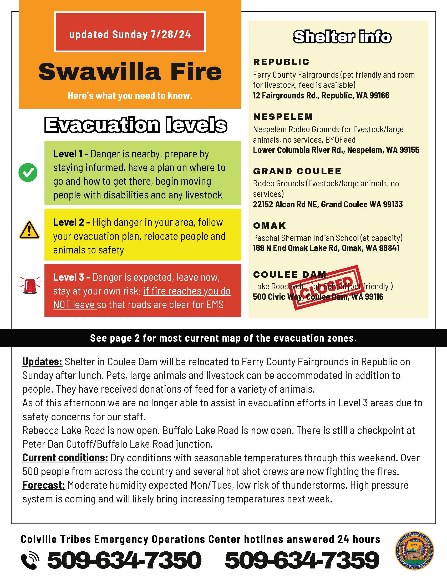
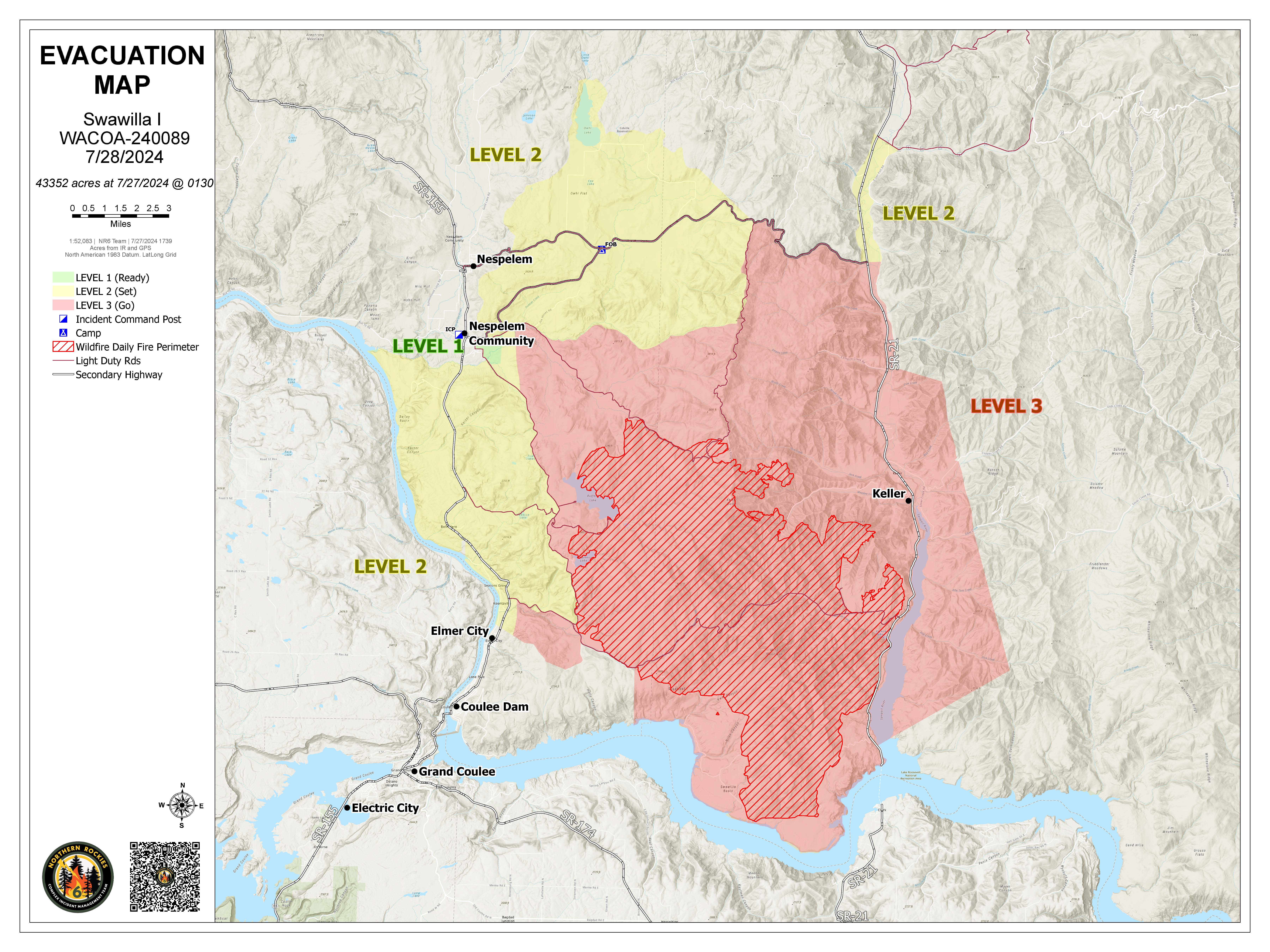
Daily Update Swawilla and Bridge Creek Fire July 28 2024 07 28 2024
Related Incident: Swawilla Fire Bridge Creek
Publication Type: News
Update for Swawilla and Bridge Creek Fires
Evacuation areas have changed. Please see the map for updated evacuation areas. Please contact the Colville Confederated Tribes EOC for evacuation questions – (509)634-7350.
The Bridge Creek Road is now open. See chart for remaining closures.
Dozers and a type 1 hotshot crew worked tirelessly yesterday to build control lines on the northern perimeter in an effort to catch the head of the fire. Primary containment lines are mainly along Jack Creek Rd with secondary dozer lines in the Empire Creek Rd corridor as a contingency plan. Burnout Operations are planned once those containment projects are finished, and weather is favorable.
Firefighters made strong gains along the western flank of the fire adding to containment efforts. Active fire behavior is still affecting Mt.Tolman, however, crews continue to put in handlines and use burnout operations to safely secure structures in the area. Strong southerly winds will affect the area later this evening with gust reaching 20 mph. However, moisture will move in and elevate relative humidity into Monday and Tuesday, assisting with firefighting efforts.
The fire remains ¾ of a mile from Jack Creek residences, and is slowly backing down the north face of the slope into greener, less dry vegetation. A dozer line has been constructed along the west side of Keller, and fire managers plan to keep fire out of the town. Air operations remain active in the northeast portion of the fire near Mt. Tolman and Meadow Creek.
Buffalo Lake Rd down to Peter Dan Rd is re-opened, and plans to re-open the remainder of Peter Dan and Manilla Rd are underway. Before the road can be safely opened, fire-weakened trees must be removed along the roadway.
The evacuation center at Roosevelt High school is closing today at noon. An evacuation center will be set up at the Republic Fairgrounds. Contact Tribal Emergency Operation Center for more details: 509-634-7350.
Bridge Creek Wildfire
The Bridge Creek Road opened yesterday after firefighters finished removing hazardous roadside trees. The 30 Mile Road remains closed where firefighters are conducting burning operations along the northern border of the fire. Resources continue to be reassigned from Bridge Creek to Swawilla Fire as containment improves. Evacuations have been lifted for residents near Bridge Creek.
Safety Message
Please slow down when driving all roads leading to or from the fires. There is a considerable amount of firefighting traffic and equipment moving slowly along roads.
We request that boaters avoid emergency firefighting aircrafts using any waterbody to acquire water to suppress fires.
Additional Information and Maps at https://inciweb.wildfire.gov/, https://www.facebook.com/CCTENV, https://www.facebook.com/CCTBroadcasts
July 28 Homestead Complex Daily Update 07 28 2024
Related Incident:
Publication Type: News
HOMESTEAD COMPLEX FIRE UPDATE
Sunday, July 28, 2024
Fire Information
Phone: 208-713-9693 (8 a.m. to 8 p.m.)
Email: 2024.homesteadcomplex@firenet.gov
Facebook: www.facebook.com/HomesteadComplexFireInfo
Inciweb: http://inciweb.wildfire.gov/incident-information/orupf-homestead-complex
Smoke Outlook: https://outlooks.airfire.org/outlook/d393fd74
Fireline Work Continues While Weather Pattern Holds
The seven fires of the Homestead Complex currently total 1,466 acres with 4% containment. Suppression tactics are being prioritized by threat to property, infrastructure, industry, and areas with the highest probability of success. There are currently 406 personnel assigned to the incident.
Fire activity is expected to be moderated by smoke and cloud cover for the next few days, with an increased potential for cloud cover on Monday and Tuesday due to a predicted storm north of the Complex area. Crews are taking advantage of moderated fire activity to make progress tying in fireline around several fires
Crews finished plumbing line south of the Salmon 33 Fire (142 acres). Resources are continuing fireline construction on the east and north flanks. On the No Man Fire (510 acres), cooperators and crews completed indirect line on the west flank and began patrolling and improving their work. On the south and east sides of the fire, resources are continuing indirect line construction utilizing the 3806 Road.
Crews plan to try to complete indirect line around the south end of Horse Heaven Creek Fire (412 acres) in the next couple days. Crews are working to complete the last mile of handline construction north of the fire, near the 920 Road. On the Bullpup Fire (131acres), masticators continue improving the 300 Road north of the fire. Resource Advisors and firefighters continue to work together to develop plans for the Fuller Lake Fire (67 acres) when resources are available.
Resources continue to prep, improve, and plumb indirect lines surrounding the Reynolds Butte Fire (170 acres) to minimize the footprint of the fire. An Unmanned Aircraft System (UAS) may be used for aerial ignition to tie the main body of the fire to the indirect fireline under favorable terms. Containment lines continue to hold on the Lost Bucket Fire (34 acres). Crews on the ground will continue to monitor the fireline for any activity.
Current forest fire restrictions and danger ratings are: Fire Danger Rating: Very High. Industrial Fire Precaution Levels (IFPLs): 2. Public Use Fire Restrictions (PURs): 2.
CLOSURES: The Bureau of Land Management (BLM), Roseburg District, has issued a closure order for portions of BLM land which border the Umpqua National Forest Emergency Fire Closure north of Steamboat. The closure order can be viewed here: https://www.blm.gov/sites/default/files/docs/2024-07/orwa-fpo-rbg-072624.pdf. Umpqua National Forest Emergency Fire Closure ORDER NO. 06-15-24-03 and ORDER NO. 06-15-02-24-01 remain in effect and can be found here: https://www.fs.usda.gov/alerts/umpqua/alerts-notices.
Pioneer Fire Update 07 28 2024
Related Incident:
Publication Type: News
Pioneer Fire Update for July 28, 2024
Incident Commander Lonnie Click
Complex Incident Management Team Northwest 3
(541) 861-5808, staffed 8 a.m. to 8 p.m. 2024.pioneer@firenet.gov
Pioneer Fire Daily Update July 28, 2024
Quick Facts
Size: 33,277 acres
Start Date: June 8, 2024
Location: 31 miles NW of Chelan, WA
Containment: 10%
Personnel: 712
Cause: Human-caused, under investigation
Resources Assigned: 11 crews, 4 helicopters, 24 engines, 27 water tenders, 18 heavy equipment
CURRENT SITUATION: The Pioneer Fire crossed the Fourmile drainage yesterday and progressed further north. This fire movement has prompted Chelan County Emergency Management to issue a Level 3 (Get out now!) evacuation notice for the community of Stehekin, from just north of Moore Point through the Stehekin Valley, effective beginning at 8 a.m. on Sunday, July 28. More information, including boat schedules and shelter information for evacuations, is available from Chelan County Emergency Management at https://t.ly/QoH9w. The evacuation level from Safety Harbor to Moore Point was reduced to a Level 2.
Firefighters, working with state mobilized structure protection group, have been working to protect the community of Stehekin. Through their coordinated efforts, hose and sprinkler systems have been installed, flammable material reduced around homes and structures, and a fireline has been constructed around the community. Firefighters yesterday worked to remove snags and continue structure protection and adding more hose lays and sprinklers, while also removing rocks and plant material above the road from the landing into the Stehekin Valley that leads to secure safe passage to the boat access point. Along the lakeshore, crews continued to patrol and mop up around structures.
Most of the recent fire activity and fire spread has been in the northwest corner of the fire, though there is some active burning in the Prince Creek drainage. Much of the perimeter along the lakeshore has been contained and along the eastern edge, the fire has not crossed the Sawtooth range. The Lone Fir drainage at the southern edge is still showing no heat. Firefighters continue to monitor the southern edge and improve contingency lines near Manson.
TODAY’S ACTIVITIES: In Stehekin, firefighters will continue improving fireline and preparations to protect homes and infrastructure. Additional f3irefighters will also be relocating from Lucerne to support strategic firing operations in Stehekin. Along the lakeshore, crews will continue patrolling, mopping, up, and conducting strategic firing around structures where needed and as conditions allow. Crews will also continue to improve roads and continency lines south of the fire and east of Manson. Firefighters are also prepared to support initial attack of any new fires.
WEATHER AND SMOKE: Warm and dry conditions are expected again today, with light winds throughout the day and gusts in the midafternoon and evening of up to 15 mph. Temperatures will be in the high 70s to low 80s. Light rain is expected over the fire on Monday. An air quality alert has been issued for Chelan County. See Current Smoke Outlook for North Central Washington (airfire.org) for more information about smoke and air quality.
EVACUATIONS: Level 1, 2 and 3 evacuation levels remain in effect around the Pioneer Fire. Please visit https://t.ly/QoH9w for more information.
FOREST CLOSURE: Current closures for the North Cascades National Park: https://www.nps.gov/noca/index.htm
The Okanogan-Wenatchee National Forest has a closure order in place for much of the fire area: Okanogan-Wenatchee National Forest - Alerts & Closures (usda.gov). Campfires are prohibited. There is a Temporary Flight Restriction (TFR) in place over the fire: https://tfr.faa.gov/save_pages/detail_4_6779.html. Unauthorized drone activity is prohibited under the TFR.
Facebook: https://www.facebook.com/profile.php?id=61560760893080
Fire Information Line: 541-861-5808, 8 AM to 8 PM
Email: 2024.pioneer@firenet.gov
Easy Fire Update 07 28 2024
Related Incident: Easy Fire
Publication Type: News
Easy Fire Update for July 28, 2024
Incident Commander Lonnie Click
Complex Incident Management Team Northwest 3
(541) 861-5808, staffed 8 a.m. to 8 p.m. 2024.pioneer@firenet.gov
Quick Facts
Size: 528 acres
Start Date: July 17, 2024
Location: 17 miles west of Mazama, WA
Containment: 0%
Personnel Assigned: 110
Cause: Lightning
Resources Assigned: 3 crews 5 engines
CURRENT SITUATION: State Route 20 remains open to through traffic. A pilot car will escort vehicles through mileposts 148-157 from 7 a.m. to 8:30 p.m. daily. Expect 30 minutes delays as firefighters continue removing trees and debris from the roadway and conduct full suppression tactics on the Easy Fire. Please do not stop or pull over between mileposts 148-157. With wildfire and firefighting operations still active, the highway may need to close again on short notice. Be sure to check https://wsdot.com/Travel/Real-time/Map/ for the latest information on State Route 20.
The south end of the Easy Fire continued to slowly burn toward the indirect fireline, however the fire remains north of the avalanche chute and the constructed fireline. Firefighters brought hoses to both sides of the Easy Fire utilizing helicopters to deliver materials near the 2004 Mebee burn scar. Due to a build up of cumulous clouds, and potential for thunderstorms, strategic firing operations were put on hold on Saturday. Crews continued to bolster indirect firelines and tested sprinkler systems on the Easy Pass Trailhead. Firefighters successfully cut out a helicopter landing spot near the Mebee Lookout Tower to conduct structure protection operations if the need arises.
TODAY’S ACTIVITIES: Crews will continue monitoring fire activity on State Route 20 and implement continuous hose lays on both sides of the Easy Fire. Pending favorable weather conditions, crews may conduct strategic firing operations on the southeast side of the Easy Fire using aircraft. Using aviation for firing operations reduces risk to firefighters on the ground working in steep terrain and can cover more ground than a human can on foot. Strategic firing operations create a more controllable slow-moving fire by reducing ground fuels, or vegetation.
The Easy Fire has a Temporary Flight Restriction in place for all aircrafts not involved in wildfire suppression operations. Do not fly a personal drone over or near the Easy Fire. Any incursions create a safety hazard to fire aircraft and require air operations to stop.
WEATHER: Temperatures today will increase slightly with highs in the mid to upper 80s. Sky weather is partly cloudy with northwest winds around 5-9 mph during the day and 9-13 mph in the evening. There is a chance of showers in the early morning resulting in small amounts of precipitation over the Easy Fire.
CLOSURES: The Okanogan-Wenatchee National Forest has closures in place for trails within the fire area: https://bit.ly/EasyFireClosures. This closure includes a portion of the Pacific Crest Trail. Campfires are prohibited. There is a Temporary Flight Restriction (TFR) in place over the fire: https://tfr.faa.gov/save_pages/detail_4_6779.html. Unauthorized drone activity is prohibited under the TFR.
EVACUATIONS: There are no evacuations in place for the Easy Fire. Anyone recreating in the area should be vigilant about being aware of surroundings and stay out of closed areas.
Facebook: https://www.facebook.com/profile.php?id=61560760893080
Fire Information Line: 541-861-5808, 8 AM to 8 PM
Email: 2024.easy@firenet.gov