
Silver King Fire Daily Update July 29 202 07 29 2024
Related Incident: Silver King Fire
Publication Type: News
Public Information Phone: (435) 310-5450 Email: 2024.silverking@firenet.gov
Agency: Fishlake National Forest – Beaver Ranger District
Location: Approximately three miles west of Marysvale, Utah
Start Date: July 05, 2024
Cause: Lightning
Acres: 18,222
Containment/Completion: 89%
Personnel: 179
**RED FLAG WARNING IN EFFECT FOR MONDAY AND TUESDAY**
The National Weather Service has extended the Red Flag Warning again for the Silver King Fire and surrounding areas until Tuesday, July 30th, 2024. Temperatures in the mid-80s, humidity as low as 6%, and winds over 25 mph may cause existing fires or new fires to spread rapidly.
During Red Flag conditions residents should avoid using machinery that can create sparks and ensure that trailer chains do not drag. Do not drop cigarettes or matches on the ground. Avoid recreational target shooting in dry grass. Follow Stage 1 Fire Restrictions that prohibit open fires of any kind except within established public facilities in improved campgrounds and picnic areas. Give firefighters room to work and abide by the Silver King Fire Forest Closure Order (see closure details at: https://www.fs.usda.gov/alerts/fishlake/alerts-notices).
The smoke and activity seen on Sunday was due to unburned fuel in the interior of the fire. This was monitored by aircraft and was determined to be no threat to any containment lines. On the north side of the fire, crews are patrolling and extinguishing hotspots. On the east side, the heavy equipment has completed dozer line repair and will continue that work on the north side of the fire. On the south side, firefighters continue to hold and improve on their confinement strategy.
Big Horn Fire PM Update 07 29 2024
Related Incident: Big Horn Fire
Publication Type: News
Big Horn Fire
10:00 PM, July 28, 2024
Estimated size: 50,061 acres
Containment: 68%
Start Date/Time: 7/22/2024 at 1:07 PM
Area of Origin: 7 miles SE of Bickleton, WA
Cause: Undetermined
Structures Damaged: 4
Update: The fire line successfully withstood the test of today’s wind event.
The drone crew flew the Unmanned Aircraft System (UAS) over some of the more difficult to access ground today. By utilizing Infrared (IR), they found hot spots, allowing crews to quickly respond and mop-up. Other crews continued to patrol the fire and mop-up any hot spots found.
Crews participated in a simulation for an “Incident Within an Incident” (IWI). This type of firefighter injury simulation gives our crews and overhead team members an opportunity to practice responding and managing an incident (example: injured firefighter) that may occur during the wildland fire.
As a precautionary action due to the current winds, crews will patrol the fire for a partial shift tonight. They will continue to mop-up any hot spots that are found.
Evacuation Levels: There are only Level 1 evacuations in place. Please visit Klickitat County Emergency Management’s website or check Facebook for the most current information:
Road Closures: The west-bound shoulder of Highway 14 will be closed, please drive with caution as firefighters are working in the area. Alderdale Road from Linda Lane south to the intersection of Highway 14 remains closed.
Weather and Fire Behavior: Cooler temps will prevail across the incident through the weekend and into the beginning of the week. Winds are forecast to be 12 to 20 mph with gusts up to 28 mph.
Smoke: Satellite imagery shows large swaths of smoke across the region. With the large number of fires in the Pacific NW and continued westerly flow, smoke impacts should be expected in central and eastern Washington through the weekend. New Air Quality Alerts are in place for Klickitat, Benton, Walla Walla, Columbia, Garfield, and Asotin counties. If you are near fire locations, please stay up to date on evacuation orders.
While there are no current air quality alerts for Klickitat County, communities close to active wildfires could see air quality worsen as the fire and wind conditions change. Critical fire weather continues across Central and Eastern Washington; please continue to recreate responsibly as any fire starts could spread quickly. For more information on smoke and air quality, please visit: Washington Smoke Information (wasmoke.blogspot.com)
Resources: 34 engines, 11 water tenders, 4 dozers, 3 hand crews, 1 UAS module, 204 personnel total.
Battle Mountain Complex 07 29 2024
Related Incident: Battle Mountain Complex
Publication Type: News
Fire behavior increases along Cupper Creek in Zone I while firefighters hold majority of lines
UKIAH, Ore. – Engagement across the Battle Mountain Complex remains strong as firefighters in both Zones I and II continued to make progress across the majority of the incident today. West winds shifted to northwest in the afternoon, which fueled fire behavior in some areas. Approaching cooler weather overnight and on Monday may provide opportunities for firefighters to make strides, however wind could continue to be a challenge across the incident.
The Battle Mountain Complex Zone I continues to challenge firefighters in the Cupper Creek area, northwest of Monument. This afternoon, winds from the northwest prompted fire to spread down into the drainages where it was carried by a mix of wind and terrain. Wildland firefighters were already engaged in the area, as well as aircraft. Oregon State Fire Marshal Taskforces were also engaged near homes in the area and collaborated closely with wildland crews to prepare for and manage the increase in fire activity. Highway 402 has been closed at milepost 8.5 by the Oregon Department of Transportation while firefighters work in the area. Both wildland and structural firefighters will remain engaged and coordinated overnight.
Resources were able to hold the line across the rest of Zone I today and continued to mop up in areas northwest of Monument along the fireline. Line continues to be established, connected and strengthened by firefighters, creating a better barrier between homes and the fire. This work will continue tonight.
In Zone II, the east half of the complex, firefighters focused suppression efforts on the Potamus drainage. Helicopters made water drops to slow the fire’s advance as they continued their efforts to connect lines across the drainage.
Along the southeastern edge of the fire, crews conducted a successful burnout operation to remove unburnt vegetation to keep the fire from advancing towards the line.
Along other portions of the fire, crews focused on connecting dozer lines and tightening lines closer to the fire’s edge to prevent additional acres from burning.
Firefighters are expanding mop-up operations along more portions of the eastern half of the fire. Along existing containment, including the majority of the North Fork Owens Fire perimeter, crews continue to patrol around containment lines to ensure the fire doesn’t reignite and or create spot fires.
Evacuations: Level 1 (Be Ready), Level 2 (Be Set) and Level 3 (Go Now) evacuations are in effect. For updated information, visit:
- For Umatilla County, follow www.facebook.com/UmatillaCountySheriff or sign up for Umatilla County Emergency Alert System at https://member.everbridge.net/index/2590041373147145.
- For Grant County, visit the RAPTOR arcgis site or sign up for alerts at: https://member.everbridge.net/index/825462649520134.
- For Morrow County, visit https://experience.arcgis.com/experience/de78333b0d2544f7a320142174aa20ae
Public Land Closures:
The Bureau of Land Management has closed public lands along the John Day River from Kimberly to Dale, and from Kimberly to Service Creek. More information here: https://www.blm.gov/programs/public-safety-and-fire/fire-and-aviation/regional-info/oregon-washington/fire-restrictions.
The Umatilla National Forest has implemented a closure for public lands within the Heppner Ranger District and the North Fork John Day Ranger District. More information at: https://www.fs.usda.gov/detail/umatilla/news-events/?cid=FSEPRD1194462 and https://www.fs.usda.gov/detail/umatilla/alerts-notices/?cid=stelprdb5286768.
FIRE AT A GLANCE
Total Estimated Complex Size: 172,334 acres
Monkey Creek Fire: 167,850
North Fork Owens: 4,484 acres
Total Containment: 8%
Cause: Under Investigation
Estimated Cost: $27,300,000
All Resources
Hand Crews: 53
Engines: 104
Water Tenders: 42
Dozers: 21
Helicopters: 5
Total Personnel: 1,745
72824CottageGroveLane1Update 07 29 2024
Related Incident:
Publication Type: News
Cottage Grove – Lane 1 Fires Update – Sunday, July 28, 2024
Earlier today, the Clark 900, Puddin, Adam Mountain, Mineral, Quartz, and Jack Saddle fires merged and are now combined as the Adam Mountain Fire. The Cottage Grove – Lane 1 Fires consist of the following fires for a total of 7337 acres: Lane 1 (1617 acres) and Adam Mountain (5720 acres) fires. The Cottage Grove – Lane 1 fires are considered 0% contained. Percent containment represents sections of fire line that pose no escape risk without further action from firefighters. There are currently 675 personnel assigned to the incident.
Today, fires experienced moderate intensity fire behavior. Crews on the Lane 1 fire continue to install and improve established fire lines on the North, West and South sides of the fire. On the Clark 900, crews continued line improvement on the North side. Smoke impacts delayed the use of aviation resources. Available resources and safety hazards continue to be challenges.
Closures: Due to the wildfires, the Umpqua National Forest has issued Forest Order No. 06-15-24-03 and Forest Order No. 06-15-02-24-01 that can be found at: https://www.fs.usda.gov/alerts/umpqua/alerts-notices.
The Bureau of Land Management has issued the following emergency closure for Lane County: https://blm.gov/announcement/bureau-land-management-issues-emergency-fire-closure-lane-county
The following County roads are closed except to owners of private lands accessed from these roads: Brice Creek Road east of Umpqua National Forest Boundary, all of Sharps Creek Road. Evacuations: A “Level 1” Evacuation notice has been issued by the Lane County Sheriff’s Department for areas east of Disston, starting at Brice Creek Road milepost 0.7 and following Brice Creek Road south, as well as Bohemia Mining District and Fairview Peak. An evacuation map is available at: www.LaneCountyOR.gov/Lane1Fire.
Temporary Flight Restriction (TFR): A “TFR” is in place at an altitude from the surface up to and including 8500 feet, daily (24 hours) until further notice. Complete information is available at https://tfr.faa.gov/save_pages/detail_4_4814.html. Flying a drone near or around a wildfire compromises the safety of pilots and interferes with firefighting efforts.
For further information visit the Inciweb links for each Cottage Grove-Lane 1 fires below:
Lane 1: https://inciweb.wildfire.gov/incident-information/or77s-Cottage-Grove-lane-1
Clark 900: https://inciweb.wildfire.gov/incident-information/or770s-clark-900
Quartz: https://inciweb.wildfire.gov/incident-information/orupf-quartz
Jack Saddle: https://inciweb.wildfire.gov/incident-information/orupf-jack-saddle
Adam Mountain: https://inciweb.wildfire.gov/incident-information/orupf-adam-mountain
Mineral: https://inciweb.wildfire.gov/incident-information/orupf-mineral
Puddin: https://inciweb.wildfire.gov/incident-information/orupf-puddin
Hours: 8:00 AM – 8:00 PM E-mail: 2024.lane1@firenet.gov
Facebook: http://www.facebook.com/CottageGroveLane1Fires2024
Media Update 72827 Courtrock evening 07 28 2024
Related Incident: Courtrock Fire
Publication Type: News
Resources on the Courtrock Fire address spot fires caused by anticipated wind changes with aircraft, active ground suppression, and structural protection
MONUMENT, Ore. – Lines were tested overnight and during the day on the Courtrock Fire. Oregon Department of Forestry Team 1, Oregon State Fire Marshal (OSFM) structural task forces along with local landowner resources, held and improved lines where they could, responding to spot fires primarily on the southeast head of the fire.
Cottage Grove Lane 1 Fire Update 07 29 2024
Related Incident: Lane 1 Fire
Publication Type: News
Cottage Grove – Lane 1 Fires Update – Sunday, July 28, 2024
Earlier today, the Clark 900, Puddin, Adam Mountain, Mineral, Quartz, and Jack Saddle fires merged and are now combined as the Adam Mountain Fire. The Cottage Grove – Lane 1 Fires consist of the following fires for a total of 7337 acres: Lane 1 (1617 acres) and Adam Mountain (5720 acres) fires. The Cottage Grove – Lane 1 fires are considered 0% contained. Percent containment represents sections of fire line that pose no escape risk without further action from firefighters. There are currently 675 personnel assigned to the incident.
Today, fires experienced moderate intensity fire behavior. Crews on the Lane 1 fire continue to install and improve established fire lines on the North, West and South sides of the fire. On the Clark 900, crews continued line improvement on the North side. Smoke impacts delayed the use of aviation resources. Available resources and safety hazards continue to be challenges.
Closures: Due to the wildfires, the Umpqua National Forest has issued Forest Order No. 06-15-24-03 and Forest Order No. 06-15-02-24-01 that can be found at: https://www.fs.usda.gov/alerts/umpqua/alerts-notices.
The Bureau of Land Management has issued the following emergency closure for Lane County: https://blm.gov/announcement/bureau-land-management-issues-emergency-fire-closure-lane-county
The following County roads are closed except to owners of private lands accessed from these roads: Brice Creek Road east of Umpqua National Forest Boundary, all of Sharps Creek Road. Evacuations: A “Level 1” Evacuation notice has been issued by the Lane County Sheriff’s Department for areas east of Disston, starting at Brice Creek Road milepost 0.7 and following Brice Creek Road south, as well as Bohemia Mining District and Fairview Peak. An evacuation map is available at: www.LaneCountyOR.gov/Lane1Fire.
Temporary Flight Restriction (TFR): A “TFR” is in place at an altitude from the surface up to and including 8500 feet, daily (24 hours) until further notice. Complete information is available at https://tfr.faa.gov/save_pages/detail_4_4814.html. Flying a drone near or around a wildfire compromises the safety of pilots and interferes with firefighting efforts.
For further information visit the Inciweb links for each Cottage Grove-Lane 1 fires below:
Lane 1: https://inciweb.wildfire.gov/incident-information/or77s-Cottage-Grove-lane-1
Clark 900: https://inciweb.wildfire.gov/incident-information/or770s-clark-900
Quartz: https://inciweb.wildfire.gov/incident-information/orupf-quartz
Jack Saddle: https://inciweb.wildfire.gov/incident-information/orupf-jack-saddle
Adam Mountain: https://inciweb.wildfire.gov/incident-information/orupf-adam-mountain
Mineral: https://inciweb.wildfire.gov/incident-information/orupf-mineral
Puddin: https://inciweb.wildfire.gov/incident-information/orupf-puddin
Hours: 8:00 AM – 8:00 PM E-mail: 2024.lane1@firenet.gov
Facebook: http://www.facebook.com/CottageGroveLane1Fires2024
Forest Order No 062406 Park Fire Closure Order 07 28 2024
Related Incident: Park Fire
Publication Type: Closures
I have decided to close the portion of the Lassen National Forest that may be affected by the Park Fire. The Park Fire has exhibited extreme fire behavior, has grown rapidly to over 300,000 acres, and is experiencing very high temperatures and red flag warnings for the area. The closure is necessary to promote public safety within the area and facilitate unimpeded ingress and egress for fire and other emergency responders, as well as owners, lessees and residents of land in the area while limiting public exposure to fire danger and impaired visibility due to smoke. Blowups and fire runs are unpredictable, and they pose a serious threat to individuals who are near an uncontrolled fire. Aircraft fire suppression tactics such as retardant drops and water buckets also pose a safety risk to the public. The area closure will keep the public out of the fire’s potential pathway and fire suppression tactics perimeter, thereby reducing the risk of public injury or death.
I have decided to exempt all Federal, State or local officer, or member of an organized rescue or fire fighting force in the performance of an official duty. I have also exempted persons with a Forest Permit for Use of Roads, Trails, or Areas Restricted by Regulation or Order (Form FS7700-48). Authorization under this exemption will only be provided if I or my delegate determine that the risk to personal health and safety is reasonable considering the circumstances of the request. I hereby delegate the authority to sign Form FS-7700-48 granting an exemption to this Forest Order to the District Rangers of the Lassen National Forest. This order also exempts persons who reside within the closure area to the extent necessary to access their residences. We have included this exemption because we are able to effectively monitor the limited roads traveled by residents and a brief traverse along these roads does not pose the same risk as full public access. We may also require appropriate Personal Protective Equipment and/or other safety measures. Consultation was done externally with CALFIRE, Butte County Sheriff’s Office and Tehama County Sheriff’s Office. USFS employees with areas of expertise in fire management prevention, law enforcement and public affairs were all contacted and involved in the development of the proposed closure order.
I have concluded that this decision may be categorically excluded from documentation in an Environmental Impact Statement or Environmental Assessment under the National Environmental Policy Act. This action falls within the category identified in 36 CFR 220.6(d)(l) - prohibitions to provide short-term resource protection or to protect public health and safety - and does not require documentation in a decision memo, decision notice, or record of decision. I have determined that there are no extraordinary circumstances associated with this temporary closure. Implementation of the decision may begin immediately.
Forest Order No 062405 Rescinded and Replaced by Forest Order No 062406 07 28 2024
Related Incident: Park Fire
Publication Type: Announcement
Let it be known that Forest Order No. 06-24-05 is rescinded and replaced by Forest Order No. 06-24-06 Done at Susanville, California this 28th day of July, 2024.
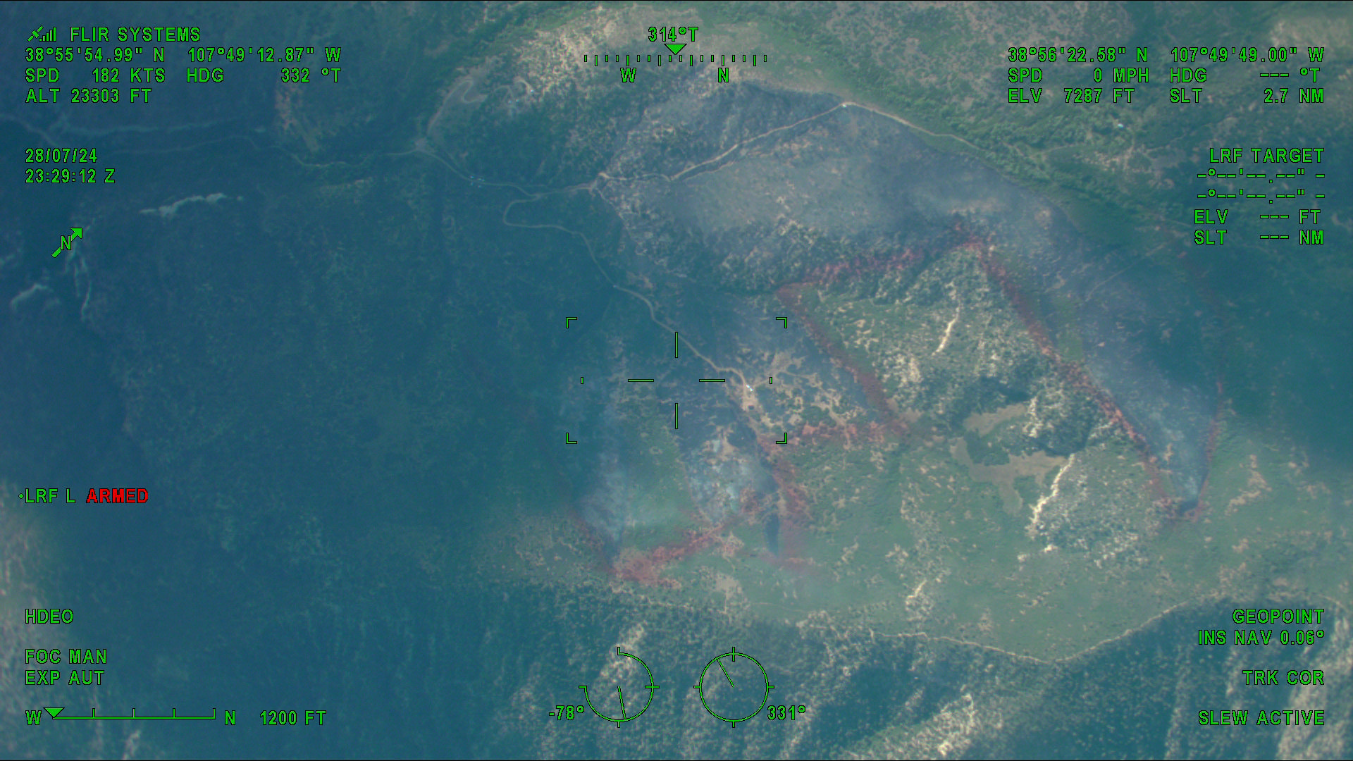
Fire Update 07 29 2024
Related Incident: Currant Creek Fire
Publication Type: News
Currant Creek Fire Update
Sunday, 7/28/24 at 9:00 PM
Size: 182 acres
Estimated Containment: 0%
Today, hand crews worked up each flank from the origin towards the ridge digging hand line and addressing hot spots near the edge to prevent spread. Two helicopters supported firefighters by delivering loads of water to douse hot spots and spot fires. Some active fire behavior was observed between the fingers going up the ridge. The northernmost finger produced a significant plume of smoke around 2 PM that could be seen from certain areas on Redlands Mesa and around Cedaredge.
However, that activity did not increase the footprint of the fire. Additional crews are due to arrive tomorrow. They will join existing resources and continue constructing line around the fire with the support of aircraft. Crews are still working on containment and pre-evacuation warnings remain in place due to continued Red Flag weather conditions forecast for Monday.
Firefighters are making good progress suppressing hotspots within the core of the fire and spot fires to prevent further growth. Fire growth was minimal today thanks to their efforts despite low humidity, high temps, and winds gusting up to nearly 30 MPH. As long as fire activity remains stable, updates will be published once daily. Additional updates may be issued if conditions change significantly, or if the pre-evacuation status changes.
Please do not call dispatch for updates about this fire. The most up to date fire information will be posted on Inciweb. Evacuation information can be found on the Delta County Sheriff’s Office Facebook or on the Delta County Website.
Durkee Fire Information Community Meeting 07 29 2024
Related Incident: Durkee Fire
Publication Type: Announcement
Durkee Fire Information
Community Meeting
July 29, 2024 @ 6:30 p.m. PDT
We invite you to receive the latest information on the Durkee Fire from the current incident management team and connect with local agency representatives.
Churchill School, 3451 Broadway St., Baker City, OR 97814
Fire Info Line: 541-208-4371
A recording of the meeting will be available on the Durkee Fire Facebook page after the event.