
2024 SQF Lightning and Borel Smoke Outlook 07 29 2024
Related Incident: 2024 SQF LightningBorel Fire
Publication Type: News
Fire
Yesterday, interior activity on the Trout Fire near Boone Meadow continued and the SE progression just south of Smith Meadow slowed. The Borel Fire was active, testing containment lines, with some progression to the south and interior consumption on the east side. Expected fire behavior on the Borel includes possible crown fire runs and spotting.
Smoke
Yesterday, smoke transport was again influenced by westerly winds and tracked to the east/northeast. The plumes from Borel and Trout fires impacted the lower Owens Valley, causing periods of USG to UNHEALTHY air quality there. Today, westerly flow will continue and western foothill communities and the North Owens Valley will see generally cleaner air with GOOD to MODERATE conditions. The southern Owens Valley can expect periods of MODERATE to UNHEALTHY conditions from Lone Pine to Ridgecrest. Lake Isabella and Kernville can expect periods of MODERATE to USG in the AM through midday as smoke mixes down and begins to track east. Conditions in Lake Isabella and Kernville should improve by late afternoon as winds increase.
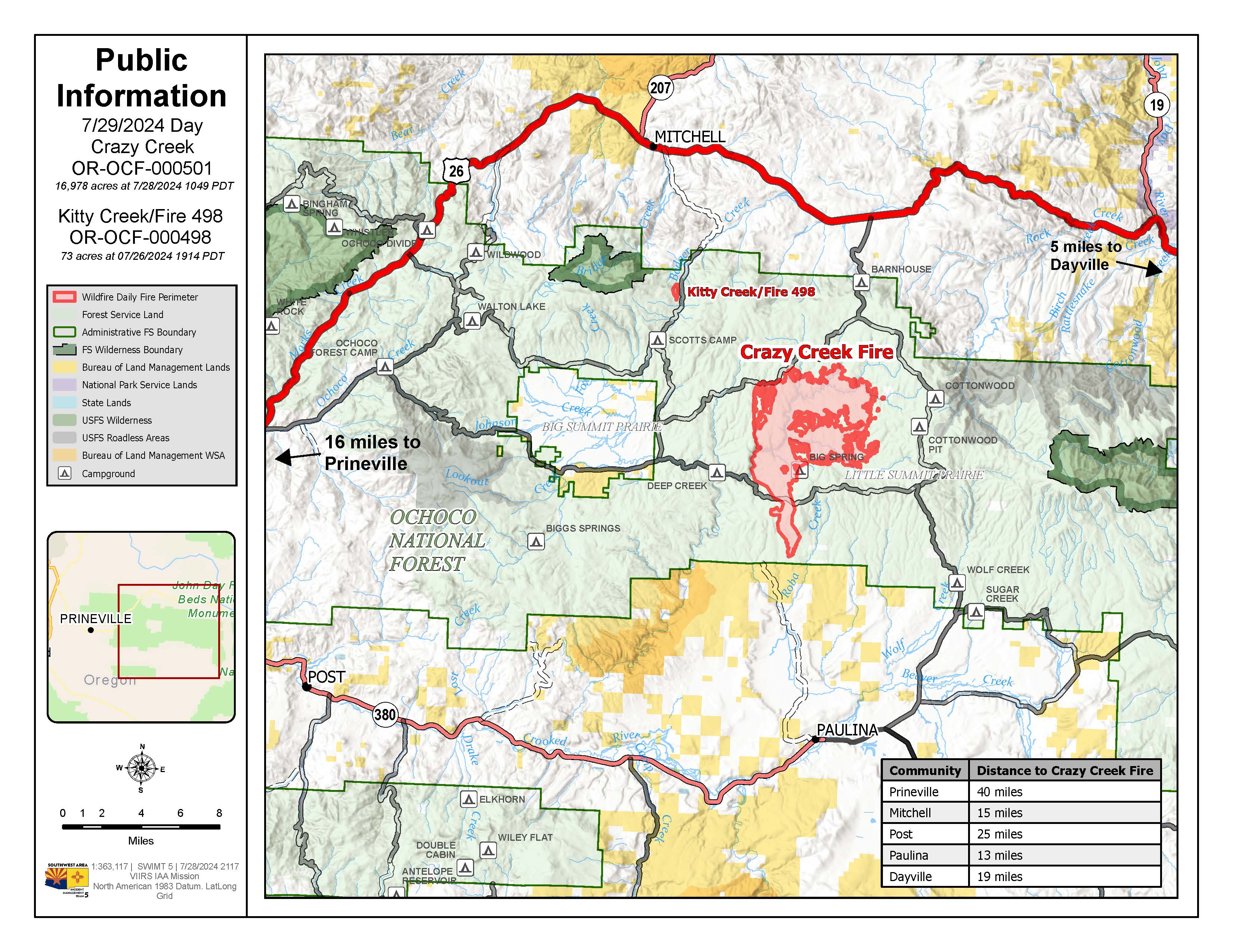
Crazy Creek Fire Daily Update for July 29 2024 07 29 2024
Related Incident: Crazy Creek
Publication Type: News
Conditions continue to challenge firefighting efforts
Daily Update July 29, 2024
Fire Information Phone:541-208-1768 (8am-8pm)
Media Information Phone: 541-208-1770 (8am-8pm)
Email: 2024.crazycreek@firenet.gov
Acres: Crazy Creek 16,978; 498/Kitty Creek 73 Start Date: July 22, 2024
Location: Crazy Creek:16 miles north of Paulina, OR Personnel: 302 total for both fires
498/Kitty Creek: 7 miles south of Mitchell, OR
Containment: Crazy Creek 0%; 498/Kitty Creek 58% Fuels: Timber and short grass
Highlights: Crews continued work Sunday on the Crazy Creek and 498/Kitty Creek fires. On the Crazy Creek fire, firefighters observed tree torching and short-range spotting, which resulted in fire growth in the south and southwest areas of the fire. There was an overnight run of approximately three miles in the southern portion. Dry, hot conditions continue to be challenging for firefighters. The fire has pushed south beyond Forest Road 42, triggering upgraded evacuation levels in the Paulina Valley area. Crews on the 498/Kitty Creek fire continued securing and improving containment lines and conducting mop-up operations including extinguishing hot spots, felling damaged trees and cooling ash pits.
Fire Activity: On the Crazy Creek fire, crews continue to construct fire lines to contain the southwest and southern portions. Across the fire, crews continue looking for opportunities to leverage features to be used as containment lines and focusing on protecting structures in Toggle Meadow and Little Summit Prairie areas.
Firefighters in the northwest area worked from the 744 and 755 roads to the 30 Road conducting overnight firing operations to secure and improve containment lines. The southern and southwestern flanks where fire conditions are the hottest, driest and with the lowest humidity showed additional growth on Sunday,
Starting Monday, crews will assess areas to the south and southwest of the Crazy Creek Fire for structures and other values to protect. Crews on the 498/Kitty Creek Fire will continue to patrol the northern half of the fire and improve the fire perimeter on the south side to increase containment.
Evacuations: On Sunday, the Crazy Creek Fire’s push south beyond FS Road 42, triggered upgraded evacuation levels in the Paulina Valley area. LEVEL 3 evacuations in the Ochoco National Forest have been expanded to the eastern boundary of Big Summit Prairie and south of the Forest boundary. LEVEL 2 evacuations now extend from the forest service boundary south to Paulina.
Weather: Monday will bring partly cloudy skies, temperatures in the 70s to 80 degrees, increasing humidity with a chance of thunderstorms with west-northwest winds 12-15 mph gusting to 25 and the potential for unpredictable outflow winds across the 498/Kitty Creek and Crazy Creek fires.
Importance of Fire Prevention: All public lands in Central Oregon, to include the Ochoco National Forest are in Public Use (Fire) Restrictions. All open flames, including woodstoves and charcoal briquette fires are prohibited. In times of high fire danger, it is crucial for everyone to follow fire prevention measures to avoid additional strain on overburdened resources. The public's cooperation in adhering to fire bans and restrictions is vital to prevent new fires from starting and to help our firefighters focus on containing the existing fires. Learn more at https://www.fs.usda.gov/alerts/ochoco/alerts-notices/?aid=89068.
Smoke: Smoke from multiple fires in Central Oregon are impacting the region. Additional details are available via https://outlooks.wildlandfiresmoke.net/outlook/079f0f73.
Fire Restrictions and Closures: The Ochoco National Forest has implemented a forest closure for the Paulina Ranger District. More information can be found at fs.usda.gov/alerts/ochoco/alerts-notices/?aid=89203.
More Information:
InciWeb: https://inciweb.wildfire.gov/incident-information/orocf-crazy-creek
Facebook: https://www.facebook.com/SWIMT5
Central Oregon Wildfire Information: https://centraloregonfire.org/
Crook County Emergency Information Map: https://arcg.is/1ij0vb
Actualizacin Diaria Apache Fire 07 29 2024
Related Incident: Apache Fire
Publication Type: News
Actualización del Incendio Apache, 29 de Julio de 2024
Inicio del Incendio Apache: martes, 23 de julio de 2024 a las 6:31 p.m.
Causa: Bajo investigación
Localización: Maricopa Highway y Apache Canyon Road, Cuyama Valley, Condado de Ventura
Tamaño en el momento de la actualización: 1,538 acres
Contención: 62%
Personal: 246
Detallescompletos del incidente: https://inciweb.wildfire.gov/incident-information/calpf-apache-fire
Recursos:
Cuadrillas con herramientas manuales: 5 Camiones de bomberos: 8 Camiones cisterna de agua: 4
La contención del incendio Apache está aumentando rápidamente y no se espera que el incendio siga creciendo. Los bomberos siguen suprimiendo los focos de calor en la línea de fuego y a lo largo de ella para reducir la posibilidad de propagación del fuego.
Se están encontrando serpientes de cascabel en la línea de fuego con mayores frecuencias comparado con los últimos días. Los bomberos recorrieron el perímetro del incendio utilizando unidades GPS y redujeron el tamaño del incendio gracias a estos métodos de medición más precisas. Sigue vigente una restricción temporal de vuelo debido al uso continuo de sistemas aéreos no tripulados para monitorear el incendio.
Las cuadrillas siguen realizando trabajos de reparación de extinción en las líneas de contingencia construidas antes de que se detuviera el avance del incendio.
El incendio está ardiendo junto a la autopista Maricopa (CA-33). La autopista permanece abierta. Se recomienda a los conductores que estén atentos a los bomberos y la maquinaria pesada en el área. Verifique las condiciones de las carreteras de Caltrans antes de conducir por la zona.
Además, con la temporada de ciervos en curso, los bomberos se encuentran con cazadores con arco a lo largo de la línea de fuego y las tierras adyacentes.
Cierre forestal: Hay un cierre forestal vigente en el área del incendio Apache, Orden forestal 05-07-57-24-18. Consulte el Bosque Nacional Los Padres (usda.gov) para obtener información adicional antes de visitar el área.
Pronóstico para el lunes: Las temperaturas serán más bajas durante los próximos días y las máximas en el área del incendio van a estar entre 90 y 95 grados. La humedad relativa se mantendrá baja, entre 17 y 25%. Los vientos soplarán del noroeste a una velocidad de entre 5 y 10 mph, con ráfagas de entre 15 y 18 mph. Es posible que haya una ligera probabilidad de precipitaciones a partir del próximo fin de semana.
Áreas de evacuación: Se han levantado todas las advertencias y órdenes de evacuación.
Redes Sociales:
Página de Facebook del Bosque Nacional Los Padres
Página de Facebook del Departamento de Bomberos del Condado De Ventura
Página de X del Departamento de Bomberos del Condado de Ventura
Apache Fire Daily Update 07 29 2024
Related Incident: Apache Fire
Publication Type: News
Apache Fire Incident Update July 29, 2024
Apache Fire Start: Tuesday, July 23, 2024, at 6:31 p.m.
Cause: Under investigation
Location: Maricopa Highway and Apache Canyon Road, Cuyama Valley, Ventura County
Size at time of update: 1,538 acres
Containment: 62%
Personnel: 246
Incident Details: https://inciweb.wildfire.gov/incident-information/calpf-apache-fire
Resources:
Hand Crews: 5 Engines: 8 Water Tenders: 4
Containment of the Apache fire is increasing rapidly, and no further growth is expected. Firefighters are continuing to suppress pockets of heat in and along the fireline to reduce the chance of fire spread.
Rattlesnakes are being encountered on the fireline at an increasing rate compared to past days. Firefighters walked the perimeter of the fire using GPS units and reduced the acreage based on the more accurate measurement methods. A Temporary Flight Restriction is still in place due to the continued use of unmanned aerial systems in monitoring the fire.
Crews are continuing to perform suppression repair work on contingency lines constructed before forward progress of the fire was stopped.
The fire is burning adjacent to Maricopa Highway (CA-33). The highway remains open. Motorists are encouraged to be alert for firefighters and equipment in the area. Please check road conditions at https://roads.dot.ca.gov/ prior to driving through the area.
Also, with the ongoing deer season, firefighters are encountering bow-hunters along the fireline and adjacent lands.
Forest Closure: A forest closure is in effect in the Apache Fire area, Forest Order 05-07-57-24-18. Please check the Los Padres National Forest page at https://www.fs.usda.gov/s/lpnffor additional information prior to visiting the area.
Forecast for Monday: Temperatures will be lower over the next couple days with highs in the fire area ranging from low to mid 90 degrees. Relative humidity will remain low at 17-25%. Winds will be out of the northwest 5-10 mph with gusts of 15-18 mph. A light chance of precipitation may be on the horizon starting the next weekend.
Evacuation Areas: All evacuation warnings and evacuation orders have been lifted.
Social Media:
Los Padres National Forest Facebook
Hill Fire Morning Update 07 29 2024
Related Incident: Hill Fire
Publication Type: News
HILL FIRE INCIDENT UPDATE
Date: July 29, 2024
Fire Information: 530-414-9056
Hours: 08:00 AM to 8:00 PM
Email:2024.Hill@firenet.gov
Incident Website:
https://inciweb.wildfire.gov/incident-information/casrf-hill-fire
https://www.fire.ca.gov/incidents/2024/7/16/hill-fire
Location: Humboldt County, CA
Size: 7724 acres
Cause: Under Investigation
Start Date: Monday July 15, 2023, at 5:40 PM
Percent contained: 61%
Personnel: 1129
CURRENT SITUATION:
Crews focused on patrolling the containment lines and mopping up hotspots yesterday, specifically at Mosquito Creek, Buck Creek, and Spike Buck Mountain, where stubborn fuels continued to smolder. Unmanned aircraft fixed with infrared cameras helped to detect heat throughout the fire area. Firefighters on foot used a tactic called “gridding,” where they patrol individual zones seeking out and extinguishing hotspots. Gridding allows crews to efficiently search large plots of land and ensure that all pockets of heat are eliminated.
While firefighters work to ensure no fire remains, other crews have begun the process of equipment and trash removal and suppression repair. All used equipment will be packed up and hauled back out. Yesterday, crews backhauled around 100,000 feet of hose from the containment zones. That’s almost 19 miles of hose! Suppression repair has also been completed from the South Fork of the Trinity River to Route 1.
WEATHER:
A lifting marine layer will envelop the fire over the next couple days, bringing unusually moderate relative humidity and cool temperatures. Winds will remain gentle to calm with afternoon sea breeze from the northwest being the strongest wind. The marine inversion may still bring some poor humidity recovery overnight, especially peaks above 4000 feet, but dry period overnight will be particularly isolated and short lived. Despite and increased mixing height, generally low instability will inhibit smoke and mixing.
CLOSURES:
Forest Closure Order currently in effect for the area impacted by the Hill Fire. It is temporarily prohibited to be on any national forest system land, trail, or road within the closure area. To view the closure order and map of closure area visit the following link www.fs.usda.gov/Internet/FSE_DOCUMENTS/fseprd1191963.pdf.
Road closures are currently in place on Friday Ridge Rd. at Forest Service Route 6N06, Friday Ridge Rd. at Forest Route 5N01 and Friday Fridge Rd. at Forest Route 5N04. For updated road closure information, visit protect.genasys.com or humboldtsheriff.org/emergency.
FIRE RESTRICTIONS:
Forest fire restrictions also went into effect on July 12th. Campfires and stove fires are restricted to those developed areas listed in the forest order located at https://www.fs.usda.gov/Internet/FSE_DOCUMENTS/fseprd1188610.pdf.
Smoking, welding, and operating an internal combustion engine also have restrictions in place.
EVACUATIONS:
Humboldt County: Evacuation order and warnings remain in effect. For current updates on evacuations, visit https://www.facebook.com/HumboldtSheriff and https://humboldtgov.org/2383/Current-Emergencies.
Conditions are subject to change at any time, visit https://protect.genasys.com/search for a full zone description.
Sign up for Humboldt Alert emergency notifications at https://humboldtgov.org/2014/Emergency-Notifications
Trinity County: Evacuation warnings remain in effect. For current updates on evacuations, visit https://www.facebook.com/profile.php?id=100064589806351 and https://www.trinitycounty.org/OES
Evacuation Center:
For information on assistance available to those displaced by the Hill Fire, please call 1-800-RED-CROSS (1-800-733-2767.)
The Humboldt County Sheriff’s Office of Emergency Services in coordination with the Humboldt County Department of Health & Human Services and the American Red Cross-Gold Country Region established an Evacuation Center for those impacted by the Hill Fire to receive fire information. The Evacuation Center is located at Trinity Valley Elementary School, 730 CA-96 in Willow Creek. The center is not open to the public, however information on how to request assistance is posted at this location.
Grouse Fire Update 07 29 2024
Related Incident: Grouse
Publication Type: News
Grouse Fire Update
Incident Commander: J. Willoughby, J. Hansen (T)
Location: 10 miles southwest of Wise River, MT
Start Date: 7/25/2024
Cause: Undetermined
Size: estimated at 185 acres
Resources on Site: 2 type 2 hand crews; 5 engines; 2 helicopters available to assist
Total Personnel: 60
KEY MESSAGES:
The fire is burning in the upper end of Grouse Creek off the Pioneer Scenic Byway on the Wisdom Ranger District. Fire behavior has been extreme, with torching and short upslope runs in heavy timber. Fire managers are urging people to stay out of the fire area for safety reasons.
Fire managers and agency officials are discussing necessary area, road, and trail closures. Ensuring public and firefighter safety and protecting life and property are of the utmost importance.
CURRENT STATUS/PLANNED ACTIONS:
The fire is moving primarily up the Grouse Creek drainage and sub-drainages. Both flanks or sides of the fire are moving actively, with fire backing downhill towards Pettengill Creek and spotting to the north towards Grouse Creek.
Firefighters are assessing structures from the junction of Pettengill Road and along the Pioneer Scenic Byway to the north. They will be scouting for opportunities for firefighting operations, utilizing both natural and manmade control features. Crews will be working to improve and bolster fuel breaks previously constructed during the Alder Creek Fire of 2021. Firefighters will be installing water-handling equipment (pumps, hoses, and sprinklers) around structures in the Pettengill Creek area.
WEATHER AND FIRE BEHAVIOR:
The fire is burning mainly in a subalpine fir fuel model, in heavy timber on steep rocky terrain. Available fuels are unseasonably dry and include large amounts of standing dead and down trees. Fire behavior has been very active and extreme, including individual and group tree torching on all flanks and spotting. Dead fuels along the ridges at the highest elevations are consuming completely. If winds align with terrain, in combination with the dry fuels, extreme fire behavior with active movement can be expected. These conditions pose additional hazards to firefighters, limiting access and affecting on-the-ground progress.
Weather on Monday trends warmer with increased wind in the afternoon, elevating fire weather concerns. The next change for precipitation will be Tuesday, with chances for showers and thunderstorms throughout the day. High temperatures will be in the 80s, with breezy conditions and gusts to 30 mph. Widespread haze will persist.
Gold Complex Update 08 05 2024
Related Incident: Gold Complex
Publication Type: News
Quick Facts
Acres: Mill, 2,962; Smith, 45
Containment: Mill 100%; Smith 100%
Detection Date: July 22, 2024
Cause: Lightning
Crews: 4
Engines: 8
Dozers: 1
Helicopters: available as needed
Total resources: 146
Fixed wing: available as needed
Headlines
- This is the final update unless there is a significant change. All fires in the Gold Complex will be 100 percent contained at 6 p.m. today.
- Today the Gold Complex will transition from the Plumas National Forest Type 3 Incident Management Team to a local Type 4 organization at 6 p.m.
- “I would like to thank our local communities for their support, cooperation and understanding as we work on fighting the fires in the Gold Complex,” said Incident Commander Don Fregulia. “We ask for continued support as wildland firefighters work towards full control of the fires.”
- As resources are increasingly released from the Gold Complex, area residents and visitors are asked to watch for increased firefighter traffic on area roads and highways, as well as resources continuing to travel to the Gold Complex fire area.
- Closure orders are still in effect on the Tahoe and Plumas National Forests in the area southeast of the junction of California Highways 70 and 89 to the Tahoe Forest boundary west of County Road A 23.
- Area residents and visitors should avoid the fire area. There are still actively burning fuels within the containment lines and other hazards following the fires.
Operational Update
Smith Fire: The Smith Fire is in patrol status and there is a continued firefighter presence in the area. Some isolated smokes may occasionally be visible in the far interior, especially during the afternoons and evenings.
Mill Fire: Firefighters are continuing to work on mop up, suppression repair and patrol. Backhaul of supplies is continuing. There are pockets of interior burning which may become more visible with increased smoke.
Weather
Sunny, hot and dry weather is in the forecast today and into the coming week.
Wildland Fire Prevention
The Plumas National Forest is currently under Stage 2 Fire Restrictions and the Tahoe National Forest is now in Stage 3 Fire Restrictions. Be familiar with the restrictions for the national forest you are planning to recreate on. If you are in an area on the Plumas National Forest where you can have a campfire, make sure it is dead-out and cold to the touch. Be careful with anything that can spark a wildfire. Report suspected wildfires by calling 911.
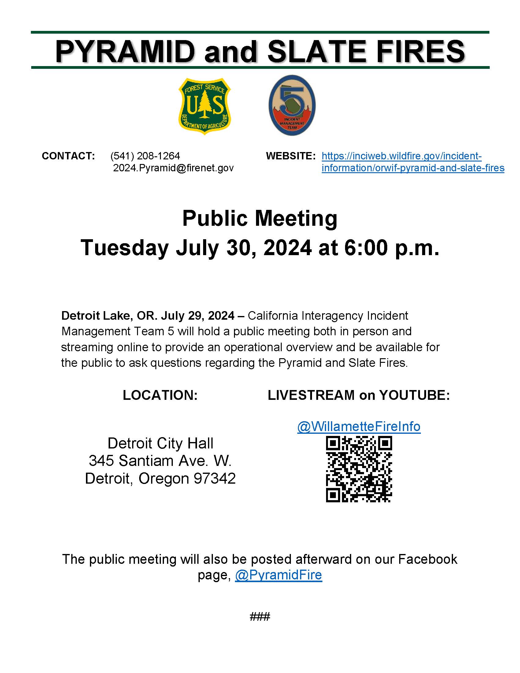
Pyramid and Slate Fires Community Meeting 07 29 2024
Related Incident: Pyramid and Slate Fires
Publication Type: Announcement
A community meeting will be held tomorrow Tuesday July 30, 2024, at 6:00p.m. at the Detroit City Hall
345 Santiam Ave. W. Detroit, Oregon 97342
This meeting will be livestreamed on YouTube @WillametteFireInfo. The meeting will also be posted afterward on our Facebook page @PyramidFire.
Blacktail Canyon Fire Update 07 29 2024
Related Incident: Blacktail Canyon
Publication Type: News
Blacktail Canyon Fire Update
Incident Commander C. Enriquez
Location: southeast of Butte, MT between Interstate 90 and Highway 2
Start Date: 7/19/2024
Cause: Undetermined
Size: 80 acres
Resources on Site: 2 engines; 1 type 2 hand crew
Total Personnel Assigned: 79
Containment: 95%
KEY MESSAGES:
This will be the FINAL daily update for the Blacktail Canyon fire.
Please continue to follow the Inciweb site for any updates on fire activity and status.
The proximity of the fire location to recreation sites such as the Continental Divide Trail and the Silver Bow Archery Range in Thompson Park presents a further need for public awareness. The public is advised to remain vigilant and aware of hazards associated with a recently burned area.
CURRENT STATUS/PLANNED ACTIONS:
Previously constructed firelines held, despite gusty winds over several days. Firefighting efforts have resulted in securing sections of the fire edges, 3 chains (198 feet) into the interior. Crews will continue securing the constructed lines and “mopping-up” all the way around the fire footprint.
Fire managers are calling the fire 95% contained. Containment of a fire implies there are secure firelines around the perimeter, directly next to the edge where the fire burned. As the crews progress around the entire fire perimeter with “mop-up” and extinguish all residual heat interior to the fire edge, the containment percentage will increase.
WEATHER AND FIRE BEHAVIOR:
Fire behavior was minimal yesterday. Little to no smoke was visible.
Elevated fire weather conditions are expected Sunday and Monday, given gusty west-southwest winds of 20-25 mph and humidity in the upper teens. Mid-level moisture will increase into Sunday morning, leading to an isolated threat for showers and thunderstorms. Another round of showers and thunderstorms will develop Sunday afternoon. Showers and thunderstorms will be high based and mainly dry, with chances for wetting rains at 10 percent.
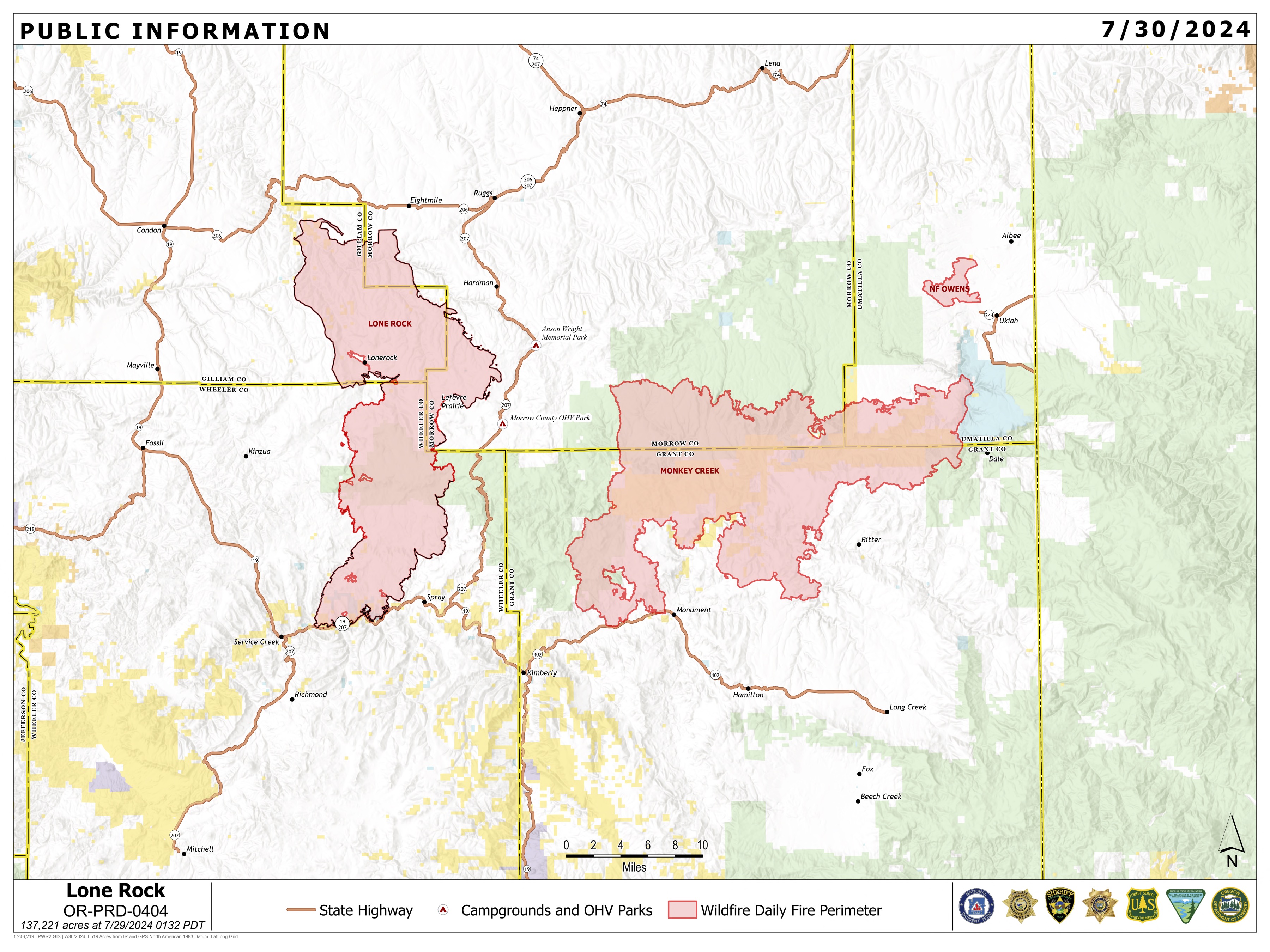
Lone Rock Fire Update July 30 2024 07 30 2024
Related Incident: Lone Rock Fire
Publication Type: News
LONE ROCK FIRE UPDATE July 30, 2024
Location: Lonerock, Ore. to west of Highway 207 | Size: 137,221 acres | Containment: 77% Cause: Under Investigation
Start Date: July 13, 2024 | Total Personnel: 633
InciWeb: https://inciweb.wildfire.gov/incident-information/orprd-lone-rock-fire
Fire Information Line: 541-208-4369
Email: 2024.0404rvlonerock@firenet.gov
Condon, Ore. — The Lone Rock Fire is being managed under a full suppression strategy by Northwest Incident Management Team 2 (NW2).
Yesterday’s Activities: The rain and lower temperatures provided favorable conditions for firefighters working the line yesterday, with some areas receiving up to 0.25 inch of rain. Firefighters continued mop-up operations on the east side of the fire between Forest Service Road (FSR) 21 and FSR 25. Work around the slopover near Notch Road has been greatly successful, allowing the area to be transitioned to a patrol status. Firefighters patrolling the north end of the fire, OR-19, and Alder Creek Road had no issues to report, and received no calls from residents reporting smoke or fire concerns.
Today’s Activities: Today is the last shift for Northwest Incident Management Team 2. Southwest Area Incident Management Team 2 will assume command of the incident starting at 0600 tomorrow morning. NW2 team members will be briefing the Southwest team about the current situation of the incident and getting them set up for a successful transfer of command.
The operational focus today will remain the same as yesterday, patrolling containment lines and continuing to mop-up areas that show signs of residual heat. Clean up work will also continue along FSR 25, OR-19, and Lonerock Road.
Evacuations:
There are no Level 3 evacuations in place for the Lone Rock Fire.
- For Gilliam County evacuation information, visit Gilliam County Sheriff's Office Facebook page.
- For Wheeler County evacuation information, visit Wheeler County Sheriff’s Office Facebook page.
- For Morrow County evacuation information, visit Morrow County Sheriff's Office Facebook page.
Closures:
• For updated road closure information, visit https://www.tripcheck.com/.
- Umatilla National Forest Order Number 06-14-02-24-02 includes prohibitions within the Heppner Ranger District on the Umatilla National Forest.
- Bureau of Land Management (BLM) Prineville District Office issued an Emergency Public Land Closure on BLM-managed lands along the main stem John Day River and along the North Fork John Day River from Kimberly, Ore. to Dale, Ore.
Weather: Tuesday will be cool with highs in the mid 70s to mid 80s. Excellent relative humidity recoveries overnight will result in relative humidity values between the high 30s to low 40s. Winds are expected to be light and terrain driven.
Smoke Information: Visit https://fire.airnow.gov/ for local air quality information.
Flight Restrictions: A Temporary Flight Restriction (TFR) is in place above the Lone Rock Fire area.
###