
Baker County Sheriffs Office Evacuation Level Update for 7282024 07 28 2024
Related Incident: Durkee FireCow Valley Fire
Publication Type: Announcement
Baker County -Evacuation Level Update for 7/28/24-
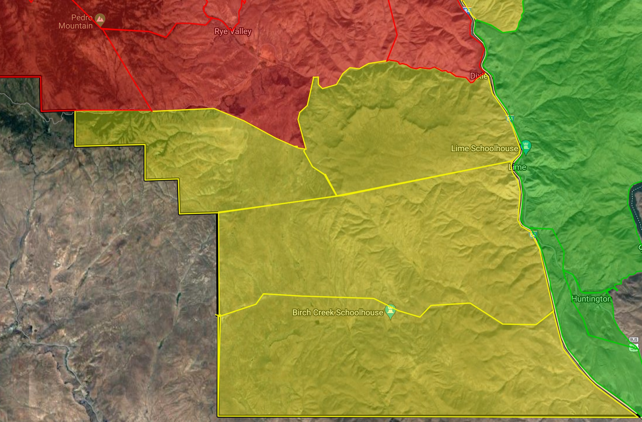
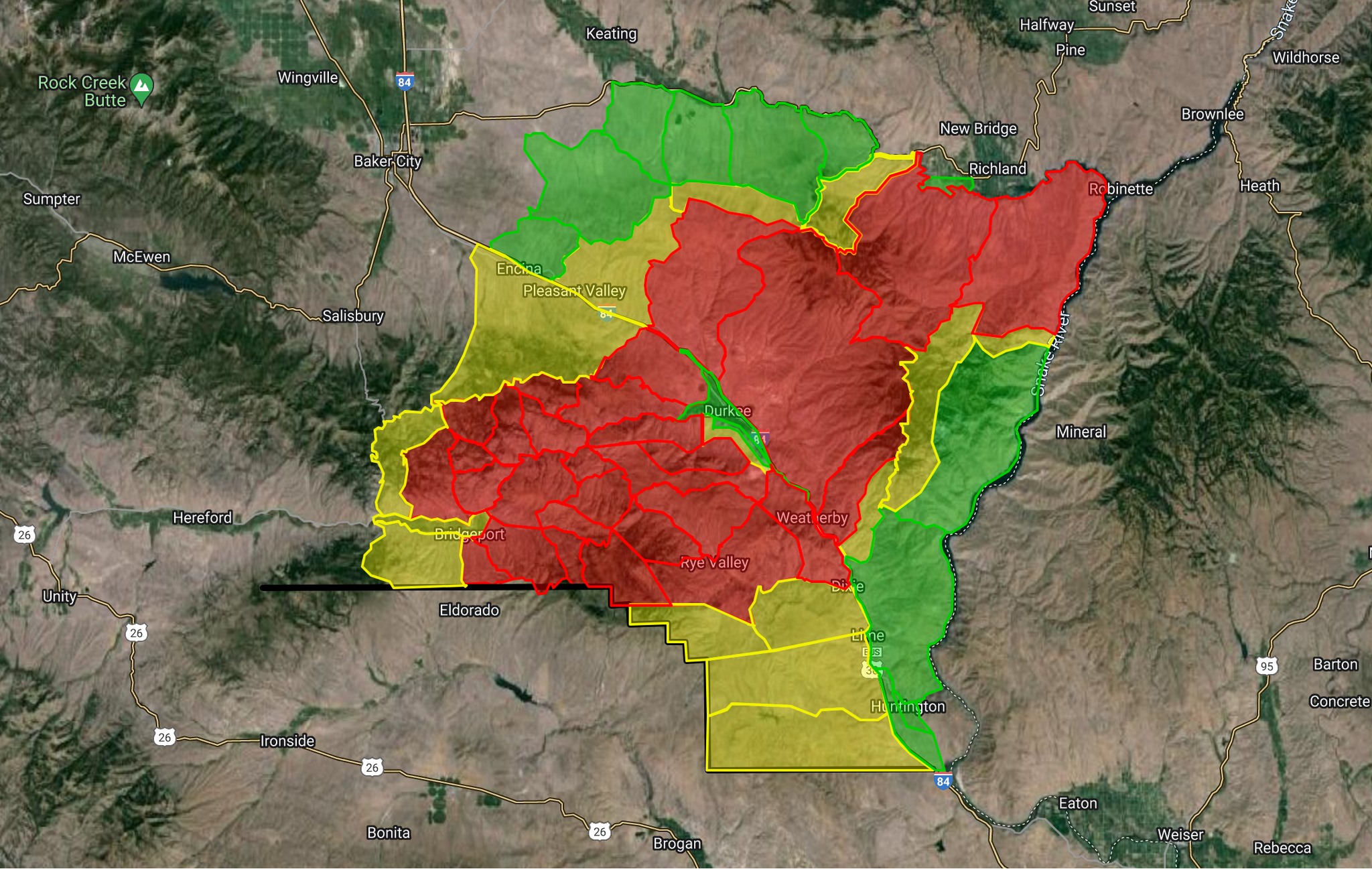
Level 2 (BE SET) has been issued for Rye Valley Lane and Mormon Basin Road, south to the Baker County line. This area was previously a Level 3 but has been reduced.
All other evacuation levels are expected to remain the same throughout today.
Settings - change map background and toggle additional layers
Filter - control incident types displayed on map.
Zoom to your location
Reset map zoom and position
Could not determine your location.
Show Legend
 Wildfire
 Prescribed Fire
 Burned Area
Response
Burned Area
Response Other
Other
Bulltrout Fire
Unit Information
Incident Contacts
Durkee Fire Update for Sunday July 28 2024 07 28 2024
Related Incident: Durkee Fire
Publication Type: News
Durkee Fire Update for Sunday, July 28, 2024
DURKEE FIRE
- Size: 288,690 acres
- Containment: 49%
- Location: 1 mile west of Durkee, OR
- Start Date: July 17, 2024
- Personnel: 608
- Cause: Lightning
DURKEE FIRE PUBLIC MEETING – MONDAY JULY 29, 2024, at 6:30 p.m. PDT
A public meeting on the Durkee Fire will be held at the Churchill School, 3451 Broadway St., Baker City, OR at 6:30 p.m. PDT on Monday July 29, 2024.
Change in Incident Management Team
Today at 6 a.m. the Southern Area Gold Complex Incident Management Team assumed management of the fires under the leadership of Incident Commander Debbie Beard. The Gold Team expresses its appreciation to NW Team 6, Oregon State Fire Marshals, cooperators, collaborators and the community for their support to the firefighters.
Current Situation
Yesterday’s weather helped firefighters make good progress, increasing containment on the Durkee Fire to 49%. Crews engaged on the active area of the fire that is backing slowly down towards I-84, continuing to check its progress and mop up where possible. On the north side of the fire, conditions allowed firefighters to engage in direct attack, setting up control lines and mopping up along the edge. Crews constructed a key dozer line in Dark Canyon. Along the east and south sides of the fire, crews patrolled and mopped up. In the Bridgeport area, firefighters have been working to complete dozer lines east of the 245 Road system, tying together some of the roads and putting in contingency lines. Crews have also begun mopping up along those lines. On the northwest edge of the fire, firefighters are scouting out potential lines and securing the edges of primary dozer lines to prepare for strategic firing operations if needed.
Firefighters sometimes use strategic firing operations to bring uncontrolled fire to a more manageable location within fire control lines. Strategic firing operations are also used to bring fire to a specific control feature (road, trail, handline, dozer line) where firefighters can safely and effectively manage and monitor the fire. They also can be conducted by helicopter or drone when conditions are too dangerous to place firefighters in the area.
Today firefighters will continue working on spot fires near I-84 and on a pocket of active fire in Shirttail Creek. They also will continue to connect and secure containment lines on the fire’s north side and finish prepping line on the 11 Road. On the fire’s west side, firefighters will continue to hold, mop up and patrol containment lines.
Two helicopters are assigned to the fire. Other aircraft in the area are available if needed. Firefighters will be flying a reconnaissance mission and using the heavy helicopter for bucket work on the north side of the fire.
OSFM is demobilizing all task forces today as the structural threat from the Durkee Fire has diminished.
Weather and Fire Behavior
Today northwesterly winds will continue until early afternoon when southwest winds begin gusting 25-35 mph creating difficult firefighting conditions on the uncontained northern edge of the fire. Northwesterly winds will resume in the evening. There is a 5% chance of rain. Humidity recovery continues to be poor with minimum relative humidity in the teens creating dangerous burning conditions. Possible thunderstorms on Monday and Tuesday are unlikely to bring much rain. However, lightning could threaten very dry fuels.
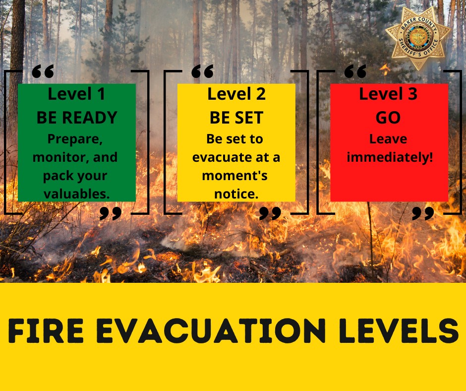
Evacuations
The Malheur County Sheriff’s Office (https://www.facebook.com/profile.php?id=100069245917855) and the Baker County Sheriff’s Office (https://www.facebook.com/profile.php?id=100064434892363) have issued evacuations for multiple areas during the Durkee Fire. Some evacuation levels have lessened.
Residents in Level 3 Evacuations “GO NOW” should leave immediately and not return to their property until evacuation levels are removed. Carry enough supplies to support you and your family for multiple days. A real-time map of fire evacuations is available on the State of Oregon Fire Dashboard (https://www.arcgis.com/apps/instant/portfolio/index.html?appid=22d04c007866419c91ccf00d097526c8).
Closures:
- The Baker County Sheriff's Office has closed Burnt River Canyon Road to non-local, non-emergency traffic.
- I-84 and other highways: Please go to tripcheck.comfor current road closures as the situation is dynamic and subject to change.
- A Burn Ban is currently in effect for all of Malheur County (https://www.malheurco.org/category/public-notices), and all Bureau of Land Management lands in Malheur and Baker counties. For more information, visit.
- A Temporary Flight Restriction remains in effect over the Durkee Fire (https://tfr.faa.gov/save_pages/detail_4_6061.html). Please remember, if you fly we can’t! If a drone or other aircraft enters the air space, all firefighting aircraft will be grounded.
Additional Resources:
- For current smoke information, visit airfire.org.
- Weather and fire behavior could impact transportation, power transmission, cell service and other utilities. Monitor IdahoPower.com for information.
Microwave Tower Fire Update Mosier Community School July 28 2024 07 28 2024
Related Incident: Microwave Tower Fire
Publication Type: Announcement
Microwave Tower Fire Update, Mosier Community School, July 28, 2024, 7 PM
Pioneer Fire Evacuation Updates July 28 2024 07 28 2024
Related Incident:
Publication Type: Announcement
Pioneer Fire Evacuation Level Updates: Along with the new Level 3 from just north of Moore Point through Stehekin, evacuation levels changed down lake as well today. They are being downgraded.
Moore Point to Safety Harbor has been downgraded to a Level 2. Safety Harbor to Camas Creek has also been downgraded to a Level 1 fire advisory. And the Level 1 fire advisory has been lifted from Camas Creek to Mitchell Creek.
Keep up on evacuation levels in Chelan County at https://chelangis.maps.arcgis.com/.../media/index.html...
Grouse Fire Update 07 28 2024
Related Incident: Grouse
Publication Type: News
Incident Commander: A. Jones
Location: 10 miles southwest of Wise River
Start Date: 7/25/2024
Cause: Undetermined
Size: estimated at 70-80 acres
Resources on Site: 3 type 2 hand crews; 2 engines; 2 helicopters available to assist
Total Personnel: approximately 80
KEY MESSAGES:
Reduced visibility from smoke drifting in from fires in the Pacific Northwest prevented firefighters from flying aircraft to get a good visual on the fire’s location yesterday.
Fire managers are urging people to stay out of the fire area for safety reasons.
CURRENT STATUS/PLANNED ACTIONS:
The fire is burning in the upper end of Grouse Creek off the Pioneer Scenic Byway on the Wisdom Ranger District. Firefighting resources responded to the fire, and three helicopters assisted with water bucket drops during the initial attack phase. Fire retardant from air tankers is not effective in these fuel and landscape conditions. Crews disengaged during the afternoon hours of July 26 due to active fire behavior and the lack of safety and/or landing zones for helicopters. Firefighters will assess the situation on the ground, scouting for opportunities to access the fire and create safe anchor points for firefighting operations. Ensuring firefighter safety and protecting life and property are of the utmost importance.
Working in cooperation with our interagency partners and local community officials, fire managers will be meeting to identify and prioritize critical values at risk. Additional resources have been ordered. As they arrive, fire managers and agency officials will collaborate to utilize resources to protect the prioritized values.
WEATHER AND FIRE BEHAVIOR:
The fire is burning mainly in a subalpine fir fuel model, in heavy timber on steep rocky terrain. Available fuels include large amounts of dead and down trees. These conditions pose additional hazards to firefighters, limiting access and affecting on-the-ground progress.
Fire behavior has been very active and extreme, including individual and group tree torching on all flanks and spotting. Dead fuels along the ridges at the highest elevations are consuming completely, given the intense fire behavior.
The forecast includes a 30% chance of showers and thunderstorms, mainly in the afternoon and early evening. Light and variable wind becoming west 8 to 13 mph in the morning. Winds could gust as high as 23 mph.
Red Fire Daily Update 7282024 7282024 07 28 2024
Related Incident: Red Fire
Publication Type: News
Red Fire
July 28, 2024
Daily Fire Update
Online: https://inciweb.wildfire.gov/incident-information/ordef-red-fire Facebook – 2024 Red Fire Information
Fire Information Line: 541-208-1766, 8:00 AM – 8:00 PM Email: 2024.red@firenet.gov
Red Fire Quick Facts
Size: 433 acres Origin: 5 miles west of Crescent Lake Junction, Oregon County: Klamath
Start Date: July 17, 2024 Cause: Lightning Containment: 0% Total Personnel: 246
Operations: Firefighters continued to construct handlines around the structures near Odell Lake and down to the lake. Hand crews worked along Forest Service Road 60 to reduce concentrations of vegetation 50 to 100 feet off the road. Heavy equipment and crews continued their progress from the east end of the Odell Lake to the south and west decreasing vegetation loading. Shaded fuel break construction continued along the Union Pacific Railroad lines.
Today, two timber task forces will continue to create defensible space around critical structures and other values north and west of the Odell Lake area and the Union Pacific Railroad tracks to the east. Firefighters will continue to install a shaded fuel break 200 feet in along the boundary of the Diamond Peak Wilderness. Structure protection crews will continue to evaluate critical values in the Crescent Lake area. Engineers will assess and develop a plan to mitigate impacts from hauling logs along Forest Service Roads 6010 and 6020.
Round Mountain & Wickiup Fires –
Crews are cold trailing as they continue to mop up the Round Mountain and Wickiup Fires.
Cold trailing is making sure a fire is dead out by carefully feeling with the hand to detect any remaining burning material to locate and eliminate hot spots that could potentially rekindle a fire.
The Round Mountain Fire remains 108 acres and is 70% contained.
The Wickiup Fire remains 168 acres and is 80% contained.
Closures – The Deschutes National Forest has implemented an emergency closure around Crescent Lake and in the Diamond Peak Wilderness. Closure information is available at: https://www.fs.usda.gov/alerts/deschutes/alerts-notices/?aid=89091
Evacuation Notices – The WILDFIRE! Level 1 – BE READY to Evacuate notice issued by Klamath County Emergency Management for the Crescent Lake, Odell Lake, and Crescent Junction area remains in effect (INCENDIO FORESTAL! Nivel 1 - ESTÉ PREPARADO para evacuar de las siguientes zonas: Crescent Lake, Odell Lake, Crescent Junction). For information, or to sign up for alerts, visit: www.klamathcounty.org/300/emergency-management
Fire Restrictions – Stage 2 Public Use Fire Restrictions which prohibit open fires, including in developed campgrounds, are in effect for the Deschutes National Forest. Visit the Deschutes National Forest’s website fs.usda.gov/detail/deschutes/home/?cid=stelprdb5297376 for more information. The Industrial Fire Precaution Level is currently Level IV “General Shutdown”.
Weather: Humidities will increase upwards of 35% creating damper air. Temperatures will climb into the mid 70’s near the fire area. Winds will remain very light in the morning hours with development of 20-25 mph northwest winds in the afternoon.
Smoke: Smoke from the Red Fire and other area fires will continue to impact air quality. Air quality information can be found at https://fire.airnow.gov/.
Settings - change map background and toggle additional layers
Filter - control incident types displayed on map.
Zoom to your location
Reset map zoom and position
Could not determine your location.
Show Legend
- Wildfire
- Prescribed Fire
- Burned Area
Response
- Other
Grouse
Unit Information
Incident Contacts
Blacktail Canyon Morning Update 07 28 2024
Related Incident: Blacktail Canyon
Publication Type: News
Incident Commander J. Willoughby
Location: southeast of Butte, MT between Interstate 90 and Highway 2
Start Date: 7/19/2024
Cause: Undetermined
Size: 80 acres
Resources on Site: 2 engines; 2 type 2 hand crews
Total Personnel Assigned: 79
Containment: 95%
KEY MESSAGES:
The evacuation warning issued by Butte-Silver Bow Law Enforcement Department has been rescinded.
The proximity of the fire location to recreation sites such as the Continental Divide Trail and the Silver Bow Archery Range in Thompson Park presents a further need for public awareness. The public is advised to stay out of these areas, as crews and helicopters continue their work. Ensuring firefighter safety and protecting life and property are of the utmost importance during any incident.
CURRENT STATUS/PLANNED ACTIONS:
Previously constructed firelines held, despite gusty winds over several days. Firefighting efforts have resulted in securing sections of the fire edges, 3 chains (198 feet) into the interior. Crews will continue securing the constructed lines and “mopping-up” all the way around the fire footprint.
Fire managers are calling the fire 95% contained. Containment of a fire implies there are secure firelines around the perimeter, directly next to the edge where the fire burned. As the crews progress around the entire fire perimeter with “mop-up” and extinguish all residual heat interior to the fire edge, the containment percentage will increase.
WEATHER AND FIRE BEHAVIOR:
Fire behavior was minimal yesterday. Little to no smoke was visible.
Elevated fire weather conditions are expected Sunday and Monday, given gusty west-southwest winds of 20-25 mph and humidity in the upper teens. Mid-level moisture will increase into Sunday morning, leading to an isolated threat for showers and thunderstorms. Another round of showers and thunderstorms will develop Sunday afternoon. Showers and thunderstorms will be high based and mainly dry, with chances for wetting rains at 10 percent.
Actualizacin diaria del incendio Pioneer 28 de julio de 2024 07 28 2024
Related Incident:
Publication Type: News
Actualización diaria del incendio Pioneer
28 de julio de 2024
Tamaño: 33,277 acres
Fecha de inicio: 8 de junio de 2024
Ubicación: 31 millas al NO de Chelan, WA
Contención: 10%
Personal: 712
Causa: De orígen humano, a ser determinada
Recursos asignados: 11 cuadrillas, 4 helicópteros, 24 camiones de bomberos, 27 tanques de agua, 18 maquinarias pesadas
SITUACIÓN ACTUAL: Ayer, el incendio Pioneer brincó el desagüe de Fourmile y avanzó más al norte. Este desplazamiento resultó en que el Departamento de gestión de emergencias del condado de Chelan emitiera un aviso de evacuación de Nivel 3 (¡Váyase ya!) a partir de las 8 a.m. del domingo 28 de julio para la comunidad de Stehekin, desde el norte de Moore Point hasta el valle de Stehekin. Hay más información disponible, lo que incluye los horarios de los botes e información de los refugios para las evacuaciones, en el sitio del Departamento de gestión de emergencias del condado de Chelan en https://t.ly/QoH9w. Se reducjo el nivel de evacuación desde Safety Harbor hasta Moore Point a un Nivel 2.
Los bomberos han estado trabajando en colaboración con el grupo de protección de estructuras movilizadas por el estado, para proteger a la comunidad de Stehekin. Debido a estos esfuerzos coordinados, se han instalado sistemas de mangueras y rociadores, se ha minimizado el material inflamable alrededor de casas y estructuras, y se ha construido un cortafuego alrededor del pueblo. Ayer, los bomberos removieron árboles caídos y continuaron protegiendo estructuras y colocando más mangueras y rociadores, mientras que removían rocas y material vegetal por encima de la carretera desde el desembarco hacia el valle de Stehekin que conduce a un paso seguro para llegar al punto de acceso a los botes. A lo largo de la orilla del lago, continuaron patrullando y extinguiendo material combustible alrededor de las estructuras.
La mayor parte de la actividad y propagación reciente del fuego ha sido en la esquina noroeste del incendio, aunque también hay fuego activo en el desagüe de Prince Creek. Se ha contenido la mayor parte del borde a lo largo de la orilla del lago y a lo largo del extremo este, y el fuego no brincado la cordillera Sawtooth. Aún no hay indicación de calor en el desagüe de Lone Fir ubicado en el extremo sur. Los bomberos continúan monitoreando el extremo sur y mejorando las líneas de contingencia cerca de Manson.
ACTIVIDADES DE HOY: En Stehekin, los bomberos continuarán mejorando el cortafuego y preparándose para proteger las viviendas e infraestructura. También estarán llegando otros bomberos de Lucerne para apoyar con el trabajo de quema estratégica en Stehekin. A lo largo de la orilla del lago, las cuadrillas continuarán patrullando, extinguiendo material combustible, y realizando quemas estratégicos alrededor de las estructuras donde sea necesario y según lo permitan las condiciones. También seguirán mejorando las carreteras y las líneas de continencia al sur del incendio y al este de Manson. Los bomberos también están preparados para ayudar en atacar cualquier nuevo incendio.
CLIMA Y HUMO: De nuevo hoy se esperan condiciones calientes y secas, con vientos ligeros a través del día y ráfagas a media tarde y noche de hasta 15 mph. Las temperaturas estarán entre los 70 y los 80 grados. El lunes, se esperan lluvias ligeras sobre el incendio. Una alerta de calidad del aire se ha emitido para el condado de Chelan. Consulte el Pronóstico actual del humo para el centro norte de Washington (airfire.org) para más información sobre el humo y la calidad del aire.
EVACUACIONES: Los niveles 1, 2 y 3 de evacuación siguen vigentes alrededor del incendio Pioneer. Visite https://t.ly/QoH9w para tener más información.
CIERRE DEL BOSQUE: Cierres vigentes del Parque nacional North Cascades: https://www.nps.gov/noca/index.htm
El Bosque Nacional Okanogan-Wenatchee ha emitido una orden de cierre sobre gran parte del área afectada por el incendio: https://bit.ly/PioneerClosure. Las fogatas están prohibidas. Hay una restricción temporal de vuelo (TFR, en inglés) sobre el área del incendio: https://tfr.faa.gov/save_pages/detail_4_6779.html. La actividad de drones no autorizados está prohibida por la TFR.
InciWeb: https://inciweb.wildfire.gov/incident-information/wases-pioneer
Facebook: https://www.facebook.com/profile.php?id=61560760893080
Línea de información sobre el incendio: 541-861-5808, de 8 AM a 8 PM
Correo electrónico: 2024.pioneer@firenet.gov