
2620 Road Fire Update 08 23 2024
Related Incident: 2620 Road Fire
Publication Type: News
2620 Road Fire
Incident Commander: Kent Stanford/Blair Joiner
Fire Information Phone Number: 360-323-1903
Email: 2024.2620Road@firenet.gov
Facebook: www.facebook.com/2620RoadFire2024
InciWeb: https://inciweb.wildfire.gov/incident-information/waolc-2620-road-fire
Update as of: August 23, 2024
Estimated size: 403 acres
Containment: 15%
Start Date/Time: 8/14/2024 at 5:00 PM
Area of Origin: West of Brinnon, North of Duckabush Rd. on Mt. Jupiter
Cause: Undetermined
Structures Damaged: None
Update: Containment around the fire increased to 15% yesterday! Mop up using extensive hose lays will continue around the fire, aided by helicopter bucket drops in areas of steep, inaccessible terrain. Crews are mopping up 100 to 300 feet inside the containment line in an effort to reduce the potential of fire crossing the lines. Overnight rain has created poor road conditions and slippery footing for crews, but a strong effort is being made to continue work. Fire Management is closely watching incoming weather and adjusting tactics to ensure crew safety during ongoing field operations.
There will be considerable movement of equipment and personnel today in order to continue fire line construction and mop up efforts. Thank you to the public for continuing to stay out of the fire area while crews are working. The last few weeks have been challenging for everyone. Fire Management appreciates the support, patience, and understanding in the community during this time. Great work has been accomplished, and more great work is underway.
Weather: There is a higher chance of showers with significant accumulation across the fire area over the next several days. Accumulation is expected between 0.1” and 0.75” of rain.
Air Restrictions: The Temporary Flight Restriction (TFR) remains in place over the fire which is in effect 24/7. Penalties for flying in a restricted air space can carry significant fines in excess of $30,000. Please remember that if you fly, we can’t.
Evacuation Levels: The Duckabush Road Evacuation Level is now a Level 1 from the 1000 block and above.
Road Closures: Duckabush Road and Mt. Jupiter Road (2620 Road) remain closed except for residents on these roads.
Forest Closures: Olympic National Forest has updated closures are located at www.fs.usda.gov and Olympic National Forest – Alert and Closures web page
Pioneer Fire Frequently Asked Questions 08 23 2024
Related Incident:
Publication Type: News
Pioneer Fire
Frequently Asked Questions
How do I know which areas are closed and which are open?
All current closure orders are posted to the North Cascades National Park and the Okanogan-Wenatchee National Forest webpages. Please refer to these webpages for the most up to date closure information.
- nps.gov/noca/planyourvisit/fire-closures.htm
- fs.usda.gov/alerts/okawen/alerts-notices
How long will National Park Service and Forest Service land near the Pioneer Fire be closed? Fire weakened trees, ash pits, rock fall and erosion will be problematic for months and possibly years to come. The trail and area closures in place may be long term and extend through the winter months. Impacts from fire on the landscape, such as erosion, will likely worsen as the weather becomes wetter in the fall and winter.
Is Stehekin open to visitors?
The community is currently open to visitors; however, services may be limited or altered. Visitors are encouraged to verify anticipated services prior to traveling to Stehekin.
What can visitors expect to see from the Pioneer Fire?
The Pioneer Fire is still an active wildfire. Firefighters and crews continue to work in the area, take caution when recreating.
Steep, inaccessible terrain and overhead hazards including snags and potential for rolling debris limit firefighters’ ability to access parts of the fire. Resources have constructed control line in several areas of the fire where safe to do so. Natural features are being used to limit fire spread in many locations where terrain and hazards limited firefighters’ ability to engage.
The Pioneer Fire will be on the landscape until there is a significant change in the weather pattern like multiple consecutive days of wetting rain that typically signify the wind down of fire season. Visitors to the area will continue to see smoke interior to the fire as heavy fuels continue to burn and smolder. Firefighters are continuing to patrol the fire on the ground and by air to ensure that any heat stays within the current fire footprint.
When recreating in a burned area:
- LOOK UP for upslope burned areas, snags, and exposed rocks that may fall.
- LOOK DOWN for debris from falling rocks, erosion – especially at road and trail edges, and ash pits (which may form from root pockets or stumps of burned trees).
- LOOK AROUND Be situationally aware. Check the weather before you travel, including at higher elevations. Wind, rain, ice and snow can increase the risk of tree fall, rock fall, slides and other hazards. Flash floods and landslide risks are elevated below severely burned areas.
- LOOK BELOW the surface of standing water and moving water for floating logs, submerged trees and other debris, which can strike or entangle swimmers and boaters and damage other infrastructure.
For more information: inciweb.wildfire.gov/incident-information/wases-pioneer
August 23 2024 Daily Update 08 23 2024
Related Incident: Red Fire
Publication Type: News
Size: 754 acres Location: 5 miles west of Crescent Lake Junction, OR County: Klamath
Start Date: July 17, 2024 Cause: Lightning Containment: 0% Total Personnel: 200
Crescent, OR – The Red Fire is burning within the Diamond Peak Wilderness on the Deschutes National Forest, on the southwest slope of Redtop Mountain. An assessment by the initial attack incident commander, local fire managers, and fire staff determined the risk to responders was too great to continue with direct attack due to a lack of escape routes and safety zones, snag hazard, and firefighter safety issues in the remote location. Full suppression utilizing shaded fuel breaks remains in place. The safety of fire staff and our public remain the management team’s highest priority in managing this fire.
Yesterday’s Activities – Work on the shaded fuel break between Crescent Lake and Summit Lake continued through removal of any brush and small diameter trees, retaining widely spaced mature trees, and hauling debris off site. The active fire perimeter is within 330 feet of the White Fish Creek Trail. Dead and down logs and standing dead, insect-killed trees continue to burn.
Today’s Activities –Work continues on the two mile section between Crescent Lake and Summit Lake to remove small brush and trees and widen the shaded fuel break. Crews will work to the northwest of Summit Lake constructing the shaded fuel break, along FSR6010 and towards the Willamette FSR380 to connect with the work being done by the 208 MF fire.
Weather and Smoke –The low pressure system arrived and deposited .3 inches of precipitation over the fire area. Though we expect additional amounts of rain today it will not be enough to significantly wet the interior of larger fuels such as standing dead trees and fallen logs. The low pressure system will weaken and move out of the area this weekend and a warming and drying trend starts next week.
Closures – The Deschutes National Forest emergency closure around Crescent Lake and in Diamond Peak Wilderness is still in effect. The public should note that Forest Service Road 60 is closed, and road guards have been posted for public safety. More closure information is available at: https://www.fsa.gov/alerts/deschutes/alerts-notices/?aid=89091
Evacuations – The WILDFIRE! Level 1 – BE READY to Evacuate notice issued by Klamath County Emergency Management for Crescent Lake, Odell Lake, and Crescent Junction areas remains in effect (INCENDIO FORESTAL! Nivel 1 - ESTÉ PREPARADO para evacuar de las siguientes zonas: Crescent Lake, Odell Lake, Crescent Junction). Visit www.klamathcounty.org/300/emergency-management for more information or to sign up for alerts.
Fire Restrictions – Stage 2 Public Use Fire Restrictions – which prohibit open fires, including in developed campgrounds – remain in effect for the Deschutes National Forest. The Industrial Fire Precaution Level is currently Level IV “General Shutdown.” Visit fs.usda.gov/detail/deschutes/home/?cid=stelprdb5297376 for more information.
Drone Restrictions – Aerial firefighting is suspended when unauthorized drones (UAS) are in the area. Unauthorized drone use over a fire area poses serious risks to fire personnel and the effectiveness of wildfire suppression operations. If you fly, we can’t.
Middle Fork Complex Fire Update for Friday 08 23 2024
Related Incident:
Publication Type: News
Middle Fork Complex Update
Friday, August 23, 2024
Fire Size: 41,519 Acres
Completion: 5%
Resources: Helicopters: 3, Engines: 13, Type 1 Hand Crews: 1, Type 2IA Hand Crews: 3, Type 2 Hand Crews: 4
Total Personnel: 434
In response to the increasing complexity of the fires in the Middle Fork Complex—Bull Trout, Wapiti, Bulldog, and Nellie—the Boise National Forest decided to allocate responsibility for managing these incidents to two Complex Incident Management Teams (CIMT). This management structure will enable the CIMTs to tailor their responses more effectively to the unique challenges of each fire and address the specific needs of the affected communities.
Today, Great Basin CIMT 3 assumed command of the Bulldog and Nellie Fires from the Northern Rockies CIMT 5. Moving forward, the Nellie and Bulldog Fires will be referred to as the Middle Fork Complex.
On Saturday, August 24, Northern Rockies Incident Management Team 5 will transfer responsibility of the Wapiti and Bull Trout Fires to Rocky Mountain Incident Management Team 1.
A Community Meeting to introduce the Great Basin CIMT 3 will take place at 6 p.m. on Saturday, August 24, at the Community Center Garden Valley Hall, 342 Village Circle, Crouch, Idaho. Incident Commander Brett Waters, key team members, representatives from the Boise National Forest, and others will be present to provide updates on the Middle Fork Complex and address any questions.
Yesterday, firefighters on the Nellie Fire observed extreme fire behavior with uphill runs, group torching, and spotting from one-third and half a mile ahead of the fire front.
Pushed by winds out of the south, the Nellie Fire pushed north and reached the southern end of the Deadwood Reservoir. Overall fire growth yesterday was approximately 5,000 acres.
The Bulldog Fire showed increased activity along its eastern flank as it burned into a previous fire scar. Containment lines on the southern edge of the fire remain secure. Currently, the fire poses minimal threat to the community of Crouch.
Additional work is being done in and around the community of Crouch and along the Highway 17 Corridor to assess structures and plan for their defense should they be threatened.
Weather: The Middle Fork Complex will be under a Red Flag Fire Weather Warning today. High temperatures, low humidity, gusty winds, and low fuel moisture will contribute to active fire behavior. Continued fire growth is expected along the eastern flank of the Nellie Fire and the eastern flank of the Bulldog Fire. Fire crews, supported by aircraft, will work to slow the spread of the fires, and protect at-risk values.
On Saturday, cooler weather and the possibility of measurable precipitation are expected across the Middle Fork Complex. These conditions are likely to moderate fire behavior and offer firefighters opportunities to advance their efforts.
Closures: The Boise National Forest issued Order Number # 0402-06-59, which went into effect today at 8 am. The closure order and accompanying map will be posted on information boards throughout the community and on our social media channels: Facebook and InciWeb. Please visit the Boise National Forest website at https://www.fs.usda.gov/alerts/boise/alerts-notices for additional information.
Temporary Flight Restrictions (TFR): A TFR is in effect over the Middle Fore Complex Fire area. Using uncrewed aerial systems (UAS)/drones is illegal within the TFR.
Miners Complex Daily Update 08 23 2024
Related Incident: Miners Complex Fires
Publication Type: Announcement
11:00 AM, August 23, 2024
Estimated size: 1,098 acres
Start Date/Time: July 17, 2024
Area of Origin: 21 air miles east of Darrington WA
Cause: Lightning
Fuels/Topography: timber, rugged terrain
Structures Damaged: None, there are no homes threatened at this time.
Evacuations: None
The Miners Complex consists of eight wildfires caused by lightning strikes in the Mt. Baker-Snoqualmie National Forest. The fires included in the complex are Miners Fire, Vista Ridge Fire, Dolly Creek Fire, Sulphur Three Fire, Sulphur Four Fire, Sulphur Thirty-Four Fire, Plummer, and Middle Ridge Fire.
Update: Recent cool, wet weather has resulted in minimal fire behavior over the past few days, though the fires remain active, with the Upper Sulphur 32 and Lower Sulphur 32 fires having recently merged into the Sulphur 4. Minimal growth is expected as rainfall today is predicted to continue into the early weekend.
Weather: Upper level low off the Oregon coast today will move inland tonight and weaken into an upper level trough. Showers increasing this afternoon. Good chance system stalls over the site later tonight into Saturday morning giving the area significant rain. Showers decreasing Saturday afternoon as trough moves east. Drier and warmer Sunday with upper level ridge building into the area. High temperature of 62, with light winds becoming west 5 to 7 mph late in the morning.
Smoke: For more information on smoke and air quality please visit: https://wasmoke.blogspot.com/
Closures: The following is a summary of the areas closed due to the fires in the Miners Complex: Pacific Crest National Scenic Trail #2000.2 from Mica Lake to Suiattle Pass, Suiattle River Trail #784, Miners Ridge Trail #785, Buck Creek Pass Trail #789, Miners Cabin Trail #795, Grassy Point Trail #788, Sulphur Mountain Trail #794, Sulphur Creek Trail #793, Sulphur Creek Campground, Sulphur Creek Trailhead, and the Downey Creek trailhead. Suiattle River Road, closure beginning at Downey Creek trailhead. The full Closure Orders visit: https://www.fs.usda.gov/mbs Forest Restrictions: The Mt. Baker-Snoqualmie has a full campfire ban and forest-wide shooting restrictions in place to help prevent human-caused starts during this period of unprecedented resource scarcity. Additional details at: www.fs.usda.gov/mbs
###
North Art Complex Fire Daily Update 08 23 2024
Related Incident: North Art Complex
Publication Type: News
North Art Complex Fire Daily Update - 12:36 PM
Friday, August 23, 2024
August 23, 2024
Size: 3,000 acres
Containment: 25%
Date Started: August 23, 2024
Cause: Lightning
Structures: At this time crews have not identified any damaged structures.
Evacuations: There are no evacuations in place at this time.
The North Art Complex Fire started on August 22, 2024, approximately 7 miles east of Mason, Texas and 1 mile north of Art, Texas. Local fire departments initially responded to this fire and requested assistance from Texas A&M Forest Service to provide additional resources on August 22, 2024. Texas A&M Forest Service is working in unified command with local fire departments to continue suppressing the North Art Complex Fires.
Closures: There are no road closures at this time.
Yesterday: Local fire departments initially worked to suppress the fire and requested assistance and additional resources from Texas A&M Forest Service. Firefighters worked in high heat yesterday to construct containment lines using heavy equipment around three separate fires which were started by lighting. Fire activity became more active over the course of the day, as winds shifted as the threat for potential new starts could be possible. Local fire departments were engaged in structure protection while dozers worked to construct containment lines around the active fires.
Today: Resources are back on scene again today, constructing containment lines, patrolling and monitoring the areas of the fire that have caused concern. Firefighters are working to establish containment lines around the fires using heavy equipment. Engines are engaged in structure protection. Aviation Resources are assisting to extinguish hot areas of the fire and monitor the fire. In addition to these fires, the lightning storm started others in the area that local fire departments are working to contain. Texas A&M Forest Service is coordinating with the local departments on their needs for ongoing fires as well as any additional new starts that may occur.
Weather and Fire Behavior: Temperatures are forecasted to be in the triple digits with relative humidity around 33%. A heat advisory is in effect from 1pm to 9pm for August 23, 2024. South winds 5 to 10 mph will shift southeast at 5 to 10 mph mid to late afternoon of August 23, 2024. Scattered showers and thunderstorms will be developing around 4 pm and will continue through 10 pm. Possibility of strong and erratic winds are possible near storms and additional lighting ignited wildfires are possible.
Fire Information
Information Officer
Texas A&M Forest Service
979-255-0591
Inciweb: https://inciweb.wildfire.gov/incident-information/txtxs-north-art-complex
Facebook: https://www.facebook.com/AllHazardsTFS
Twitter: https://twitter.com/AllHazardsTFS
Pincer Two Fire Daily Update 08 23 2024
Related Incident: Pincer Two Fire
Publication Type: Announcement
11:00 AM, August 23, 2024
Estimated size: 189 acres
Start Date/Time: July 17, 2024
Area of Origin: Johannesburg Mountain. 1 Mile East of Mineral Park C.G.
Cause: Lightning
Fuels/Topography: Timber, rugged terrain
Structures Damaged: None, there are no homes threatened at this time.
Evacuations: None
Closures: Cascade River Road at and including Marble Creek Campground, Mineral Park Campground, and all tributary roads, trailheads, and trails are all closed. The public is not to enter the area for public and firefighter safety.
Full closure orders available at: https://www.fs.usda.gov/mbs
Update: With cool temperatures, heavy cloud cover, and intermittent rain, the fire has grown very little in recent days. Firefighter activity continues along the Cascade River Road and FS Road 1590. With rainfall predicted leading into the weekend, minimal fire growth is expected in the coming days.
Weather: Upper level low off the Oregon coast today will move inland tonight and weaken into an upper level trough. Showers increasing this afternoon. Good chance system stalls over the site later tonight into Saturday morning giving the area significant rain. Showers decreasing Saturday afternoon as trough moves east. Drier and warmer Sunday with upper level ridge building into the area. High temperature of 62, with light winds becoming west 5 to 7 mph late in the morning.
Smoke: For more information on smoke and air quality please visit: https://wasmoke.blogspot.com/
Air Space Restrictions: There are no air space restrictions at this time.
Forest Restrictions: The Mt. Baker-Snoqualmie has a full campfire ban and forest-wide shooting restrictions in place to help prevent human-caused starts during this period of unprecedented resource scarcity. Additional details at: www.fs.usda.gov/mbs
###
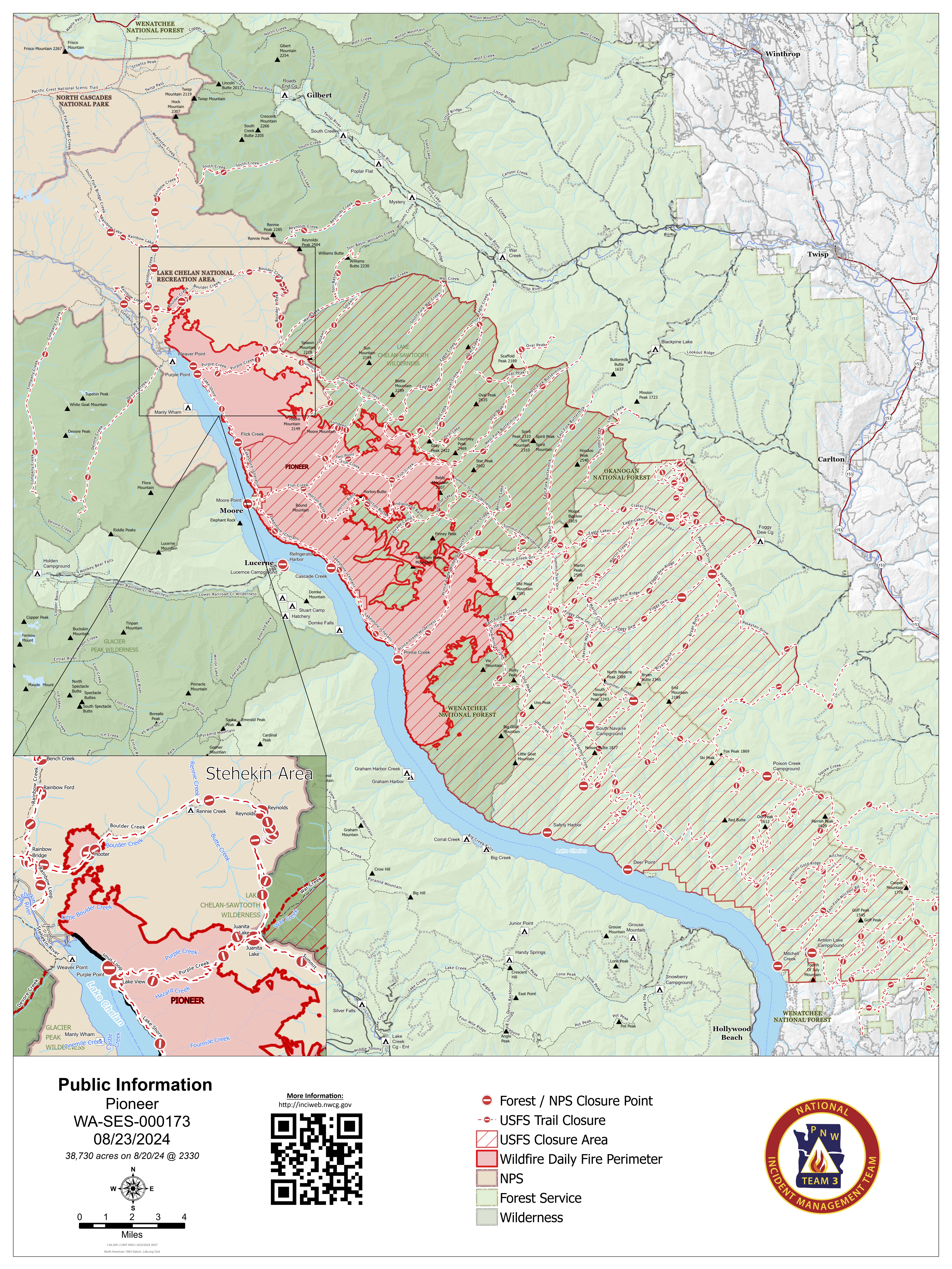
Actualizacin del icnendio Pioneer 23 de agosto de 2024 08 23 2024
Related Incident:
Publication Type: Announcement
Actualización del icnendio Pioneer
23 de agosto de 2024
Tamaño: 38,730 acres
Fecha de inicio: 8 de junio de 2024
Ubicación: 31 millas al NO de Chelan, WA
Contención: 23%
Personal: 444
Causa: A ser determinada
Recursos asignados: 7 equipos de obreros, 6 helicópteros, 11 camiones de bomberos, 20 tanques de agua, 9 maquinarias pesadas
SITUACIÓN ACTUAL: El incendio Pioneer se mantiene dentro de su misma huella. Los bomberos en Stehekin, continuaron trabajando en la línea de mano de Little Boulder, al neutralizar cualquier foco de calor según fuera necesario. No se pudo ver humo en el área de Boulder Creek y la línea de control de retardante se mantiene en su lugar. Las cuadrillas continuaron astillando la vegetación a lo largo de las carreteras. Al sur del incendio, se está trabajando en las carreteras para reparar los daños causados por el tráfico del incendio. A medida que se cumplen los objetivos, se regresan equipos y recursos del incidente.
Stehekin ahora está abierto a los visitantes después un cambio en los niveles de evacuación ayer. Permanecen muchos peligros relacionados con incendios en el área y los servicios pueden ser limitados o alterados. Además, permanecen cerrados muchos senderos y campamentos debido a estos peligros. Los visitantes deben confirmar los servicios que están disponibles antes de viajar.
ACTIVIDADES DE HOY: En Stehekin, continuará el patrullaje de las líneas de mano y la línea de control en Little Boulder y el astillado de escombros de vegetación. Se ha contenido el lado del lago y las cuadrillas trabajan para reparar el cortafuegos en esa área, al remover la berma y la capa de manta sobre la línea construida. No se ha desplazado más el extremos sur del incendio en el último mes, lo que aumenta la confianza de que el fuego continuará manteniéndose dentro de su huella actual. Se comenzarán a remover unas 5 millas de manguera de la línea de contingencia de Nelson Butte al sur del incendio; sin embargo, permanecerá en su lugar el sistema de mangueras en la línea de contingencia de Coyote Ridge. Los recursos asignados al incendio Pioneer continúan disponibles para el ataque inicial de cualquier fuego nuevo en caso de que surja la necesidad.
CLIMA: Es probable que haya lluvia en el incendio Pioneer comenzando esta tarde hasta mañana por la mañana. Las temperaturas estarán entre los 70 y los 70 grados con ráfagas de viento lago arriba.
EVACUACIONES: A partir del 22 de agosto de 2024l Departamento de gestión de emergencias del condado de Chelan redujo los niveles de evacuación para el área de los incendios Pioneer y Stehekin. Para ver los niveles de evacuación actuales, visite la página de Facebook del Departmanto de gestión de emergencias del condado de Chelan en facebook.com/CCSOEM o vea el https://chelangis.maps.arcgis.com/apps/instant/media/index.html?appid=ca1e19e4123b4002a9fb176b25434e03/.
CIERRES: Permanecen cerrados muchos senderos y campamentos. Antes de viajar a estas zonas consulta los cierres actuales para el Parque Nacional de las Cascadas del Norte en: https://www.nps.gov/noca/index.htm y el Bosque Nacional de Okanogan-Wenatchee: https://www.fs.usda.gov/alerts/okawen/alerts-notices. Las fogatas están prohibidas. El sendero Pacific Crest Trail está cerrado en áreas de Washington debido a varios incendios forestales. Para obtener más información, visite: closures.pcta.org/. Hay una Restricción Temporal de Vuelo (TFR, por sus siglas en inglés) sobre el incendio: tfr.faa.gov/save_pages/detail_4_2248.html. La actividad no autorizada con drones está prohibida por la TFR.
InciWeb: https://inciweb.wildfire.gov/incident-information/wases-pioneer
Facebook: https://www.facebook.com/profile.php?id=61560760893080
Línea de información sobre el incendio: 541-861-5808, de 8 AM a 8 PM
Correo electrónico: 2024.pioneer@firenet.gov
Wapiti Fire Update Friday 08 23 2024
Related Incident:
Publication Type: News
Incident Commander: Rick Connell, Northern Rockies Complex Incident Management Team 5
Location: 2 miles southwest of Grandjean, ID
Start Date: 07/24/2024
Cause: Lightning
Size: 35,631 acres
Completion/Containment: 10%
263 Total Personnel; 5 hotshot crews; 2 type 2 hand crews; 19 Engines; 1 bulldozer; 1 water tender; 1 Skidgen.
KEY MESSAGE:
For Custer County, currently notification zone 1 is in “GO” status. Please visit Custer County Sheriff’s Facebook page for a map of the zones. Hwy 21 will be closed so the evacuation route will be Hwy 21 North to Stanley and Hwy 75. An emergency operation center is located behind the Stanley City Hall for more information. At this time the City of Stanley and all of Zone 2 will remain in the Ready status.
A Red Flag warning continues today. The Wapiti Fire has seen extreme fire behavior and has seen active growth to the north toward the Stanley Lake area. For residents in the Stanley Lake and HWY 75 area, please utilize your local Custer County notification system and follow instructions of emergency responders. Hwy 21 is closed east of Lowman from the Warms Springs Airstrip Road to Stanley (MP 92 to 130) due to wildfire activity from the Wapiti Fire. There is no direct public access from the highway to surrounding areas including Grandjean, Bull Trout, Cape Horn, Boundary Creek, or Seafoam. Traffic to/from the Stanley area can use Hwy 75 as an alternate route. No estimate for Hwy 21 reopening is available currently. The Boise, Salmon-Challis and Sawtooth National Forests have issued an updated closure area today.
The Wapiti Fire information phone number has changed to 208-593-7132, and the Middle Fork Complex will retain the phone number for Bulldog and Nellie Fires at 208-992-3045. Saturday morning at 6 am the Rocky Mountain Complex Incident Management Team 1 will assume command of the Wapiti Fire and the contact information will remain the same as today. The Bull Trout Fire transitioned back to the Boise National Forest today.
CURRENT STATUS/PLANNED ACTIONS:
Yesterday, crews were able to access Grandjean and Hanging Valley areas to continue securing around structures throughout the night. Fire activity moved into Wolf Creek drainage, and toward the Hanging Valley Community. Firefighters held fire line around the community through strategic firing operations and operated sprinklers to cool down the areas around structures.
Today crews will assess the Warm Springs area to inventory structures and hazards. North and northeast of the fire, crews have been working in the wildland urban interface to identify hazards such as fuel tanks and firewood piled near structures. Firefighters will use these assessments to develop the best locations to place fireline, hoses, and sprinklers to support wildland fire actions. Crews thinned and cleared vegetation around Stanley Creek area and will continue similar actions in the Iron and Goat Creek communities today. Firefighters will install pumps, hoses and sprinklers around the improved areas in the wildland urban interface today. Crews are working 24 hours a day, utilizing helicopters and fixed wing aircraft to cool down hot spots during the day. Firefighters continue to work in extreme fire weather conditions and are providing for public and firefighter safety by moving public out of areas threatened by the fire.
WEATHER AND FIRE BEHAVIOR:
A Red Flag Warning is in effect again today for low humidity and gusty south winds ahead of an approaching cold front. The inversion will likely lift earlier in the day, possibly as soon as 11 am. When the inversion lifts, south winds will increase to 5-12 mph and may become erratic with gusts up to 40 mph. Relative Humidities will fall to critical levels through mid-evening. Forecasted weather creates a potential for extreme fire behavior with active spread, group torching and spotting up to 5 miles. South/southwest winds will push the fire north.
CLOSURES, RESTRICTIONS, AND EVACUATIONS:
Custer county utilizes ready set go, Red Alert system – For Custer County Text CUSTER to 99411 to enroll in CodeRED (click here) or enroll online at https: /public.coderedweb.com/CNE/BF28E45537FF to receive updates through Integrated Public Alert and Warning System (IPAWS) set your phones to receive alerts by going into settings and then Notifications and turning on your Emergency Alerts. Custer County Sheriff's Facebook Page Link (click on for updates and Important Information)
Hanging Valley, Summer Homes and the Sawtooth Lodge remain in evacuation. An area closure order issued by the Sawtooth and Boise National Forests (Closure #0402-05-95) is effective as of August 22, 2024. This Order is for public and firefighter safety during fire suppression efforts of the Wapiti Fire. For Boise County, Evacuation information will be posted on the Boise County Sheriff’s Office Facebook page.
For closure information, please visit Boise National Forest’s website – Alerts & Closures. Or visit the fire’s InciWeb page. Smoke will be visible and could impact roadways, please follow the instructions of emergency responders and drive safely.
The Boise National Forest, Idaho Department of Lands, and Bureau of Land Management are in Stage 1 fire restrictions on state, endowment, private and federal lands within the West Central Mountains Fire Restrictions Zone. For more information on the restrictions and a map visit:
https://www.idl.idaho.gov/fire-management/fire-restrictions-finder/
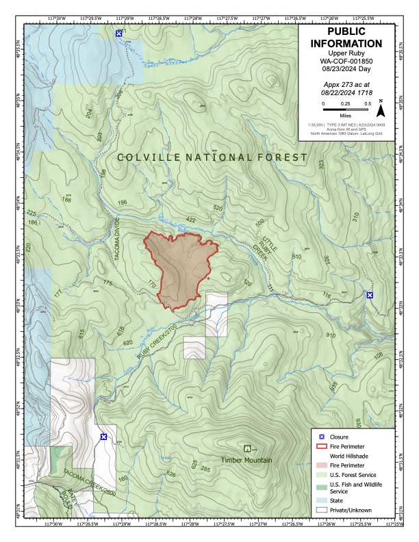
Upper Ruby Fire Daily Update 08 23 2024
Related Incident:
Publication Type: News
Upper Ruby Fire Daily Update August 23, 2024
Quick Facts:
Fire Perimeter: approx. 273 acres
Initial Start: 08/20/24
Location: About 10 mi. southwest of Ione, WA
Hazards: Timber snags, bees, soft road shoulders and narrow roads
Values at Risk: Private residences, ongoing timber sales
Cause: Undetermined
Containment: 0%
Personnel: approximately 300
Structures destroyed: 0
Evacuations: None
Road Closures: Ruby Creek Road (4 miles in from Hwy 20), Tacoma Creek Rd (about 11 miles west of Hwy 20), and Tacoma Divide Road (about 4 miles south of Hwy 20)
Ione, WA –
PUBLIC AND FIREFIGHTER SAFETY IS THE NUMBER ONE PRIORITY.
The Upper Ruby Fire is in central Pend Oreille County about 10 air miles southwest of Ione, WA. It is burning in fuels remaining on the ground following logging activities and in heavily forested areas.
Yesterday, firefighters used heavy equipment and hand tools to build fireline. Air resources and ground crews worked in tandem to construct direct line. Aerial resources dropped water and retardant along the western flank for most of the day to cool areas where crews and equipment were constructing direct fireline. Winds from the east caused embers to ignite spot fires up to 1/8 mile away from the burning edge of the fire. Firefighters were aided by aerial heat detection capabilities that identified the exact location of spot fires as small as a coffee cup. All 9 detected spot fires were extinguished.
On the north flank, the terrain is less suited to heavy equipment and hand crews were able to construct fireline for much of the distance from the western to eastern flank along the slope above Ruby Creek.
Dozer-line construction, aided by feller-bunchers (to clear the thick trees), extended the eastern flank control line that was started during initial attack on Tuesday. Firefighters ignited small areas of fuels to bring the burned area up to the constructed fireline. Firefighting efforts continue to hold the southern flank, keeping fire from private property.
Fire-weakened and standing dead trees (snags), and a very high population of ground nesting bees, pose hazards to firefighters.
Weather today will be partly cloudy with predicted light winds from the east shifting southerly in the afternoon. A slight chance of wetting rain showers today increases for Friday night. Some thunderstorms with gusty winds up to 30 mph may pass over the fire area.
Facebook: https://www.facebook.com/newfireinfo
Phone: 509-671-0625 (hours 8 am – 8 pm)
