
Six Mile and Stranger Creek II Fires FINAL Daily Update 08 24 2024
Related Incident: Six MileStranger Creek II
Publication Type: News
Six Mile and Stranger Creek II Fires FINALDaily Update
August 24, 2024
Quick Facts: Six Mile
Size: 113 Acres Start Date: August 18th, 2024 Cause: Lightning
Location: Two miles east of Nine Mile Hellgate Road, near the head of Cottonwood Creek
Containment: 90% Personnel: 25 Fire Strategy: Full suppression
Resources Assigned: 2 engines
The Six Mile Fire was initiated by lightning and is located approximately 26 miles southwest of Inchelium and is burning in the Williams Flat fire footprint from 2019. Yesterday crews conducted patrol of the fire and review of the snags to ensure containment for the fire. Heavy equipment was utilized to rehabilitate non-primary line suppression efforts, such as dozer lines and staging areas. The spike camp was dismantled and crews returned to ICP to be demobilized and returned to local districts or reassigned to nearby fires. Six Mile is anticipated to be returned to local district on August 25th, 2024.
Quick Facts: Stranger Creek II Fire
Size: 66 Acres Start Date: August 18th, 2024 Cause: Lightning
Location: ¼ mile east/southeast of South Twin Lake
Containment: 90% Personnel: 79 Fire Strategy: Full suppression
Resources Assigned: 3 hand crews, 3 engines, 3 water tenders, 1 heavy equipment
The Stranger Creek II Fire was initiated by lightning and is located approximately 7 miles southwest of Inchelium and 1 mile east of Twin Lakes. Yesterday crews continued to work into the interior, searching for remaining hotspots over 150 feet into the interior of the fire. Crews dismantled hose lays and heavy equipment was brought in to help with rehabilitation on non-primary lines. Crews will continue with rehabilitation and patrol of the fire, with anticipation command returning to local district on August 25th, 2024.
We would like to thank the communities of Inchelium and Twin Lakes for their support of our staff and crews for the success in suppression of these fires!
Closures: Inchelium Highway in front of Inchelium Community Center will remain closed on August 24th, but should reopen after fire camp is demobilized on August 25th.
Weather and Smoke: An upper level area of low pressure will continue to influence the fire area with below normal temperatures, higher humidities, and potential for rain showers Saturday. As the upper level low moves to the east the likelihood of a dry forecast with a decrease in clouds coupled with a slight warming trend increases into the early part of the workweek.
Boise Fire Update August 24 2024 08 24 2024
Related Incident: 2024 Boise Fire
Publication Type: News
Headlines
- The public meeting planned to be held at Forks of Salmon Community Club today has been cancelled due to weather, additionally ICP will be moving to Etna today resulting in schedule challenges. California Team 11 will schedule a new meeting time and date in the near future.
- California Team 11 (Fogle) has arrived to the Boise Fire and will be shadowing with California Team 10 today. California Team 11 will take command of the fire tomorrow, Sunday, August 26, at 7 a.m.
- Traffic control is in place along the Salmon River Road between Butler Flat and Nordheimer Flat for the safety of firefighters and residents. Expect up to 30-minute delays.
- Fire information phone: (707) 572-4860 or email at 2024.Boise@firenet.gov
- Get all your Boise Fire information in one mobile-friendly place! https://linktr.ee/2024boisefiresrf
- Evacuations are in place for the Boise Fire for residents near the fire area in Humboldt County. For the most current evacuation information please visit the Boise Fire linktree or visit--
- Humboldt County: https://humboldtgov.org/356/Office-of-Emergency-Services
- Siskiyou County: https://www.co.siskiyou.ca.us/emergencyservices
Leader’s Intent: The Boise Fire is being managed with a full suppression strategy.
Operational Update: Yesterday, fire activity moderated due to rain over the fire area. Crews were held from the fire line yesterday due to weather. Today, roads must be inspected for hazards before crews can safely return to engaging in containment efforts.
Today, crews plan to continue to patrol the west side of the fire and backhaul materials and equipment. On the eastside of the fire, firefighters will continue to prep containment lines.
The Incident Command Post will be moving to Etna today. Base camps will remain in Aikens Creek and Forks of Salmon to continue to keep firefighters within reasonable travel time and provide coverage to both sides of the fire area.
Yesterday, some crews were released from the incident as conditions continue to improve. Significant resources will remain assigned to the Boise Fire as there is still a considerable amount of uncontained fire edge within indirect lines. With warm, dry conditions ahead, fire managers will be monitoring carefully for activity as vegetation is expected to return quickly to critically dry levels.
Weather and Fire Behavior: Wetting rain is expected to continue over the fire area until this afternoon. This system is expected to pass out of the area by the end of the weekend with a return to much more seasonable conditions on Monday.
Park Fire Morning Update 08 24 2024
Related Incident: Park Fire
Publication Type: News
Park Fire Morning Update for August 24 is posted on the Park Fire Status Update Page
Limepoint Fire Daily Update August 24 2024 08 24 2024
Related Incident: Limepoint Fire
Publication Type: News
Limepoint Fire
Saturday, August 24, 2024
Contacts for Fire Information: 208-992-3032 or
2024.limepoint@firenet.gov
https://inciweb.wildfire.gov/incident-information/idpaf-limepoint-fire
https://www.facebook.com/payettenationalforest/
The Limepoint Fire is holding at its current size and its percentage of containment has improved. Lines are being contained in the Boulder Creek area. Containment lines on the northeastern edge are still being improved with mop up, suppression repair, and hazard tree removal.
Heavy equipment continued road grading and suppression repair in the Bear and Huntley Gulch areas. Logging equipment is pulling out trees from when dozers put in a contingency line in Huntley Gulch during the early part of the Limepoint Fire. These will be decked and assessed to determine if they can be salvaged as forest products.
While cooler and wetter weather is forecasted for the fire area this weekend, only light precipitation is expected before hot and dry conditions rebound next week. The incredibly active fire behavior elsewhere in Central Idaho and throughout the Great Basin have fire managers focused on fully containing Limepoint.
On Saturday morning, Great Basin Team 4 will transfer command of the Limepoint Fire to Nevada Team 5, a Type 3 incident management team. Thank you to the excellent work and hand off from Great Basin Team 4. The Incident Command Post that has been at the Council Fairgrounds is moving to the Seven Devils spike camp near the community of Bear.
Evacuations: Cuprum remains at a Level 1 (READY) evacuation level and Bear evacuations are lifted completely. There is still a lot of work being done in the fire area so, for your safety and the safety of firefighters, please stay away until closures are fully lifted. Only residents and property owners are allowed in the area until further notice.
Closures: The Forest Closure Order issued by the Payette National Forest to protect public safety near the fire area remains in effect. For more information about the closure, visit https://inciweb.wildfire.gov/incident-information/idpaf-limepoint-fire
Restrictions: Stage 1 Fire Restrictions remain in effect for the Payette National Forest and all state, private and BLM lands in the fire area. Under these restrictions, campfires are allowed only in recreation sites within metal fire pits. Fires of any kind are not allowed in any dispersed camping areas.
Cottage GroveLane 1 Fire Update 08 24 2024
Related Incident: Lane 1 Fire
Publication Type: News
Rain showers reduce fire behavior, team transitions management of Lane 1
COTTAGE GROVE, Ore. – Rain showers once again dampened fire behavior on the Cottage Grove – Lane 1 Fire, wetting fuels. Several waves of rain crossed over the area, with nearly a half inch of rain falling on the fire in the last 24 hours. Firefighters have reached 300 feet of cold black across much of the perimeter of the fire. A few pockets have been identified where the fire burned a mosaic pattern because of terrain and fuel conditions. These areas have been more challenging to mop up for firefighters.
Today Oregon Department of Forestry Team 1 is transitioning management of the east side of the fire to Alaska Team 1 and the west side of the fire to a Type 3 organization staffed by ODF South Cascade District and Douglas Forest Protective Association. The teams were in-briefed Friday evening and transfer of command will occur today at 6 p.m.
Park Fire Evening Update 08 23 2024
Related Incident: Park Fire
Publication Type: News
Park Fire Evening Update for August 23 is posted on the Park Fire Status Update Page
FOREST SERVICE Borel PostFire BAER Assessment Report Summary Released 08 30 2024
Related Incident: Borel Post-Fire BAER
Publication Type: News
FOREST SERVICE: Borel Post-Fire BAER Assessment Report Summary Released
The Forest Service—Sequoia National Forest completed a Burned Area Emergency Response (BAER) post-fire assessment of the Borel burned area and affected watersheds to determine their response, soil conditions, potential threats, and recommended BAER emergency stabilization measures and actions on National Forest System (NFS) lands. BAER emergency treatments and activities are designed to decrease possible impacts to critical values from the burned areas during rainstorm events such as: human life and safety, property, critical natural resources, and cultural resources.
NOTE: Attached below as “Related Information” is a PDF documents called “Borel Post-Fire BAER Assessment Report Summary_PUBLIC”.
BAER SAFETY MESSAGE: Everyone near and downstream from the burned areas should remain alert and stay updated on weather conditions that may result in heavy rains and increased water runoff. Flash flooding may occur quickly during heavy rain events--be prepared to act. Current weather and emergency notifications can be found at the National Weather Service website: www.weather.gov/hnx/.
###
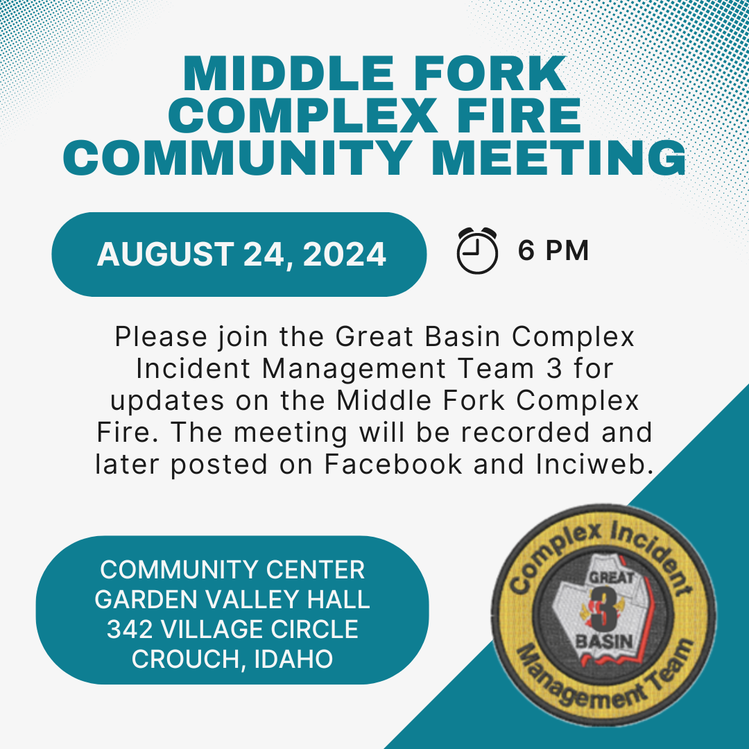
Middle Fork Complex Fire Community Meeting on Saturday August 24 08 23 2024
Related Incident:
Publication Type: Announcement
Join us in person at 6:00pm on Saturday, August 24, 2024 at the Community Center Garden Valley Hall at 342 Village Circle Crouch, Idaho for a community meeting on the Middle Fork Complex Fire. We will provide a recording here, and on our Facebook page for those who cannot make it in person.
Cottage GroveLane 1 Fire Update 08 23 2024
Related Incident: Lane 1 Fire
Publication Type: News
Rain returns to the forecast, aiding firefighters in the last stages of mop up
COTTAGE GROVE, Ore. – Cooler temperatures and rain showers have returned to the forecast overnight, naturally helping firefighters engaged on the Cottage Grove – Lane 1 Fire in the last efforts of mop-up operations. Overnight, a quarter inch of rain was recorded over the fire. Containment has increased once again, now sitting at 85%. As resources continue to find and extinguish remaining hotspots, this number will rise.
Thunderstorms also return to the forecast today, with slight chances for isolated storms. Firefighters engaged in mop-up efforts will be ready to respond to any new lightning-caused fire starts in the immediate area or help local districts beyond.
Repair work continues to remain the focus on the fire now, as resources create water bars to prevent erosion, particularly for when consistent rain returns in the fall and winter. Firefighters are also working to return areas that have been impacted by suppression efforts to a more natural state on federal lands on the east side of the incident. This will continue for the next couple of weeks.
As work progresses on the line, Oregon Department of Forestry Team 1 personnel are engaged in the process of transitioning the incident to Alaska Team 1 on the east side of the fire, and a Type 3 local team of ODF South Cascade and Douglas Forest Protective Association staff on the west. Members from both of these new teams are arriving today and will be in-briefed on the current status of the incident tonight at 5 p.m.
This meeting will kick off the transition of the incident; personnel across all three teams will work together tomorrow to exchange information, ensuring a smooth transition to the incoming teams. The official transfer of command will take place Saturday night at 6 p.m.
The Lane County Waste Management Sharp's Creek Transfer site is open on its regular schedule once again. More information is available here: https://www.lanecounty.org/government/county_departments/public_works/waste_management
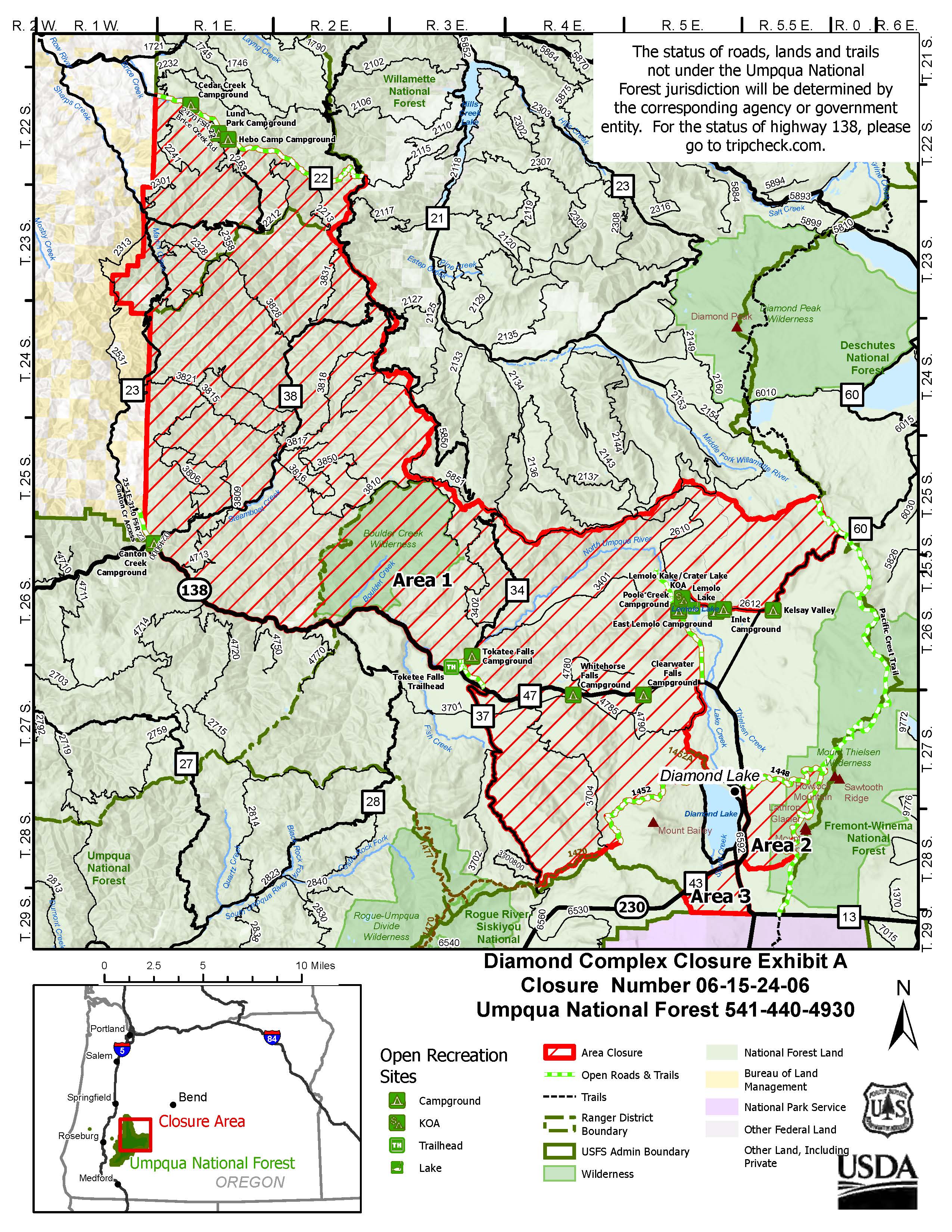
Closures: Due to wildfires, the Umpqua National Forest has issued a closure to provide for public safety. The closure order and map can be found here: https://www.fs.usda.gov/alerts/umpqua/alerts-notices.
The Bureau of Land Management has issued the following emergency closure for Lane County: https://www.blm.gov/announcement/bureau-land-management-expands-emergency-fire-closure-due-cottage-grove-lane-1-fire
The following County roads are closed except to owners of private lands accessed from these roads: Brice Creek Road east of Umpqua National Forest Boundary, all of Sharps Creek Road.
Evacuations: A “Level 3” evacuation notice is in effect for the Bohemia Mining District and Fairview Peak. An evacuation map is available at: www.LaneCountyOR.gov/Lane1Fire.
Temporary Flight Restriction (TFR): A “TFR” is in place at an altitude from the surface up to and including 8500 feet, daily (24 hours) until further notice. Complete information is available at https://tfr.faa.gov/save_pages/detail_4_5180.html. Flying a drone near or around a wildfire compromises the safety of pilots and interferes with firefighting efforts.
Fire Restrictions: Umpqua National Forest restrictions can be found online – https://www.fs.usda.gov/main/umpqua/fire
Bureau of Land Management can be found online – Fire Restrictions - Oregon-Washington Bureau of Land Management (blm.gov)
Oregon Department of Forestry restrictions can be found here – https://www.oregon.gov/odf/fire/pages/restrictions.aspx
Douglas Forest Protective Association restrictions can be found here – https://www.dfpa.net/public-fire-restrictions