
Wapiti Fire Daily Update Saturday August 24 08 24 2024
Related Incident:
Publication Type: News
Wapiti Fire Update
Saturday, August 24, 2024 – 9:00 a.m.
Rocky Mountain Complex Incident Management Team 1
Dan Dallas, Incident Commander
Information Phone: 208-593-7132 Hours: 8 a.m. to 8 p.m.
Email: 2024.wapiti@firenet.gov
InciWeb:https://inciweb.wildfire.gov/incident-information/idbof-wapiti-fire
Facebook:https://www.facebook.com/wapitifireinfo2024/
Information Linktree:https://linktr.ee/WapitiFireInfo2024
Special Notes: Rocky Mountain Complex Incident Management Team 1 (RM CIMT1) assumed management of the Wapiti Fire at 6:00 am this morning. We thank the outgoing Northern Rockies CIMT5, hosting agencies, cooperators, and the many firefighters on the incident for a smooth and comprehensive transition to our team.
State Highway 21 is closed from east of Lowman to Stanley (MP84 to MP130) due to wildfire activity. The closure is necessary for public safety and to provide safe conditions for firefighters working along the highway.
A community meeting is scheduled for tomorrow, August 25, 2024 at 6 p.m. at the Stanley Community Building in Stanley, ID.
Current Situation: Multiple days of Red Flag Warnings and extreme burning conditions have been a challenge for firefighters on the Wapiti Fire. It is estimated that the fire has grown to over 45,000 acres over the period, expanding most significantly on the northeastern corner across Stanley Lake and crossing State Highway 21 to the north. It has also grown westward and crossed Highway 21 on the fire’s west side, as well as moving towards the Warm Springs area east of Lowman. Crews, engines, heavy equipment, and aircraft are working to secure structures and other values at risk through point protection strategies throughout the fire affected area.
Crews have been working on structure assessments and implementing point protection tactics along the Highway 21 corridor from the northern extension of the fire south to Stanley. This includes noting hazards such as fuel tanks and flammable vegetation near structures, as well as deploying hoses, pumps, and sprinkler systems around improvements in the wildland-urban interface. Today, a Structure Protection Group East has been established to continue and expand this work.
In the interior of the fire, around Grandjean and along the 524 Road, engines and crews continue 24 hour a day work to mop up around structures and secure the area to prevent any potential for reburns to occur.
Crews on the west side of the fire are also working 24 hours a day to protect structures from the fire’s westward advance. Fireline around structures and hoses, pumps, and sprinkler systems have been deployed. A Structure Protection Group West has been established today to continue and expand this work. Structure assessments are ongoing in the Warm Springs area. Further north, fire managers are assessing the fire’s recent advancement across Highway 21 and are developing suppression strategies for containing that portion of the fire.
Weather, Fuels, and Fire Behavior:
Red Flag Warning conditions existed yesterday, leading to extreme fire behavior. Afternoon SSW winds over the fire were sustained at 40-45 mph, and relative humidity was 15-20%. A cold front moved in from the SW overnight, bringing increasing humidity and cloud cover with a possibility of scattered showers over the next 24 hours. Precipitation may average about 0.10 inch, which could moderate fire behavior for a day
or two. Skies will clear Sunday night and nighttime temperatures will drop to around freezing.
Evacuations:
For evacuation information on the Wapiti Fire, please see the Custer County Sheriff’s Facebook page at https://www.facebook.com/p/Custer-County-Sheriff-Idaho-61558947312289/ and the Boise County Sheriff’s Facebook page at https://www.facebook.com/boisecountysheriff/ .
Red Cross is set up in the Stanley Community Center to assist fire evacuees.
To sign up for Custer County CodeRED emergency notifications, text CUSTER to 99411 or enroll online at https://public.coderedweb.com/CNE/BF28E45537FF .
Closures and Fire Restrictions:
State Highway 21 is closed from MP84 to MP130 for public and firefighter safety.
A Wapiti Fire Area Closure / Forest Order: 0402-05-95 for portions of the Boise, Sawtooth, and Salmon-Chalis National Forests can be found at this site: https://www.fs.usda.gov/alerts/boise/alerts-notices .
Boise National Forest Stage 1 Fire Restrictions / Forest Order: 0402-00-63 can be found at this site: https://www.fs.usda.gov/alerts/boise/alerts-notices .
Sawtooth National Forest Stage 1 Fire Restrictions / Forest Order 0414-00-044 can be found at this site: https://www.fs.usda.gov/alerts/sawtooth/alerts-notices .
Fire restrictions on state and private lands may be found at this site: https://www.idl.idaho.gov/fire-management/fire-restrictions-finder/ .
A Temporary Flight Restriction is in place over the Wapiti Fire. Wildfires are a no-fly zone for unauthorized aircraft, including drones. If you fly, we can’t. For more information, visit http://knowbeforeyoufly.org.
Wapiti Fire Statistics:
Size: over 45,000 acres
Containment: 10%
Total Personnel: 420
Location: Grandjean, ID
Reported: July 24, 2024
Cause: lightning
For More Information:
Information Phone: 208-593-7132
Email: 2024.wapiti@firenet.gov
InciWeb: https://inciweb.wildfire.gov/incident-information/idbof-wapiti-fire
Facebook: https://www.facebook.com/wapitifireinfo2024/
Linktree: https://linktr.ee/WapitiFireInfo2024
Middle Fork Complex Update for Saturday 08 24 2024
Related Incident:
Publication Type: News
Middle Fork Complex Update
August 24, 2024
Fire Size: 41,519 Acres
Completion: 5%
Resources: Helicopters: 5 | Engines: 18 | Hand crews: 10 | Total Personnel 546
Location: Approximately nine miles east of Garden Valley, ID
Started: August 8, 2024
Cause: Naturally Caused, Lightning
Management: Great Basin Complex Incident Management Team 3
Community Meeting
A community meeting will be held today at 6 p.m. at the Garden Valley Hall, 342 Village Circle, Crouch, Idaho. Incident Commander Brett Waters, key team members, and representatives from the Boise National Forest will provide updates on the Middle Fork Complex Fire and address any questions.
Weather and Fire Behavior
A low-pressure system will provide relief from red flag weather, bringing mostly cloudy skies, cooler temperatures, much higher humidities, lighter winds, and scattered light showers to the fire areas. As a result, these conditions will moderate fire behavior at all elevations, limiting rates of fire spread.
Operations
A red flag warning (high temperatures, gusty winds, low humidity) was in place yesterday and contributed to fire growth on both the Nellie and Bulldog fires. Crews are actively engaged in efforts along FS Road 698 to contain the Bulldog Fire, focusing on the western edge. Structure protection measures in addition to the placement of pumps, hand lines, and dozer lines, have been established along the southwestern perimeter. The fire experienced moderate growth on the northern and southeastern sides.
The Nellie Fire was most active on both the northern and southern edges yesterday. No structures have been damaged or destroyed, and infrastructure at the Deadwood Reservoir remains secure. Ongoing efforts are focused on protecting homes, the Scott Mountain and Deadwood Lookouts, the communication tower, and structures along Highway 17 corridor with protection measures implemented on the southern edge of the fire.
Several spot fires became established on the northwestern side of Deadwood Reservoir during the last few days of dry, hot, and windy weather. Crews are actively working to contain them. Additionally, contingency lines are being explored along the Deadwood Reservoir, with the goal of keeping the Nellie Fire within previously burned areas. Power lines along Highway 17 were de-energized yesterday to ensure safe operations and have since been re-energized.
Closures
The Boise National Forest has issued Order Number 0402-06-59, effective August 23, 2024. For additional details, please visit the Boise National Forest website at https://www.fs.usda.gov/alerts/boise/alerts-notices. Hwy 21 is closed from the Sour Dough Lodge in Lowman to Stanley (MP 84 to 130) due to wildfire activity. Only local traffic is permitted between the Sour Dough and Warm Springs Airstrip. Visit https://511.idaho.gov/ for more info.
Temporary Flight Restrictions (TFR): A TFR is issued over the fire area. It is illegal for members of the public to fly drones over or near wildfires because of the potential for accidents and disruption of suppression operations.
Facebook
https://www.facebook.com/people/Middle-Fork-Complex-Fire-Boise-National-Forest/61565022204468/
Information Line
208-992-3045 (8am – 8pm)
Email
2024.middleforkcomplex@firenet.gov
Pioneer Fire Update 08 24 2024
Related Incident:
Publication Type: News
Pioneer Fire Update
August 24, 2024
Quick Facts
Size: 38,735 acres
Start Date: June 8, 2024
Location: 31 miles NW of Chelan, WA
Containment: 23%
Personnel: 448
Cause: Under investigation
Resources Assigned: 7 crews, 6 helicopters, 12 engines, 20 water tenders, 9 heavy equipment
CURRENT SITUATION: Rain fell over the fire area yesterday and into the evening. Fire activity is minimal, mostly smoldering in the Boulder Creek and Little Boulder Creek drainages. There has been little to no growth over the last week and the fire continues to hold below the Boulder Creek check line. Yesterday crews patrolled the hand line along Little Boulder Creek and Boulder Ridge and also monitored the area for heat using an unmanned aircraft system (UAS). Work to clear roadsides of vegetation piles continued in Stehekin and firefighters began to back haul excess equipment along the lakeshore. South of the fire near Manson crews continued to haul vegetation debris and repair roads damaged by fire-related traffic.
Stehekin is now open to visitors. Many fire-related hazards remain in the area and services may be limited or altered. Additionally, many trails and campgrounds remain closed due to these hazards. Visitors should confirm available services before traveling.
TODAY’S ACTIVITIES: In Stehekin, firefighters will continue patrolling the Boulder Creek and Little Boulder Creek area to check for any heat or fire activity. Crews will also work to finish remaining chipping of vegetation debris as weather conditions allow. Along the lakeshore and south of the fire, backhaul of equipment that is no longer needed will continue. Firefighters continue to be available for initial attack of new fires.
WEATHER: Fall-like conditions will continue today, with rain showers lingering into the afternoon. Expect partly cloudy skies with high temperatures in the 50s.
EVACUATIONS: Chelan County emergency management downgraded evacuation levels for the Pioneer Fire and Stehekin area, effective August 22, 2024. To view the current evacuation levels, please visit the Chelan County Emergency Management Facebook page at facebook.com/CCSOEM or view the https://chelangis.maps.arcgis.com/apps/instant/media/index.html?appid=ca1e19e4123b4002a9fb176b25434e03/.
CLOSURES: Many trails and campgrounds remain closed. Check the current closures for the North Cascades National Park: https://www.nps.gov/noca/index.htm and Okanogan-Wenatchee National Forest: https://www.fs.usda.gov/alerts/okawen/alerts-notices before traveling to these areas. Campfires are prohibited. The Pacific Crest Trail is closed in areas across Washington due to multiple wildfires. For more information, please visit: closures.pcta.org/. There is a Temporary Flight Restriction (TFR) in place over the fire: tfr.faa.gov/save_pages/detail_4_2248.html. Unauthorized drone activity is prohibited under the TFR.
InciWeb: https://inciweb.wildfire.gov/incident-information/wases-pioneer
Facebook: https://www.facebook.com/profile.php?id=61560760893080
Fire Information Line: 541-861-5808, 8 a.m. to 8 p.m.
Email: 2024.pioneer@firenet.gov
Diamond Complex and Middle Fork Daily Update 08 24 2024
Related Incident: Middle Fork Fire
Publication Type: News
Our primary mission on the Diamond Complex and Middle Fork Fire is to serve the public with dedication and compassion. With your safety and the safety of our firefighters in mind, we are committed to addressing the needs and concerns of your communities by managing and controlling the fires to keep your forests, parks, and natural areas safe and enjoyable. Using safe and aggressive firefighting suppression methods our goal is to help you return to enjoying the outdoors.
The Diamond Complex in the Umpqua National Forest consists of 30 lightning-caused fires totaling approximately 11,152 acres and is 62% contained. Twenty-five of the original 30 fires in the Diamond Complex are now 100 percent contained.
The Middle Fork Fire in the northwest corner of Crater Lake National Park is 5,280 acres and is 0% contained. The fire is primarily burning within the 2015 National Creek and 2017 Spruce Lake fire scars. Throughout the fire area there is an extreme hazard to firefighters due to falling dead standing trees remaining from the 2015 and 2017 fires.
Rains yesterday temporarily reduced fire behavior and allowed crews opportunities to scout for direct suppression opportunities. Today firefighters will continue line construction and are beginning to plan for suppression rehab activities to repair firelines along cold burned areas. Initial Attack firefighters are also standing by to respond to new fires caused by lightning strikes as needed.
OPERATIONS:
Middle Fork Fire: (5,280 acres, 0% contained):
Crews continue to remove heavy timber and vegetation along the 230 Road and at the north entrance to Crater Lake National Park. On the southern side and along the Bald Crater Trail, crews are improving firelines and looking for additional opportunities to safely engage the fire directly. The park remains open.
Diamond Complex Fires:
Pine Bench Fire (North of Hwy 138 near Dry Creek, 3,990 acres, 42% contained):
Hand crews and dozers are working in the lower portion of the fire reinforcing control lines and extinguishing hot spots along the southern edges of the fire. Infrared sensing along the northern edge of the fire is showing few hot spots and reduced fire activity in the Wilderness.
Potter Fire (North of Hwy 138, two miles southeast of Potter Mountain, 3,416 acres, 6% contained):
Crews continue to build dozer lines and hand lines on the east side of the fire into Nancy Creek in the east. On the north side, Hot Shots and Dozer operations are working through steep and dangerous terrain while facing extreme hazards from falling trees. On the southern edge of the fire crews are working to identify opportunities for direct action on the fireline.
Trep Fire (About four miles south of Hwy 138, 545 acres, 0% contained):
Firefighters are working to extinguish hot spots, reinforce control line as needed and hold the fire west of Bear Creek Drainage.
Other fires within the Diamond Complex:
Ooya Fire (North of Hwy 138, one mile northeast of Bird Point, 374 acres, 85% contained): Crews, including National Guard units, continue to patrol and extinguish hot spots.
Loafer Fire (44 acres, 56% contained)
WEATHER AND FIRE BEHAVIOR:
Rainfall totals of 0.4 to 0.8 inches on average fell across the entire complex overnight. There were 4 cloud to ground lightning strikes reported within the complex area. The system responsible for the recent bout of rain will move
east across the region and exit during the day on Saturday. A drying and warming trend will begin Sunday. A return to near and above normal temperatures, including increased fire behavior, is expected next week with no chances for rain on the horizon.
SMOKE OUTLOOK:
For the most up to date information, please visit fire.airnow.gov/
EVACUATIONS:
None. As of August 23, 2024 the Douglas County Sheriff’s Office has lifted evacuation orders for all areas.
FOREST CLOSURE:
On August 21, 2024 the Forest reduced the temporary closure order, allowing increased access to specific roads, trails, and campgrounds that are listed as exemptions in Forest Order 06-15-24-06. For more information visit the Umpqua National Forest website at: https://www.fs.usda.gov/alerts/umpqua/alerts-notices/?aid=88996
The Rogue River-Siskiyou National Forest has issued a closure for the area north and west of Crater Lake National Forest along Highway 230 south to the intersection with Highway 62. See the Closure Order and map at https://www.fs.usda.gov/alerts/rogue-siskiyou/alerts-notices.
PARK CLOSURE:
The North Entrance Road is closed from North Junction to the park boundary at the junction with Highway 138. This closure is necessary to ensure the safety of fire crews and the public. The date for reopening is not known at this time. All other park roads will remain open, except for construction closures on East Rim Drive. Crater Lake National Park remains open and is accessible from Highway 62 on the western and southern routes.
Crater Lake National Park has several closures in effect, closure orders and maps can be found at:
https://www.nps.gov/crla/learn/news/temporary-closure-of-north-entrance-road-continues.htm
REMINDER: The Pacific Crest Trail between the Lightning Springs and Rim Trail Intersections, Bald Crater Loop, Bert Creek and Boundary Springs Trails are closed until further notice due to potentially hazardous conditions created by the Middle Fork Fire. Hikers and bikers may not use the North Entrance Road to enter or leave Crater Lake National Park.
North Willamette Complex Ore and Pyramid Fires Daily Update 08 24 2024
Related Incident: North Willamette Complex
Publication Type: News
Willamette Complex North
Daily Update
2024.WillametteComplex.North@firenet.gov
Information line: 541-208-1262, 8 am to 8 pm
Facebook: facebook.com/OreFireInformation2024 ; https://www.facebook.com/PyramidFireInfo2024/
Inciweb: Willamette Complex North
August 24, 2024
SUPPRESSION OBJECTIVES: The Ore Fire and the Pyramid Fire remain under a full suppression strategy to protect values at risk, including the Middle Santiam Wilderness and private timberlands. Firefighters are using a combination of direct fire line where conditions permit, and indirect fire line where it is necessary to work at a distance from the fire’s edge.
CURRENT SITUATION: Widespread wetting rain over the past 48 hours will transition to isolated showers and cool/wet conditions today. Conditions are presenting challenges, but firefighters are making access where safely possible. A slight warming/drying trend is predicted early next week. Pockets of heat remain within the fire interiors and continue to smolder and produce smoke. The lingering effects of recent moisture will continue to moderate fire behavior and fire spread probability.
Ore Fire: 7 miles Northeast of Blue River, 3,140 acres, 16% contained, 709 total personnel, human caused. Overnight crews continue to patrol and secure containment lines. Day shift crews will scout the viability of direct hand line construction, mop up, and secure containment lines where possible. Contingency resources will work on fuel break improvements, chipping, masticating, and assessing handline construction. Mastication is the process by which machinery is used to cut, chop, and grind vegetation into smaller pieces. A contingency line is a secondary or alternate strategic fire line, which is created as a back up to the primary fire line, based on current needs and conditions.
Pyramid Fire: East of Middle Santiam Wilderness, 1,312 Acres, 88% contained, 228 total personnel, lightning caused. Roadside wood hauling and brush chipping is ongoing, and crews continue to secure containment lines and fortify outlying contingency lines. Firefighters are also working to strengthen existing fire breaks along roads by removing brush and smaller trees to widen a fuel break.
CLOSURES & FIRE RESTRICTIONS UPDATE: Please refer to the Linn County Fire Map for current status. (Please see below).
Area, road, trail, and recreation site closures are in effect on the Willamette National Forest. Specific information is posted at https://www.fs.usda.gov/alerts/willamette/alerts-notices/?aid=61574. Please see Pyramid Fire Area Closure Forest Order and the Ore Fire Area Closure Forest Order.
Due to long term hot and dry conditions, all campfires, charcoal fires, pellet fires, or any other open fires are prohibited, including in developed campgrounds and wilderness areas. Pressurized liquid or gas stoves, lanterns, and heaters that can be switched on and off are allowed. Please see Forest Order 06-18-00-24-27 for additional information.
ROADS: When traveling in the area, please be mindful of firefighters and their vehicles working near roads. Please visit the Oregon Department of Transportation website for current road conditions.
Williams Mine Fire Update 08 24 2024
Related Incident: Williams Mine Fire-GPNF
Publication Type: News
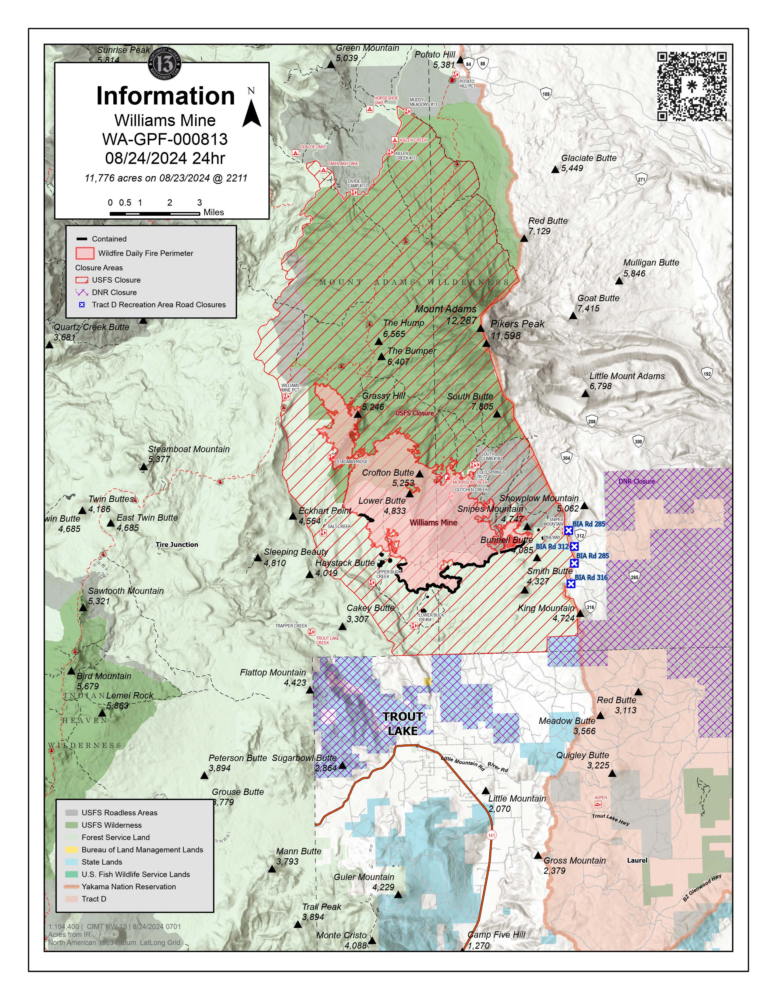
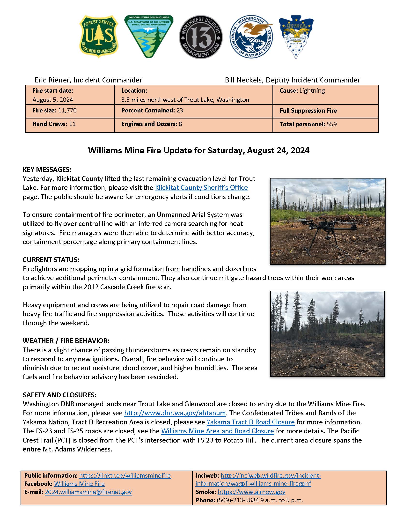
Williams Mine Fire Update for Saturday, August 24, 2024
KEY MESSAGES:
Yesterday, Klickitat County lifted the last remaining evacuation level for Trout Lake. For more information, please visit the Klickitat County Sheriff’s Office page. The public should be aware for emergency alerts if conditions change.
To ensure containment of fire perimeter, an Unmanned Arial System was utilized to fly over control line with an inferred camera searching for heat signatures. Fire managers were then able to determine with better accuracy, containment percentage along primary containment lines.
CURRENT STATUS:
Firefighters are mopping up in a grid formation from handlines and dozerlines to achieve additional perimeter containment. They also continue mitigate hazard trees within their work areas primarily within the 2012 Cascade Creek fire scar.
Heavy equipment and crews are being utilized to repair road damage from heavy fire traffic and fire suppression activities. These activities will continue through the weekend.
WEATHER / FIRE BEHAVIOR:
There is a slight chance of passing thunderstorms as crews remain on standby to respond to any new ignitions. Overall, fire behavior will continue to diminish due to recent moisture, cloud cover, and higher humidities. The area fuels and fire behavior advisory has been rescinded.
SAFETY AND CLOSURES:
Washington DNR managed lands near Trout Lake and Glenwood are closed to entry due to the Williams Mine Fire. For more information, please see http://www.dnr.wa.gov/ahtanum. The Confederated Tribes and Bands of the Yakama Nation, Tract D Recreation Area is closed, please see Yakama Tract D Road Closure for more information. The FS-23 and FS-25 roads are closed, see the Williams Mine Area and Road Closure for more details. The Pacific Crest Trail (PCT) is closed from the PCT's intersection with FS 23 to Potato Hill. The current area closure spans the entire Mt. Adams Wilderness.
West Mountain Complex Daily Update 08 24 2024
Related Incident: Wolf Creek FireBoulder FireDollar Fire
Publication Type: News
QUICK FACTS
Fire Location Size Containment Start Date
Boulder 9 miles SW of Cascade 2,313 acres 44% 7/24/2024
Wolf Creek 5 miles W of Donnelly 1,154 acres 95% 7/24/2024
Snag 11 miles E of Cascade 25,235 acres 3% 8/5/2024
Dollar 18 miles NE of Cascade 2,665 acres 0% 8/5/2024
Goat 11 miles SE of Cascade 1,963 acres 0% 8/5/2024
Cause: Lightning (All Fires)
Total Incident Personnel: 925
Army firefighting soldiers from the 14th Brigade Engineer Battalion, based at Joint Base Lewis-McChord in Washington are currently working on the Boulder Fire and Snag Fire. They are using hoselays to mop-up and helping construct, improve and hold indirect line.
Weather | Anticipated Fire Behavior:
Erratic fire behavior occurred yesterday due to a change in wind speed, direction, and relative humidity. Winds reached 25 to 30 miles per hour, throughout the day, and shifted from the southeast back to the southwest. Low relative humidities of 27 to 28 percent contributed to active fire behavior and the production of smoke. Today, a low-pressure system with moisture will move into the area bringing with it cooler temperatures and a chance of showers in the morning and thunderstorms into the afternoon and evening.
Boulder Fire: https://tinyurl.com/ycdfv3tv
Firefighters continued to secure and hold the control line along the southern and northeastern edge of the fire after they applied direct firing operations to remove burnable vegetation. Containment lines cut off any movement of the fire eastward. Crews will continue to scout and monitor for future firing operations to clean up islands of unburned fuels within the interior of the fire boundary. Mop-up and monitoring will continue to increase the depth of containment lines.
Dollar Fire: https://tinyurl.com/bef6r3tz
Firefighters slowed the northern movement of the fire around the Needles area with direct and indirect firing operations to prevent the fire from advancing further north. The Army crews helped to plumb the lines in preparation for direct firing operations intended to increase and clean up the depth of unavailable fuels, which will enhance the containment efforts. Crews will continue to look for opportunities for direct firing operations when weather and safety permit to help secure and increase overall containment.
Snag Fire: https://tinyurl.com/4k9dk3mu
Firefighters working night shift had to use direct suppression to respond to forty new spot fires associated with the Snag Fire on Thursday evening into early Friday morning. On Friday, dozers installed control lines to contain the spot fires in the southern boundary of the fire’s edge. On the western portion of the fire, they completed firing operations to help reduce burnable vegetation between the Warm Lake Highway and the approaching active flames to slow the movement of the fire in that area. Smoke plumes were visible from Long Valley because of firing operations along the western boundary. Today, crews will continue to evaluate and mitigate hazards along the perimeter of the fire, especially along the Warm Lake Road, as well as continue to maintain, secure, and hold containment lines along all boundaries of the fire.
Wolf Creek Fire: https://tinyurl.com/mcksrfvh
Single and group tree torching occurred on the northern portion of the Wolf Creek Fire where flames remain active. Crews continued to monitor the edge of the fire for any interior hot spots and completed mop up where needed. Additionally, crews continued to complete rehabilitation and repair work along the dozer and handlines around the Little Weiser drainage. Crews will begin transitioning from direct suppression efforts to monitoring, and mopping up to increase the depth of the containment lines around the perimeter of the fire.
Goat Fire: https://tinyurl.com/2h4a3dvr
Fire activity on the Goat Fire increased because of a change in wind direction from Thursday into Friday. Crews will continue to monitor the fire with aerial resources to prevent the fire from impacting and advancing into the Clear Creek drainage area. The flames advancing to the north continue to run into previously burned fuels of the Cascade Complex. Firefighters will continue to evaluate values at risk to the south of the fire in order to minimize impacts.
Other fire information:
Middle Fork Complex (Nellie, Anderson, and Bulldog Fire): https://tinyurl.com/3rhawr5y
Wapiti Fire: https://tinyurl.com/yf7reydj
Bulltrout Fire: https://tinyurl.com/tatwwk5t
SNAG FIRE EVACUATION INFORMATION
The Valley County Sheriff’s Office issued a “ready” evacuation order for Warm Lake residents and the North Shore Lodge at Warm Lake on August 7. The map can be found on Inciweb: https://tinyurl.com/42auxnk8. A second “ready” evacuation order was issued on August 8 for the Horsethief area, including the YMCA Camp, and areas of Scott Valley. This map can also be found on Inciweb, with the relevant areas outlined in purple: https://tinyurl.com/4vfj657x
Review the READY, SET, GO evacuation procedure for Valley County: https://www.co.valley.id.us/ReadySetGo
For timely information on evacuations, check out your county’s emergency alert system.
- Valley County: https://www.co.valley.id.us/CompleteEmergencyNotificationandAlerting
- Adams County: https://public.alertsense.com/SignUp/PublicUser.aspx?regionid=1077
ROAD CLOSURES
Warm Lake Highway Closure: The Valley County Sheriff’s Office is planning to allow residents and vetted contractors (those providing services to residents in the Warm Lake, Yellow Pine, and Big Creek areas) to come and go as needed without an escort along the Warm Lake Highway, dependent on weather and fire activity. The highway remains closed to the public and will only be open to those approved in advance by the Sheriff’s Office. For updates on county closures visit: https://www.co.valley.id.us/departments/SheriffsOffice.
FOREST CLOSURES
Hunting Closures: Prior to entering the backcountry, Idaho Fish and Game advises hunters to check with their local Forest Service ranger district offices or county sheriffs’ offices for fire closures in their hunt areas. For more information visit: https://tinyurl.com/4td8hwzc
The Boise National Forest modified or expanded their wildfire closures on August 12, 2024, to address public and firefighter safety and respond to increased wildfire growth. This closure area begins at the south end of the Dollar/Oro (Snag) fire closure area and continues south to Crouch and the Banks-Lowman Hwy, and east to the 579, 563 and 582 roads.
Dollar Fire Closure:
Yesterday the Payette National Forest closed an area north of the area currently under closure by the Boise National Forest for public safety around the Dollar Fire. National Forest System trails #099, #100, #101, and #302 are impacted by the closure.
Wolf Creek Fire Closures: On the Payette National Forest, a closure includes popular National Forest System roads around the Wolf Creek fire such as: sections of NFS Road #1763 (West Mountain Jeep Trail), #835, #206, and #326. On the Boise National Forest, Forest Road #435 (Anderson Lake Road) was closed on August 1.
Boulder Fire Closures: The Boise National Forest has issued a closure order #0402-04-98 for National Forest System (NFS) roads, trails and lands encompassing the Boulder Fire. The closure was enacted to protect public safety and support fire suppression activities. The closure includes Blue Lake and Snowbank Mountain Road (#446) along with all #404 and #421 system roads.
For maps and more detailed descriptions of the closures on the Payette National Forest, please visit: https://www.fs.usda.gov/alerts/payette/alerts-notices
For maps and more detailed descriptions of the closures on the Boise National Forest, please visit: https://www.fs.usda.gov/alerts/boise/alerts-notices
Fire Restrictions: Stage 1 Fire Restrictions have been issued for the Payette Fire Restrictions Area on the Payette National Forest and the West Central Mountains Fire Restrictions Area on the Boise National Forest. For more information on the restrictions and a very helpful interactive map, visit https://www.idl.idaho.gov/fire-management/fire-restrictions-finder/
Important Links
- Payette National Forest: https://www.fs.usda.gov/payette
- Payette National Forest Facebook: https://www.facebook.com/PayetteNationalForest
- Boise National Forest: https://www.fs.usda.gov/boise
- Boise National Forest Facebook: https://www.facebook.com/BoiseNationalForest
- Idaho Department of Lands: https://www.idl.idaho.gov/fire-management/
Ratio Mountain Fire Update 08 24 2024
Related Incident: Ratio Mountain
Publication Type: News
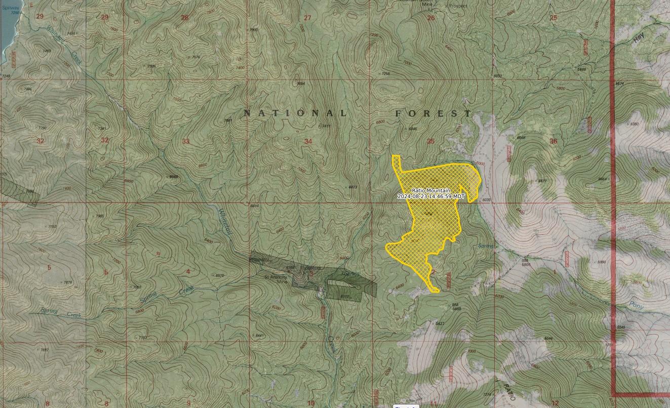
RATIO MOUNTAIN FIRE UPDATE
Incident Commander: Jonathan Stonelake, Scott Drake (T)
Location: 15 miles north/northwest of Whitehall, MT
Start Date: 8/18/2024
Cause: Lightning
Size: estimated at 587 acres
Resources on Site: 2 crews; 3 engines; helicopters available to assist
Total Personnel: 85
The Ratio Mountain Fire, located between Ratio Mountain and Whitetail Reservoir, is burning in an area that has recently experienced several large fires. Fire footprints (or previously burned areas) lie to the north (State Creek Fire of 2020), the south (McClusky Fire of 2019), and the west (Placer Fire of 2021) of the fire location.
The entire area, including the previous fire footprints and the area immediately surrounding the Ratio Mountain fire, contains a large concentration of standing dead trees (“snags”) that pose challenges to ensuring firefighter safety and in responding to potential medical emergencies, jeopardizing the well-being of firefighters and other responders.
Fire managers from the Forest, working in collaboration with local Jefferson County officials and cooperating agency representatives from the DNRC and BLM, have identified, mapped, and prioritized critical values at risk in the fire area. These inter-agency, values-based discussions are critical in fire management, informing the decision-making process.
CURRENT STATUS/PLANNED ACTIONS:
Strategic firing operations were successfully implemented on the eastern side of the fire, as firefighters used an Unmanned Aircraft System (“drone”) and hand ignitions to ignite and burn the fuels between the active fire edge and the constructed control lines from previous fire incidents along the Hay Canyon Road, working southerly along Pony Creek.
The crews have progressed approximately 70% of the way with completion of firing operations along this section of line. Continuation of this firing operation over the next few days will depend on fuel and weather conditions. This fire suppression tactic is an effective method of reducing the available fuels ahead of an active fire edge, while reducing the potential for negative impacts to the identified and prioritized values.
Smoke was visible in several areas, including the Whitetail Valley and the Interstate 90 corridor near Whitehall.
WEATHER AND FIRE BEHAVIOR:
The fire area received light precipitation yesterday afternoon, but the coverage was spotty and sporadic and not enough to impact fire behavior significantly. Fire behavior was limited to isolated torching, creeping, and backing. The forecast calls for widespread wetting rain and much cooler temperatures through the weekend.
CLOSURES AND RESTRICTIONS:
The Forest has issued an area closure around the fire area, north of Whitehall on the Butte Ranger District. An area closure often involves specific trail and road sections. The area closure information and maps can be found on the Forest website, under the Closures and Alerts tab. https://www.fs.usda.gov/alerts/bdnf/alerts-notices
This closure applies to the following National Forest System (NFS) lands, approximately 15 miles north of Whitehall.
All National Forest System lands within:
• T3N, R5W, SECTIONS 1, 2, 3
• T4N, R5W SECTION 35
Closures surrounding a fire area are necessary to protect the safety and welfare of the public and provide for safe firefighting efforts and access.
The Forest is in Stage 1 Fire Restrictions. Campfires are allowed only in a permanent metal fire grate/ring provided by the Forest Service in a designated, developed recreation site. Smoking is restricted to vehicles, in buildings, or in an area clear of flammable materials. Devices with an on/off switch that use LPG fuels are allowed in an area clear of flammable materials within 3 feet of the device.
North Ark Complex Daily Update 1030 AM 08 24 2024
Related Incident: North Art Complex
Publication Type: News
North Art Complex Fire Daily Update – 10:00 AM
Saturday, August 24, 2024
Size: 4,313 acres
Containment: 80%
Date Started: August 23, 2024
Cause: Lightning
Structures: At this time crews have not identified any damaged structures.
Evacuations: There have been no mandatory evacuations in place during this fire.
Closures: There are no road closures currently.
Yesterday: Crews were able to complete construction of containment lines yesterday before afternoon thunderstorms caused erratic winds, lightning and localized rain. Additional fires in the area pulled local resources away from the North Art Complex in the afternoon, but due to rough terrain, heavy equipment will likely not be a feasible option for response on the Bear Springs and Bode Peak Fires.
Today: This morning, crews are working to improve existing containment lines through mop up and firing operations. Crews will patrol the perimeter of the fire through the day. Due to yesterday’s widespread lightning with only localized rain, additional fires are expected to pop up this afternoon, and fire leadership has identified initial attack resources for needed response.
Weather and Fire Behavior: Temperatures are forecasted to be in the triple digits with relative humidity around 33%. A heat advisory is in effect from 1pm to 9pm for August 23, 2024. South winds 5 to 10 mph will shift southeast at 5 to 10 mph mid to late afternoon of August 23, 2024. Scattered showers and thunderstorms will be developing around 4 pm and will continue through 10 pm. Possibility of strong and erratic winds are possible near storms and additional lighting ignited wildfires are possible.
Fire Information
Kayla Driver Information Officer
Texas A&M Forest Service Texas A&M Forest Service
kayla.driver@tfs.tamu.edu information@tfs.tamu.edu
325-304-4914 979-255-0591
Inciweb: https://inciweb.wildfire.gov/incident-information/txtxs-north-art-complex
Facebook: https://www.facebook.com/AllHazardsTFS
Twitter: https://twitter.com/AllHazardsTFS
Flat Fire Update 08 24 2024
Related Incident:
Publication Type: News
August 24, 2024
Email: 2024.flat@firenet.gov
Incident Information Phone Line: 208-923-1265 - daily 8 a.m. to 8 p.m.
Flat Fire Facebook: https://www.facebook.com/IdahoDepartmentofLands
InciWeb: https://inciweb.wildfire.gov/incident-information/idids-2024-flat
Smoke Report: https://www.airnow.gov
Flat Fire Facts
Location: Approximately one mile northeast of Pioneerville in Boise County, Idaho
Reported: August 5, 2024; Cause: Lightning/Natural
Acres: 3,732; Containment: 53%
Fuels: Timber with grass and understory
Personnel: 413 (9 hand crews, 10 engines, 6 water tenders, 1 dozer, 3 masticators and 3 helicopters)
Highlights: In spite of the hot, dry, and gusty winds over the past couple of days, the Flat Fire remains well within its original footprint. The weather over the past two days has tested the Flat fire lines with little affect. There has been little fire behavior and relatively little active burning and open flames.
All and all, it was another good day for firefighters that have been working hard to contain the Flat Fire. Firefighters over the next few days will continue to patrol the fire area looking for hot spots to mop-up.
They will be backhauling, or removing excess fire equipment off the fire lines where they are no longer needed. This includes such fire items as hoses, pumps, collapsible water tanks, nozzles, plumbing hardware, fuel containers, etc.
Firefighters are also working on fire line and suppression repair efforts in those areas of the fire line that have good containment and are no longer at risk of escape. They are returning the disturbed areas, fire lines, staging areas, helipads etc., to as natural a state as is practicable. This is to minimize any future damages due to erosion.
The indirect dozer line on the east flank of the fire that has burned into the 2016 Pioneer Fire burn scar was completed today. Work remains on the southernmost corner of the fire where firefighters will connect the direct hand line with the indirect dozer line. This will complete a containment line around the fire that will be monitored and patrol for the foreseeable future. Firefighters will remain on scene continuing to look for hot spots and mop up areas where any heat is found.
Fire Behavior and Weather: Over the next couple of days, a Pacific storm system will move across the Pacific Northwest. Moisture and relative humidity (RH) will increase, along with isolated to scattered rain showers. Chances of wetting rains are low, with showers being light in nature. Cooler temperatures and RH above 30% expected on Sunday. Dry and warm weather conditions return next week.
Road and Trail Closures and Restrictions: The Boise National Forest has implemented an Area Closure for the Flat Fire. See link for additional information: https://www.fs.usda.gov/alerts/boise/alerts-notices. The Summit Flat Road (#380) between Pioneerville and Coulter Summit and FS Road 379 (Elk Creek Road) is closed for public and firefighter safety.
Fires Burning in the Vicinity: There are other fires burning north of the Flat Fire. See link for additional information: https://inciweb.wildfire.gov/incident-information/idbof-middle-fork-complex-fire-bulldog-nellie-anderson.
###