
Actualizacin diaria del incendio Pioneer 22 de agosto de 2024 08 22 2024
Related Incident:
Publication Type: News
Actualización diaria del incendio Pioneer
22 de agosto de 2024
Tamaño: 38,730 acres
Fecha de inicio: 8 de junio de 2024
Ubicación: 31 millas al NO de Chelan, WA
Contención: 23%
Personal: 519
Causa: A ser determinada
Recursos asignados: 3 equipos de obreros, 6 helicópteros, 16 camiones de bomberos, 22 tanques de agua, 9 maquinarias pesadas
SITUACIÓN ACTUAL: El personal de extinción realizó un vuelo ayer sobre la zona del incendio y observó un calor mínimo en el fuego. El fuego ha crecido muy poco o nada en los últimos días. Ayer, los bomberos patrullaron la línea de mano de Little Boulder y monitorearon la línea de verificación de retardante en búsqueda de calor. Observaron pequeños focos de calor en el interior del incendio y el fuego sigue dentro de la línea de mano y la línea de control. Al sur del incendio, los recursos están terminando el trabajo que queda de eliminar los escombros de vegetación de los preparativos de la línea de contingencia y reparar los caminos dañados por el tráfico del fuego.
El Equipo 3 de gestión de incidentes del Noroeste llevó a caba una sesión informativa virtual comunitaria el 21 de agosto. Se dió una visión general de la actividad actual del fuego y del trabajo contra incendios. Una grabación de la sesión informativa virtual comunitaria del 21 de agosto se puede ver en la página de Facebook de información de los incendios Pioneer e Easy en facebook.com/profile.php?id=61560760893080.
ACTIVIDADES DE HOY: Los bomberos patrullarán y fortalecerán la línea de mano alrededor de Little Boulder Creek. Observarán la línea de control en Rainbow Ridge en búsqueda de cualquier calor. Las cuadrillas continuarán astillando y transportando los escombros de vegetación en Stehekin. Las cuadrillas monitorearán la orilla del lago por bote, según sea necesario. Los recursos continuarán el trabajo de trituración y el transporte de escombros cerca de Manson. Los bomberos están listos para el ataque inicial de nuevos fuegos si es necesario.
CLIMA: Las condiciones secas de hoy cambiarán a más húmedas esta noche y mañana. Hoy estará mayormente nublado con una posibilidad de lluvias después de las 10 a.m. Los vientos soplarán del sureste en las laderas y crestas superiores, luego cambiarán a lago abajo por la tarde. Las temperaturas máximas estarán entre los 70 y los 70 grados.
EVACUACIONES: Están vigentes las órdenes de evacuación para el incendio Pioneer y el área de Stehekin permanece cerrada a los visitantes. Para ver más información, visite: https://www.co.chelan.wa.us/emergency-management/pages/active-emergencies.
Closures: Cierres actuales para el Parque Nacional North Cascades: https://www.nps.gov/noca/index.htm. El Bosque Nacional Okanogan-Wenatchee ha emitido una orden de cierre sobre gran parte del área afectada por el incendio: Okanogan-Wenatchee National Forest - Alerts & Closures (usda.gov). Las fogatas están prohibidas. El sendero Pacific Crest Trail está cerrado en diferentes áreas de Washington debido a varios incendios. Para más información, visite closures.pcta.org/. Hay una restricción temporal de vuelo (TFR, en inglés) sobre el área del incendio: https://tfr.faa.gov/save_pages/detail_4_6779.html. La actividad de drones no autorizados está prohibida por la TFR.
InciWeb: https://inciweb.wildfire.gov/incident-information/wases-pioneer
Facebook: https://www.facebook.com/profile.php?id=61560760893080
Línea de información sobre el incendio: 541-861-5808, de 8 AM a 8 PM
Correo electrónico: 2024.pioneer@firenet.gov
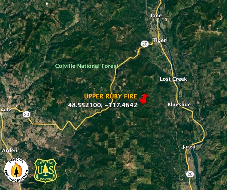
Upper Ruby Fire Daily Update 08 22 2024
Related Incident:
Publication Type: News
August 22, 2024 Upper Ruby Fire Daily Update
Fire Perimeter: approx. 220 acres*
Initial Start: 08/20/24
Location: About 10 mi. southwest of Ione, WA
Hazards: Timber snags, bees, soft shoulders and narrow roads
Values at Risk: Private residences, ongoing timber sales
Cause: Undetermined
Containment: 0%
Personnel: approximately 185
Structures destroyed: 0
Evacuations: None
Road Closures: Ruby Creek Road (4 miles in from Hwy 20), Tacoma Creek Rd (about 11 miles west of Hwy 20), and Tacoma Divide Road (about 4 miles south of Hwy 20)
Evacuations: The Pend Oreille County Sherriff has issued no evacuation orders for the Upper Ruby Creek fire.
Ione, WA –
PUBLIC AND FIRE FIGHTER SAFETY IS THE NUMBER ONE PRIORITY.
The Upper Ruby fire was detected on August 20th in the Ruby Creek drainage in central Pend Oreille County, WA, about 10 miles southwest of Ione, WA. It is burning in fuels remaining on the ground following logging activities and in heavily forested areas.
Initial attack efforts the past two days included engines, heavy equipment, hand crews, and aerial resources. Ten to twenty loads of fire retardant and extensive water drops aided on-the-ground firefighting resources in limiting southern and western movement of the fire and keeping fire from the private property on the south end of the fire.
Heavy equipment will be used extensively to clear vegetation and install control lines, with hand crews scouting and building line in less accessible areas. Air support will be used to keep the fire cooled in areas where ground resources are working and to help them extinguish spot fires and any new starts in the area. Standing dead trees (snags), and bees pose hazards to firefighters.
Weather today will be partly cloudy, with light predicted winds from the north. Up to of ½ rain is predicted over the fire area on Sunday with much cooler temperatures.
Northeast Washington Type 3 Incident Management Team 3 assumed command of the fire at 6 p.m. on Wednesday, August 21, 2024.
* Note: more accurate fire perimeter is expected after mapping today.

North Willamette Complex Ore and Pyramid Fires Daily Update 08 22 2024
Related Incident: North Willamette Complex
Publication Type: News
Willamette Complex North
Daily Update
2024.WillametteComplex.North@firenet.gov
Information line: 541-208-1262, 8 am to 8 pm
Facebook: facebook.com/OreFireInformation2024
Inciweb: inciweb.wildfire.gov
August 22, 2024
SPECIAL NOTE: State Route OR-126 has reopened today from mile marker 13 East.
CURRENT SITUATION: Conditions will be slightly cooler with higher humidity today, again leading to reduced fire activity and spread probability, with increased chances of a wetting rain through today and into Friday night. A warming and drying trend is expected later this coming weekend into next week.
Ore Fire: 7 miles Northeast Blue River, 3,140 Acres, 16% Contained, 668 Total Personnel, Human Caused. Day and night shift resources continue to secure containment lines. Current weather and fuel conditions do not support additional firing operations which are required to continue to increase the fire perimeter containment. Crews on the northeastern fire area will continue to construct and improve containment lines, while crews on the east and west fire areas continue to strengthen existing and create new contingency lines. The southwestern and southeastern areas remain solid barriers to fire spread.
Pyramid Fire: East of Middle Santiam Wilderness, 1,312 Acres, 88% Contained, 315 Total Personnel, Lightning Caused. On the west and northwest area of the fire, work continues to build fire line between the fire area and the wilderness area. The roadside wood and brush chipping, removal of fire fuels and wood debris is ongoing, and crews continue to secure containment lines and clean up outlying contingency lines. A contingency line is a secondary or alternate strategic fire line, which is created as a back up to the primary fire line, based on current needs and conditions. Firefighters are also working to strengthen existing fire breaks along roads by removing brush and smaller trees to widen a fuel break. Cleared vegetation may be chipped on site or hauled away for utilization.
CLOSURES & FIRE RESTRICTIONS UPDATE: Please refer to the Linn County Fire Map for current status. (Please see below).
Area, road, trail, and recreation site closures are in effect on the Willamette National Forest. Specific information is posted at https://www.fs.usda.gov/alerts/willamette/alerts-notices/?aid=61574. Please see Pyramid Fire Area Closure Forest Order and the Ore Fire Area Closure Forest Order.
Due to long term hot and dry conditions, all campfires, charcoal fires, pellet fires, or any other open fires are prohibited, including in developed campgrounds and wilderness areas. Pressurized liquid or gas stoves, lanterns, and heaters that can be switched on and off are allowed. Please see Forest Order 06-18-00-24-27 for additional information.
ROADS: When traveling in the area, please be mindful of firefighters and their vehicles working near roads. Please visit the Oregon Department of Transportation website for current road conditions.
BAER INFORMATION BRIEF Preparing for Rain After California Wildfires 08 22 2024
Related Incident: Park Post-Fire BAER
Publication Type: News
Post-Fire BAER Assessment
Burned Area Emergency Response (BAER)
Information Brief
Preparing for Rain After California Wildfires
POST-FIRE WATERSHED CONDITIONS—KEY MESSAGES
While many wildfires cause minimal damage to the land and pose few threats to the land or people downstream, some fires cause damage that requires special efforts to prevent problems afterwards.
Summer monsoon thunderstorms and winter rain events in California mountain areas can result in high water runoff and flooding.
Wildfire increases the potential for flooding, post-fire soil erosion and debris flows that could impact campgrounds, fishing areas, homes, structures, roads, and other infrastructure within, adjacent to, and downstream from the burned areas.
Post-fire, watershed conditions will naturally receive and transport water and sediment differently than during pre-fire conditions.
The public and communities adjacent to and downstream from the wildfire areas should expect increased flooding and debris transport during less than average rain events.
SAFETY CONCERNS CONTINUE AFTER THE FIRE IS OUT
The potential for increased water runoff and debris flows are not just a one-year concern.
We recognize the threat potential of flash floods and debris flows may exist for the next several years, depending on the intensity of these storms.
For life and safety concerns, burned area public land closures are sometimes implemented prior to forecast rain events until the burned area fully recovers.
Residents and visitors should remain alert to weather events and plan ahead when travelling along roads within and downstream from the burned areas.
ASSESSING BURNED WATERSHEDS RESPONSE
Forest Service Burned Area Emergency Response (BAER) teams work with each of the national forests, to assess the condition of the watersheds on National Forest System (NFS) lands burned by wildfires.
BAER assessment teams identify potential emergency threats to BAER critical values that may be considered at-risk on federal lands such as:
- Human life and safety.
- NFS property, such as buildings, water systems and infrastructure, utility systems, road and trail prisms.
- Critical natural resources such as water, soil productivity and hydrologic function, areas where invasive species or noxious weeds may impact native or naturalized communities and may include critical habitat or suitable occupied habitat for federally listed threatened or endangered species.
- Critical cultural and heritage resources such as pre-historic and historic properties and sites.
BAER assessment teams recommend emergency stabilization response actions that are implemented on federal land to reduce potential post-fire threats.
PREPARING FOR POTENTIAL FLOODING AND DEBRIS-FLOWS FROM WILDFIRE BURNED AREAS
For values and resources potentially impacted off federal lands, one of the most effective BAER strategies is interagency coordination with local cooperators who assist affected businesses, homes, and landowners with preparing for rain events.
While multi-agency efforts are being taken to reduce the risks to life and safety adjacent to and downstream from the burned areas, nearby residents should develop individual plans to protect themselves and their property.
The USDA Forest Service and the USDA Natural Resources Conservation Service (NRCS) work together and coordinate with other federal, state and local agencies, and counties that assist private landowners in preparing for increased water run-off and potential flooding impacts.
NRCS and local sponsors prepare damage survey reports for eligible sites on private lands adjacent to and downstream from affected areas. NRCS uses these reports, along with the Forest Service BAER team’s assessment report, to develop emergency measures to reduce the impacts from potential increased water and debris flows, and assist local sponsors to implement recommended emergency measures through its Emergency Watershed Protection (EWP) Program: (NRCS_EWPP_Fact Sheet-2021.pdf (usda.gov)).
All EWP Program–Recovery projects begin with a local sponsor or legal subdivision of state or tribal government. Eligible sponsors include cities, counties, towns, conservation districts, or any federally recognized Native American tribe or tribal organization. Interested public and private landowners can apply for EWP Program–Recovery assistance through one of those sponsors. For more information on NRCS Disaster Assistance Programs: Emergency Watershed Protection | Natural Resources Conservation Service (usda.gov).
The following links provide information and references for state and local county offices of emergency management promote preparedness through its emergency services programs to assist the public to prepare for, respond appropriately to, and quickly recover from natural emergencies that may impact county residents and visitors:
Flood After Fire--California Toolkit
After the Fire—California Resources
California Current Road Conditions
Cal-Fire—Fire and Resource Assistance
California Governor's Office of Emergency Services
California Watershed Emergency Response Team (WERT)
Homes or businesses that could be impacted by flooding from federal land that resulted from wildfires may be eligible for flood insurance coverage from the National Flood Insurance Program (NFIP). Information about NFIP is available through FEMA at www.fema.gov/national-flood-insurance-program, or FEMA Wildfire Increases Flood Risk. Other flood preparedness information is available at www.ready.gov/floods and www.floodsmart.gov/.
LINKS TO ADDITIONAL RESOURCES AND WEBSITES
NRCS Wildfire Disaster Recovery
NRCS Post-Fire Disaster Assistance
FEMA Wildfire Increases Flood Risk
FEMA Flood After Fire—Fact Sheet
Recovering from Wildfire-Damage Assessments
Flood Safety Emergency Preparedness
Be Ready & Prepare for Emergencies
NWS Weather Information—Los Angeles CA
NWS Weather Information—Sacramento CA
NWS Post-Wildfire Flash Flood-Debris Flow Guide
NWS Burn Scar Flash Flood & Debris Flow Risks
Red Cross Emergency Preparedness
BAER SAFETY MESSAGE: Everyone near and downstream from the burned areas should remain alert and stay updated on weather conditions that may result in heavy rains and increased water runoff. Flash flooding may occur quickly during heavy rain events--be prepared to act. Current weather and emergency notifications can be found at National Weather Service website: www.weather.gov/sto/.
Homestead Complex 2024 Thursday 08 22 2024
Related Incident:
Publication Type: News
Homestead Complex Fire Update for Thursday, August 22, 2024
No Man, Salmon 33, Horse Heaven Creek, Bullpup, Fuller Lake, Reynold’s Butte, Lost Bucket
Start date: July 19, 2024 | Location: Northeast of Glide, Oregon | Total Personnel: 1005
Total Homestead Complex Fire size: 5,891 acres | Cause: Lightning | Containment: 35%
Summary
Fire behavior reduced significantly yesterday, advancing as little as 10 feet in 24 hours in areas. Fire continues to creep and smolder, lingering in drainages and heavy surface fuels.
No Man (2,080 acres) and Salmon 33 (261 ac.): Back hauling supplies has started on the Salmon 33 Fire, along with continued line improvement, adding depth to containment. On No Man, crews will continue securing direct control lines and implement tactical firing operations, weather permitting.
Horse Heaven Creek Fire (2,292 ac.): Crews will continue chipping along primary and secondary control lines with heavy equipment and will be removing fire-damaged logs from the area. Fire managers continue to evaluate for strategic burning operations along the southwest perimeter.
Bullpup Fire (476 ac.) and Fuller Lake Fire (414 ac.): Crews will put in direct handline on the northern perimeter of the fire in steep, rough terrain, adding to containment in that area.
Reynolds Butte Fire (334 ac): Overall containment was strengthened, and resources will continue to improve lines, patrol, and mop up interior.
Lost Bucket Fire (34 ac.): 100% contained on July 29, 2024.
Weather: Today, weather will be unseasonably cool with expected showers in the evening after 5pm. Temperatures will be in the low 60s during the operational period, with relative humidity recovery reaching 90-100% at night. Precipitation will come in two waves starting Thursday evening with light rain, and scattered, patchy showers continuing Friday. Expected rainfall will be ¼ to ½ inch over the entire complex area.
Closures and Fire Restrictions
The Bureau of Land Management (BLM), Roseburg District, has issued a closure order for portions of BLM land which border the Umpqua National Forest Emergency Fire Closure north of Steamboat. The closure order can be viewed here: https://www.blm.gov/sites/default/files/docs/2024-07/orwa-fpo-rbg-072624.pdf.
The Umpqua National Forest has Emergency Fire Closures in place impacting every district of the forest. https://www.fs.usda.gov/alerts/umpqua/alerts-notices.
There is a Temporary Flight Restriction (TFR) over the Homestead Complex Fire. Please remember, if you fly we can’t! If a drone or other aircraft enters the air space, all firefighting aviation equipment will be grounded.
Fire Information Line: 541-208-7100 (Staffed 8 a.m. to 8 p.m.)
BAER INFORMATION BRIEF Understanding Soil Burn Severity 08 22 2024
Related Incident: Park Post-Fire BAER
Publication Type: News
Post-Fire BAER Assessment
Burned Area Emergency Response (BAER)
Information Brief
Understanding Soil Burn Severity
We tend to think of wildfire burn severity in terms of the visual impacts to above-ground vegetation, but the post-fire landscape response (erosion, flooding, and mass movement) is generally more strongly correlated to soil burn severity. When characterizing soil burn severity, looking at the vegetation is a good starting place to understand the conditions on the ground.
Armed with that information, the BAER team’s watershed specialists (soil scientists, hydrologists, and geologists) ground-truth different vegetation burn intensities to tease out patterns of how fire affected and changed the properties of the soil. Pre-fire ground cover, forest type, fire behavior, slope, aspect, and other factors all influence soil burn severity. After field observations are collected, specialists adjust the vegetation severity map to create the soil burn severity (SBS) map. The SBS is broken into four different classes: unburned (green), low severity (blue), moderate severity (yellow), and high severity (red).
So, what do these different classifications mean?
LOW severity areas generally have intact and recognizable litter layers (organic material on the forest floor, such as pine needles and twigs). These litter layers may be charred but are not consumed. Underlying topsoil is intact, and near-surface fine roots are unburned. These soils have enough cover to protect them from erosion during rain events because their natural porosity and structure allow rain to soak into the soil instead of running off, while fine roots provide stability. In low severity areas, burns may have been patchy islands of green vegetation and intact canopies may be present.
MODERATE severity areas generally have more—up to 80% of their pre-fire surface litter layers consumed by fire. Black or gray ash may be present on the soil surface. Fine roots near the surface may be scorched and killed. Topsoil layers are generally intact with minimal impacts to the soil’s ability to absorb moisture. Soils with moderate severity are more susceptible to erosion in post-fire rain events because they have lost protective surface cover and may have less surface stability because of root mortality.
HIGH severity areas generally have had all their pre-fire surface litter layers consumed by fire. White or gray ash may be present on the soil surface. Fine roots are often fully burned/consumed within several inches of the soil surface, and even large tree roots may have burned deep into the soil. Soil may be powdery or grainy and loose, unable to bind together and retain water. These soils are very susceptible to erosion and often have high surface run-off during rainstorms.
So, what does the BAER team do with the SBS map?
The BAER team uses the SBS map to make predictions about how the landscape will respond after fires. Soil scientists consider where soil productivity will be degraded due to erosion losses and where sediment may move into stream channels. Hydrologists use the SBS to predict watershed response—surface runoff from high SBS areas in rainstorms can produce more “flashy” behavior in stream systems. Geologists use the SBS to inform predictions for debris flow or other mass movement potential based on reduced soil stability in steep drainages.
BAER teams focus on emergency responses to stabilize burned areas that may impact Forest Service critical infrastructure or other values located within or immediately downstream of high soil burn severity areas.
BAER SAFETY MESSAGE: Everyone near and downstream from the burned areas should remain alert and stay updated on weather conditions that may result in heavy rains and increased water runoff. Flash flooding may occur quickly during heavy rain events--be prepared to act. Current weather and emergency notifications can be found at National Weather Service website: www.weather.gov/sto/.
BAER INFORMATION BRIEF Fire Severity and Fire Intensity Effects 08 22 2024
Related Incident: Park Post-Fire BAER
Publication Type: News
BAER INFORMATION BRIEF: Fire Severity and Fire Intensity Effects
There are several types of fire severity and intensity maps that you may see. Although they look different for the same fire, they may also all be accurate. This is because fire severity or intensity are different measures of the fire effects on a specific resource such as soils, tree canopies, vegetation or wildlife habitat. Burned Area Emergency Response (BAER) maps are primarily measures of fire effects on soils. The following is a description of BAER fire severity mapping for soil burn severity levels.
SOIL BURN SEVERITY RATING OVERVIEW:
High Soil Burn Severity Rating: (severe damage to the soils): deeply burned soils with high water repellent soils (tend to be places where the fire burned the forest canopy, ground cover, roots, and organic matter in the topsoil).
Moderate Soil Burn Severity Rating: burned soil with moderate water repellent soils (much of the root, soil structure, and organic matter stayed intact and could help buffer the rainstorms that might cause erosion) can produce increased water run-off and soil erosion depending on the timing, magnitude, and duration of future precipitation. The remaining vegetation could quickly re-sprout and provide some cover from dead needles and leaf fall to reduce erosion.
Low Soil Burn Severity Rating: light soil burning includes land that may have burned in recent occurrences with brush or young timber growing on it.
KEY MESSAGES:
• Fire severity and intensity are separate measures of the effects of fire on a defined resource.
• All fire severity or intensity maps view landscapes from different perspectives, so various maps of the same fire can look very different, and all be accurate.
• The BAER soil burn severity maps specifically focus on severity to soils and watersheds.
• There are also several other types of fire severity or intensity maps – many of which focus on different aspects of vegetation such as, Burned Area Reflectance Classification (BARC) and Vegetation severity or intensity maps are both vegetation maps but will also look different for the same location and time.
• Vegetation severity and intensity maps also come from a number of different perspectives, and can be short-term or long-term views.
• During post-fire assessments, the BAER team uses the term “soil burn severity” to differentiate post-fire soil properties from fire effects on vegetation (such as tree mortality), and/or general fire effects on the long-term ecosystem health.
• When a fire slowly consumes fuel (long residence time), the fire (soil burn) severity is usually high.
• Ground cover refers to the organic material on the top of the soil layer, and includes vegetative litter, duff, and woody debris.
• When organic material within the ground cover and within the soil structure burns at high intensity, some of the water repellent components vaporize, and condense on the soil at the surface or deeper depending on the severity of the fire.
• The correlation between fire intensity and soil burn severity is not always direct because the amount of heat generated and time duration both plays a critical role in the fire effects to soil.
• Because of the variability of fuel consumption, soil heating typically is non-uniform across landscapes.
• Wildfire does not always impact soils and vegetation in the same way.
• A hot, fast moving fire can consume much of the vegetation and move through so quickly that the soils remain largely intact.
• Soil scientists evaluate preliminary burn maps from satellite imagery to determine the effects and create a soil burn severity map.
• Hydrologists use that information to model storm runoff over the burned area to estimate potential flood impacts to lives and property.
• Foresters use the same satellite images to create a different map that displays post-fire impacts to the trees.
• A hot, fast-moving fire (wind-driven) can consume the majority of vegetation (especially when dry with low fuel moistures) in a burned area and can be classified as a high intensity fire area by fire ecologists/fire behavior analysts.
• When the duration (also described as residency time) of the fire is short (fast moving, wind-driven), it can result in a low-to-moderate soil burn severity rating by BAER soils scientists because the soil did not get a lot of lingering heat on the ground.
BAER SAFETY MESSAGE: Everyone near and downstream from the burned areas should remain alert and stay updated on weather conditions that may result in heavy rains and increased water runoff. Flash flooding may occur quickly during heavy rain events--be prepared to act. Current weather and emergency notifications can be found at the National Weather Service website: www.weather.gov/sto/.
Stayman Fire Update 08 22 2024
Related Incident:
Publication Type: News
Stayman Fire Update
August 22, 2024
Quick Facts
Size: 3,118 acres* Start Date: August 20, 2024 Location: 1.5 miles SE of Chelan
Containment: 0% Personnel: 167 Cause: Under investigation
Resources Assigned: 5 crews, 27 engines, 1 helicopter, 3 water tenders
*change in acreage due to more accurate mapping
CURRENT SITUATION: Firefighters flew over the fire area yesterday and observed very little residual smoke. Fire activity was greatly reduced from the previous day and firefighters have been successful stopping further fire spread. Ground resources patrolled the fire perimeter and worked to secure the east and west flanks of the fire, mopping up to a depth of 30 feet and extinguishing any hot spots. At the head of the fire near the communication site, firefighters worked to reinforce and secure the constructed handline.
Northwest Incident Management Team 3 held a virtual community briefing on August 21. They provided an overview of current fire activity and fire operations on the Stayman Fire. A recording of the August 21 virtual community briefing can be viewed on the Pioneer and Easy Fires Information Facebook Page at facebook.com/profile.php?id=61560760893080.
TODAY’S ACTIVITIES: Firefighters will continue working to secure the fire’s edge today. They will continue patrolling and mopping up along the east and west flanks while continuing to secure the northeastern edge at the head of the fire. Helicopter water drops maybe used to support operations, if needed. Boaters are asked to give space to aviation resources that may need to pull water from the lake to support firefighting operations.
WEATHER: Temperatures will be in the high-70s and perhaps into the low 80s today. There is a chance of spotty showers in the early morning, with increasing chance of showers through Saturday. Winds will be light, and terrain driven through the morning hours, increasing in the afternoon with a more northeasterly component.
EVACUATIONS: Evacuation orders are in place for the Stayman Fire. For current evacuation information, please contact Chelan County Emergency Management (facebook.com/CCSOEM) or view the Chelan County Emergency Incidents Map: Chelan Co Emergency Incidents App (arcgis.com).
InciWeb: https://inciweb.wildfire.gov/incident-information/wases-pioneer
Facebook: https://www.facebook.com/profile.php?id=61560760893080
Fire Information Line: 541-861-5808, 8 a.m. to 8 p.m.
Email: 2024.pioneer@firenet.gov
Middle Fork Complex Wapiti Bull Trout Fire Update Thursday 08 22 2024
Related Incident: Bulltrout Fire
Publication Type: News
Attached is today's map (find more detailed maps on Inciweb), update (also see full text below), and smoke report for the Middle Fork Complex, Wapiti, and Bull Trout Fires. Closure orders and maps for the fire areas can be found on the Boise National Forest’s Alerts and Notices webpage as well as on Inciweb.
Incident Commander: Rick Connell, Northern Rockies Team 5
Middle Fork Complex Location: 9 miles east of Garden Valley, ID
Bull Trout Location: 15 miles WNW of Stanley, ID Wapiti Location: 2 miles southwest of Grandjean, ID
Start Dates: 07/24/24 – 08/06/2024
Cause: Lightning
Size: Infrared mapping services were unable to fly over the fire area last night so acres will be updated when possible.
Bull Trout: 271 acres Wapiti: 17,520
Middle Fork Complex: 31,087 Bulldog: 5,801 Nellie: 25,286
Containment: Middle Fork Complex: 5% Wapiti: 10% Bull Trout: 92%
Resources on site:
Middle Fork Complex: 1 hot shot crew; 9 type 2 hand crews; 14 engines; 2 water tenders; 1 bulldozer, 1 feller-buncher
Wapiti: 5 hot shot crews; 2 type 2 hand crews; 19 engines; 2 water tenders; 1 skidgen, 1 bulldozer
Bull Trout: none
Total Personnel: Middle Fork Complex: 468 Wapiti: 258 Bull Trout: 0
KEY MESSAGE:
On the Nellie Fire, the Boise County Sheriff’s Office has issued a stage 1 (“Ready”) evacuation notice for the area from Danskin station west to Grimes Pass along highway 17, for both sides of the highway and both sides of the South Fork of the Payette River.
Wapiti Fire has been moving North toward the Stanley Lake area. For residents in the Stanley Lake and HWY 75 area, please utilize your local Custer County notification system and follow instructions of emergency responders. Currently zone 1 is in “set” and zone 2 is in “ready” please visit Custer County Sheriff’s Facebook page for a map of the zones. Custer county ready set go, Red Alert system – Custer County Text CUSTER to 99411 to enroll in CodeRED (click here) or enroll online at https: /public.coderedweb.com/CNE/BF28E45537FF to Receive updates through Integrated Public Alert and Warning System (IPAWS) set your phones to receive Alerts by going into settings and then Notifications and turning on your Emergency Alerts. Custer County Sheriff's Facebook Page Link (click on for updates and Important Information)
The National Weather Service has issued a red flag warning today for hot and very dry condition along with gusty south winds. Conditions will be similar to last Saturday and the inversions will lift around 1-2pm creating active fire behavior and potential for large fire growth.
The Middle Fork Complex and Wapiti Fire will be transitioning separate incident management teams in the next couple days. Great Basin Team 3 will assume command of the Middlefork Complex (Bulldog and Nellie Fires) Friday morning at 6 am and Rocky Mountain Team 1 will assume command of the Wapiti Fire on Sunday at 6 am.
CURRENT STATUS/PLANNED ACTIONS:
Middle Fork Complex: The Middle Fork Complex is comprised of the Bulldog and Nellie fires.
The Bulldog Fire has seen minimal growth and crews continue to work along FS road 698 holding the fire along the east edge of the fire. The Silver creek area has been assessed and strategies are in place for firefighters to protect infrastructure to the north of the fire. On the south end of the fire, containment lines are holding, and firefighters continue to search for and extinguish hot spots. Fire is expected to spread more rapidly through the Rattlesnake fire area along ridgelines today. The public is reminded that the Middlefork Road (FS Road 698) is closed at the Forest Service boundary just north of Lightning Creek and the Scriver Creek Road (FS Road 693) is also closed at the Forest Service Boundary for firefighter and public safety as crews continue to work to protect private property and structures in the vicinity of Crouch.
On the Nellie Fire, aircraft, crews and heavy equipment were utilized yesterday to limit the spread to the south along the fuel change from timber to grass and shrubs. Overnight, embers ignited a spot to the south of the fire, along Highway 17, however the highway is open at this time. Firefighters worked late into the night in the Danskin area and will be working 24 hours a day to protect values and infrastructure. Crews, heavy equipment and aircraft will be working along the highway today and congestion is expected, please drive safely. On the north side of Nellie firefighters installed pumps, hoses, and sprinklers near infrastructure. Additionally, fuels reduction was completed to improve defensible space around structures in and around the wildland urban interface. The fire continues to grow to the north between the historic Pioneer Fire area and the Rattlesnake fire area. The public is reminded that Forest Service Road #555 is closed at the intersection of Highway 17 all the way to the Forest Service Road #579 intersection.
Wapiti Fire:
The Wapiti fire has been actively growing due to weather conditions. It continues to move to the north along Elk Creek drainage, west across Highway 21 at the Emile Grandjean Overlook (mile marker 95), and to the east. North of the fire, terrain driven winds and heavy fuels consisting of timber and dead standing timber will create active fire behavior. Crews and heavy equipment are working on fuels reduction and defensible space around the structures in and around the wildland urban interface. West of the fire, in the Hanging Valley area, firefighters have completed fuels reduction and strategically placed pumps, hoses and sprinkler systems. Due to fire activity overnight, the Grandjean road and Highway 21 have been impacted by rolling debris that obstruct access to some areas. Fire managers are working with Idaho Department of Transportation to remove the debris and provide access for firefighters. Highway 21 remains closed from MP92 to MP107.
Bull Trout Fire: The Bull Trout fire is still 92% contained, with very little change in the past few days. Today an infrared flight is planned to check for pockets of heat.
WEATHER AND FIRE BEHAVIOR:
Red Flag warning in effect for critical fire weather today and tomorrow, ahead of a cold front moving into the area. Elements of extreme fire behavior are expected today, and south winds with hot dry conditions will cause large fire growth over the fire areas. Southerly winds will increase by early afternoon along upper ridge lines and along wind aligned drainages. Winds will remain elevated well into the evening with marginal relative humidity recovery tonight. Sheltered areas can expect variable and erratic winds at times as these southerly winds battle the terrain driven flow. Temperatures will be 8-10 degrees warmer than yesterday. Under previously similar conditions, fire spread rapidly to the north with spotting along wind aligned drainages. Spotting potential is up to 2 miles. Group torching is expected with terrain influenced fire spread. Thermal belts of warm air will be present overnight tonight which allows fires to actively burn until late into the evening.
CLOSURES, RESTRICTIONS, AND EVACUATIONS:
Middle Fork Complex: The Boise County Sheriff's Office continues to maintain the Level 2 evacuation notice for residents on and near the Middlefork Road between Stump Ranch Road up to Tie Creek Campground. The Boise National Forest issued an area closure for the fire (Closure #0402-06-59) effective August 12, 2024. The purpose of this order is to protect public safety during the fires.
Wapiti Fire: The evacuation order for Summer Homes and the Sawtooth Lodge remain in effect for the Wapiti Fire, as does the area closure issued by the Sawtooth and Boise National Forests (Closure #0402-05-94) effective August 12, 2024. This Order is for public and firefighter safety during fire suppression efforts of the Wapiti Fire.
Bull Trout Fire: The Bull Trout Fire Area Closure (Closure #0402-05-93) remains in effect for the roads and trails within the perimeter of the fire. The Boise National Forest issued this order on August,12, 2024. It will be rescinded as soon as it is safe to do so.
The Boise County Sheriff’s Office has issued a stage 1 (“Ready”) evacuation notice for the area from Danskin station west to Grimes Pass along highway 17, for both sides of the highway and both sides of the south fork of the Payette River. The Boise County Sheriff’s Office has issued a mandatory evacuation order for the Danskin area north of Highway 17 and the community of Hanging Valley due to the Highway 21 closure.
Evacuation information will be posted on the Boise County Sheriff’s Office Facebook page. For closure information, please visit Boise National Forest’s website – Alerts & Closures. Smoke will be visible and could impact roadways today, please follow the instructions of emergency responders and drive safely.
Closure information and maps are posted on the Forest’s website and the fire’s Inciweb page as they are in place. https://tinyurl.com/2u8v3pf7
The Boise National Forest, Idaho Department of Lands, and Bureau of Land Management are in Stage 1 fire restrictions on state, endowment, private and federal lands within the West Central Mountains Fire Restrictions Zone. For more information on the restrictions and a map visit:
https://www.idl.idaho.gov/fire-management/fire-restrictions-finder/
Pioneer Fire Update 08 22 2024
Related Incident:
Publication Type: News
Pioneer Fire Update
August 22, 2024
Quick Facts
Size: 38,730 acres
Start Date: June 8, 2024
Location: 31 miles NW of Chelan, WA
Containment: 23%
Personnel: 519
Cause: Under investigation
Resources Assigned: 3 crews, 6 helicopters, 16 engines, 22 water tenders, 9 heavy equipment
CURRENT SITUATION: Firefighting personnel flew over the fire area yesterday and found minimal heat on the fire. There has been very little to no growth of the fire in recent days. Yesterday firefighters patrolled the Little Boulder handline and monitored the retardant check line for any heat. Firefighters observed small pockets of heat in the interior of the fire and the fire continues to hold within the handline and check line. South of the fire, resources are completing remaining work to remove vegetation debris from contingency line preparations and repair roads damaged from fire traffic.
Northwest Incident Management Team 3 held a virtual community briefing on August 21. They provided an overview of current fire activity and fire operations. A recording of the August 21 virtual community briefing can be viewed on the Pioneer and Easy Fires Information Facebook Page at facebook.com/profile.php?id=61560760893080.
TODAY’S ACTIVITIES: Firefighters will patrol and secure the handline around Little Boulder Creek. They will monitor the check line on Rainbow Ridge for any heat. Crews will continue chipping and hauling away vegetation debris in Stehekin. Crews will monitor the lakeshore by boat, as needed. Resources will continue mastication and debris hauling near Manson. Firefighters are available for initial attack of new fires if needed.
WEATHER: Dry conditions today will transition to wetter late tonight and into tomorrow. Today will be mostly cloudy with a chance of showers after 10 a.m. Winds will be southeasterly on upper slopes and ridges, then down lake in the afternoon. High temperatures will be in the mid- to high-70s.
EVACUATIONS: Evacuation orders are in place for the Pioneer Fire and the Stehekin area remains closed to visitors. For more information, please visit: https://www.co.chelan.wa.us/emergency-management/pages/active-emergencies.
CLOSURES: Current closures for the North Cascades National Park: https://www.nps.gov/noca/index.htm. The Okanogan-Wenatchee National Forest has a closure order in place for much of the fire area: https://www.fs.usda.gov/alerts/okawen/alerts-notices Campfires are prohibited. The Pacific Crest Trail is closed in areas across Washington due to multiple wildfires. For more information, please visit: closures.pcta.org/. There is a Temporary Flight Restriction (TFR) in place over the fire: tfr.faa.gov/save_pages/detail_4_2248.html. Unauthorized drone activity is prohibited under the TFR.
InciWeb: https://inciweb.wildfire.gov/incident-information/wases-pioneer
Facebook: https://www.facebook.com/profile.php?id=61560760893080
Fire Information Line: 541-861-5808, 8 a.m. to 8 p.m.
Email: 2024.pioneer@firenet.gov