
Willamette Complex South Daily Update Thursday 08 22 2024
Related Incident: Willamette Complex Fires - South
Publication Type: News
Thursday, August 22, 2024
Total Willamette Complex South Personnel: 706
Total Willamette Complex South Acres: 13,038
Resources: 2 Type 1 Hotshot Crews, 22 Type 2 Crews, 2 Type 2 Initial Attack Crews, 38 Engines, 9 Dozers, 8 Masticators, 1 Skid Steer, and 7 Feller Bunchers
Fire Cause: Lightning
Summary
Crews have added 8% more containment to the Coffeepot Fire and are making significant progress on the other fires in the complex. Hot spots remain, especially in the heavy dead and down fuels, but fire managers are using uncrewed aircraft systems (UAS) with thermal mapping to locate heat and extinguish it.
Chalk Fire (5,684 acres, 66% containment)
The Chalk Fire perimeter has seen significant progress towards containment. On the eastern portion of the fire, crews are removing hoselay from sufficiently secure lines. However, on the western portion of the fire, hazard trees remain a risk to firefighters and are being removed by felling crews. This west side of the fireline is the priority for ongoing work, and UAS operations are being used to locate areas of concern.
Coffeepot Fire (6,176 acres, 96% containment)
On the Coffeepot Fire, firefighters were able to add another 8% of containment line. Difficult terrain on the eastern portion of the fire continues to hinder progress towards containment. Mop-up operations are only taking place after expert fellers have swept through the area removing snags and hazard trees. This allows firefighters to safely mop up and secure the area.
Moss Mountain Fire (844 acres, 0% containment)
The 2120 road remains a high priority for halting the southern growth of the Moss Mountain Fire. Heavy timber, steep terrain, and rollout downhill remain a challenge to holding efforts. Two hotshot crews and a Type 1 helicopter support the ongoing operation. Specialized heavy machinery has been used to create fuel breaks and containment lines around the area.
208 Fire (249 acres, 0% containment)
The 208 Fire is being monitored and patrolled using aerial resources due to minimal activity on the perimeter. When necessary, helicopters use bucket drops to keep fire in check.
217 Fire (38 acres 100% contained), Tire Mountain Fire (23 acres 100% contained), McKinley Fire (24 acres 100% contained)
With 100% containment on the 217 Fire, the Midnight Sun Hotshots from Alaska removed equipment and supplies used in suppression efforts. Crews hauled everything out by hand for minimal disturbance of the Diamond Peak Wilderness Area. Tire Mountain and McKinley Fires are 100% contained and are being patrolled regularly.
Weather and Fire Behavior
A low-pressure system will bring some rain to the region on Thursday, clearing out by Sunday. A low chance of thunderstorms exists. Minimal fire behavior is predicted.
Closures and Fire Restrictions
- For specific closure information visit tinyurl.com/WillFireClosures2024
- For current fire restrictions visit tinyurl.com/WillFireRestrictions2024
- Temporary Flight Restrictions (TFR): tfr.faa.gov for up-to-date areas. Wildfires are a no-fly zone for unauthorized aircraft, including drones. For more information, visit knowbeforeyoufly.org.
For More Information
Phone: (541) 208-1742, 8 a.m. to 8 p.m.
Email: 2024.willamettecomplex@firenet.gov
InciWeb: https://inciweb.wildfire.gov/incident-information/orwif-willamette-complex-fires-south
Facebook: https://www.facebook.com/WillametteComplexFires
YouTube Channel: https://www.youtube.com/@WillametteComplexFiresSouth
Limepoint Fire Update Thursday 08 22 2024
Related Incident: Limepoint Fire
Publication Type: News
There is a local red flag warning over the Limepoint Fire today from noon until 7:00 pm for elevated fire weather concern due to hot, dry, and windy conditions. Despite the red flag warning, fire activity is not expected to increase from what has been observed over the past couple of days and is expected to continue creeping and smoldering with possible flare ups in areas of unburned vegetation.
On Saturday morning, Great Basin Team 4 will transfer command of the Limepoint Fire to Nevada Team 5, a type 3 team. Nevada Team 5 will carry on the great work that Team 4 and all the fire crews have accomplished over the past two weeks.
The increased containment is due to firefighters securing line around a small spot fire in Camp Creek, outside of the main perimeter. Local residents may notice less fire traffic overnight as fire crews that have been working night shift will transition to days on Friday.
The Bear and Huntley Gulch area are moving from active fire suppression to suppression repair. These repairs will return the land to pre-fire conditions, to the extent possible. Although suppression repair is underway, hot spots still exist on the interior and perimeter of the fire. Firefighters continue working on increasing the depth of the containment line to be able to hold the fireline should conditions change. Firefighters will continue any needed suppression activity as they work towards full containment. Where appropriate, crews are moving forward repairing dozer, handline, and other features disturbed during suppression.
Evacuations: Cuprum remains at a Level 2 (SET) evacuation level and Bear remains at a Level 1 (READY) evacuation level. For your safety and the safety of firefighters, please stay away from the fire area. Only residents and property owners are allowed in the area until further notice.
Closures: The Forest Closure Order issued by the Payette National Forest to protect public safety near the fire area remains in effect. For more information about the closure, visit https://inciweb.wildfire.gov/incident-information/idpaf-limepoint-fire
Restrictions: Stage 1 Fire Restrictions remain in effect for the Payette National Forest and all state, private and BLM lands in the fire area. Under these restrictions, campfires are allowed only in recreation sites within metal fire pits. Fires of any kind are not allowed in any dispersed camping areas.
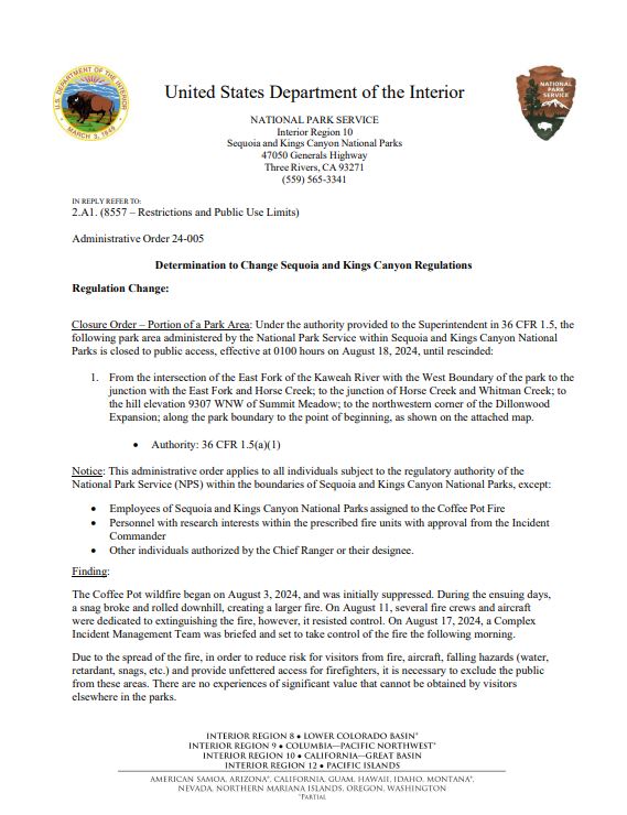
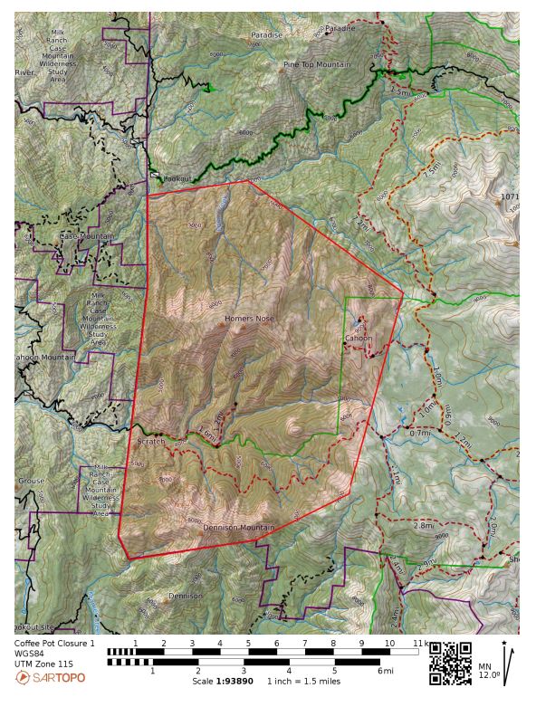
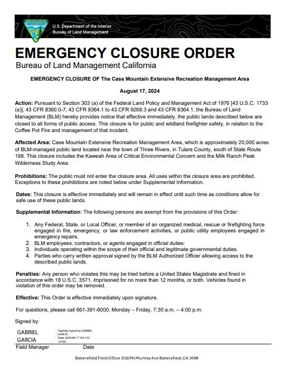
Coffee Pot Fire Closure Orders 08 17 2024
Related Incident: Coffee Pot Fire
Publication Type: Closures
Closure Order – Portion of a Park Area: Under the authority provided to the Superintendent in 36 CFR 1.5, the following park area administered by the National Park Service within Sequoia and Kings Canyon National Parks is closed to public access, effective at 0100 hours on August 18, 2024, until rescinded: 1. From the intersection of the East Fork of the Kaweah River with the West Boundary of the park to the junction with the East Fork and Horse Creek; to the junction of Horse Creek and Whitman Creek; to the hill elevation 9307 WNW of Summit Meadow; to the northwestern corner of the Dillonwood Expansion; along the park boundary to the point of beginning.
Action: Pursuant to Section 303 (a) of the Federal Land Policy and Management Act of 1976 [43 U.S.C. 1733 (a)], 43 CFR 8360.0-7, 43 CFR 8364.1 to 43 CFR 9268.3 and 43 CFR 8364.1, the Bureau of Land Management (BLM) hereby provides notice that effective immediately, the public lands described below are closed to all forms of public access. This closure is for public and wildland firefighter safety, in relation to the Coffee Pot Fire and management of that incident. Affected Area: Case Mountain Extensive Recreation Management Area, which is approximately 20,000 acres of BLM-managed public land located near the town of Three Rivers, in Tulare County, south of State Route 198. This closure includes the Kaweah Area of Critical Environmental Concern and the Milk Ranch Peak Wilderness Study Area.
Full orders attached.
Park Fire Evening Update 08 21 2024
Related Incident: Park Fire
Publication Type: News
Park Fire Evening Update for August 21 is posted on the Park Fire Status Update Page
Settings - change map background and toggle additional layers
Filter - control incident types displayed on map.
Zoom to your location
Reset map zoom and position
Could not determine your location.
Show Legend
 Wildfire
 Prescribed Fire
 Burned Area
Response
Burned Area
Response Other
Other
Parks Fire
Unit Information
Incident Contacts
BAER INFORMATION BRIEF Preparing for Rain After CA Wildfires 08 21 2024
Related Incident: Borel Post-Fire BAER
Publication Type: News
Burned Area Emergency Response (BAER)
Information Brief
PREPARING FOR RAIN AFTER CALIFORNIA WILDFIRES
BAER SAFETY MESSAGE: Everyone near and downstream from the burned areas should remain alert and stay updated on weather conditions that may result in heavy rains and increased water runoff. Flash flooding may occur quickly during heavy rain events-be prepared to act. Current weather and emergency notifications can be found at these National Weather Service websites: https://www.weather.gov/lox/, and https://www.weather.gov/sto/.
POST-FIRE WATERSHED CONDITIONS—KEY MESSAGES
While many wildfires cause minimal damage to the land and pose few threats to the land or people downstream, some fires cause damage that requires special efforts to prevent problems afterwards.
Summer monsoon thunderstorms and winter rain events in California mountain areas can result in high water runoff and flooding.
Wildfire increases the potential for flooding, post-fire soil erosion and debris flows that could impact campgrounds, fishing areas, homes, structures, roads, and other infrastructure within, adjacent to, and downstream from the burned areas.
Post-fire, watershed conditions will naturally receive and transport water and sediment differently than during pre-fire conditions.
The public and communities adjacent to and downstream from the wildfire areas should expect increased flooding and debris transport during less than average rain events.
SAFETY CONCERNS CONTINUE AFTER THE FIRE IS OUT
The potential for increased water runoff and debris flows are not just a one-year concern.
We recognize the threat potential of flash floods and debris flows may exist for the next several years, depending on the intensity of these storms.
For life and safety concerns, burned area public land closures are sometimes implemented prior to forecast rain events until the burned area fully recovers.
Residents and visitors should remain alert to weather events and plan ahead when travelling along roads within and downstream from the burned areas.
ASSESSING BURNED WATERSHEDS RESPONSE
Forest Service Burned Area Emergency Response (BAER) teams work with each of the national forests, to assess the condition of the watersheds on National Forest System (NFS) lands burned by wildfires.
BAER assessment teams identify potential emergency threats to BAER critical values that may be considered at-risk on federal lands such as:
- Human life and safety.
- NFS property, such as buildings, water systems and infrastructure, utility systems, road and trail prisms.
- Critical natural resources such as water, soil productivity and hydrologic function, areas where invasive species or noxious weeds may impact native or naturalized communities and may include critical habitat or suitable occupied habitat for federally listed threatened or endangered species.
- Critical cultural and heritage resources such as pre-historic and historic properties and sites.
BAER assessment teams recommend emergency stabilization response actions that are implemented on federal land to reduce potential post-fire threats.
PREPARING FOR POTENTIAL FLOODING AND DEBRIS-FLOWS FROM WILDFIRE BURNED AREAS
For values and resources potentially impacted off federal lands, one of the most effective BAER strategies is interagency coordination with local cooperators who assist affected businesses, homes, and landowners with preparing for rain events.
While multi-agency efforts are being taken to reduce the risks to life and safety adjacent to and downstream from the burned areas, nearby residents should develop individual plans to protect themselves and their property.
The USDA Forest Service and the USDA Natural Resources Conservation Service (NRCS) work together and coordinate with other federal, state and local agencies, and counties that assist private landowners in preparing for increased water run-off and potential flooding impacts.
NRCS and local sponsors prepare damage survey reports for eligible sites on private lands adjacent to and downstream from affected areas. NRCS uses these reports, along with the Forest Service BAER team’s assessment report, to develop emergency measures to reduce the impacts from potential increased water and debris flows, and assist local sponsors to implement recommended emergency measures through its Emergency Watershed Protection (EWP) Program: (NRCS_EWPP_Fact Sheet-2021.pdf (usda.gov)).
All EWP Program–Recovery projects begin with a local sponsor or legal subdivision of state or tribal government. Eligible sponsors include cities, counties, towns, conservation districts, or any federally recognized Native American tribe or tribal organization. Interested public and private landowners can apply for EWP Program–Recovery assistance through one of those sponsors. For more information on NRCS Disaster Assistance Programs: Emergency Watershed Protection | Natural Resources Conservation Service (usda.gov).
The following links provide information and references for state and local county offices of emergency management promote preparedness through its emergency services programs to assist the public to prepare for, respond appropriately to, and quickly recover from natural emergencies that may impact county residents and visitors:
Flood After Fire--California Toolkit
After the Fire—California Resources
California Current Road Conditions
Cal-Fire—Fire and Resource Assistance
California Governor's Office of Emergency Services
California Watershed Emergency Response Team (WERT)
Homes or businesses that could be impacted by flooding from federal land that resulted from wildfires may be eligible for flood insurance coverage from the National Flood Insurance Program (NFIP). Information about NFIP is available through FEMA at www.fema.gov/national-flood-insurance-program, or FEMA Wildfire Increases Flood Risk. Other flood preparedness information is available at www.ready.gov/floods and www.floodsmart.gov/.
LINKS TO ADDITIONAL RESOURCES AND WEBSITES
NRCS Wildfire Disaster Recovery
NRCS Post-Fire Disaster Assistance
FEMA Wildfire Increases Flood Risk
FEMA Flood After Fire—Fact Sheet
Recovering from Wildfire-Damage Assessments
Flood Safety Emergency Preparedness
Be Ready & Prepare for Emergencies
NWS Weather Information—Los Angeles CA
NWS Weather Information—Sacramento CA
NWS Post-Wildfire Flash Flood-Debris Flow Guide
NWS Burn Scar Flash Flood & Debris Flow Risks
Red Cross Emergency Preparedness
###
Cottage GroveLane 1 Fire Update 08 21 2024
Related Incident: Lane 1 Fire
Publication Type: News
Warmer conditions help firefighters locate remaining hotspots on Lane 1 Fire
COTTAGE GROVE, Ore. – An increase in temperatures is aiding firefighters on the Cottage Grove – Lane 1 Fire, allowing for better conditions during mop-up efforts across the fire. While rain over the weekend was beneficial in decreasing fire behavior, it also made locating any lingering burning material and heat difficult for resources on the line. As vegetation dries out, these embers will begin to smolder and smoke once again, alerting firefighters to their presence.
In the meantime, resources have been using a variety of infrared (IR) tools to detect heat. These practices will continue, ensuring a thorough mop-up process. Across the incident, firefighters are pushing 200-300 feet into the interior of the fire, creating a solid barrier all the way around. As this work continues, containment increases with the progress made. This morning, the fire is 74% contained.
Fremont County PreEvacuation Notice for US HWY 26287 Corridor 08 21 2024
Related Incident:
Publication Type: Announcement
Jackson, Wyo., August 21, 2024 – Strong winds produced large growth of the Fish Creek Fire on the Jackson Ranger District of the Bridger-Teton National Forest on Wednesday, August 21, 2024. Dry conditions and strong winds are expected to continue throughout the week, which may increase fire growth.
Fremont County has coordinated pre-evacuation notices and utilizes the “Ready, Set, Go!” alert system. See the alert notice on the Fremont County Fire Protection District Facebook page, which reads:
“On the authority of Deputy Fremont County Fire Warden, Ron Wempen; due to the increasing threat of the Fish Creek Fire west of Dubois, a Level 2 Evacuation Notice is now in effect for the following areas: US Highway 26/287 in the area of Mile Post 30, 31, 32, 33, 34, and 35. This also includes the following roads, houses, dwellings, campgrounds, and trailheads.
- Brooks Lake Road to include Brooks Lake Lodge
- West Pinnacle Dr.; all homes and/or dwellings
- East Pinnacle Dr.; all homes and/or dwellings
- Pinnacle Lane; all homes and/or dwellings
- Breccia Drive; all homes and/or dwellings
A Level 2 Evacuation means “Be Set” to evacuate. You must prepare to leave at a moment’s notice. This level indicates there is significant danger to your area, and residents should either voluntarily relocate to a shelter or with family/friends outside of the affected area, or if choosing to remain, to be ready to evacuate at a moment's notice.”
Residents and recreationalists are encouraged to learn more about the “Ready, Set, Go” alert system.
- Ready, Set, Go! Fremont County, WY: fremontcountywy.org/government/departments/emergency_management/index.php
- Ready, Set, Go! Teton County, WY:
tetoncountywy.gov/1846/Ready-Set-GO
The lightning-caused Fish Creek Fire was discovered on Friday, August 16, in a remote area of the North Fork Fish Creek drainage, approximately 7 miles southwest of Togwotee Pass, and is currently 5,248 acres in size burning in heavy timber and dead and down fuels.
Smoke from the fire may be visible from Grand Teton National Park and Moran, Dubois, Jackson and Pinedale, WY. Firefighters are working to suppress the fire and keep it from moving towards infrastructure against the Forest boundary. Learn more at https://inciweb.wildfire.gov/incident-information/wybtf-fish-creek-fire.
The Fish Creek Area, Roads, and Trails Closure Order (map) has been established for public and firefighter safety. See full details at https://www.fs.usda.gov/alerts/btnf/alerts-notices.
Smoke from the Fish Creek Fire is impacting US Highway 26/287. Please drive slowly and cautiously in the area with your headlights on.
For other news, events and information about the Bridger-Teton National Forest, call 307-739-5500, visit the Forest website at https://www.fs.usda.gov/btnf and follow the Bridger-Teton on Facebook and X (formerly Twitter) @BridgerTetonNF.
USDA is an equal opportunity provider, employer and lender.
#####
North Willamette Complex Ore and Pyramid Fires Daily Update 08 21 2024
Related Incident: North Willamette Complex
Publication Type: News
Willamette Complex North
Daily Update
2024.WillametteComplex.North@firenet.gov
Information line: 541-208-1262, 8 am to 8 pm
Facebook: facebook.com/OreFireInformation2024
Inciweb: inciweb.wildfire.gov
August 21, 2024
This morning, command of the Willamette Complex North (Pyramid and Ore fires) transferred to Northwest Complex Interagency Incident Management Team 7, Chris Orr, Incident Commander.
SPECIAL NOTE: State Route OR-126 will be closed for 48 hours from 7 a.m. 8/20 through 7 a.m. 8/22 for road repaving from mile marker 13 to 19.8. This will impact travel to and east of Belknap Springs. OR-20 and OR-58 are recommended as full detours around the closure; vehicles over 35 feet long are not allowed on OR-242.
CURRENT SITUATION: Conditions will be slightly cooler with higher humidity today leading to reduced fire spread probability, with increased chances of a wetting rain late today and into Thursday night. A drying trend is expected to begin over the weekend.
Ore Fire: Blue River, 3,147 Acres, 14% Contained, 571 Total Personnel, Human Caused. Overnight resources continued to secure containment lines. Current weather and fuel conditions do not support the additional firing operations required to complete securing the fire perimeter. Crews on the northeastern flank will continue to construct and improve containment lines. The southwestern and southeastern flanks remain a solid anchor for the fire.
Pyramid Fire: East of Middle Santiam Wilderness, 1,312 Acres, 82% Contained, 355 Total Personnel, Lightning Caused. On the west and northwest of the fire, work continues on the shaded fuel break, roadside brush chipping, and removal of fire fuels and woody debris. Crews continue to secure containment lines and clean up contingency lines.
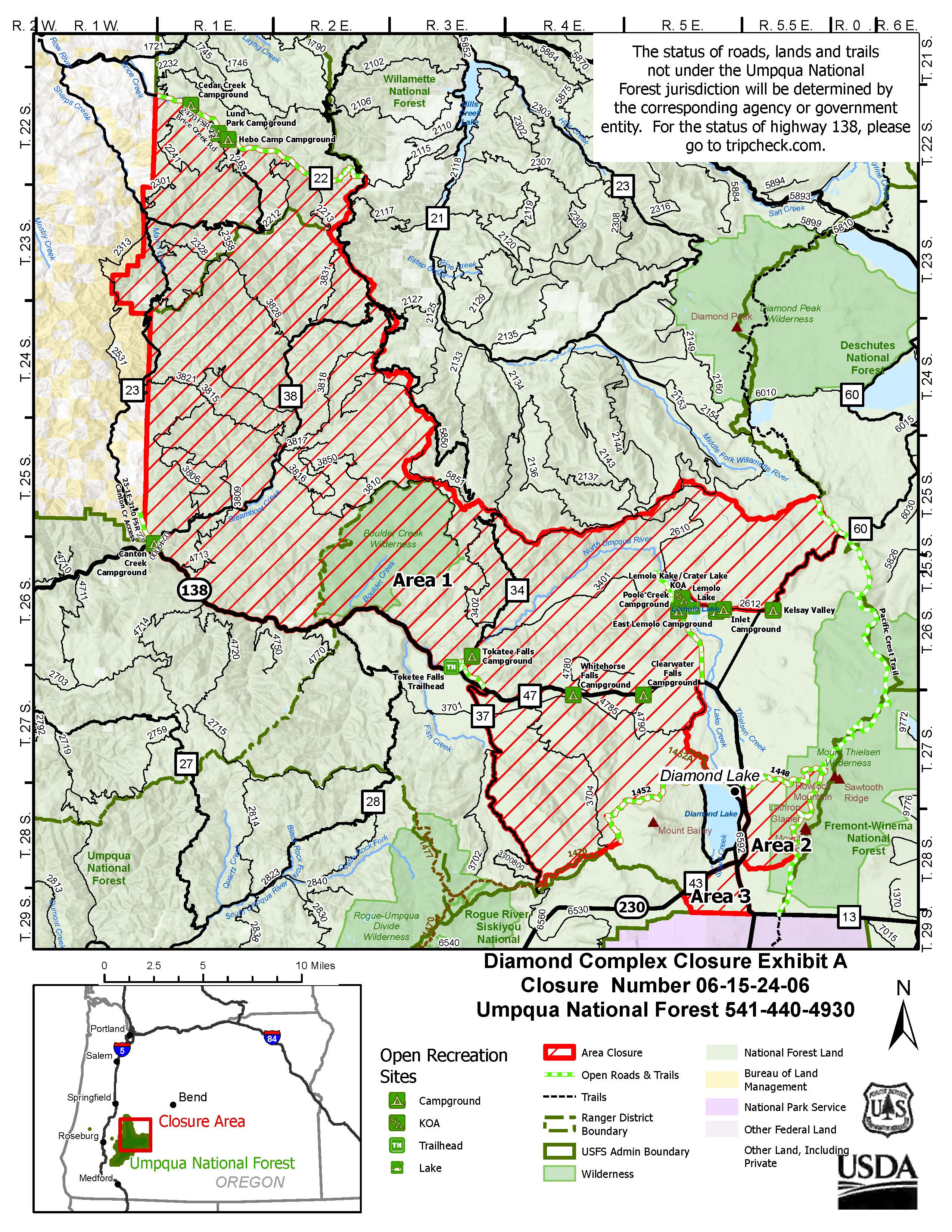
EVACUATIONS CLOSURES, & FIRE RESTRICTIONS: Update 8/19/2024: The Linn County Sheriff's Department cancelled the Level 3 evacuation order on August 19, 2024. Please refer to the Linn County Fire Map for current status. Areas within the rescinded Evacuation Order remain closed under the Pyramid Fire Area Closure Order (see below).
Area, road, trail, and recreation site closures are in effect on the Willamette National Forest. The Pyramid Fire closure area was reduced on August 19. Specific information is posted at https://www.fs.usda.gov/alerts/willamette/alerts-notices/?aid=61574. Please see Pyramid Fire Area Closure Forest Order and the Ore Fire Area Closure Forest Order.
Due to hot and dry conditions, all campfires, charcoal fires, pellet fires, or any other open fires are prohibited, including in developed campgrounds and wilderness areas. Pressurized liquid or gas stoves, lanterns, and heaters that can be switched on and off are allowed. Please see Forest Order 06-18-00-24-27 for additional information.
ROADS: When traveling in the area, please be mindful of firefighters and their vehicles working near roads. Please visit the Oregon Department of Transportation website for current road conditions.