
Middle Fork Complex Wapiti Bull Trout Fire Update for Wednesday 08 21 2024
Related Incident: Bulltrout Fire
Publication Type: News
Incident Commander: Rick Connell, Northern Rockies Team 5
Locations:
- Middle Fork Complex Location: 9 miles east of Garden Valley, ID
- Bull Trout Location: 15 miles WNW of Stanley, ID
- Wapiti Location: 2 miles southwest of Grandjean, ID
Start Dates: 07/24/24 – 08/06/2024
Cause: Lightning
Size:
- Bull Trout: 271 acres
- Wapiti: 17,520
- Middle Fork Complex: 31,087
- Bulldog: 5,801
- Nellie: 25,286
Containment:
- Middle Fork Complex: 5%
- Wapiti: 10%
- Bull Trout: 92%
Resources on site:
- Middle Fork Complex: 6 type 2 hand crews; 10 engines; 2 water tenders
- Wapiti: 3 hot shot crews; 3 type 2 hand crews; 24 engines; 3 water tenders; 1 skidgen
- Bull Trout: 1 type 2 crew; 1 engine
Total Personnel:
- Middle Fork Complex: 362
- Wapiti: 228
- Bull Trout: 39
KEY MESSAGE:
Yesterday afternoon, the Boise County Sheriff’s Office issued a mandatory evacuation order for the Danskin area north of Highway 17 and the community of Hanging Valley is in Level 3 “GO” evacuation status due to the Highway 21 closure. Evacuation information will be posted on the Boise County Sheriff’s Office Facebook page. For closure information, please visit Boise National Forest’s website – Alerts & Closures. Smoke will be visible and could impact roadways today, please follow the instructions of emergency responders and drive safely.
There will be Community meeting in Stanley tonight at 6:00 p.m. at the Stanley Community Center at 500 Eva Falls Avenue, Stanley, Idaho.
The Middle Fork Complex will be transitioning to two incident management teams in the next couple days. Great Basin Team 3 will assume command of the Middlefork Complex (Bulldog and Nellie Fires) Friday morning at 6 am and Rocky Mountain Team 1 will assume command of the Wapiti Fire on Sunday at 6 am.
CURRENT STATUS/PLANNED ACTIONS:
Middle Fork Complex: The Middle Fork Complex is comprised of the Bulldog and Nellie fires.
On the Bulldog Fire, crews are progressing north on FS road 698 and holding the fire on the east side. Firefighters will be in the area of Silver Creek conducting wildland urban interface assessment. This includes inventory of homes and structures, assessing hazards such as fuel tanks and firewood piled near structures to develop the best strategy to place fireline, hoses, and sprinklers needed to support wildland fire actions. Firefighters are continuing to improve and hold direct and indirect lines. The public is reminded that the Middlefork Road (FS Road 698) is closed at the Forest Service boundary just north of Lightning Creek and the Scriver Creek Road (FS Road 693) is also closed at the Forest Service Boundary for firefighter and public safety as crews continue to work to protect private property and structures in the vicinity of Crouch.
On the Nellie Fire, critical weather conditions and active fire behavior occurred throughout the day and into the evening yesterday and the fire grew over 5,000 acres to the north and south. Engines, heavy equipment, and aircraft are working along Highway 17 in the Danskin area. Crews are planning to construct a fireline on the southwest side of the fire along the highway, moving north. The fire continues to grow to the north between the Rattlesnake Fire burn area to the east and the Pioneer Fire area to the west. Firefighters are working at the Deadwood Reservoir to provide for infrastructure protection within the wildland urban interface. The public is reminded that Forest Service Road #555 is closed at the intersection of Highway 17 all the way to the Forest Service Road #579 intersection.
Wapiti Fire: The Wapiti Fire continues to grow with active fire behavior with group torching, long range spotting, and terrain driven runs. Yesterday the fire grew over 8,000 acres. Firefighters conducted strategic firing operations to limit the spread to the northwest, consuming fuels between the active fire and the 2003 Canyon Creek Fire area. Crews continued to mop-up fire and hotspots throughout the day and night for Sawtooth Lodge, Bear Creek, Camp Creek, and Wapiti Creek Summer Home areas. Fire is expected to continue to spread downhill and along the ridge lines to the west and north. Firefighters will continue to operate along Highway 21 to prevent the fire from impacting the highway and growing to the west. Today, crews will be staffing the northeast end of the fire, addressing the potential for growth towards Stanley Lake in the Sawtooth National Forest. Two handcrews, heavy equipment and engines are positioning in the Stanley Lake area to take action when the fire approaches the lake, including the Stanley Creek, Ironwood, and Goat communities The Sawtooth National Forest is closing the Stanley Lake Recreation Complex and connecting trails for public safety. Highway 21 remains closed from MP92 to MP107 from the Grandjean area to the Custer County line due to wildfire activity. This area starts at Forest Road 025RC (MP 92), which accesses Warm Springs Guard Station and air strip to the Custer County line MP107.
Bull Trout Fire: The Bull Trout fire is still 92% contained, with little heat observed yesterday. An engine continues to patrol the fire daily to ensure no changes in activity.
WEATHER AND FIRE BEHAVIOR:
Elevated to critical fire weather conditions are expected this afternoon and evening. The morning inversion will lift during the early afternoon hours, with relative humidity values will decrease by 3 pm. Winds will remain terrain driven through the morning, becoming southwesterly at 5-10mph with gusts up to 18. High slopes, ridgelines, and aligned drainages will see gusts up to 25 mph. Afternoon temperatures will be a couple degrees cooler than yesterday as scattered cumulus development is expected to develop in the afternoon like the last few days. Hot, breezy conditions persist, aiding in large fire growth. Group torching, spotting with wind, and terrain influenced growth is again expected once the inversion lifts.
CLOSURES, RESTRICTIONS, AND EVACUATIONS:
Middle Fork Complex: The Boise County Sheriff's Office continues to maintain the Level 2 evacuation notice for residents on and near the Middlefork Road between Stump Ranch Road up to Tie Creek Campground. The Boise National Forest issued an area closure for the fire (Closure #0402-06-59) effective August 12, 2024. The purpose of this order is to protect public safety during the fires.
Wapiti Fire: The evacuation order for Summer Homes and the Sawtooth Lodge remain in effect for the Wapiti Fire, as does the area closure issued by the Sawtooth and Boise National Forests (Closure #0402-05-94) effective August 12, 2024. This Order is for public and firefighter safety during fire suppression efforts of the Wapiti Fire.
Bull Trout Fire: The Bull Trout Fire Area Closure (Closure #0402-05-93) remains in effect for the roads and trails within the perimeter of the fire. The Boise National Forest issued this order on August,12, 2024. It will be rescinded as soon as it is safe to do so.
Closure information and maps are posted on the Forest’s website and the fire’s Inciweb page as they are in place. https://tinyurl.com/2u8v3pf7
The Boise National Forest, Idaho Department of Lands, and Bureau of Land Management are in Stage 1 fire restrictions on state, endowment, private and federal lands within the West Central Mountains Fire Restrictions Zone. For more information on the restrictions and a map visit:
https://www.idl.idaho.gov/fire-management/fire-restrictions-finder/
21 de agosto de 2024 Actualizacin diaria de los incendios Whisky Creek y Sandstone 08 21 2024
Related Incident: Whisky Creek FireSandstone Fire
Publication Type: News
Whisky Creek Tamaño: 2,058 acres | Fecha de inicio: 20 de julio | Causa: De orígen humano, a ser determinada | Contención 9% Sandstone Tamaño: 702 acres | Fecha de inicio: 5 de agosto | Causa: Rayo | Contención: 29% Total de recursos: 780 | Equipos de obreros: 18 | Camiones de bomberos: 11 | Topadoras: 5 | Otras maquinarias pesadas: 31 | Helicópteros: 4
(Odell, Oregón.) – El trabajo de extinción sigue en el incendio Whisky Creek, a 6 millas al sureste de Cascade Locks, Oregón, y en los incendios Sandstone y Blister Creek, a 9 millas al suroeste de Ripplebrook, Oregón. Estos arden en un terreno escarpado y accidentado en el Bosque Nacional Mt. Hood, donde los escombros rodantes y los árboles debilitados por el fuego dificultan el trabajo de extinción. La seguridad de los bomberos y la del público siguen siendo la principal prioridad. Los encargados de los incendios están aprovechando las condiciones climáticas buenas para evaluar y desarrollar planes para realizar esfuerzos más directos de extinción. Debido a varios factores, algunos incendios forestales consumen la mayoría de los combustibles dentro de sus bordes. Los incendios Whisky Creek y Sandstone han llevado a patrones en forma de mosaico en los que los parches quemados de vegetación y vegetación no quemada contribuyen a un paisaje que fomenta la diversidad forestal, apoya los hábitats de la vida silvestre y minimiza la propagación de futuros incendios forestales.
Whisky Creek: Ayer, las cuadrillas continuaron neutralizando las líneas de contención a lo largo del extremo este del incendio mientras que removían árboles peligrosos. Realizaron más neutralización cerca de Black Lake. En el extremo sur del incendio, donde se concentra la intensidad del fuego, los bomberos exploraron opciones para cortafuegos cerca de Tomlike Mountain.
Hoy, trabajarán para fortalecer las líneas de contención existenes. Los operadores de maquinarias pesadas utilizarán trituradoras, tractores y taladores de árboles para procesar los desechos generados por la extinción, convirtiéndolos en material más controlable y menos inflamable.
Sandstone & Blister Creek: Ayer, al sur del incendio Blister Creek, los helicópteros vertieron más de 11,000 galones de agua en el desague de Blister Creek, donde el terreno extremo impide que los equipos de tierra lleguen de manera segura al borde del incendio. El trabajo de trituración continuó a lo largo del camino forestal 7010, ya que los bomberos reforzaron las líneas de contención desde el camino forestal 7010 hacia el norte. En la parte noreste, el personal avanzó mucho en preparar la carretera forestal 4620 como elemento de contención.
Hoy, los recursos aéreos se enfocarán en las partes no contenidas del incendio Blister Creek, utilizando monitoreo y vertiendo agua de manera específica para limitar la propagación del fuego. Se utilizará maquinaria pesada para mejorar las carreteras y retirar los grandes escombros leñosos. A medida que mejora la contención, el equipo extra se devolverá al campamento, se le dará una buena limpiada y se volverá a usar según sea necesario.
Clima y comportamiento del fuego: Las temperaturas más frescas, la mayor humedad y los cielos parcialmente nublados continuarán moderando la intensidad del fuego. Se desplazará al áreas un frente frío del norte, trayendo una mayor probabilidad de lluvias dispersas esta noche y el fin de semana.
Seguridad: El público juega un papel importante en la prevención del próximo incendio forestal. Tenga cuidado con cualquier fuente de ignición. Para obtener consejos de prevención, visite, https://keeporegongreen.org. Hay restricciones contra incendios dentro del Bosque Nacional Mt. Hood. Se puede ver más información enhttps://www.fs.usda.gov/main/mthood/fire. Se ha establecido una restricción temporal de vuelo (TFR) en ambas áreas de incendio.
Humo: Se espera que la calidad del aire sea buena para ambas áreas de incendio. Para ver más información sobre las condiciones del humo en su área, visite: www.AirNow.gov.
Cierres: Información sobre el cierre del Bosque Nacional Mt. Hood y el Área Escénica Nacional del Río Columbia se puede encontrar en escaneando el código QR o siguiendo el enlace en la esquina inferior derecha de la página. Los cierres se implementarn para la seguridad del público y de los equipos de bomberos.
Para más información sobre los incendios de Whisky Creek y Sandstone, consulte los siguientes recursos:
Correo electrónico: 2024.whiskycreek@firenet.gov or 2024.sandstone.or@firenet.gov Teléfono: 541-208-1743, 8 a.m. – 8 p.m. Sitio web: Escanea el código QR a la derecha o vaya a https://linktr.ee/whisky_creek.2024
Williams Mine Fire Update 08 21 2024
Related Incident: Williams Mine Fire-GPNF
Publication Type: News
KEY MESSAGES:
Specialized equipment such as chippers and dump trucks are working through the road systems to facilitate slash removal. The Williams Mine Fire is slowly reducing other firefighting resources from the operation as containment continues to increase.
The temporary flight restriction (TFR) is being reduced in size to better suit aerial operational needs. Three aircraft remain on the incident with a Type 3 helicopter stationed in Trout Lake for shorter response times if needed.
CURRENT STATUS:
Strategic mop-up operations from hand and dozer line will continue until the perimeter is secure. The structure/contingency group is utilizing masticators to protect the Glacier Springs-water system.
Fire managers took advantage of favorable weather and implemented tactical firing operations from a prepared dozer line in the Buck Creek drainage. These firing operations burned compact litter with heavy down and dead fuels to create containment lines from isolated fire perimeter to a defined control feature meeting incident objectives. A straight line of black (fire edge) limits the probability of reignition which provides firefighters the needed depth to establish containment and begin mop-up. Incident officials expect the containment percentage to continue climbing at a steady rate over the coming week as firefighters continue perimeter security along the fire edge.
WEATHER / FIRE BEHAVIOR:
Early morning hours will have favorable weather to start the day. As the day progresses there will be a potential for isolated showers through the afternoon hours. Relative humidity values will reach 50-60%. The best chance for showers and isolated thunderstorms arrives tomorrow evening and remains possible into Friday morning. However, fire can remain on the landscape and smolder until warm temperatures rise where fire behavior potentially could increase.
SAFETY AND CLOSURES:
Washington DNR managed lands near Trout Lake and Glenwood are closed to entry due to the Williams Mine Fire. For more information, please see http://www.dnr.wa.gov/ahtanum. The Confederated Tribes and Bands of the Yakama Nation, Tract D Recreation Area is closed, please see Yakama Tract D Road Closure for more information. Level 1 & 2 evacuations are in effect for the community of Trout Lake, and parts of Klickitat County. Evacuations are coordinated through the Klickitat County Sheriff’s Office and the Skamania County Sheriff’s Office. The FS-23 and FS-25 roads are closed, see the Williams Mine Area and Road Closure for more details. The Pacific Crest Trail (PCT) is closed from the PCT's intersection with FS 23 to Potato Hill. The current area closure spans the entire Mt. Adams Wilderness.
Media Update 82124 Dixon Fire 08 21 2024
Related Incident: Dixon Fire
Publication Type: News
Containment reaches 100% on Dixon Fire
DAYS CREEK, Ore. – By meeting the mop up standard set by local agencies, the Oregon Department of Forestry Incident Management Team 2 (ODF IMT 2) will transfer command of the Dixon Fire to a local Type 4 organization. The local Type 4 organization, led by Incident Commander Tray Babikoff, is comprised of local resources from the Umpqua National Forest and Douglas Forest Protective Association.
Black Mountain Fire Closure Rescinded 08 21 2024
Related Incident: Black Mountain
Publication Type: Closures
Pursuant to Title 36 Code of Federal Regulations 261.50 (a), the prohibitions listed in Order number 01-15-14-24-20 (dated August 13th, 2024) applicable to the Helena – Lewis and Clark National Forest and signed by Emily Platt Brownscombe are hereby terminated.
Executed in Helena, Montana, this 21st day of August, 2024, and effective as of this date.
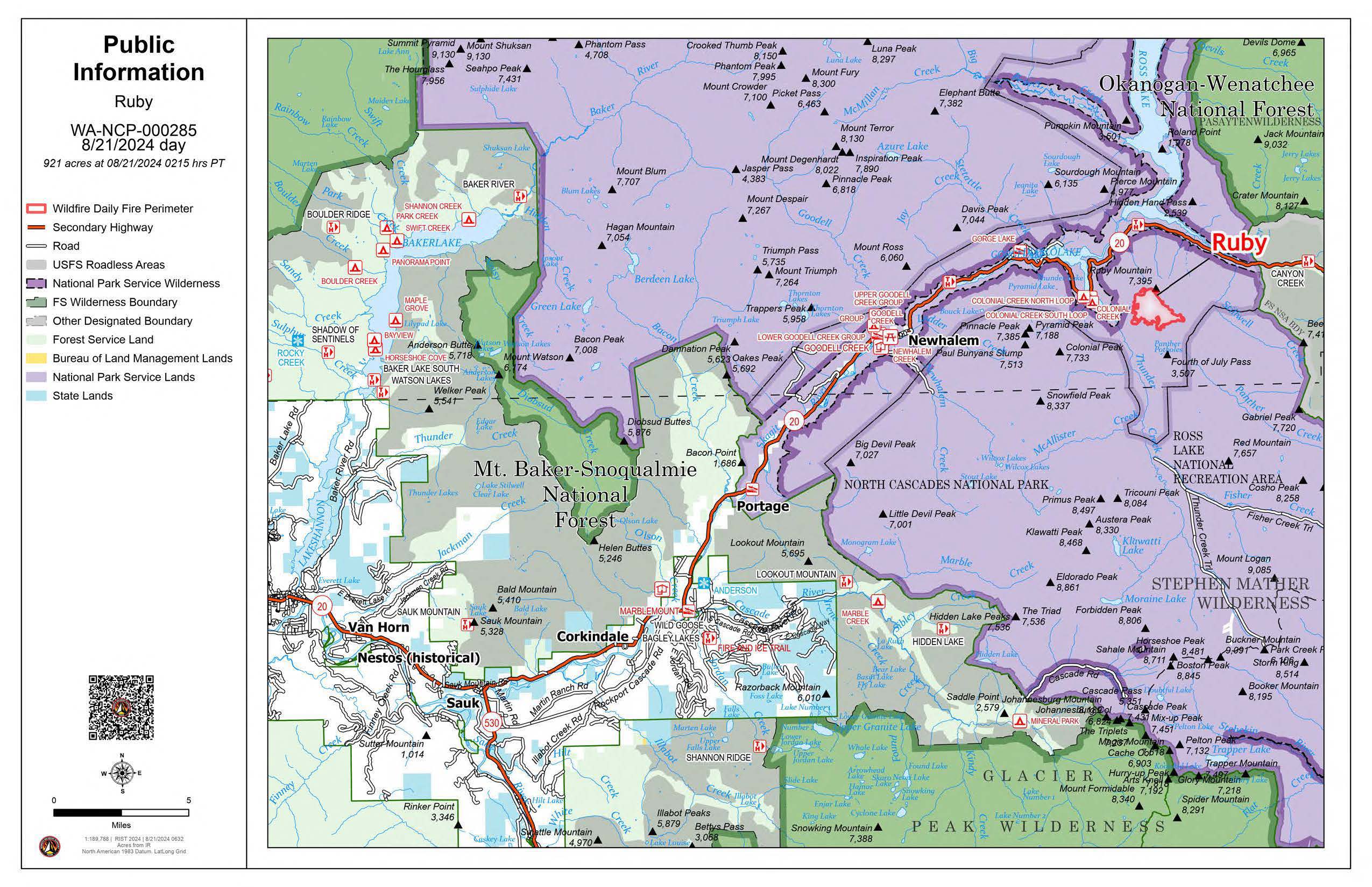
Ruby Fire Update and Map August 21 2024 08 21 2024
Related Incident: Ruby Fire
Publication Type: News
Ruby Fire Quick Facts
Size: 921 acres Location: North Cascades National Park, Ruby Mountain, Diablo, Washington
Containment: 0% Cause: Lightning/Natural
Start Date: August 9, 2024 Total Personnel: 93
Fire Information:
Inciweb: https://inciweb.wildfire.gov/incident-information/wancp-ruby-fire Email: 2024.Ruby@firenet.gov
Facebook: https://www.facebook.com/people/Ruby-Fire/61563760546137
Phone: 1-360-208-8096
Current Status: A Type 3 Incident Management Team under Incident Commander Shawn Turner will shadow the Minnesota Incident Command System (MNICS) Team today and take command of the Ruby Fire at 6:00 am on Thursday. Shadowing helps with a smooth transition from one team to another with the transfer of the current strategic situation that has taken place over the team’s tenure. Firefighters continue preparing values at risk and developing contingency plans.
Planned Actions: Firefighters will continue to protect critical infrastructure, park campgrounds, trails, backcountry camps, and other resources in preparation for possible fire growth. The Ruby Fire is a full suppression fire, and firefighters are utilizing strategies and tactics that provide the highest likelihood for success, while mitigating risks to firefighters and the public. The main objectives are protecting human life, minimizing damage to values at risk, and limiting wildfire spread to the north and west.
Weather: Wednesday, cloudy with a 70% chance for rain showers and thunderstorms. High near 68. Southerly winds 4 to 7 mph gusting to 10 mph. Evening and night, cloudy with a 55% chance for rain showers and thunderstorms. Lows near 58. There is a risk of thunderstorms in the fire area for the rest of the week.
Closures: There are multiple closures in place for public safety. Colonial Creek South Campground and boat launch, Thunder Arm south of Diablo Lake, and State Route 20 east of the park from MP 148 and MP 157, are closed. For a full list of closures visit https://go.nps.gov/fireclosures.
Burning Restrictions: Campfires, the ignition of wood, briquettes, or any fuel in fire pits, fire pans and barbeque grills, are banned in all portions of North Cascades National Park Service Complex: North Cascades National Park, Ross Lake National Recreation Area, and Lake Chelan National Recreation Area.
Drone Restrictions: Drones can seriously impact the safety of firefighting efforts, and operating drones within North Cascades National Park is prohibited, except with prior written approval from the superintendent.
Cooperating Agencies & Tribes: National Park Service, Upper Skagit Indian Tribe, Seattle City Light, Whatcom County, Whatcom County Sheriff’s Office, Washington State Dept. of Transportation.
Smoke: U.S. Interagency Wildland Fire Air Quality Response Program - Overall air quality will be good today in upper Skagit Valley. https://outlooks.wildlandfiresmoke.net/outlook/f79a6d6d
https://www.airnow.gov/
If you would like to sign up for our daily updates, please send an email to: 2024.Ruby@firenet.gov
Homestead Complex Fire Update 08 21 2024
Related Incident:
Publication Type: News
No Man, Salmon 33, Horse Heaven Creek, Bullpup, Fuller Lake, Reynold’s Butte, Lost Bucket
Start date: July 19, 2024 | Location: Northeast of Glide, Oregon | Total Personnel: 956
Total Homestead Complex Fire size: 5,880 acres | Cause: Lightning | Containment: 35%
Summary
Fire activity on the Homestead Complex was limited to smoldering and creeping with slow rates of spread on Tuesday. Overnight recoveries reached 100% last night which will make fire growth less active for today’s operational period, seeing rates of spread reduced to limited surface activity of a few inches a minute in areas.
No Man (2,080 acres) and Salmon 33 (261 ac.): In addition to working toward completion of indirect perimeter control lines, improvement of primary lines will continue by using heavy machinery like chippers and masticators, reducing the amount of vegetation along those lines. Backhauling of hose and other equipment will continue on the Salmon 33 Fire.
Horse Heaven Creek Fire (2,288 ac.): Crews will work to improve existing lines and will look for opportunities to construct new lines on the west side of the fire.
Bullpup Fire (474 ac.) and Fuller Lake Fire (409 ac.): Firefighters will work to improve primary firelines and they will also continue prepping alternate control lines with heavy equipment, fallers, and crews.
Reynolds Butte Fire (334 ac): An engine crew will continue to patrol the fire perimeter today, with limited mop up.
Lost Bucket Fire (34 ac.): 100% contained on July 29, 2024.
Weather: Today is anticipated to be slightly cooler than yesterday. Temperatures will be in the mid 60s to lower 70s with relative humidities in the high 30s and 40s with a max of 50% along ridge tops. Winds will be light and variable in the morning, switching to the west with gusts of 15 in the afternoon.
Closures and Fire Restrictions
The Bureau of Land Management (BLM), Roseburg District, has issued a closure order for portions of BLM land which border the Umpqua National Forest Emergency Fire Closure north of Steamboat. The closure order can be viewed here: https://www.blm.gov/sites/default/files/docs/2024-07/orwa-fpo-rbg-072624.pdf.
The Umpqua National Forest has Emergency Fire Closures in place impacting every district of the forest. https://www.fs.usda.gov/alerts/umpqua/alerts-notices.
There is a Temporary Flight Restriction (TFR) over the Homestead Complex Fire. Please remember, if you fly we can’t! If a drone or other aircraft enters the air space, all firefighting aviation equipment will be grounded.
Easy Fire Update 08 21 2024
Related Incident: Easy Fire
Publication Type: News
Easy Fire Update
August 21, 2024
Quick Facts
Size: 2,130 acres
Start Date: July 17, 2024
Location: 17 miles west of Mazama, WA
Containment: 36%
Personnel Assigned: 115
Cause: Lightning
Resources Assigned: 2 crews, 5 engines, 5 water tenders
This will be the final daily fire update on the Easy Fire unless conditions change.
Virtual Community Briefing on Wednesday, August 21, at 5:30 p.m.- on the Pioneer and Easy Fires Information Facebook Page at facebook.com/profile.php?id=61560760893080 Please submit questions in advance to 2024.pioneer@firenet.gov or via Facebook Messenger.
CURRENT SITUATION: Recent wet weather and cooler temperatures have helped to moderate fire activity on the Easy Fire. Firefighters on the ground, aided by helicopters dropping water from the air, have successfully held the fire within its current footprint over the last several days. Steep, inaccessible terrain and overhead hazards including snags and potential for rolling debris limit firefighters ability to access parts of the fire. Resources have secured areas of the fire along Highway 20 and within Swamp Creek drainage where safe to do so. Where the fire has not reached the highway, the forest along the roadway has been prepared to receive fire by removing heavy concentrations of vegetation to limit fire activity should the fire spread that direction. Natural features on the north and south are also being used to limit fire spread on the Easy Fire.
The Easy Fire will be on the landscape until there is a significant change in the weather pattern like multiple consecutive days of wetting rain that typically signify the wind down of fire season. Visitors to the area will continue to see smoke interior to the fire as heavy fuels continue to burn and smolder. Firefighters will patrol the fire to ensure that any heat stays within the current fire footprint.
TODAY’S ACTIVITIES: Today firefighters will continue using Unmanned Aircraft Systems (UAS) to search for any residual hot spots. Aided by strategically placed water bucket drops, firefighters will work to extinguish any heat that might contribute to fire spread. Firefighter crews will also continue to coordinate with Washington Department of Transportation to remove debris that resulted from last week’s mudslides and clear ditches along Highway 20.
WEATHER: Temperatures will be in the 60s to low 70s and there is a 50% chance of rain today.
CLOSURES: Highway 20 is closed in both directions between Granite Creek (Mile Post 148) and Rainy Pass (Mile Post 157): Stay up to date on the closure by checking the Washington Department of Transportation Facebook page for updates and viewing current highway conditions at wsdot.com/Travel/Real-time/Map/.
The Okanogan-Wenatchee National Forest has closures in place for trails within the fire area, for more information visit Okanogan-Wenatchee National Forest - Alerts & Closures (usda.gov). This closure includes a portion of the Pacific Crest Trail and more information may be found at https://closures.pcta.org. Campfires are prohibited. There is a Temporary Flight Restriction (TFR) in place over the fire: tfr.faa.gov/save_pages/detail_4_2247.html
EVACUATIONS: There are no evacuations in place for the Easy Fire. Anyone recreating in the area should be vigilant of surroundings and stay out of closed areas.
InciWeb: https://inciweb.wildfire.gov/incident-information/waowf-easy-fire
Facebook: https://www.facebook.com/profile.php?id=61560760893080
Fire Information Line: 541-861-5808, 8 a.m. to 8 p.m.
Email: 2024.easy@firenet.gov
Diamond Complex and Middle Fork Daily Update 08 21 2024
Related Incident: Middle Fork Fire
Publication Type: News
Our primary mission on the Diamond Complex and Middle Fork Fire is to serve the public with dedication and compassion. With your safety and the safety of our firefighters in mind, we are committed to addressing the needs and concerns of your communities by managing and controlling the fires to keep your forests, parks, and natural areas safe and enjoyable. Using safe and aggressive firefighting suppression methods our goal is to help you return to enjoying the outdoors.
The Diamond Complex in the Umpqua National Forest consists of 29 lightning-caused fires totaling approximately 10,987 acres and is 38% contained. Twenty-three of the original 29 fires in the Diamond Complex are now 100 percent contained. The Twin Knobs fire that we reported yesterday is 100% contained at .37 acre.
The Middle Fork Fire in the northwest corner of Crater Lake National Park is 5,228 acres and is 0% contained. The fire is primarily burning within the 2015 National Creek and 2017 Spruce Lake fire scars. There was minimal smoke or fire activity as the fire continued to creep at a slow rate of spread. There remains an extreme hazard of falling trees that were destroyed in both the 2015 and 2017 fires.
OPERATIONS:
Middle Fork Fire: (5,228 acres, 0% contained):
Today, crews will continue removing heavy timber and vegetation along the 230 Road and at the north entrance to Crater Lake National Park. On the southern side, crews will continue to look for areas of opportunity to limit fire spread and make trails more defensible to the south. Specialty teams have been deployed and will be embedded for the next few days to evaluate opportunities for direct suppression operations such as removing fuel or constructing a line around the area. The park remains open.
Diamond Complex Fires:
Pine Bench Fire (North of Hwy 138 near Dry Creek, 3,925 acres, 30% contained):
There was limited smoke, fire activity and no concerns with containment; however, hoselines remain in place. Hand crews and dozers pushed into the lower portion to control the East and West edges of the fire. The spot fire in Slide Creek is under control and hose lines are in place. Today’s priority will be to continue containment into Medicine Creek. Crews will continue improving the road from the west side, moving north.
Potter Fire (North of Hwy 138, two miles southeast of Potter Mountain, 3,320 acres, 6% contained):
On the north side, Hot Shots and Dozer operations are working down to Noisy Creek and securing the North. Crews are still facing an extreme hazard of falling trees. Crews will continue to clear vegetation along the 265 Road, and prep the roads to the East and to the West.
Trep Fire (About four miles south of Hwy 138, 544 acres, 0% contained):
Resources will continue their efforts to improve conditions along the northern perimeter and extend current handlines. In the south, crews will be working on extinguishing hot spots, conducting patrols and holding the fire west of Bear Creek Drainage.
Other fires within the Diamond Complex:
Lost Fire (Northeast of Trep Fire, 64 acres, 100% contained):
Ooya Fire (North of Hwy 138, one mile northeast of Bird Point, 374 acres, 73% contained):
Crews will continue to mop up and conduct patrols and haul out trash and excess supplies.
Trail Fire (East of Hwy 138 on the west slope of Mt. Thielsen, 842 acres, 77% contained):
Crews will continue to extinguish hot spots and secure the area.
Loafer Fire (44 acres, 56% contained)
WEATHER AND FIRE BEHAVIOR:
With dryer weather and a drop in relative humidity we observed more smoke production and isolated torching. Minimal fire spread, backing, creeping and smoldering was observed over the last 24 hours.
SMOKE OUTLOOK:
For the most up to date information, please visit fire.airnow.gov/
EVACUATIONS:
The Douglas County Sheriff’s Office has lifted evacuation orders for all areas except for east of the Pine Bench Fire, which remains at a Level 1: BE SET for a single residence east of the Potter Fire. For an interactive map of evacuations, visit the Douglas Co. Sheriff’s Office website: www.dcso.com/evacuations
FOREST CLOSURE:
The Umpqua National Forest has two closures in place impacting every district of the forest. Most of the Diamond Lake Ranger District is closed. Closure Orders and maps can be found here: www.fs.usda.gov/alerts/umpqua/alerts-notices.
Fire danger is set at VERY HIGH, and Public Use Restrictions Level 3 ORDER NO. 06-15-24-05 is in effect:https://www.fs.usda.gov/detail/umpqua/fire/?cid=FSEPRD937986
The Rogue River-Siskiyou National Forest has issued a closure for the area north and west of Crater Lake National Forest along Highway 230 south to the intersection with Highway 62. See the Closure Order and map at https://www.fs.usda.gov/alerts/rogue-siskiyou/alerts-notices.
PARK CLOSURE:
Crater Lake National Park has several closures in effect, closure orders and maps can be found at: https://www.nps.gov/crla/learn/news/crater-lake-temporarily-closes-north-entrance-for-the-middle-fork-fire.htm.
REMINDER: The Pacific Crest Trail from the Dutton Ridge Intersection to Hwy 138, Lightning Springs, Bald Crater Loop, Bert Creek, and Boundary Springs Trails (within the park) are closed. Hikers and bikers may not use the North Entrance Road to enter or leave Crater Lake National Park.
Pioneer Fire Update 08 21 2024
Related Incident:
Publication Type: News
Pioneer Fire Update
August 21, 2024
Quick Facts
Size: 38,730 acres
Start Date: June 8, 2024
Location: 31 miles NW of Chelan, WA
Containment: 23%
Personnel: 558
Cause: Under investigation
Resources Assigned: 5 crews, 6 helicopters, 15 engines, 23 water tenders, 9 heavy equipment
Virtual Community Briefing on Wednesday, August 21 at 5:30 p.m.
View the live virtual community briefing on the Pioneer and Easy Fires Information Facebook Page at facebook.com/profile.php?id=61560760893080. Please submit questions in advance to 2024.pioneer@firenet.gov or via Facebook Messenger.
CURRENT SITUATION: Crews continued to make progress on operations around the Pioneer Fire, which is still holding within its footprint. Infrared flights have detected only scattered isolated heat at the southern edge of the fire and along the eastern perimeter below Sawtooth Ridge, where there has been minimal fire activity and no fire spread. In the Stehekin area, a helicopter inserted firefighters on the ridge above Boulder Creek drainage to further secure the retardant check line. Crews also continued to secure the handline near Little Boulder Creek where they have mopped up to a depth of 100 feet. South of the fire, resources continued mastication work near Oss Peak, debris haul from Cooper Ridge, and road repair due to damage from fire traffic. Pioneer Fire resources including engines, crews, dozers and operations staff assisted with initial attack of the Stayman Fire, a new fire located near Chelan Butte. Northwest Incident Management Team 3 took command of the Stayman Fire at 7:00 a.m. this morning.
TODAY’S ACTIVITIES: In Stehekin, crews will work to complete the hose lays around structures in the valley and will continue chipping and hauling away vegetation debris. Firefighters will also continue to secure the Little Boulder handline. Crews will continue mastication and debris hauling near Manson. Air operations are available to support ground crews if needed. Crews assigned to the Pioneer Fire will continue to be available for initial attack of new fires in coordination with local agency personnel.
WEATHER: There will be cloud cover throughout the day, with temperatures in the mid 70s. There is a 20% chance of isolated showers. Light winds will be generally down lake in the morning, becoming terrain driven later in the day.
EVACUATIONS: Evacuation levels on the Pioneer Fire effective 12 p.m. on Sunday, Aug. 18:
- Level 2 (Be Prepared): The Stehekin Valley, from High Bridge south to Adams Point
- Level 1 (Stay Alert): From (and including) Adams Point south to Camas Creek
The Stehekin area remains closed to visitors. For more information, please visit: https://www.co.chelan.wa.us/emergency-management/pages/active-emergencies
CLOSURES: Current closures for the North Cascades National Park: https://www.nps.gov/noca/index.htm
The Okanogan-Wenatchee National Forest has a closure order in place for much of the fire area: https://www.fs.usda.gov/alerts/okawen/alerts-notices Campfires are prohibited. The Pacific Crest Trail is closed in areas across Washington due to multiple wildfires. For more information, please visit: closures.pcta.org/. There is a Temporary Flight Restriction (TFR) in place over the fire: tfr.faa.gov/save_pages/detail_4_2248.html. Unauthorized drone activity is prohibited under the TFR.
InciWeb: https://inciweb.wildfire.gov/incident-information/wases-pioneer
Facebook: https://www.facebook.com/profile.php?id=61560760893080
Fire Information Line: 541-861-5808, 8 a.m. to 8 p.m.
Email: 2024.pioneer@firenet.gov