
August 20 2024 Whisky Creek and Sandstone Fires Daily Update 08 20 2024
Related Incident: Whisky Creek FireSandstone Fire
Publication Type: News
Whisky Creek Size: 2,057 acres | Reported Date: July 20 | Cause: Human, Under Investigation | Containment: 9% Sandstone Size: 702 acres | Reported Date: August 5 | Cause: Lightning | Containment: 29% Total Resources: 761 | Hand Crews: 19 | Engines: 10 | Dozers: 4 | Other Heavy Equipment: 25 | Helicopters: 4
(Odell, Ore.) -- Fire suppression efforts continue on the Whisky Creek Fire, 6 miles southeast of Cascade Locks, Ore. and the Sandstone and Blister Creek Fires, 9 miles southwest of Ripplebrook, Ore. The fires are burning in steep and rugged terrain on the Mt. Hood National Forest where rolling debris and fire-weakened trees challenge firefighting efforts. Firefighter and public safety remain the top priority. Fire managers are taking advantage of favorable weather conditions to assess and develop plans for more direct fire suppression efforts. Despite considerable rainfall, the landscape remains receptive to fire. Over 3,400 lightning strikes occurred in Oregon on Saturday night, igniting new fires across the region. Whisky Creek and Sandstone aerial resources swiftly responded to requests for reconnaissance missions across the area to help prevent new incidents from escalating into large, uncontained wildfires. During these missions, three new fires on the Mt. Hood National Forest were located and are being addressed by local crews.
Whisky Creek: Yesterday, crews focused on the northeast edge of the fire, where suppression activities were delayed by hazard tree removal. Significant progress was made on containment lines around spot fires near Black Lake, further increasing the confidence these areas will hold. On Forest Roads 630 and 650, mastication (the grinding of removed debris and vegetation into finer, more manageable material) was completed. Mastication of woody debris progressed along Forest Road 2810. Firefighters scouted the terrain near Wahtum Lake for possible contingency lines.
Today, crews will patrol the northeast edge of the fire, looking for hot spots near containment lines. Mop up and strengthening containment lines on the east side of the fire is ongoing. South of the fire near Wahtum Lake, mastication operations along roads will continue.
Sandstone & Blister Creek: Yesterday, targeted bucket drops delivered approximately 800 gallons of water to fire burning near steep cliffs on the south side of the Blister Creek Fire, where access by ground crews is not possible. Containment line construction continued off Thunder Mountain to the south.
Today, firefighters on the Blister Creek Fire will closely monitor the uncontained, inaccessible cliff portion of the fire with helicopter assistance. Chipping operations will proceed along Forest Road 7015 and non-essential equipment is being backhauled from secured fire line to be redeployed where needed most. Heavy equipment operators will grade Forest Road 4620 to repair any road damage caused by suppression activities. Crews will improve containment lines around the spots north of Forest Road 4620 while scouting for safe opportunities to engage directly at the fire’s edge.
Weather and Fire Behavior: Cooler temperatures, higher humidity and partly cloudy skies will continue to moderate fire behavior. An increased chance of scattered showers is in the forecast for Wednesday evening into Friday.
Safety: The public plays an important role in preventing the next wildfire; use caution with all ignition sources. For prevention tips visit, https://keeporegongreen.org. Fire restrictions are in place within the Mt. Hood National Forest. More information can be found at https://www.fs.usda.gov/main/mthood/fire. A Temporary Flight Restriction (TFR) is in place over both fire areas.
Smoke: Air quality is expected to be good for both fire areas. For more information on smoke conditions in your area, go to www.AirNow.gov.
Closures: The Mt. Hood National Forest, the Columbia River Gorge National Scenic Area and Hood River County closure information can be found by scanning the QR code or following the link below. Closures are in place for the safety of the public and fire crews. For further information about the Whisky Creek and Sandstone Fires, see the following resources: Email: 2024.whiskycreek@firenet.gov or 2024.sandstone.or@firenet.gov Phone: 541-208-1743, 8 a.m. – 8 p.m. Web: Scan the QR code or go to https://linktr.ee/whisky_creek.2024
Middle Fork Complex Wapiti Bull Trout Fire Update for Tuesday 08 20 2024
Related Incident:
Publication Type: News
Incident Commander: Rick Connell, Northern Rockies Team 5
Locations:
- Middle Fork Complex Location: 9 miles east of Garden Valley, ID
- Bull Trout Location: 15 miles WNW of Stanley, ID
- Wapiti Location: 2 miles southwest of Grandjean, ID
Start Dates: 07/24/24 – 08/06/2024
Cause: Lightning
Size:
- Bull Trout: 271 acres
- Wapiti: 9,049 acres
- Middle Fork Complex:
- Bulldog: 4,986 acres
- Nellie: 19,517 acres
Containment:
- Middle Fork Complex: 5%
- Wapiti: 10%
- Bull Trout: 92%
Resources on site:
- Middle Fork Complex: 7 type 2 hand crews; 9 engines; 1 water tender
- Wapiti: 2 hot shot crews; 2 type 2 hand crews; 20 engines; 2 water tenders; 1 skidgen, 1 bulldozer
- Bull Trout: 1 engine
Total Personnel:
- Middle Fork Complex: 369
- Wapiti: 178
- Bull Trout: 22
KEY MESSAGE:
** Effective as of August 20, 2024, 8:34 AM, Highway 21 is closed from MP92 to MP107 from the Granjean area to the Custer County line due to wildfire activity. This area starts at Forest Road 025RC (MP 92) which accesses Warm Springs Guard Station and air strip to the Custer County line MP107. This closure is to provide safety for firefighters completing strategic firing operations along Highway 21 to reduce hazardous fuels and limit fire intensity.
The community of Hanging Valley is in Level 3 “GO” evacuation status due to the Highway 21 closure. Evacuation information will be posted on the Boise County Sheriff’s Office Facebook page. The Bonneville Campground is also closed effective immediately. For closure information, please visit Boise National Forest’s website – Alerts & Closures.
During these critical fire weather days, the protection of communities, historic landmarks, and other values at risk are the primary objectives. Firefighters are utilizing all resources available including helicopters, fixed wing aircraft, and water scoopers; aircraft are utilized as tactics, weather, smoke, and terrain conditions allow safe operations. Firefighter and public safety are always the highest priorities. Smoke will be visible and could impact roadways today, please follow the instructions of emergency responders and drive safely.
Current Status/PLANNED ACTIONS:
Middle Fork Complex: The Middle Fork Complex is comprised of the Bulldog and Nellie fires.
Yesterday on the Bulldog Fire, crews prepared the FS road 698 for holding the fire on the east side. An assessment of structures and other values at risk was completed in the Silver Creek area to the north, and lines held on the south/southeast edge. Today, firefighters will continue to improve and hold direct and indirect lines. The public is reminded that the Middlefork Road (FS Road 698) is closed at the Forest Service boundary just north of Lightning Creek and the Scriver Creek Road (FS Road 693) is also closed at the Forest Service Boundary for firefighter and public safety as crews continue to work to protect private property and structures in the vicinity of Crouch.
On the Nellie Fire, there was growth to the north and south with group torching, long-range spotting, and terrain driven spread. Active fire behavior occurred throughout the afternoon and evening leading to a 3,000 acre growth. Firefighters continued to provide for protection of the Deadwood and Scott Mountain Lookouts and the communication tower. A wildland fire module will assess the Deadwood Reservoir area to provide for infrastructure and historic structure protection. Firefighters will continue to identify potential control lines surrounding the fire area. The public is reminded that Forest Service Road #555 is closed at the intersection of Highway 17 all the way to the Forest Service Road #579 intersection.
Wapiti Fire: The Wapiti Fire had active fire behavior with group torching, long range spotting, and terrain driven runs. Crews continued structure protection throughout the day and night for Sawtooth Lodge, Bear Creek, Camp Creek, and Wapiti Creek Summer Home areas. An additional structure was lost due to showering embers in the Wapiti Summer Homes area. Fire is expected to continue to spread downhill and along the ridge lines to the west and north. Firefighters will be operating along Highway 21 may conduct strategic fire operations if needed, to reduce heavy fuels and limit the intensity of fire spread. Smoke will impact the Highway 21 corridor today.
Bull Trout Fire: The Bull Trout fire is still 92% contained, with little heat observed yesterday. An engine continues to patrol the fire daily to ensure no changes in activity.
Weather and Fire Behavior:
Critical weather conditions on Monday created hot dry windy conditions that brought active fire behavior. Fire spread due to group torching with spotting up to ½ mile. Today, when the inversion lifts conditions will be elevated to near-critical fire weather throughout the afternoon and evening. Winds will be from the southwest at around 6-12 mph with gusts up to 15-20mph possible. Isolated showers and thunderstorms may be possible east of the Sawtooth Range. These thunderstorms may bring gusty outflow winds that could cause fire to spread. Inversion will settle during the late evening and overnight with light winds across all areas. Due to weather conditions, fire behavior is expected to include group torching, short- and long-range spotting with terrain driven spread through dead and fine fuels again today. As dry weather continues, fuels continue to be very dry and will remain dry. Fire spread will be wind driven and align with slopes and fuel types.
CLOSURES, RESTRICTIONS, AND evacuations:
Middle Fork Complex: The Boise County Sheriff's Office continues to maintain the Level 2 evacuation notice for residents on and near the Middlefork Road between Stump Ranch Road up to Tie Creek Campground. The Boise National Forest issued an area closure for the fire (Closure #0402-06-59) effective August 12, 2024. The purpose of this order is to protect public safety during the fires.
Wapiti Fire: The evacuation order for Summer Homes and the Sawtooth Lodge remain in effect for the Wapiti Fire, as does the area closure issued by the Sawtooth and Boise National Forests (Closure #0402-05-94) effective August 12, 2024. This Order is for public and firefighter safety during fire suppression efforts of the Wapiti Fire.
Bull Trout Fire: The Bull Trout Fire Area Closure (Closure #0402-05-93) remains in effect for the roads and trails within the perimeter of the fire. The Boise National Forest issued this order on August,12, 2024. It will be rescinded as soon as it is safe to do so.
Closure information and maps are posted on the Forest’s website and the fire’s Inciweb page as they are in place. https://tinyurl.com/2u8v3pf7
The Boise National Forest, Idaho Department of Lands, and Bureau of Land Management are in Stage 1 fire restrictions on state, endowment, private and federal lands within the West Central Mountains Fire Restrictions Zone. For more information on the restrictions and a map visit:
https://www.idl.idaho.gov/fire-management/fire-restrictions-finder/
Media Update 82024 Dixon Fire 08 20 2024
Related Incident: Dixon Fire
Publication Type: News
Evacuation Levels Decrease as Mop Up and Repair Work Nears Completion
DAYS CREEK, Ore. – Crews continued to further secure the perimeter of the Dixon Fire overnight, searching through burned areas for any remaining heat and eliminating fuel pockets as mop up nears completion. Along the northwest portion of the fire, mop up has been largely completed, and monitoring and patrol are underway. Along the southeast perimeter, crews have completed the bulk of mop up, heavy equipment work, and felling of hazard trees. On the eastern flank, crews continued final mop up, including checking for heat near structures.
Easy Fire Update 08 20 2024
Related Incident: Easy Fire
Publication Type: News
Easy Fire Update
August 20, 2024
Quick Facts
Size: 2,130 acres
Start Date: July 17, 2024
Location: 17 miles west of Mazama, WA
Containment: 29%
Personnel Assigned: 129
Cause: Lightning
Resources Assigned: 2 crews, 6 engines, 5 water tenders
Virtual Community Briefing on Wednesday, August 21 at 5:30 p.m.
View the live virtual community briefing on the Pioneer and Easy Fires Information Facebook Page at facebook.com/profile.php?id=61560760893080 Please submit questions in advance to 2024.pioneer@firenet.gov or via Facebook Messenger.
CURRENT SITUATION: Aided by recent rain, cloud cover and moderated temperatures, firefighters have successfully held the Easy Fire within its existing footprint. Unmanned aircraft systems (UAS) were used to look for areas of remaining heat and found a small number of heat signatures. Helicopters dropped water bucket to cool down the hot spots. Crews continued to cool hotspots and secure lines up to 100 feet interior from Highway 20. Resources continue to support Washington Department of Transportation with mud and debris removal along the highway.
TODAY’S ACTIVITIES: Firefighters will continue to use UAS to monitor for heat within the perimeter of the fire. Crews will continue mop-up operations along Highway 20. Resources on the north and south sides of the fire will hold and improve control lines. Resources have started removing equipment that is no longer needed.
WEATHER: Today will be partly cloudy with a 60% chance of light showers and a low chance of thunderstorms coming through on a weather system that will remain in the area until Thursday night. Temperatures will be in the low 70s and will remain within the monthly average temperature range throughout the week.
CLOSURES: Highway 20 is closed in both directions between Granite Creek (Mile Post 148) and Rainy Pass (Mile Post 157): Stay up to date at wsdot.com/Travel/Real-time/Map/
The Okanogan-Wenatchee National Forest has closures in place for trails within the fire area, for more information visit Okanogan-Wenatchee National Forest - Alerts & Closures (usda.gov). This closure includes a portion of the Pacific Crest Trail and more information may be found at https://closures.pcta.org.
Campfires are prohibited. There is a Temporary Flight Restriction (TFR) in place over the fire: tfr.faa.gov/save_pages/detail_4_2247.html Unauthorized drone activity is prohibited under the TFR.
EVACUATIONS: There are no evacuations in place for the Easy Fire. Anyone recreating in the area should be vigilant of surroundings and stay out of closed areas.
InciWeb: https://inciweb.wildfire.gov/incident-information/waowf-easy-fire
Facebook: https://www.facebook.com/profile.php?id=61560760893080
Fire Information Line: 541-861-5808, 8 AM to 8 PM
Email: 2024.easy@firenet.gov
Middle Fork Complex Wapiti Bull Trout Fire Update for Tuesday 08 20 2024
Related Incident: Bulltrout Fire
Publication Type: News
Incident Commander: Rick Connell, Northern Rockies Team 5
Locations:
- Middle Fork Complex Location: 9 miles east of Garden Valley, ID
- Bull Trout Location: 15 miles WNW of Stanley, ID
- Wapiti Location: 2 miles southwest of Grandjean, ID
Start Dates: 07/24/24 – 08/06/2024
Cause: Lightning
Size:
- Bull Trout: 271 acres
- Wapiti: 9,049 acres
- Middle Fork Complex:
- Bulldog: 4,986 acres
- Nellie: 19,517 acres
Containment:
- Middle Fork Complex: 5%
- Wapiti: 10%
- Bull Trout: 92%
Resources on site:
- Middle Fork Complex: 7 type 2 hand crews; 9 engines; 1 water tender
- Wapiti: 2 hot shot crews; 2 type 2 hand crews; 20 engines; 2 water tenders; 1 skidgen, 1 bulldozer
- Bull Trout: 1 engine
Total Personnel:
- Middle Fork Complex: 369
- Wapiti: 178
- Bull Trout: 22
KEY MESSAGE:
** Effective as of August 20, 2024, 8:34 AM, Highway 21 is closed from MP92 to MP107 from the Granjean area to the Custer County line due to wildfire activity. This area starts at Forest Road 025RC (MP 92) which accesses Warm Springs Guard Station and air strip to the Custer County line MP107. This closure is to provide safety for firefighters completing strategic firing operations along Highway 21 to reduce hazardous fuels and limit fire intensity.
The community of Hanging Valley is in Level 3 “GO” evacuation status due to the Highway 21 closure. Evacuation information will be posted on the Boise County Sheriff’s Office Facebook page. The Bonneville Campground is also closed effective immediately. For closure information, please visit Boise National Forest’s website – Alerts & Closures.
During these critical fire weather days, the protection of communities, historic landmarks, and other values at risk are the primary objectives. Firefighters are utilizing all resources available including helicopters, fixed wing aircraft, and water scoopers; aircraft are utilized as tactics, weather, smoke, and terrain conditions allow safe operations. Firefighter and public safety are always the highest priorities. Smoke will be visible and could impact roadways today, please follow the instructions of emergency responders and drive safely.
CURRENT STATUS/PLANNED ACTIONS:
Middle Fork Complex: The Middle Fork Complex is comprised of the Bulldog and Nellie fires.
Yesterday on the Bulldog Fire, crews prepared the FS road 698 for holding the fire on the east side. An assessment of structures and other values at risk was completed in the Silver Creek area to the north, and lines held on the south/southeast edge. Today, firefighters will continue to improve and hold direct and indirect lines. The public is reminded that the Middlefork Road (FS Road 698) is closed at the Forest Service boundary just north of Lightning Creek and the Scriver Creek Road (FS Road 693) is also closed at the Forest Service Boundary for firefighter and public safety as crews continue to work to protect private property and structures in the vicinity of Crouch.
On the Nellie Fire, there was growth to the north and south with group torching, long-range spotting, and terrain driven spread. Active fire behavior occurred throughout the afternoon and evening leading to a 3,000 acre growth. Firefighters continued to provide for protection of the Deadwood and Scott Mountain Lookouts and the communication tower. A wildland fire module will assess the Deadwood Reservoir area to provide for infrastructure and historic structure protection. Firefighters will continue to identify potential control lines surrounding the fire area. The public is reminded that Forest Service Road #555 is closed at the intersection of Highway 17 all the way to the Forest Service Road #579 intersection.
Wapiti Fire: The Wapiti Fire had active fire behavior with group torching, long range spotting, and terrain driven runs. Crews continued structure protection throughout the day and night for Sawtooth Lodge, Bear Creek, Camp Creek, and Wapiti Creek Summer Home areas. An additional structure was lost due to showering embers in the Wapiti Summer Homes area. Fire is expected to continue to spread downhill and along the ridge lines to the west and north. Firefighters will be operating along Highway 21 may conduct strategic fire operations if needed, to reduce heavy fuels and limit the intensity of fire spread. Smoke will impact the Highway 21 corridor today.
Bull Trout Fire: The Bull Trout fire is still 92% contained, with little heat observed yesterday. An engine continues to patrol the fire daily to ensure no changes in activity.
WEATHER AND FIRE BEHAVIOR:
Critical weather conditions on Monday created hot dry windy conditions that brought active fire behavior. Fire spread due to group torching with spotting up to ½ mile. Today, when the inversion lifts conditions will be elevated to near-critical fire weather throughout the afternoon and evening. Winds will be from the southwest at around 6-12 mph with gusts up to 15-20mph possible. Isolated showers and thunderstorms may be possible east of the Sawtooth Range. These thunderstorms may bring gusty outflow winds that could cause fire to spread. Inversion will settle during the late evening and overnight with light winds across all areas. Due to weather conditions, fire behavior is expected to include group torching, short- and long-range spotting with terrain driven spread through dead and fine fuels again today. As dry weather continues, fuels continue to be very dry and will remain dry. Fire spread will be wind driven and align with slopes and fuel types.
CLOSURES, RESTRICTIONS, AND EVACUATIONS:
Middle Fork Complex: The Boise County Sheriff's Office continues to maintain the Level 2 evacuation notice for residents on and near the Middlefork Road between Stump Ranch Road up to Tie Creek Campground. The Boise National Forest issued an area closure for the fire (Closure #0402-06-59) effective August 12, 2024. The purpose of this order is to protect public safety during the fires.
Wapiti Fire: The evacuation order for Summer Homes and the Sawtooth Lodge remain in effect for the Wapiti Fire, as does the area closure issued by the Sawtooth and Boise National Forests (Closure #0402-05-94) effective August 12, 2024. This Order is for public and firefighter safety during fire suppression efforts of the Wapiti Fire.
Bull Trout Fire: The Bull Trout Fire Area Closure (Closure #0402-05-93) remains in effect for the roads and trails within the perimeter of the fire. The Boise National Forest issued this order on August,12, 2024. It will be rescinded as soon as it is safe to do so.
Closure information and maps are posted on the Forest’s website and the fire’s Inciweb page as they are in place. https://tinyurl.com/2u8v3pf7
The Boise National Forest, Idaho Department of Lands, and Bureau of Land Management are in Stage 1 fire restrictions on state, endowment, private and federal lands within the West Central Mountains Fire Restrictions Zone. For more information on the restrictions and a map visit: https://www.idl.idaho.gov/fire-management/fire-restrictions-finder/
Pioneer Fire Update 08 20 2024
Related Incident:
Publication Type: News
Pioneer Fire Update
August 20, 2024
Quick Facts
Size: 38,727 acres
Start Date: June 8, 2024
Location: 31 miles NW of Chelan, WA
Containment: 23%
Personnel: 582
Cause: Under investigation
Resources Assigned: 5 crews, 7 helicopters, 19 engines, 25 water tenders, 10 heavy equipment
Virtual Community Briefing on Wednesday, August 21 at 5:30 p.m.
View the live virtual community briefing on the Pioneer and Easy Fires Information Facebook Page at facebook.com/profile.php?id=61560760893080. Please submit questions in advance to 2024.pioneer@firenet.gov or via Facebook Messenger.
CURRENT SITUATION: The Pioneer Fire has been holding within its footprint with limited areas of fire activity or heat. In Stehekin, firefighters continued to secure handline near Boulder Creek and Little Boulder Creek. Their work was supported by water bucket drops to cool hot spots and hold the fire below the check line. A helicopter inserted firefighters on the ridge above Boulder and Rainbow drainages where they prepared a safe area or “helispot” for helicopters to land and deliver firefighters. Crews continued with structure protection operations in the Company Creek area. Near Manson, crews improved area roads with gravel to repair damage from fire traffic and worked to remove remaining snags and felled trees around Cooper Ridge. Pioneer Fire aerial and ground firefighting resources remain available for initial attack of other fires in coordination with local agency personnel.
TODAY’S ACTIVITIES: In Stehekin, crews will continue structure preparations. If conditions allow, firefighters will be flown to the helispot on the ridge above Boulder and Rainbow drainages to improve the check line to hold the fire below the ridge. Ground operations will be supported by air resources with water bucket drops available as needed. Heavy equipment has started to depart from the south end of the fire as work on the contingency line nears completion. Crews will be available for initial attack in the surrounding area. Northwest Team 3 has assumed command of the Rennie Fire, a new start located north of Stehekin, and will monitor the fire with air resources.
WEATHER: Temperatures will reach the mid to high 70s today with light, down lake winds. There is an increased chance of rain showers in the afternoon with possible isolated thunderstorms in the afternoon.
EVACUATIONS: Evacuation levels on the Pioneer Fire effective 12 p.m. on Sunday, Aug. 18:
- Level 2 (Be Prepared): The Stehekin Valley, from High Bridge south to Adams Point
- Level 1 (Stay Alert): From (and including) Adams Point south to Camas Creek
While evacuation levels in the Stehekin area have changed, the area remains closed to visitors. For more information, please visit: https://www.co.chelan.wa.us/emergency-management/pages/active-emergencies.
CLOSURES: Current closures for the North Cascades National Park: https://www.nps.gov/noca/index.htm
The Okanogan-Wenatchee National Forest has a closure order in place for much of the fire area: Okanogan-Wenatchee National Forest - Alerts & Closures (usda.gov). Campfires are prohibited. The Pacific Crest Trail is closed in areas across Washington due to multiple wildfires. For more information, please visit: closures.pcta.org/. There is a Temporary Flight Restriction (TFR) in place over the fire: tfr.faa.gov/save_pages/detail_4_2248.html. Unauthorized drone activity is prohibited under the TFR.
InciWeb: https://inciweb.wildfire.gov/incident-information/wases-pioneer
Facebook: https://www.facebook.com/profile.php?id=61560760893080
Fire Information Line: 541-861-5808, 8 a.m. to 8 p.m.
Email: 2024.pioneer@firenet.gov
Diamond Complex and Middle Fork Daily Update 08 20 2024
Related Incident: Middle Fork Fire
Publication Type: News
Our primary mission on the Diamond Complex and Middle Fork Fire is to serve the public with dedication and compassion. With your safety and the safety of our firefighters in mind, we are committed to addressing the needs and concerns of your communities by managing and controlling the fires to keep your forests, parks, and natural areas safe and enjoyable. Using safe and aggressive firefighting suppression methods our goal is to help you return to enjoying the outdoors.
The Diamond Complex in the Umpqua National Forest now consists of 29 lightning-caused fires totaling approximately 10,986 acres. There are now 29 fires in the Diamond Complex, twenty-one of the original 29 fires in the Diamond Complex are now 100 percent contained. The latest fire known as Twin Knobs is currently .37 acre with 0% containment.
The Middle Fork Fire in the northwest corner of Crater Lake National Park is 5,222 acres and is 0% contained. The fire is primarily burning within the 2015 National Creek and 2017 Spruce Lake fire scars. The fuels are largely composed of heavy dead logs from previous fires, along with a mix of standing and downed material. There is an extreme hazard of falling trees that were destroyed in both the 2015 and 2017 fires.
OPERATIONS:
Middle Fork Fire: (5,222 acres, 0% contained):
Today, crews will be clearing vegetation along the 230 Road and at the North Entrance to Crater Lake National Park. On the southern side, crews will continue to look for areas of opportunity to limit fire spread and make trails more defensible to the south. Specialty Teams have been deployed and will be embedded for the next few days to evaluate opportunities for indirect suppression operations such as removing fuel or constructing a line around the area. The park remains open.
Diamond Complex Fires:
Pine Bench Fire (North of Hwy 138 near Dry Creek, 3,925 acres, 30% contained):
Hand and Dozers crews pushed into the lower portion to control the flanks of the fire. The spot fire in Slide Creek is under control and hose lines are in place. Today’s priority will be to contain the movement into Medicine Creek and reinforce the Slide Creek area. Crews will also be improving the road system by removing vegetation from the west side, moving north.
Potter Fire (North of Hwy 138, two miles southeast of Potter Mountain, 3,320 acres, 6% contained):
On the north side, Hot Shots and Dozer operations are working down to Noisy Creek and securing the North. Crews are still facing an extreme hazard of falling trees. Clearing vegetation along the 265 Road, and prep the roads to the east and to the west will continue.
Trep Fire (About four miles south of Hwy 138, 544 acres, 0% contained):
Resources will continue their efforts to improve conditions along the northern perimeter. In the south, crews will be working on extinguishing hot spots in the area and will continue to secure the east into the Bear Creek Drainage.
Other fires within the Diamond Complex:
Lost Fire (Northeast of Trep Fire, 64 acres, 0% contained):
Ooya Fire (North of Hwy 138, one mile northeast of Bird Point, 374 acres, 73% contained):
Crews will continue to mop up and patrol.
Lemolo Fire (North of Lemolo Lake on Bunker Hill, 1,246 acres, 100% contained):
Crews will continue to extinguish hot spots, conduct patrols and back-haul excess equipment.
Trail Fire (East of Hwy 138 on the west slope of Mt. Thielsen, 842 acres, 77% contained):
Crews will continue to extinguish hot spots and secure the area.
Trap Fire (One mile south of Hwy 138 near Trap Mountain, 17 acres, 100% contained):
Loafer Fire (44 acres, 56% contained)
WEATHER AND FIRE BEHAVIOR:
Precipitation, cooler temperatures and higher humidity minimized fire behavior. Minimal fire spread, backing, creeping and smoldering was observed over the last 24 hours.
SMOKE OUTLOOK:
For the most up to date information, please visit fire.airnow.gov/
EVACUATIONS:
The Douglas County Sheriff’s Office has lifted evacuation orders for all areas except for east of the Pine Bench Fire, which remains at a Level 1: BE SET for a single residence east of the Potter Fire. For an interactive map of evacuations, visit the Douglas Co. Sheriff’s Office website: www.dcso.com/evacuations
FOREST CLOSURE:
The Umpqua National Forest has two closures in place impacting every district of the forest. Most of the Diamond Lake Ranger District is closed. Closure Orders and maps can be found here: www.fs.usda.gov/alerts/umpqua/alerts-notices.
Fire danger is set at VERY HIGH, and Public Use Restrictions Level 3 ORDER NO. 06-15-24-04 is in effect:https://www.fs.usda.gov/detail/umpqua/fire/?cid=FSEPRD937986
The Rogue River-Siskiyou National Forest has issued a closure for the area north and west of Crater Lake National Forest along Highway 230 south to the intersection with Highway 62. See the Closure Order and map at https://www.fs.usda.gov/alerts/rogue-siskiyou/alerts-notices.
PARK CLOSURE:
Crater Lake National Park has several closures in effect, closure orders and maps can be found at: https://www.nps.gov/crla/learn/news/crater-lake-temporarily-closes-north-entrance-for-the-middle-fork-fire.htm.
REMINDER: The Pacific Crest Trail from the Dutton Ridge Intersection to Hwy 138, Lightning Springs, Bald Crater Loop, Bert Creek, and Boundary Springs Trails (within the park) are closed. Hikers and bikers may not use the North Entrance Road to enter or leave Crater Lake National Park.
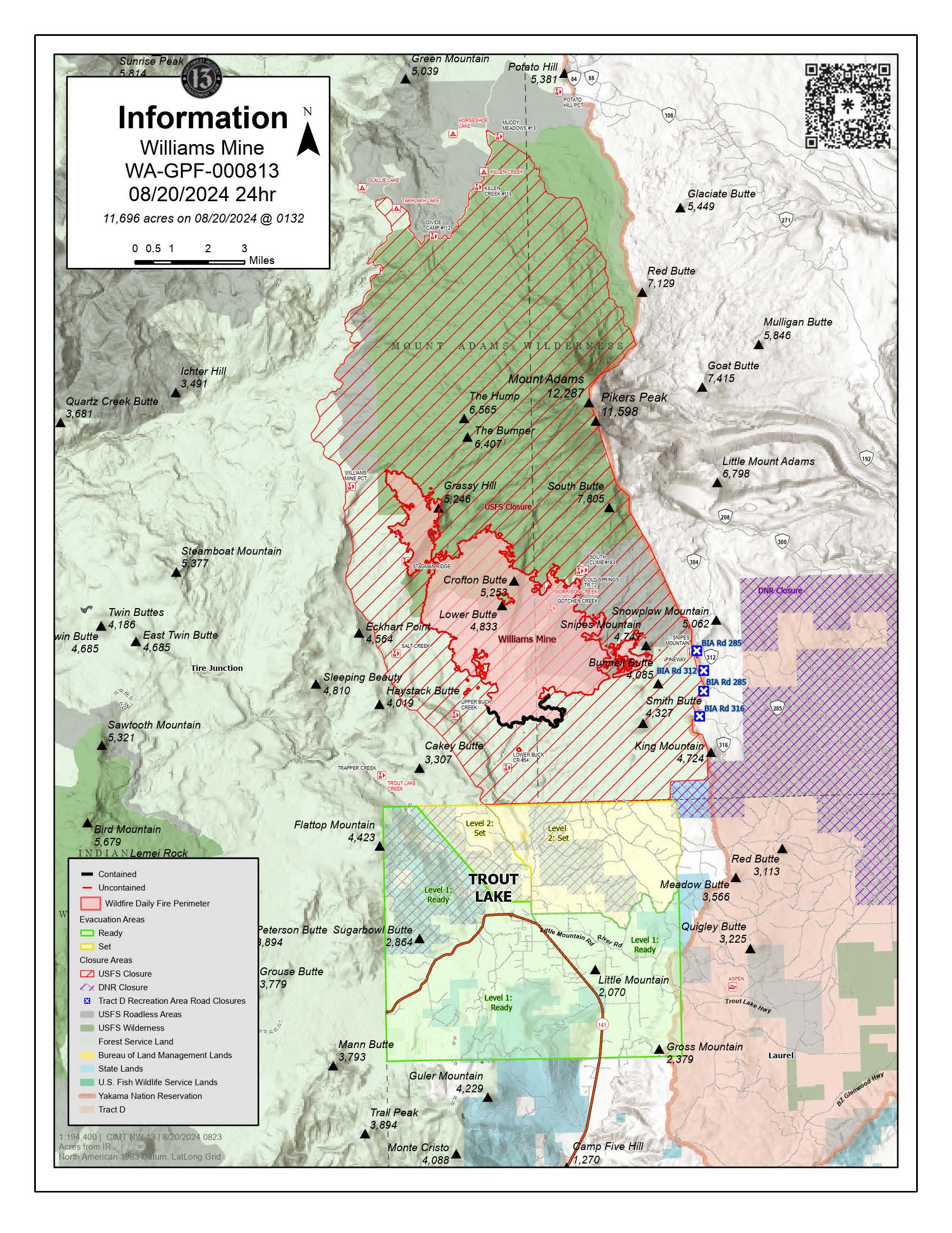
Williams Mine Fire Update 08 20 2024
Related Incident: Williams Mine Fire-GPNF
Publication Type: News
Williams Mine Fire Update for Tuesday, August 20, 2024
KEY MESSAGES:
With the rain and cooler temperatures, fire crews achieved success over the past few days in the southern and eastern areas of the fire where containment percentage has increased. The initial objectives for the Williams Mine Fire were to establish protection actions for the towns of Trout Lake and Glenwood. With perimeter containment on the southern flank of the incident, fire managers anticipate that this primary objective will be reached.
In areas where containment lines are established, crews will begin repair work on roads, dozer lines, and other areas affected by firefighting operations. Road guards remain in place as heavy equipment block roads in the closure area as they work to reduce fuel load. Road graders and other machinery are working to return access roads to Forest standards.
CURRENT STATUS:
To access all areas of the fire, crews continue to cut and remove hazard trees as well as fallen trees that are blocking accesses features because of high winds and fire damaged trees. Removal of danger trees is essential to ensure firefighters can access the fire line and have open ingress/egress routes for safe transportation. Many of the standing snags also are holding heat where firefighters continue to suppression and mop up operations to ensure there is no chance of reignition across the fire perimeter.
Most night shift resources were reallocated to bolster day shift operations as current fire behavior has diminished. Night operations have moved to a patrol status with fewer resources assigned to night operations but still will be maintaining a nightly Prescence. This will allow for continual firefighting resources being on the fire perimeter at all hours of the day and engage where necessary. These changes are possible because of the accomplishments achieved over the past few days and continuing favorable weather conditions.
WEATHER / FIRE BEHAVIOR:
The possibility of passing showers rises this afternoon, starting a trend that will increase rain chances through Thursday. Aside from the morning marine layer, clouds will gradually build through the afternoon as a weak weather system moves into the area from the west. The highest chance of showers will remain to the north of the incident. Conditions will not be conducive to active fire behavior, though there will be smoldering on the surface which may create visible smoke.
SAFETY AND CLOSURES:
Washington DNR managed lands near Trout Lake and Glenwood are closed to entry due to the Williams Mine Fire. For more information, please see http://www.dnr.wa.gov/ahtanum. The Confederated Tribes and Bands of the Yakama Nation, Tract D Recreation Area is closed, please see Yakama Tract D Road Closure for more information. Level 1 & 2 evacuations are in effect for the community of Trout Lake, and parts of Klickitat County. Evacuations are coordinated through the Klickitat County Sheriff’s Office and the Skamania County Sheriff’s Office. The FS-23 and FS-25 roads are closed, see the Williams Mine Area and Road Closure for more details. The Pacific Crest Trail (PCT) is closed from the PCT's intersection with FS 23 to Potato Hill. The current area closure spans the entire Mt. Adams Wilderness.
Battle Mountain Complex Daily Update 08 20 2024
Related Incident: Battle Mountain Complex
Publication Type: News
Type 3 organization assumes command of Battle Mountain Complex
Total Complex Estimated Acres: 183,026
Location: Ukiah, Oregon
Cause: Under Investigation
Personnel: 490
Containment: 94%
Estimated Cost: $81 million
Resources: 6 crews | 8 engines | 1 helicopter | 12 water tenders | 5 dozers
Operations: Today management of the Battle Mountain Complex is transferring to a Type 3 organization led by Incident Commander, Scott Jones at 8 p.m. The incoming fire management team will operate out of a smaller camp near Heppner. The new team is tasked with the remaining repair work and fuel removal.
This is the final update on the Battle Mountain Complex from Southwest Area Incident Management Team 3. For future information about the fire and ongoing work, please contact the Bureau of Land Management, U.S. Forest Service, or Oregon Department of Forestry.
The Southwest Incident Management Team would like to thank all the cooperating agencies, responders, and community members for their support.
For future information about the Battle Mountain Complex contact:
Bureau of Land Management
Kyle Hensley, Central Oregon Field Manager
Phone: 503-522-8844
khensley@blm.gov
Oregon Department of Forestry
Molly Johnson, NEO District PIO
Phone: 541-963-3168
Umatilla National Forest
Chris Dennis, Deputy Public Affairs Officer
Phone: 541-278-3976
Christopher.dennis2@usda.gov
There is still high fire danger in the area. Fuels remain dry, and any new fire starts have the potential for rapid growth. Firefighters assigned to the Battle Mountain Complex are ready to respond to any new fires in the area, but residents should be aware of local fire restrictions.
Burned areas have hazards like fire weakened trees that can fall over without warning. Please use caution if entering a burned area.
Weather: Variably cloudy today with highs in the upper 60s to lower 80s with minimum humidity 20-30%. Northwest winds 8-12 mph with gusts 15-25 mph in the afternoon. Mostly cloudy Tuesday evening with an isolated sprinkle or shower possible, clearing after midnight. Lows mid-40s to mid-50s with humidity 65-90%. Northwest winds 7-10 mph with gusts around 20 mph in the evening becoming light and variable overnight.
Park Fire Morning Update for August 20 08 20 2024
Related Incident: Park Fire
Publication Type: News
Park Fire Morning Update for August 20 is posted on the Park Fire Status Update Page