
Update on Clearwater Fire Monday 08 19 2024
Related Incident:
Publication Type: News
A change of command took place last night as a new incident management team took operational control of the Clearwater Fire.
Operations - Fire growth remains minimal on the Clearwater Fire, with containment increasing to 67% over the weekend. The fire will continue to burn and smolder for some time in heavy fuels and steeper terrain, expect to see more smoke this week with continued hot and dry weather. Fire managers will continue work on the Clearwater Fire and take appropriate action based on a number of factors including complexity, safety, fire behavior, and weather.
Closures - Elk Fork Campground is closed indefinitely; Clearwater Campground is closed until fire conditions allow otherwise. A road and trail closure are in effect at NFS Road #424, Elk Fork Road and NFS Trail # 760, Elk Fork Trail (021404-24-03). An area closure is also in place around the Clearwater Fire (021404-24-05) Copies of those orders can be found under “Alerts and Forest Orders” on the forest webpage or here. For safety reasons, the public is asked to respect closed campgrounds and trails. A temporary flight restriction (TFR) is in effect around the fire.
Weather | Anticipated Fire Behavior – Hot and dry conditions are expected through the week which will continue to dry out unburned areas making them receptive to fire once again.
Safety Information - The Shoshone National Forest implemented Stage 1 fire restrictions due to very dry conditions of fuels and continued hot, dry weather. Click here to view a copy of Stage 1 Fire Restrictions order (#02-14-04-24-04).
Final Daily Incident Update for Borel and SQF Lightning Fires was Sunday 08 19 2024
Related Incident: 2024 SQF Lightning
Publication Type: News
The final Daily Incident Update for the Borel and SQF Lightning Fires was on Sunday, August 18, 2024. However, other information found on this website will continue to be updated.
Final Daily Incident Update for Borel and SQF Lightning Fires was Sunday 08 19 2024
Related Incident: Borel Fire
Publication Type: News
The final Daily Incident Update for the Borel and SQF Lightning Fires was on Sunday, August 18, 2024. However, other information found on this website will continue to be updated.
Virtual Community Briefing on Wednesday August 21 at 530 pm 08 19 2024
Related Incident: Easy Fire
Publication Type: Announcement
View the live virtual community briefing on the Pioneer and Easy Fires Information Facebook Page at https://www.facebook.com/profile.php?id=61560760893080. Please submit questions in advance to 2024.pioneer@firenet.gov or via Facebook Messenger.
Virtual Community Briefing on Wednesday August 21 at 530 pm 08 19 2024
Related Incident:
Publication Type: Announcement
View the live virtual community briefing on the Pioneer and Easy Fires Information Facebook Page at https://www.facebook.com/profile.php?id=61560760893080. Please submit questions in advance to 2024.pioneer@firenet.gov or via Facebook Messenger.
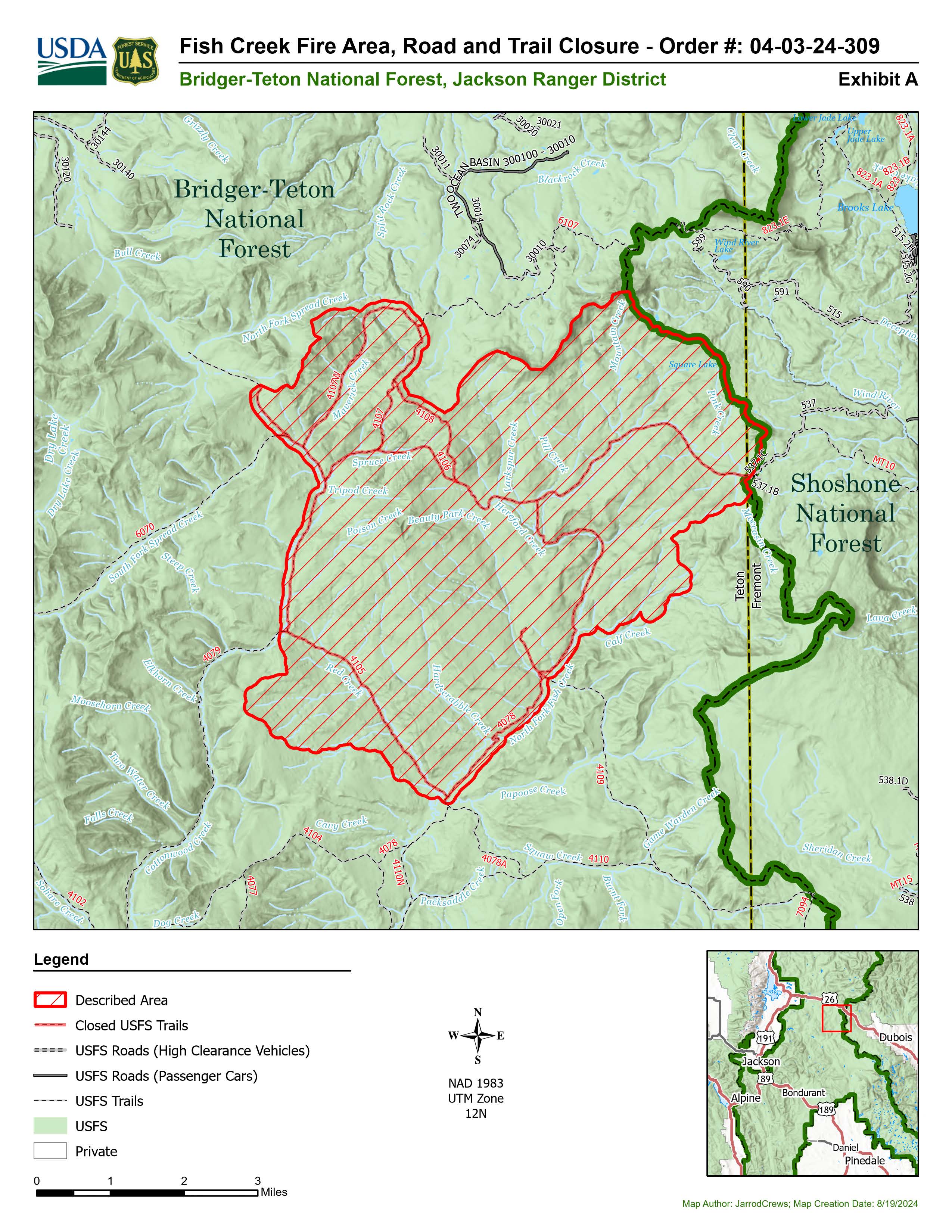
Fish Creek Fire Area Road and Trail Closure 08 19 2024
Related Incident:
Publication Type: Closures
Order Number: # 04-03-24-309
U.S. Department of Agriculture, U.S. Forest Service Bridger-Teton National Forest
Jackson Ranger District
Fish Creek Fire Area, Road, and Trail Closure
PROHIBITIONS
Pursuant to 16 U.S.C. § 551 and 36 C.F.R. § 261.50 (a) and (b), the following are prohibited on the National Forest System (NFS) area, roads, and trails in the Jackson Ranger District, Bridger-Teton National Forest, described below and shown on the attached map incorporated into this Order as Exhibit A (the “Described Area, Road, and Trails”):
1. Going into or being upon the Described Area. 36 C.F.R. § § 261.52(e)
2. Being on the Described Road. 36 C.F.R. § 261.54(e)
3. Being on the Described Trails. 36 C.F.R. § 261.55(a)
EXEMPTIONS
Pursuant to 36 C.F.R. § 261.50(e), the following persons are exempt from this Order:
1. Persons with Forest Service Permit No. FS-7700-48 (Permit for Use of Roads, Trails, or Areas Restricted by Regulation or Order), specifically exempting them from this Order or a written determination by a Forest Service authorized officer that a permit is not required under 36 C.F.R. § 251.50(e)(1) or (2); and.
2. Any Federal, State, or Local Officer, or member of an organized rescue or firefighting force in the performance of an official duty.
Order Number: # 04-03-24-309
DESCRIBED AREA/ROADS/TRAILS
The Described Area includes all NFS lands within the following boundaries: Starting at the northern flank of Two Ocean Mountain heading SE along the Continental Divide to its intersection with Forest Service Road (FSR) 30750 (Moccasin Basin) following and including said road southwesterly to FSR 30800 northerly along said road to its intersection with Cottonwood Creek Trail 4079, following said trail northerly to the Cottonwood/South Fork Spread Creek Divide, then easterly along said divide following the Two Ocean Basin/Maverick Creek/Hereford Creek/Mountain Creek Divide back to its point of origin at the northern flank of Two Ocean Mountain.
The Described Roads and Trails include the following NFS roads and trails located within and bordering the Described Area:
1. Portion of NFS Road 30750 (Moccasin Basin Road), to its intersection with Forest Road 30800. Forest Road 30800 in its entirety.
2. Portions of NFS Trail 4079 (Cottonwood Creek Trail), Trail 4106 (Spruce Creek Trail), Trail 4078 (Moccasin Basin Trail), and Red Creek Trail 4105.
PURPOSE
The purpose of this Order is to protect public safety during the Fish Creek Fire.
IMPLEMENTATION
1. This Order shall be in effect from August 18, 2024, at 12:00 P.M. through September 30, 2024 at 6:00 A.M., unless rescinded.
2. A map identifying the Described Area/Roads/Trails is attached and made part of this Order as Exhibit A. For a digital version of this Order and Exhibit A, go to https://www.fs.usda.gov/alerts/btnf/alerts-notices
3. Unless otherwise expressly defined in this Order, the terms used in this Order are defined by the regulations of the Secretary of Agriculture, 36 C.F.R. Chapter II, Parts 200-299. If there are terms in this Order that are not expressly defined in the Order or 36 C.F.R. Chapter II, Parts 200-299, their meaning shall be determined by their plain language definitions.
4. A violation of the above prohibitions is punishable as a Class B misdemeanor by a fine of not more than $5,000 for individuals and $10,000 for organizations, or by imprisonment for not more than six months, or both. 16 U.S.C. § 551; 18 U.S.C. §§ 3559, 3571, and 3581. Order Number: # 04-03-24-309
5. Contact the Jackson Ranger District in Jackson, WY, (307) 739-5400, and Bridger-Teton National Forest Supervisor’s Office in Jackson, WY, (307) 739- 5500, for more information about this Order.
6. This Order supersedes any previous Orders prohibiting the same or similar acts in the same Described Area.
Signed and issued on August 18, 2024.
___________________________
(for) CHAD E. HUDSON
Forest Supervisor
Bridger-Teton National Forest
2620 Road Fire Update 08 19 2024
Related Incident: 2620 Road Fire
Publication Type: News
2620 Road Fire
Incident Commander: Kent Stanford/Blair Joiner
Fire Information Phone Number: 360-323-1903
Email: 2024.2620Road@firenet.gov
Facebook: www.facebook.com/2620RoadFire2024
InciWeb: https://inciweb.wildfire.gov/incident-information/waolc-2620-road-fire
Update as of: August 19, 2024
Estimated size: 398 acres
Containment: 8%
Start Date/Time: 8/14/2024 at 5:00 PM
Area of Origin: West of Brinnon, North of Duckabush Rd. on Mt. Jupiter
Cause: Undetermined
Structures Damaged: None
Update: Afternoon and evening storms brought gusty winds and 0.1” to 0.3” of rain in scattered areas across the fire, but the entire fire did not receive rain. Weather conditions, steep terrain, and poor road conditions slowed fire line progression, but crews continued to work hard and pushed forward with line construction. Firefighters will continue to assess existing fire breaks, adjust tactics, and additional resources are expected to arrive over the next few days. There is a Temporary Flight Restriction (TFR) in place over the fire. If you fly, we can’t.
Residents are asked to continue to use caution, be aware of fire vehicles that may require longer stopping distance, and to please stay out of the fire area while crews continue fire suppression efforts. Firefighter and public safety remains our number one priority.
The percentage of containment can sometimes be a confusing term. A fire is considered contained when a control line has been established around the fire, and the fire is not expected to spread. Fireline supervisors evaluate these control lines daily to determine the percentage of actual fire containment based off of current and expected fire behavior. Keep in mind that percentages can increase or decrease, during the life of a fire, depending on fire activity.
Weather: Today’s weather remains hazy in the morning with clearing during the day. Evening weather brings the chance of scattered storms with minimal rain accumulation.
Road Closures: Duckabush Road and Mt. Jupiter Road (2620 Road) remain closed except for residents on these roads.
Forest Closures: Olympic National Forest has updated closures are located at www.fs.usda.gov and Olympic National Forest – Alert and Closures web page
Evacuation Levels/Shelters: The 2500 block and above of Duckabush Road remains at a Level 2. The 1000 block up to the 2500 block of Duckabush Road remains at a Level 1. There are no shelters open at this time.
Flat Fire Area Road and Trail Closure OrderNumber040203122 08 19 2024
Related Incident:
Publication Type: Closures
Order Number: # 0402-03-122
U.S. Department of Agriculture, U.S. Forest Service
Boise National Forest
Idaho City Ranger District
Flat Fire Area, Road, and Trail Closure
PROHIBITIONS
Pursuant to 16 U.S.C. § 551 and 36 C.F.R. § 261.50 (a) and (b), the following are prohibited on the National Forest System (NFS) lands, roads, trails in the Boise National Forest Area(s) described below and shown on the attached map incorporated into this Order as Exhibit A (the “Described Area, Roads, and Trails”):
- Going into or being upon the Described Area. 36 C.F.R. § 261.52(e).
- Being on the Described Roads. 36 C.F.R. § 261.54(e).
- Being on the Described Trails. 36 C.F.R. § 261.55(a).
EXEMPTIONS
Pursuant to 36 C.F.R. § 261.50(e), the following persons are exempt from this Order:
- Persons with Forest Service Permit No. FS-7700-48 (Permit for Use of Roads, Trails, or Areas Restricted by Regulation or Order), specifically exempting them from this Order or a written determination by a Forest Service authorized officer that a permit is not required under 36 C.F.R. § 251.50(e)(1) or (2).
- Any Federal, State, or local officer, or member of an organized rescue or fire fighting force in the performance of an official duty.
- Federal or State administrative personnel in the performance of an official duty.
DESCRIBED AREA, ROADS, AND TRAILS
The Described Area is all NFS Lands within the following boundaries:
- Beginning where NFS Road #379 intersects with the Boise National Forest Boundary near the northwest corner of Section 31, Township 7 North, Range 6 East.
- Following NFS Road #379 to the intersection with NFS Road #379A in Section 30, T7N, R6E.
- Following NFS Road # 379A to the junction with northern boundary of Section 30 where it continues west along Section 30, 29, and 28, T7N, R6E to the intersection of NFS Road #314 in Section 21, T7N, R6E.
- Following NFS Road #314 but excluding NFS Road #314 which remains open to the intersection with NFS Road #380B in Section 11, T7N, R6E.
- Following NFS Road #380B but excluding NFS #380B which remains open to the intersection with NFS Road #380 in the southeast corner of Section 23, T8N, R6E.
- Following NFS #380 but excluding NFS Road #380 which remain open to the intersection with NFS Road #397 in the southwest corner of Section 23, T8N, R6E.
- Following NFS #397 but excluding NFS Road #397 which remains open to the intersection with Forest Road #382 in the northeast corner of Section 22, T8N, R5E.
- Following Forest Road #382 which remains open to the public to the intersection with the Forest Boundary in Section 26, T8N, R5E.
- Following the Forest Boundary easternly and southernly back to the beginning point of the intersection of #379A in Section 31, T7N, R6E.
The Described Roads include:
- The portion of NFS Road #380 outside of the Described Area starting at the Section boundary of Section 3, Township 7N, Range 5E and Section 10, Township 7N, Range 5E; continuing in Sections 2 and 3 Township 7N, Range 5E and through Sections 35 and 36 Township 8N, Range 5E and into the Described Area.
- All NFS Roads within the Described Area: NFS Roads #319, #319F, #319F3, #379, #379A, #379B, #380, #380B1, #380E, #380F, #380G, #380H, #382, #382C, #382C3, #382C4, #382C5, #382D, #382D1, #397B, #397E, and #397F.
The following NFS Roads bordering the Described Area are open: NFS Road #397, #314, and #380B1.
The Described Trails are all NFS Trails within the Described Area: NFS Trails # #163, #169, #170, and #690.
PURPOSE
The purpose of this Order is to protect public safety during the Flat Fire.
IMPLEMENTATION
- This Order shall be in effect from August 15, 2024 at 06:00 AM through December 31, 2024, at 11:59 PM, unless rescinded.
- A map identifying the Described Area, Roads, and Trails is attached and made part of this Order as Exhibit A. For a digital version of this Order and Exhibit A, go to https://www.fs.usda.gov/alerts/Boise/alerts-notices.
- Unless otherwise expressly defined in this Order, the terms used in this Order are defined by the regulations of the Secretary of Agriculture, 36 C.F.R. Chapter II, Parts 200-299. If there are terms in this Order that are not expressly defined in the Order or 36 C.F.R. Chapter II, Parts 200-299, their meaning shall be determined by their plain language definitions.
- A violation of the above prohibitions is punishable as a Class B misdemeanor by a fine of not more than $5,000 for individuals and $10,000 for organizations, or by imprisonment for not more than six months, or both. 16 U.S.C. § 551; 18 U.S.C.
§§ 3559, 3571, and 3581.
- Contact the Idaho City Ranger District in Idaho City, ID at (208) 392-6681, and Boise National Forest Supervisor’s Office in Boise, ID, at (208) 373-4100, for more information about this Order.
- This Order supersedes Order #0402-03-121 and any previous Orders prohibiting the same or similar acts in or on the same Described Area, Road, or Trail.
Signed and issued on 8/14/2024.
Brant Petersen
Forest Supervisor
Boise National Forest
Flat Fire Daily Update 08 19 2024
Related Incident:
Publication Type: News
Flat Fire Update
August 19, 2024
Email: 2024.flat@firenet.gov
Incident Information Phone Line: 208-923-1265 – daily 8 a.m. to 8 p.m.
Flat Fire Facebook: https://www.facebook.com/IdahoDepartmentofLands
InciWeb: https://inciweb.wildfire.gov/incident-information/idids-2024-flat
Smoke Report: https://www.airnow.gov
Flat Fire Facts
Location: Approx. 1-mile northeast of Pioneerville in Boise County, Idaho
Reported: August 5, 2024
Cause: Lightning/Natural
Acres: 3,585
Containment: 14%
Personnel: 332 (10 hand crews, 10 engines, 4 water tenders, 3 dozers, 1 masticator and 4 helicopters)
Fuels: Timber with grass and understory
Highlights:
The Great Basin Complex Incident Management Team 6, led by Incident Commander Mack McFarland, assumed command of the Flat Fire at 6:00 a.m., August 19, 2024. The Complex Incident Management Team brings additional resources and management capabilities to implement a full suppression strategy for the Flat Fire. The Flat Fire was first detected August 5 after a thunderstorm moved through the area.
The fire has seen moderate activity with minimal growth. Minimal torching and spread from downhill rolling of burning materials is expected today. Crews have begun mop-up of the north and west sides of the fire. On the east side of the fire, crews continue constructing dozer line and cleaning up snags.
Crews are continuing work building lines to contain fire growth on the fire’s southern edge in order to prevent the fire from establishing itself in the Elk Creek drainage.
Flat Fire Community Meeting: The meeting will be at 6:00 p.m. Monday, August 19 at the Ray Robison Community Hall in Idaho City. Fire personnel will provide the latest update on Flat Fire activity.
Fire Behavior & Weather: Cooler weather is expected this week with 20-25 percent humidity levels in the fire area. Winds are expected to continue from the south at 6-10 mph. Gusts up to 20 mph are possible which could lead to increased fire activity.
Road and Trail Closures and Restrictions:
The Boise National Forest has implemented an Area Closure for the Flat Fire. See link for additional information: https://www.fs.usda.gov/alerts/boise/alerts-notices
The Summit Flat Road (#380) between Pioneerville and Coulter Summit is also closed for public and firefighter safety.
Middle Fork Complex Wapiti Bull Trout Daily Update Sunday 08 18 2024
Related Incident:
Publication Type: News
Incident Commander: Rick Connell, Northern Rockies Team 5
Middle Fork Complex Location: 9 miles east of Garden Valley, ID
Bull Trout Location: 15 miles WNW of Stanley, ID Wapiti Location: 2 miles southwest of Grandjean, ID
Start Dates: 07/24/24 – 08/06/2024
Cause: Lightning
Size:
Bull Trout: 271 acres Wapiti: 4,943 acres
Middle Fork Complex: Bulldog: 4,392 acres Nellie:11,237 acres
Containment: Middle Fork Complex: 5% Wapiti: 10% Bull Trout: 92%
Resources on site:
Middle Fork Complex: 2 hotshot crews; 5 type 2 hand crews; 9 engines; 1 bulldozer; 2 water tenders;
1 skidgen
Wapiti: 1 type 2 hand crew; 8 engines; 1 water tender
Bull Trout: 2 engines
Total Personnel: Middle Fork Complex: 342 Wapiti: 82 Bull Trout: 22
KEY MESSAGE:
Yesterday a red flag warning was in effect for hot, dry and unstable conditions across the area. Most fires in the area saw increased activity and growth as a result of the hot, dry, windy conditions. Fires were active late into the night. On the Wapiti Fire, due to the increased fire behavior, some structures near the Wapiti Summer Home area were impacted. Firefighters are currently assessing the impacts to these structures.
Join us for a Middle Fork Complex, Bull Trout, and Wapiti Fire Community Meeting today, August 18, 2024, at 7pm for an in-person explanation of current fire activity and planned actions on these fires. The Community Meeting will be located at the Crouch Community Center, 1022 Old Crouch Road.
CURRENT STATUS/PLANNED ACTIONS:
Middle Fork Complex: The Middle Fork Complex is comprised of the Bulldog and Nellie fires.
Yesterday the Bulldog Fire grew over 680 acres to the north and east due to southwest winds. The south/southwest line held and continued to be maintained and improved throughout the day. Today crews will continue along the ridge line to the north holding and improving the previously built fire line. The fire is expected to grow to the north/ northeast with weather conditions today. The public is reminded that the Middlefork Road (FS Road 698) is closed at the Forest Service boundary just north of Lightning Creek and the Scriver Creek Road (FS Road 693) is also closed at the Forest Service Boundary for firefighter and public safety as crews continue to work to protect private property and structures in the vicinity of Crouch.
The Nellie Fire experienced increased fire activity yesterday and burned into the night growing over 4,000 acres to the north and west. Firefighters will continue point protection at lookouts and a communication tower. Air resources continue to support the fire by cooling the fire’s edge. Smoke will remain visible as weather conditions remain hot and dry. The public is reminded that Forest Service Road #555 is closed at the intersection of Highway 17 all the way to the Forest Service Road #579 intersection.
Wapiti Fire: Yesterday, the Wapiti Fire experienced active fire behavior and spotting due to the red flag conditions, terrain and shifting winds. The fire spotted into the 2018 Wapiti fire area and firefighters and helicopters responded to the increased activity. Some structures within the Wapati Summer Home area were impacted by the fire. Today, firefighters are assessing the impacts from the fire and more information will be made available when available.
Bull Trout Fire: The Bull Trout fire is still 92% contained, with little heat observed yesterday. Due to falling dead and live trees, crews cannot safely access the interior of the fire and will continue to patrol the perimeter.
WEATHER AND FIRE BEHAVIOR:
Yesterday a red flag warning was in effect through the evening for hot, dry and unstable conditions across the area. Overnight conditions allowed for continued fire activity until after midnight, with light downslope, down valley winds. Today, critical fire weather conditions continue however a Red Flag Warning has not been issued. The morning inversion will lift early this afternoon allowing relative humidity values to drop for the remainder of the day. Winds will remain terrain driven, across most sheltered areas with southwest winds across the fire area. Backing, group tree torching, and long-range spotting with wind and terrain influenced movement is expected today.
CLOSURES, RESTRICTIONS, AND EVACUATIONS:
Middle Fork Complex: The Boise County Sheriff's Office continues to maintain the Level 2 evacuation notice for residents on and near the Middlefork Road between Stump Ranch Road up to Tie Creek Campground. The Boise National Forest issued an area closure for the fire (Closure #0402-06-59) effective August 12, 2024. The purpose of this order is to protect public safety during the fires.
Wapiti Fire: The evacuation order for Summer Homes and the Sawtooth Lodge remain in effect for the Wapiti Fire, as does the area closure issued by the Sawtooth and Boise National Forests (Closure #0402-05-94) effective August 12, 2024. This Order is for public and firefighter safety during fire suppression efforts of the Wapiti Fire.
Bull Trout Fire: The Bull Trout Fire Area Closure (Closure #0402-05-93) remains in effect for the roads and trails within the perimeter of the fire. The Boise National Forest issued this order on August,12, 2024. It will be rescinded as soon as it is safe to do so.
Closure information and maps are posted on the Forest’s website and the fire’s Inciweb page as they are in place. https://tinyurl.com/2u8v3pf7
The Boise National Forest, Idaho Department of Lands, and Bureau of Land Management are in Stage 1 fire restrictions on state, endowment, private and federal lands within the West Central Mountains Fire Restrictions Zone. For more information on the restrictions and a map visit:
https://www.idl.idaho.gov/fire-management/fire-restrictions-finder/