
Ratio Mountain Area Closure 08 22 2024
Related Incident: Ratio Mountain
Publication Type: Closures
The Forest has issued an area closure around the fire area, north of Whitehall on the Butte Ranger District. An area closure often involves specific trail and road sections. The area closure information and maps can be found on the Forest website, under the Closures and Alerts tab.
PROHIBITIONS
Pursuant to 16 U.S.C. § 551 and 36 C.F.R. § 261.50(a), the following are prohibited on the National Forest System (NFS) lands in the Butte Ranger District, Beaverhead-Deerlodge National Forest, described below and shown on the attached map incorporated into this Order as Exhibit A (the “Described Area”):
1. To go into or be upon any area which is closed for the protection of public health and safety 36 C.F.R. § 261.53 (e).
EXEMPTIONS
Pursuant to 36 C.F.R. § 261.50(e), the following persons are exempt from this Order:
1. Owners or lessees of land in the area.
2. Residents in the area.
3. Persons with Forest Service Permit No. FS-7700-48 (Permit for Use of Roads, Trails, or Areas Restricted by Regulation or Order), specifically exempting them from this Order or a written determination by a Forest Service authorized officer that a permit is not required under 36 C.F.R. § 251.50(e)(1) or (2).
4. Any Federal, State, or Local Officer, or member of an organized rescue or firefighting resource in the performance of an official duty.
DESCRIBED AREA
This closure applies to the following National Forest System (NFS) lands, approximately 15 miles north of Whitehall, MT.
1. Area Closure. All of the National Forest System lands within:
• T3N, R5W, SECTIONS 1, 2, 3
• T4N, R5W SECTION 35
PURPOSE
The purpose of this Order is for public safety due to wildfire and active fire suppression activities.
IMPLEMENTATION
1. This Order shall be in effect from 12:01 a.m. on August 22, 2024 through October 15, 2024, unless rescinded.
2. A map identifying the Described Area/Roads/Trails is attached and made part of this Order as Exhibit A. For a digital version of this Order Exhibit A, go to Beaverhead-Deerlodge National Forest - Alerts & Closures (usda.gov)
3. Unless otherwise expressly defined in this Order, the terms used in this Order are defined by the regulations of the Secretary of Agriculture, 36 C.F.R. Chapter II, Parts 200-299. If there are terms in this Order that are not expressly defined in the Order or 36 C.F.R. Chapter II, Parts 200-299, their meaning shall be determined by their plain language definitions.
4. A violation of the above prohibitions is punishable as a Class B misdemeanor by a fine of not more than $5,000 for individuals and $10,000 for organizations, or by imprisonment for not more than six months, or both. 16 U.S.C. § 551; 18 U.S.C. §§ 3559, 3571, and 3581.
5. Contact the Butte Ranger District in Butte, MT, (406) 494-2147, and Beaverhead-Deerlodge National Forest Supervisor's Office in Dillon, MT, (406) 683-3900, for more information about this Order.
6. This Order supersedes any previous Orders prohibiting the same or similar acts in the same Described Area/Roads/Trails.
Ruby Fire Update and Map August 23 2024 08 23 2024
Related Incident: Ruby Fire
Publication Type: News
Ruby Fire Quick Facts
Size: 955 acres Location: North Cascades National Park, Ruby Mountain, Diablo, Washington
Containment: 0% Cause: Lightning/Natural
Start Date: August 9, 2024 Total Personnel: 85
Fire Information:
Inciweb: https://inciweb.wildfire.gov/incident-information/wancp-ruby-fire Email: 2024.Ruby@firenet.gov
Facebook: https://www.facebook.com/people/Ruby-Fire/61563760546137
Phone: 1-360-208-8096
Current Status: Fire suppression efforts continue today as safety permits; access is difficult due to steep terrain and hazards. Yesterday, firefighters hiked the Pyramid Trail and Thunder Knob to access point protection areas, identify equipment needs, and suppression strategies. Smoke from the Ruby Fire remains noticeable from public areas. An 11-person Wildland Fire Use module from Yosemite NP has been assigned to the Ruby Fire.
Planned Actions: Firefighters will continue to protect critical infrastructure, park campgrounds, trails, backcountry camps, and other resources in preparation for possible fire growth. The Ruby Fire is a full suppression fire, and firefighters are utilizing strategies and tactics that provide the highest likelihood for success, while mitigating risks to firefighters and the public. Main objectives are protecting human life, minimizing damage to values at risk, and limiting wildfire spread to the north and west.
Weather: Friday, cloudy early with rain showers turning to steady rain in the evening, 90% chance for rain and a 25% chance for thunderstorms in the afternoon. Highs near 71. West winds 3 to 6 mph gusting to 10 mph. Friday evening and night cloudy with a 100% chance for rain. Lows near 53. Rain showers will continue through Saturday. Stream and creeks may run high due to rainfall. Rockfall may occur from rainfall.
Closures: There are multiple closures in place for public safety. Colonial Creek South Campground and boat launch, Thunder Arm south of Diablo Lake. SR20 North Cascades Highway reopened yesterday from Granite Creek and Easy Pass trail post (mileposts 148-157). For a full list of closures visit https://go.nps.gov/fireclosures and monitor Washington DOT real time map for up-to-date information.
Burning Restrictions: Campfires, the ignition of wood, briquettes, or any fuel in fire pits, fire pans and barbeque grills, are banned in all portions of North Cascades National Park Service Complex: North Cascades National Park, Ross Lake National Recreation Area, and Lake Chelan National Recreation Area.
Drone Restrictions: Drones can seriously impact the safety of firefighting efforts, and operating drones within North Cascades National Park is prohibited, except with prior written approval from the superintendent.
Cooperating Agencies & Tribes: National Park Service, Upper Skagit Indian Tribe, Seattle City Light, Whatcom County, Whatcom County Sheriff’s Office, Washington State Dept. of Transportation.
Smoke: U.S. Interagency Wildland Fire Air Quality Response Program - Overall air quality will be GOOD today in upper Skagit Valley. https://outlooks.wildlandfiresmoke.net/outlook/f79a6d6d, https://www.airnow.gov/
If you would like to sign up for our daily updates, please send an email to: 2024.Ruby@firenet.gov
Boise Fire Update August 23 202408 23 2024
Related Incident: 2024 Boise Fire
Publication Type: News
Headlines
- A public meeting will be held at Forks of Salmon Community Club on Saturday, August 24 at 5 p.m.
- California Team 11 (Fogle) has arrived to the Boise Fire and will be shadowing with California Team 10 today and tomorrow. California Team 11 will take command of the fire on Sunday, August 26, at 7 a.m.
- Traffic control is in place along the Salmon River Road between Butler Flat and Nordheimer Flat for the safety of firefighters and residents. Expect up to 30-minute delays.
- Fire information phone: (707) 572-4860 or email at 2024.Boise@firenet.gov
- Get all your Boise Fire information in one mobile-friendly place! https://linktr.ee/2024boisefiresrf
- Evacuations are in place for the Boise Fire for residents near the fire area in Humboldt County. For the most current evacuation information please visit the Boise Fire linktree or visit--
- Humboldt County: https://humboldtgov.org/356/Office-of-Emergency-Services
- Siskiyou County: https://www.co.siskiyou.ca.us/emergencyservices
Leader’s Intent: The Boise Fire is being managed with a full suppression strategy.
Operational Update: Yesterday, fire activity moderated due to cooler weather and cloud cover. Firefighters worked on mopping up and patrolling the north and west edges of the fire. Crews are nearing the completion of constructing indirect line from Nordheimer Flat to Mullins Camp. Line construction along the southern portion of the fire is expected to take one more day of work. Crews continue to prepare and plan for structure protection.
Incoming wetting rain may cause challenges or delays in accessing the fire area, and crews in many areas will be assessing their ability to work today as they go. However, crews will remain assigned to the Boise Fire as there is still a considerable amount of uncontained fire edge within indirect lines. With warm, dry conditions ahead, fire managers will be monitoring carefully for activity as vegetation is expected to return quickly to critically dry levels.
Weather and Fire Behavior: Wetting rain is expected over the fire area today and tomorrow, with notably colder temperatures. This system is expected to pass out of the area by the end of the weekend with a return to much more seasonable conditions on Monday.
Settings - change map background and toggle additional layers
Filter - control incident types displayed on map.
Zoom to your location
Reset map zoom and position
Could not determine your location.
Show Legend
 Wildfire
 Prescribed Fire
 Burned Area
Response
Burned Area
Response Other
Other
Ratio Mountain
Unit Information
Incident Contacts
Homestead Complex Fire Update Friday 08 23 2024
Related Incident:
Publication Type: News
Homestead Complex Fire Update for Friday, August 23, 2024
No Man, Salmon 33, Horse Heaven Creek, Bullpup, Fuller Lake, Reynold’s Butte, Lost Bucket
Start date: July 19, 2024 | Location: Northeast of Glide, Oregon | Total Personnel: 1040
Total Homestead Complex Fire size: 5,898 acres | Cause: Lightning | Containment: 38%
Summary
Fire activity on the Homestead Complex was limited to smoldering and creeping with slow rates of spread on Thursday. Last night an accumulation of 0.50 inches of rain was received which will make fire growth less active for today’s operational period, seeing rates of spread reduced to limited surface activity of a few inches a minute in areas.
No Man (2,080 acres) and Salmon 33 (261 ac.): On Thursday, fire crews secured more containment on the northwest side of the No Man Fire and on the northeast side of the Salmon 33 fire. They will continue to patrol and secure direct control lines. Also, efforts are underway to improve control lines and protect the Chilcoot communication site and associated infrastructure on the No Man Fire. Crews will patrol and mop up to secure the fire edge on the Salmon 33 Fire.
Horse Heaven Creek Fire (2,295 ac.): Crews constructed direct lines on the south edge of the fire and developed plans to build a fire line on the northwest side from Horse Heaven Creek to Ridge Road.
Bullpup Fire (476 ac.) and Fuller Lake Fire (418 ac.): Firefighters will work to contain the fire within the control lines along 5850 and 300 roads as conditions allow. They will also continue prepping alternate control lines with heavy equipment, fallers, and crews. Fire managers have requested a hot shot hand crew as a surge force to construct line on the northside of the Bullpup Fire.
Reynolds Butte Fire (334 ac): 100% contained on August 22, 2024.
Lost Bucket Fire (34 ac.): 100% contained on July 29, 2024.
Weather: Today there is a chance of thunderstorms with variable conditions for the next few days. Also, today there is a possibility of lightning and hail. Temperatures will be in the mid-60s.
Closures and Fire Restrictions
The Bureau of Land Management (BLM), Roseburg District, has issued a closure order for portions of BLM land which border the Umpqua National Forest Emergency Fire Closure north of Steamboat. The closure order can be viewed here: https://www.blm.gov/sites/default/files/docs/2024-07/orwa-fpo-rbg-072624.pdf.
The Umpqua National Forest has Emergency Fire Closures in place impacting every district of the forest. https://www.fs.usda.gov/alerts/umpqua/alerts-notices.
There is a Temporary Flight Restriction (TFR) over the Homestead Complex Fire. Please remember, if you fly we can’t! If a drone or other aircraft enters the air space, all firefighting aviation equipment will be grounded.
Please scan the QR code below for more Homestead Complex Fire information, social media links, and resources.
Fire Information Line: 541-208-7100 (Staffed 8 a.m. to 8 p.m.)
West Mountain Complex Daily Update 08 23 2024
Related Incident: Dollar Fire Wolf Creek FireBoulder Fire
Publication Type: News
The West Mountain Complex includes five fires- Boulder, Snag, Wolf Creek, Dollar, and Goat Fires. Read our daily update for more information. Scroll to the bottom of the page for PDF versions of the daily update, the daily map, and the daily smoke report.
QUICK FACTS
Fire | Location | Size | Containment | Start Date
Boulder | 9 miles SW of Cascade | 2,313 acres | 44% | 7/24/2024
Wolf Creek | 5 miles W of Donnelly | 1,154 acres | 95% | 7/24/2024
Snag | 11 miles E of Cascade | 25,235 acres | 3% | 8/5/2024
Dollar | 18 miles NE of Cascade | 2,665 acres | 0% | 8/5/2024
Goat | 11 miles SE of Cascade | 1,963 acres | 0% | 8/5/2024
Cause: Lightning (All Fires)
Total Incident Personnel: 1,068
Army firefighting Soldiers from the 14th Brigade Engineer Battalion, based at Joint Base Lewis-McChord in Washington continue to assist with suppression repair of the dozer and fireline along the Wolf Creek Fire. Additionally, they are integrated with wildland fire crews to conduct indirect suppression tactics as well as support efforts to secure, hold, and maintain fire control lines within the West Mountain Complex.
Weather | Anticipated Fire Behavior:
Windy conditions persisted throughout the day and evening with heavy smoke from the Middle Fork Complex affecting the area. The Red Flag conditions included very low relative humidity ranging from 10 to 22 percent, and winds up to 25 mile per hour. Winds from the south southeast pushed smoke and fire activity towards the northwest. Today weather conditions will de-escalate to Watch Out conditions as the humidity increases and winds die down. The long-term forecast shows a possibility of up to 1/10th of an inch of rain with colder temperatures for the weekend.
Boulder Fire: https://tinyurl.com/ycdfv3tv
Firefighting Crews used direct suppression tactics to secure, hold, and cool down spot fires along the southern perimeter of the fire yesterday. They also continued to secure and increase the depth of fuels reduction efforts along portions on the northern edge of the fire. The interior of the fire containing large logs will continue to smolder and produce smoke for days to come. Today, crews will work to continue to hold containment lines and monitor fire activity along the fire’s perimeter.
Dollar Fire: https://tinyurl.com/bef6r3tz
The northern reaches of the Dollar Fire continued to progress towards the boundary of the Payette National Forest on Thursday. Rock screes to the west helped to slow down fire growth westward. Engines and Army Crews patrolled these boundaries for hot spots. Firefighters also installed hose lays along the southwestern side of the fire. Firefighters will continue to prepare contingency lines on the western edge to prepare for future firing operations intended to reduce burnable vegetation.
Snag Fire: https://tinyurl.com/4k9dk3mu
Firefighters used direct suppression tactics and aerial resources to address new spot fires on the southern edge of the Snag Fire. Active fire also persisted north of the Warm Lake Highway as it moved towards the previously burned landscape of the Cascade Complex to the north. Crews will continue to look for opportunities to use firing operations to enhance and secure control lines to prevent movement and impacts to the Clear Creek drainage to the west. Chippers and masticators (large log demolition equipment) enhanced the progress of fireline construction on the southern boundary of contingency lines. Today crews will continue to check for spot fires and interior heat while patrolling control lines and mopping up the fire’s edge.
The Valley County Sheriff’s Office is allowing residents and vetted contractors (those who provide services to residents in Warm Lake, Yellow Pine, and Big Creek areas) to enter along the Warm Lake Highway without an escort. The access is dependent on weather and fire activity. The Warm Lake Highway remains closed to the public and will only be open to those approved in advance by the Sheriff’s Office. For more information visit: https://tinyurl.com/mtartvas
Wolf Creek Fire: https://tinyurl.com/mcksrfvh
Firefighters located and secured a single torching tree interior of the perimeter of the northern corner of the fire. Crews continued to enhance rehabilitation efforts along the dozer and handlines along the Weiser Creek drainage. Rehabilitation, and mop up work will continue again today.
Goat Fire: https://tinyurl.com/2h4a3dvr
Smoke from the Middle Fork Complex to the south suppressed fire behavior on the Goat Fire yesterday. The northeast edge of the fire continues to slowly move towards the previously burned fuels of the Cascade Complex. Crews will continue to improve and enhance dozer line on the western side of the fire to create a fuel break to improve contingency lines.
Other fire information:
Middle Fork Complex (Nellie, Anderson, and Bulldog Fire): https://tinyurl.com/3rhawr5y
Wapiti Fire: https://tinyurl.com/yf7reydj
Bulltrout Fire: https://tinyurl.com/tatwwk5t
SNAG FIRE EVACUATION INFORMATION
The Valley County Sheriff’s Office issued a “ready” evacuation order for Warm Lake residents and the North Shore Lodge at Warm Lake on August 7. The map can be found on Inciweb: https://tinyurl.com/42auxnk8. A second “ready” evacuation order was issued on August 8 for the Horsethief area, including the YMCA Camp, and areas of Scott Valley. This map can also be found on Inciweb, with the relevant areas outlined in purple: https://tinyurl.com/4vfj657x
Review the READY, SET, GO evacuation procedure for Valley County: https://www.co.valley.id.us/ReadySetGo
For timely information on evacuations, check out your county’s emergency alert system.
- Valley County: https://www.co.valley.id.us/CompleteEmergencyNotificationandAlerting
- Adams County: https://public.alertsense.com/SignUp/PublicUser.aspx?regionid=1077
ROAD CLOSURES
Warm Lake Highway Closure: The Valley County Sheriff’s Office has closed Warm Lake Highway due to the Snag Fire. The Warm Lake Highway is closed at the Horsethief Road intersection east toward Warm Lake and from the Johnson Creek Road intersection west toward Warm Lake. Scott Valley residents will be allowed access. For updates on county closures visit: https://www.co.valley.id.us/departments/SheriffsOffice.
FOREST CLOSURES
Hunting Closures: Prior to entering the backcountry, Idaho Fish and Game advises hunters to check with their local Forest Service ranger district offices or county sheriffs’ offices for fire closures in their hunt areas. For more information visit: https://tinyurl.com/4td8hwzc
The Boise National Forest modified or expanded their wildfire closures on August 12, 2024, to address public and firefighter safety and respond to increased wildfire growth. This closure area begins at the south end of the Dollar/Oro (Snag) fire closure area and continues south to Crouch and the Banks-Lowman Hwy, and east to the 579, 563 and 582 roads.
Wolf Creek Fire Closures: On the Payette National Forest, a closure includes popular National Forest System roads around the Wolf Creek fire such as: sections of NFS Road #1763 (West Mountain Jeep Trail), #835, #206, and #326. On the Boise National Forest, Forest Road #435 (Anderson Lake Road) was closed on August 1.
Boulder Fire Closures: The Boise National Forest has issued a closure order #0402-04-98 for National Forest System (NFS) roads, trails and lands encompassing the Boulder Fire. The closure was enacted to protect public safety and support fire suppression activities. The closure includes Blue Lake and Snowbank Mountain Road (#446) along with all #404 and #421 system roads.
For maps and more detailed descriptions of the closures on the Payette National Forest, please visit: https://www.fs.usda.gov/alerts/payette/alerts-notices
For maps and more detailed descriptions of the closures on the Boise National Forest, please visit: https://www.fs.usda.gov/alerts/boise/alerts-notices
Fire Restrictions: Stage 1 Fire Restrictions have been issued for the Payette Fire Restrictions Area on the Payette National Forest and the West Central Mountains Fire Restrictions Area on the Boise National Forest. For more information on the restrictions and a very helpful interactive map, visit https://www.idl.idaho.gov/fire-management/fire-restrictions-finder/
Important Links
- Payette National Forest: https://www.fs.usda.gov/payette
- Payette National Forest Facebook: https://www.facebook.com/PayetteNationalForest
- Boise National Forest: https://www.fs.usda.gov/boise
- Boise National Forest Facebook: https://www.facebook.com/BoiseNationalForest
- Idaho Department of Lands: https://www.idl.idaho.gov/fire-management/
Limepoint Fire Update Friday 08 23 2024
Related Incident: Limepoint Fire
Publication Type: News
Limepoint Fire
Friday, August 23, 2024
Contacts for Fire Information: 208-992-3032 or
2024.limepoint@firenet.gov
https://inciweb.wildfire.gov/incident-information/idpaf-limepoint-fire
https://www.facebook.com/payettenationalforest/
The Limepoint Fire withstood 20 mile per hour winds and yesterday’s elevated fire weather conditions. Crews quickly extinguished embers a single tree threw over the north fireline. Smoky conditions limited helicopter flights, but missions flown by an unmanned aerial system, or drone, were able to guide firefighters to pockets of heat in and around the fireline.
Heavy equipment continued road grading and suppression repair in the Bear and Huntley Gulch areas. Logging equipment is pulling out trees cut when dozers put in a contingency line in Huntley Gulch during the early part of the Limepoint Fire. These will be decked and assessed to determine if they can be salvaged as forest products.
While cooler and wetter weather is forecast for the fire area this weekend, only light precipitation is expected before hot and dry conditions rebound next week. The incredibly active fire behavior elsewhere in Central Idaho and throughout the Great Basin have fire managers laser focused on fully containing Limepoint.
On Saturday morning, Great Basin Team 4 will transfer command of the Limepoint Fire to Nevada Team 5, a type 3 team. The Incident Command Post that has been at the Council Fairgrounds is moving to the Seven Devils spike camp near the community of Bear.
Evacuations: Cuprum remains at a Level 2 (SET) evacuation level and Bear remains at a Level 1 (READY) evacuation level. For your safety and the safety of firefighters, please stay away from the fire area. Only residents and property owners are allowed in the area until further notice.
Closures: The Forest Closure Order issued by the Payette National Forest to protect public safety near the fire area remains in effect. For more information about the closure, visit https://inciweb.wildfire.gov/incident-information/idpaf-limepoint-fire
Restrictions: Stage 1 Fire Restrictions remain in effect for the Payette National Forest and all state, private andBLM lands in the fire area. Under these restrictions, campfires are allowed only in recreation sites within metal fire pits. Fires of any kind are not allowed in any dispersed camping areas.
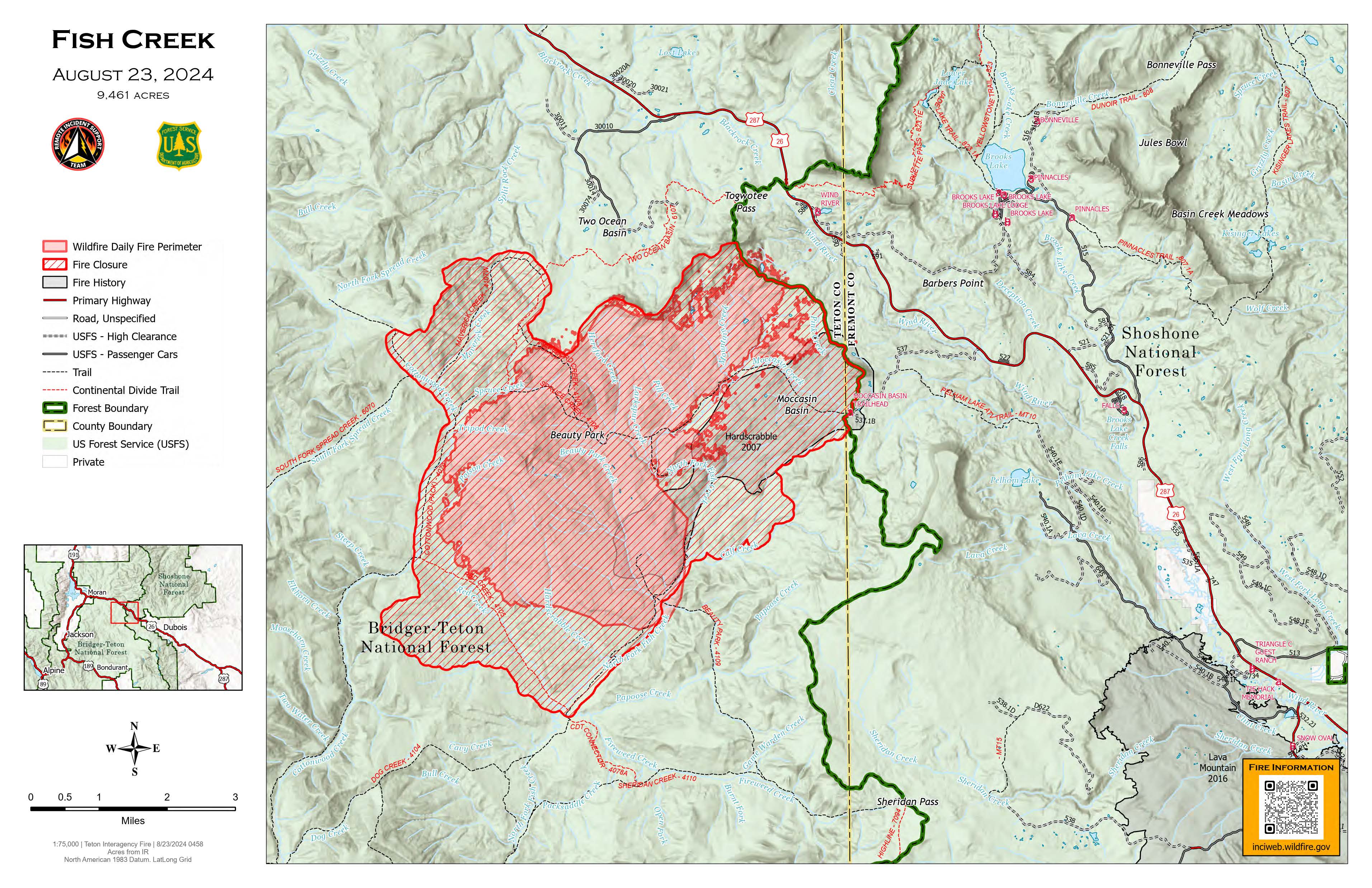
Fish Creek Fire Update Friday 08 23 2024
Related Incident:
Publication Type: News
Fish Creek Fire Update
Bridger-Teton National Forest
Jackson, Wyo., August 23, 2024 – The Fish Creek Fire was discovered on Friday, August 16, in a remote area of the North Fork Fish Creek drainage, approximately 7 miles southwest of Togwotee Pass. The lightning-caused fire is approximately 9,461-acres in size burning in heavy timber, litter, understory and standing dead trees.
US HWY 26/287 continues to have heavy smoke and limited visibility. Wyoming Department of Transportation (WYDOT) is working closely with Fremont County Emergency Management and fire officials for the safety of motorists and firefighters. Drivers are encouraged to visit https://www.wyoroad.info/ prior to traveling on US HWY 26/287 for road status and information, or download the Wyoming 511 app at https://www.wyoroad.info/511/WY511Mobile.html.
Today, crews will be working on spot fires around the Pilot Knob area to tie in the perimeter of the fire. Spot fires occur when floating embers drift in the air on the unburned side of a fire containment line. Spot fires can show up hours to days after embers land in distant location. Management will be monitoring areas of these spot fire concerns, and aviation resources are supporting crews in spot fire suppression to protect resources and values at risk.
Residents of the Brooks Lake, Pinnacle Drive and Breccia Drive area remain in the Level 2 Evacuation notice. A Level 2 Evacuation means “Be Set” to evacuate. You must prepare to leave at a moment’s notice. This level indicates there is significant danger to your area, and residents should either voluntarily relocate to a shelter or with family/friends outside of the affected area, or if choosing to remain, to be ready to evacuate at a moment's notice. See the alert notice on the Fremont County Fire Protection District Facebook page.
Temperatures will be cooler today and moisture is expected over the fire. Although rain can produce relief on a fire, winds can produce challenges for firefighters. With incoming inclement weather through the weekend, fire managers expect growth of the Fish Creek Fire.
The Fish Creek Area, Roads, and Trails Closure Order (map) has been established for public and firefighter safety. See full details at https://www.fs.usda.gov/alerts/btnf/alerts-notices.
For more information on the Fish Creek Fire, please visit the InciWeb page at https://inciweb.wildfire.gov/incident-information/wybtf-fish-creek-fire.
For other news, events and information about the Bridger-Teton National Forest, call 307-739-5500, visit the Forest website at https://www.fs.usda.gov/btnf and follow the Bridger-Teton on Facebook and X (formerly Twitter) @BridgerTetonNF.
USDA is an equal opportunity provider, employer and lender.
Park Fire Evening Update 08 22 2024
Related Incident: Park Fire
Publication Type: News
Park Fire Evening Update for August 22 is posted on the Park Fire Status Update Page
Borel Post Fire Burned Area Emergency Response BAER Information 08 22 2024
Related Incident: Borel Fire
Publication Type: Announcement
For more information on the Borel Post Fire Burned Area Emergency Response (BAER), please visit Borel Postfire Baer Information | InciWeb (wildfire.gov).