
Actualizacin diaria del incendio Easy 19 de agosto de 2024 08 19 2024
Related Incident: Easy Fire
Publication Type: News
Datos clave
Clave: 2,130 acres
Fecha de inicio: 17 de julio de 2024
Ubicación: 17 millas al oeste de Mazama, WA
Contención: 29%
Personal asignado: 219
Causa: Rayo
Recursos asignados: 6 equipos de obreros, 9 camiones de bomberos, 5 tanques de agua
Habrá una sesión informativa virtual comunitaria el miércoles 21 de agosto a las 5:30 pm
Vea la sesión informativa virtual comunitaria en la página de Facebook de información de los incendios Pioneer e Easy en https://www.facebook.com/profile.php?id=61560760893080. Envíe sus preguntas con antelación a 2024.pioneer@firenet.gov o a través de Facebook Messenger.
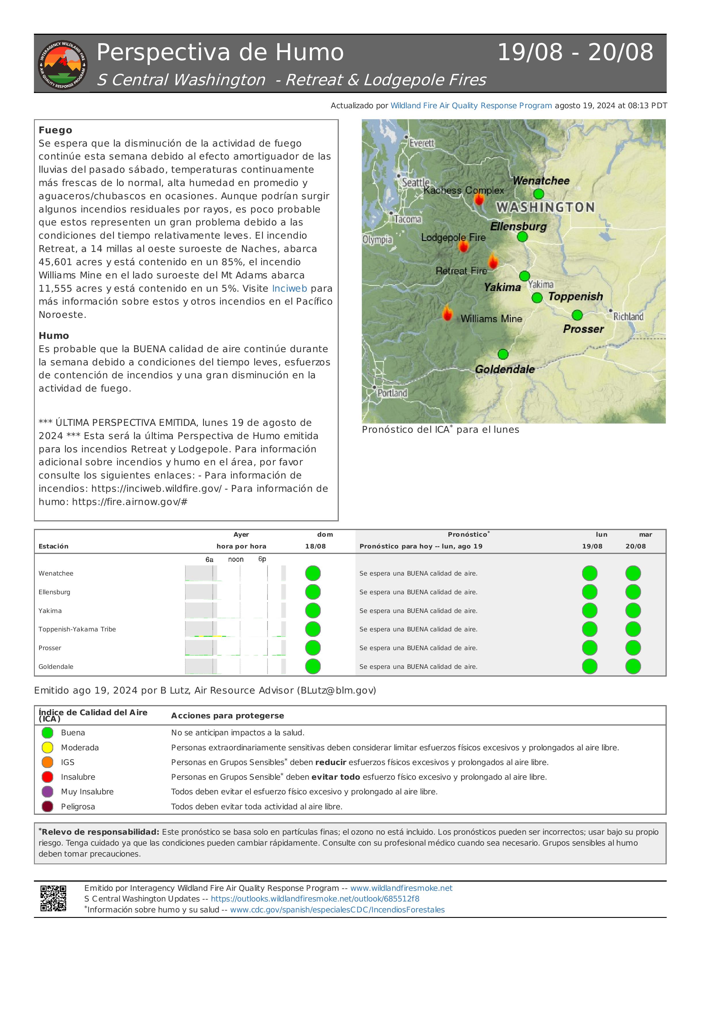
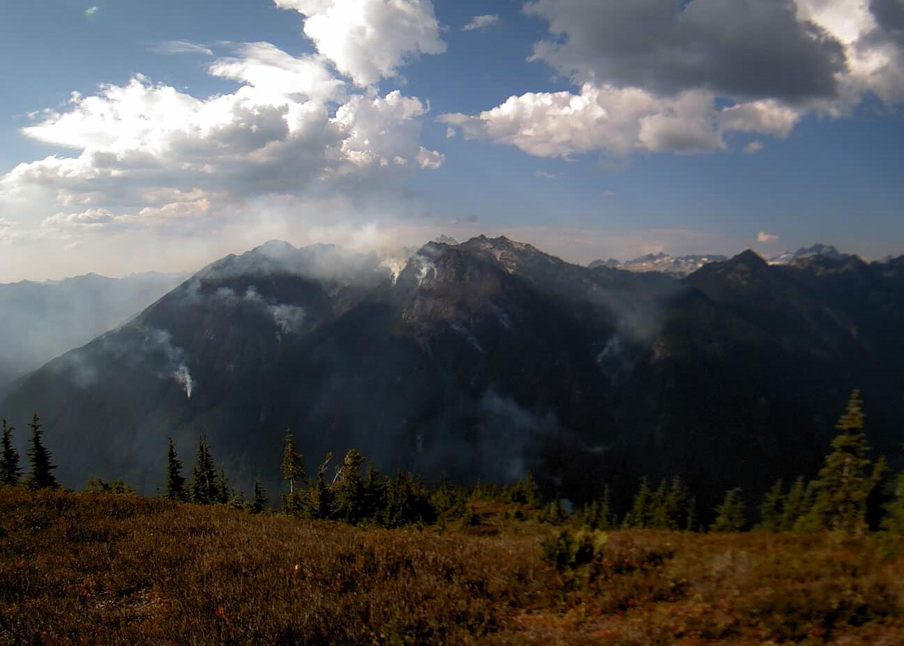
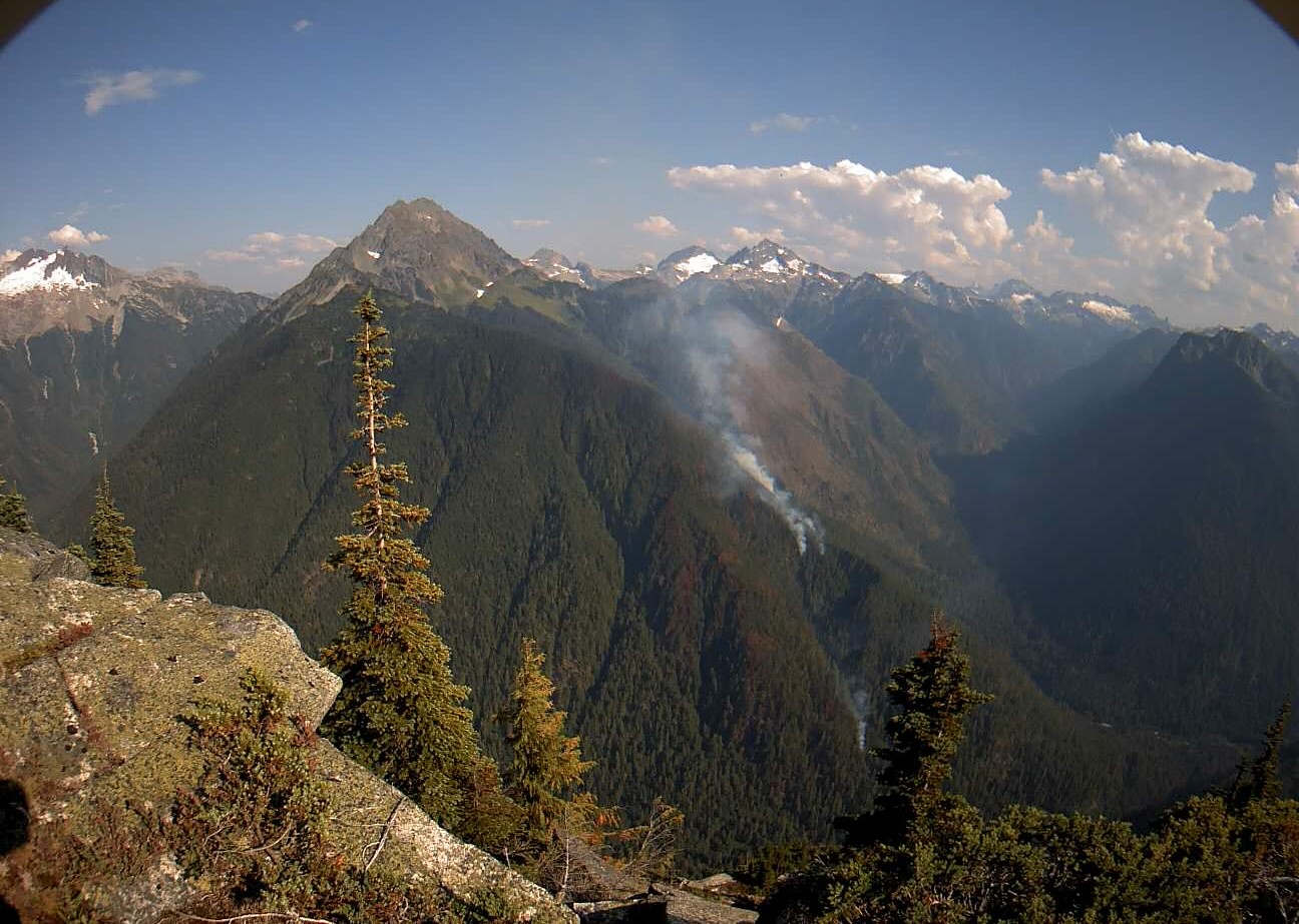
SITUACIÓN ACTUAL: El incendio Easy continúa dentro de su huella establecida, aunque todavía permanecen algunas áreas de calor disperso. Las lluvias del sábado por la noche fueron útiles para enfriar los combustibles más ligeros en las áreas abiertas, pero no saturaron el suelo en las áreas con árboles densos. El calor se encontró en los combustibles más pesados del extremo norte y oeste del incendio y se enfrió con agua vertidad de helicópteros. Las cuadrillas trabajaron para remover los árboles muertos y caídos para minimizar la posibilidad de fuegos salpicados a lo largo de la carretera 20 y para reforzar la carretera como una línea de retención de fuego. Han neutralizado 100 pies desde la carretera a lo largo de la línea de contención. Los sistemas de aeronaves no tripuladas (UAS, por sus siglas en inglés) continuaron encontrando calor en el desague de Swamp Creek, donde es limitado el acceso debido al terreno escarpado y los peligros por arriba. Los helicópteros siguen ayudando al verter agua.
ACTIVIDADES DE HOY: Los bomberos siguen sosteniendo y mejorando las características de control en la parte sur del incendio Easy. Continuarán utilizando sistemas de aeronaves no tripuladas (UAS, por sus siglas en inglés) para volar sobre la huella del incendio y detectar focos de calor e informar a los bomberos dónde enfocar sus esfuerzos. Los recursos continuarán apoyando al Departamento de Transporte de Washington al remover rocas, lodo y escombros de árboles a lo largo de la carretera 20. Los bomberos permanecen listos para ayudar con cualquier ataque inicial contra posibles nuevos fuegos que resulten de rayos recientes en el área.
CLIMA y HUMO: El día de hoy estará soleado con una ligera brisa y una probabilidad muy baja de tormentas eléctricas. Las temperaturas estarán entre los 70 y los 80 grados y se mantendrán dentro del rango de temperatura promedio mensual toda la semana. La posibilidad de tormentas eléctricas el lunes por la noche y hasta el martes aumenta al 55%, con mayores probabilidades de que llueva toda la semana. El pronóstico del humo para los incendios Pioneer e Easy Fires está disponible en https://outlooks.airfire.org/outlook/f79a6d6d.
CIERRES: La carretera 20 está cerrada en ambas direcciones entre Granite Creek (MP 148) y Rainy Pass (MP 157): Manténgase al día en https://wsdot.com/Travel/Real-time/Map/.
El Bosque Nacional Okanogan-Wenatchee tiene cierres vigentes para los senderos dentro del área del incendio. Para saber más vaya a Okanogan-Wenatchee National Forest - Alerts & Closures (usda.gov). Este cierre incluye una parte del sendero Pacific Crest Trail. Están prohibidas las fogatas. Hay una restricción temporal de vuelo (TFR, en inglés) sobre el área del incendio: https://tfr.faa.gov/save_pages/detail_4_6779.html. La actividad de drones no autorizados está prohibida por la TFR.
EVACUACIONES: No existen órdenes de evacuación para el incendio Easy. Cualquiera que utilice la zona para recrearse debe estar atento a su entorno y permanecer fuera de las áreas cerradas.
InciWeb: https://inciweb.wildfire.gov/incident-information/waowf-easy-fire
Facebook: https://www.facebook.com/profile.php?id=61560760893080
Línea de información sobre el incendio: 541-861-5808, 8 AM to 8 PM
Correo electrónico: 2024.easy@firenet.gov
Middle Fork Complex Bull Trout Wapiti Fire Update Sunday 08 18 2024
Related Incident: Bulltrout Fire
Publication Type: News
Incident Commander: Rick Connell, Northern Rockies Team 5
Middle Fork Complex Location: 9 miles east of Garden Valley, ID
Bull Trout Location: 15 miles WNW of Stanley, ID Wapiti Location: 2 miles southwest of Grandjean, ID
Start Dates: 07/24/24 – 08/06/2024
Cause: Lightning
Size:
Bull Trout: 271 acres Wapiti: 4,943 acres
Middle Fork Complex: Bulldog: 4,392 acres Nellie:11,237 acres
Containment: Middle Fork Complex: 5% Wapiti: 10% Bull Trout: 92%
Resources on site:
Middle Fork Complex: 2 hotshot crews; 5 type 2 hand crews; 9 engines; 1 bulldozer; 2 water tenders;
1 skidgen
Wapiti: 1 type 2 hand crew; 8 engines; 1 water tender
Bull Trout: 2 engines
Total Personnel: Middle Fork Complex: 342 Wapiti: 82 Bull Trout: 22
KEY MESSAGE:
Yesterday a red flag warning was in effect for hot, dry and unstable conditions across the area. Most fires in the area saw increased activity and growth as a result of the hot, dry, windy conditions. Fires were active late into the night. On the Wapiti Fire, due to the increased fire behavior, some structures near the Wapiti Summer Home area were impacted. Firefighters are currently assessing the impacts to these structures.
Join us for a Middle Fork Complex, Bull Trout, and Wapiti Fire Community Meeting today, August 18, 2024, at 7pm for an in-person explanation of current fire activity and planned actions on these fires. The Community Meeting will be located at the Crouch Community Center, 1022 Old Crouch Road.
CURRENT STATUS/PLANNED ACTIONS:
Middle Fork Complex: The Middle Fork Complex is comprised of the Bulldog and Nellie fires.
Yesterday the Bulldog Fire grew over 680 acres to the north and east due to southwest winds. The south/southwest line held and continued to be maintained and improved throughout the day. Today crews will continue along the ridge line to the north holding and improving the previously built fire line. The fire is expected to grow to the north/ northeast with weather conditions today. The public is reminded that the Middlefork Road (FS Road 698) is closed at the Forest Service boundary just north of Lightning Creek and the Scriver Creek Road (FS Road 693) is also closed at the Forest Service Boundary for firefighter and public safety as crews continue to work to protect private property and structures in the vicinity of Crouch.
The Nellie Fire experienced increased fire activity yesterday and burned into the night growing over 4,000 acres to the north and west. Firefighters will continue point protection at lookouts and a communication tower. Air resources continue to support the fire by cooling the fire’s edge. Smoke will remain visible as weather conditions remain hot and dry. The public is reminded that Forest Service Road #555 is closed at the intersection of Highway 17 all the way to the Forest Service Road #579 intersection.
Wapiti Fire: Yesterday, the Wapiti Fire experienced active fire behavior and spotting due to the red flag conditions, terrain and shifting winds. The fire spotted into the 2018 Wapiti fire area and firefighters and helicopters responded to the increased activity. Some structures within the Wapati Summer Home area were impacted by the fire. Today, firefighters are assessing the impacts from the fire and more information will be made available when available.
Bull Trout Fire: The Bull Trout fire is still 92% contained, with little heat observed yesterday. Due to falling dead and live trees, crews cannot safely access the interior of the fire and will continue to patrol the perimeter.
WEATHER AND FIRE BEHAVIOR:
Yesterday a red flag warning was in effect through the evening for hot, dry and unstable conditions across the area. Overnight conditions allowed for continued fire activity until after midnight, with light downslope, down valley winds. Today, critical fire weather conditions continue however a Red Flag Warning has not been issued. The morning inversion will lift early this afternoon allowing relative humidity values to drop for the remainder of the day. Winds will remain terrain driven, across most sheltered areas with southwest winds across the fire area. Backing, group tree torching, and long-range spotting with wind and terrain influenced movement is expected today.
CLOSURES, RESTRICTIONS, AND EVACUATIONS:
Middle Fork Complex: The Boise County Sheriff's Office continues to maintain the Level 2 evacuation notice for residents on and near the Middlefork Road between Stump Ranch Road up to Tie Creek Campground. The Boise National Forest issued an area closure for the fire (Closure #0402-06-59) effective August 12, 2024. The purpose of this order is to protect public safety during the fires.
Wapiti Fire: The evacuation order for Summer Homes and the Sawtooth Lodge remain in effect for the Wapiti Fire, as does the area closure issued by the Sawtooth and Boise National Forests (Closure #0402-05-94) effective August 12, 2024. This Order is for public and firefighter safety during fire suppression efforts of the Wapiti Fire.
Bull Trout Fire: The Bull Trout Fire Area Closure (Closure #0402-05-93) remains in effect for the roads and trails within the perimeter of the fire. The Boise National Forest issued this order on August,12, 2024. It will be rescinded as soon as it is safe to do so.
Closure information and maps are posted on the Forest’s website and the fire’s Inciweb page as they are in place. https://tinyurl.com/2u8v3pf7
The Boise National Forest, Idaho Department of Lands, and Bureau of Land Management are in Stage 1 fire restrictions on state, endowment, private and federal lands within the West Central Mountains Fire Restrictions Zone. For more information on the restrictions and a map visit:
https://www.idl.idaho.gov/fire-management/fire-restrictions-finder/
Easy Fire Update 08 19 2024
Related Incident: Easy Fire
Publication Type: News
Easy Fire Update
August 19, 2024
Quick Facts
Size: 2,130 acres
Start Date: July 17, 2024
Location: 17 miles west of Mazama, WA
Containment: 29%
Personnel Assigned: 219
Cause: Lightning
Resources Assigned: 6 crews, 9 engines, 5 water tenders
Virtual Community Briefing on Wednesday, August 21 at 5:30 pm
View the live virtual community briefing on the Pioneer and Easy Fires Information Facebook Page at https://www.facebook.com/profile.php?id=61560760893080. Please submit questions in advance to 2024.pioneer@firenet.gov or via Facebook Messenger.
CURRENT SITUATION: The Easy Fire continues to hold within it’s established footprint though some areas of scattered heat remain. The rainfall on Saturday night was helpful in cooling lighter fuels in open areas on the fire but failed to saturate the ground in the more heavily timbered areas. Heat was found in the heavier fuels of the northern and western edge of the fire and were cooled by helicopter water bucket drops. Crews worked to remove dead and down trees to reduce the possibility of spot fires along Highway 20 and to reinforce the highway as a holding line for the fire. They have mopped up 100 feet in from the highway along the containment line. Unmanned aircraft systems (UAS) continued to find heat in the Swamp Creek drainage where access is limited due to steep terrain and over head hazards. Helicopters continue to support with bucket drops.
TODAY’S ACTIVITIES: Firefighters continue to hold and improve holding features on the southern portion of the Easy Fire. Firefighters will continue to utilize unmanned aircraft systems (UAS) to fly over the fire footprint to detect hot spots and inform firefighters of where to focus their efforts. Resources will continue to support Washington Department of Transportation in the removal of rocks, mud and tree debris along Highway 20. Firefighters remain ready to assist with any initial attack on potential new fires that may result from recent lightning in the area.
WEATHER and SMOKE: Today will be sunny with a slight breeze with a very slim chance of thunderstorms. Temperatures will be in the higher 70s or lower 80s and will remain within the monthly average temperature range throughout the week. The likelihood of thunderstorms on Monday night and into Tuesday increases to 55% with higher chances of rain continuing throughout the week. A smoke outlook for the Pioneer and Easy Fires is available at: https://outlooks.airfire.org/outlook/f79a6d6d.
CLOSURES: Highway 20 is closed in both directions between Granite Creek (Mile Post 148) and Rainy Pass (Mile Post 157): Stay up to date at wsdot.com/Travel/Real-time/Map/
The Okanogan-Wenatchee National Forest has closures in place for trails within the fire area, for more information visit Okanogan-Wenatchee National Forest - Alerts & Closures (usda.gov). This closure includes a portion of the Pacific Crest Trail. Campfires are prohibited. There is a Temporary Flight Restriction (TFR) in place over the fire: https://tfr.faa.gov/save_pages/detail_4_6779.html. Unauthorized drone activity is prohibited under the TFR.
EVACUATIONS: There are no evacuations in place for the Easy Fire. Anyone recreating in the area should be vigilant of surroundings and stay out of closed areas.
InciWeb: https://inciweb.wildfire.gov/incident-information/waowf-easy-fire
Facebook: https://www.facebook.com/profile.php?id=61560760893080
Fire Information Line: 541-861-5808, 8 AM to 8 PM
Email: 2024.easy@firenet.gov
Actualizacin diaria del incendio Pioneer 19 de agosto de 2024 20240819 08 19 2024
Related Incident:
Publication Type: News
Tamaño: 38,727 acres
Fecha de inicio: 8 de junio de 2024
Ubicación: 31 millas al NO de Chelan, WA
Contención: 23%
Personal: 622
Causa: A ser determinada
Recursos asignados: 5 equipos de obreros, 6 helicópteros, 21 camiones de bomberos, 25 tanques de bomberos, 10 maquinarias pesadas
Habrá una sesión informativa virtual comunitaria el miércoles 21 de agosto a las 5:30 pm
Vea la sesión informativa virtual comunitaria en vivo en la página de Facebook de información de los incendios Pioneer e Easy en https://www.facebook.com/profile.php?id=61560760893080. Envíe sus preguntas con antelación a 2024.pioneer@firenet.gov o a través de Facebook Messenger.
SITUACIÓN ACTUAL: En Stehekin, las cuadrillas en el incendio Pioneer continuaron el trabajo de neutralización a lo largo de la línea de mano cerca de Little Boulder Creek para fortalecer esa línea aún más. Los recursos aéreos ayudaron con las operaciones a lo largo del desague de Rainbow Creek vertiendo agua en áreas de calor para mantener bajo control la línea de mano en el área. Se completó el trabajo de remover arbustos y ramas para fortalecer el espacio defendible de las estructuras. En el extremo sure del incendio y cerca de Manson sigue el cepillado de las carreteras y la maquinaria pesada comenzó a irse del área. Los recursos aéreos y terrestres de extinción de incendios asignados al incendio Pioneer ayudaron al personal de la agencia local con el ataque inicial de nuevos fuegos adicionales en el área causados por la tormenta eléctrica del sábado por la noche.
ACTIVIDADES DE HOY: Los bomberos continuarán manteniendo el fuego por debajo de la línea de control en Rainbow Ridge. Asegurarán y mejorarán aún más las líneas de mano cerca de los desagues de Boulder Creek y Rainbow Creek, a medidad que los helicópteros vierten agua para enfriar los focos de calor a lo largo del borde del incendio. Empezará a concluír el trabajo de eliminar obstáculos para minimizar los peligros alrededor de la planta hidroeléctrica de Stehekin. Continuarán los preparativos de estructuras en esta área. Las cuadrillas continuarán removiendo la maleza y la vegetación a lo largo de las líneas de contingencia al este de Manson. Los recursos aéreos estarán disponibles para realizar vuelos de reconocimiento y verter agua. Los bomberos permanecen disponibles para cualquier atague inicial que se necesite en el área alrededor.
CLIMA y HUMO: El día de hoy continúan las condiciones climáticas moderadas con cielos mayormente soleados y temperaturas en los 80 grados. Hay un 10% de posibilidad de lluvias con vientos ligeros por la mañana que aumentarán y soplarán lago abajo a lo largo del día. El pronóstico del humo para los incendios Pioneer e Easy Fires está disponible en https://outlooks.airfire.org/outlook/f79a6d6d.
EVACUACIONES: Se redujeron los niveles de evacuación en el incendio Pioneer en la parte norte de Lake Chelan a partir de las 12 p.m. del domingo 18 de agosto:
- Nivel 2 (Estar preparado): El Stehekin Valley, desde High Bridge sur hasta Adams Point
- Nivel 1 (Manténgase alerta): Desde (and including) Adams Point sur hasta Camas Creek
Aunque han cambiado los niveles de evacuación en el área de Stehekin, el área permanece cerrada a los visitantes. Para ver más información, visite: https://www.co.chelan.wa.us/emergency-management/pages/active-emergencies
CIERRE DEL BOSQUE: Cierres vigentes del Parque nacional North Cascades: https://www.nps.gov/noca/index.htm
El Bosque Nacional Okanogan-Wenatchee ha emitido una orden de cierre sobre gran parte del área afectada por el incendio: Okanogan-Wenatchee National Forest - Alerts & Closures (usda.gov). Las fogatas están prohibidas. Hay una restricción temporal de vuelo (TFR, en inglés) sobre el área del incendio: https://tfr.faa.gov/save_pages/detail_4_6779.html. La actividad de drones no autorizados está prohibida por la TFR.
InciWeb: https://inciweb.wildfire.gov/incident-information/wases-pioneer
Facebook: https://www.facebook.com/profile.php?id=61560760893080
Línea de información sobre el incendio: 541-861-5808, de 8 AM a 8 PM
Correo electrónico: 2024.pioneer@firenet.gov
Miners Complex Daily Update 08 19 2024
Related Incident: Miners Complex Fires
Publication Type: Announcement
11:00 AM, August 19, 2024
Estimated size: 1,098 acres
Start Date/Time: July 17, 2024
Area of Origin: 21 air miles east of Darrington WA
Cause: Lightning
Fuels/Topography: timber, rugged terrain
Structures Damaged: None, there are no homes threatened at this time.
Evacuations: None
The Miners Complex consists of ten wildfires caused by lightning strikes in the Mt. Baker-Snoqualmie National Forest. The fires included in the complex are: Miners Fire, Vista Ridge Fire, Dolly Creek Fire, Sulphur Three Fire, Sulphur Four Fire, Sulphur Thirty-Four Fire, Upper Sulphur Thirty-Two Fire, Lower Sulphur Thirty-Two Fire, Plummer, and Middle Ridge Fire.
Update: During the day on Saturday August 17th, the fires showed active behavior and visible smoke with the rise in temperatures. Rain accompanying the thunderstorms on the evening of the 17th and 18th brought moisture and provided good overnight recoveries. The fires remain high in the mountains in inaccessible ground. The fires may see an increase in activity with warmer weather, however predicted high humidities for the next few days will help fuels recover overnight.
Weather: Good humidity recovery this morning with some scattered clouds through the day will keep temperatures a bit cooler at the fire today. However, modest instability will develop and maintain decent mixing this afternoon. An approaching front will bring increased clouds, rain showers, and an isolated thunderstorm Tuesday afternoon and evening. While some rain is expected with these, a wetting rain is generally not expected with this system. Mostly sunny today, max temperatures will be around 71. Light winds becoming west 5 to 6 mph in the afternoon.
Smoke: For more information on smoke and air quality please visit: https://wasmoke.blogspot.com/
Closures: The following is a summary of the areas closed due to the fires in the Miners Complex. Pacific Crest National Scenic Trail #2000.2 from Mica Lake to Suiattle Pass, Suiattle River Trail #784, Miners Ridge Trail #785, Buck Creek Pass Trail #789, Miners Cabin Trail #795, Grassy Point Trail #788, Sulphur Mountain Trail #794, Sulphur Creek Trail #793, Sulphur Creek Campground, Sulphur Creek Trailhead, and the Downey Creek trailhead. The full Closure Orders visit: https://www.fs.usda.gov/mbs
Forest Restrictions: The Mt. Baker-Snoqualmie has a full campfire ban and forest-wide shooting restrictions in place to help prevent human-caused starts during this period of unprecedented resource scarcity. Additional details at: www.fs.usda.gov/mbs
###
Pioneer Fire Update 08 19 2024
Related Incident:
Publication Type: News
Pioneer Fire Update
August 19, 2024
Quick Facts
Size: 38,727 acres
Start Date: June 8, 2024
Location: 31 miles NW of Chelan, WA
Containment: 23%
Personnel: 622
Cause: Under investigation
Resources Assigned: 5 crews, 6 helicopters, 21 engines, 25 water tenders, 10 heavy equipment
Virtual Community Briefing on Wednesday, August 21 at 5:30 pm
View the live virtual community briefing on the Pioneer and Easy Fires Information Facebook Page at https://www.facebook.com/profile.php?id=61560760893080. Please submit questions in advance to 2024.pioneer@firenet.gov or via Facebook Messenger.
CURRENT SITUATION: In Stehekin, crews on the Pioneer Fire continued mop up operations along the handline near Little Boulder Creek to further secure the line. Air resources supported operations along the Rainbow Creek drainage by dropping water buckets on areas of heat to keep handline in the area in check. Shrub removal and limbing work was completed to secure defensible space of structures. Brushing of roads continued on the south end of the fire near Manson and heavy equipment began to move out of the area. Aerial and ground firefighting resources assigned to the Pioneer Fire assisted local agency personnel with initial attack of additional new fire starts in the area following Saturday night’s thunderstorm.
TODAY’S ACTIVITIES: Firefighters will continue operations to hold the fire below the check line on Rainbow Ridge. They will further secure and improve handlines near Boulder Creek and Rainbow Creek drainages while helicopters drop water to cool hot spots along the fire’s edge. Snag removal operations to mitigate hazards will begin to wrap up around the Stehekin hydropower plant. Structure preparations in this area will continue. Crews will continue to remove brush and vegetation along the contingency lines east of Manson. Air resources will be available for reconnaissance flights and water drops. Firefighters remain available for initial attack needs in the surrounding area.
WEATHER and SMOKE: Moderate weather conditions continue today with mostly sunny skies and temperatures in the low 80s. There is a 10% chance of showers with light morning winds that increase and become down lake throughout the day. A smoke outlook for the Pioneer and Easy Fires is available at https://outlooks.airfire.org/outlook/f79a6d6d.
EVACUATIONS: Evacuation levels on the Pioneer Fire on Lake Chelan's north shore were downgraded beginning at 12 p.m. on Sunday, Aug. 18:
- Level 2 (Be Prepared): The Stehekin Valley, from High Bridge south to Adams Point
- Level 1 (Stay Alert): From (and including) Adams Point south to Camas Creek
While evacuation levels in the Stehekin area have changed, the area remains closed to visitors. For more information, please visit: https://www.co.chelan.wa.us/emergency-management/pages/active-emergencies
CLOSURES: Current closures for the North Cascades National Park: https://www.nps.gov/noca/index.htm
The Okanogan-Wenatchee National Forest has a closure order in place for much of the fire area: Okanogan-Wenatchee National Forest - Alerts & Closures (usda.gov). Campfires are prohibited. There is a Temporary Flight Restriction (TFR) in place over the fire: https://tfr.faa.gov/save_pages/detail_4_6779.html. Unauthorized drone activity is prohibited under the TFR.
InciWeb: https://inciweb.wildfire.gov/incident-information/wases-pioneer
Facebook: https://www.facebook.com/profile.php?id=61560760893080
Fire Information Line: 541-861-5808, 8 a.m. to 8 p.m.
Email: 2024.pioneer@firenet.gov
Pincer Two Fire Daily Update 08 19 2024
Related Incident: Pincer Two Fire
Publication Type: Announcement
11:00 AM, August 19, 2024
Estimated size: 189 acres
Start Date/Time: July 17, 2024
Area of Origin: Johannesburg Mountain. 1 Mile East of Mineral Park C.G.
Cause: Lightning
Fuels/Topography: Timber, rugged terrain
Structures Damaged: None, there are no homes threatened at this time.
Evacuations: None
Closures: Cascade River Road at and including Marble Creek Campground, Mineral Park Campground, and all tributary roads, trailheads, and trails are all closed. The public is not to enter the area for public and firefighter safety.
Full closure orders available at: https://www.fs.usda.gov/mbs
Update: Visible smoke and an increase activity occurred during the day on Saturday, August 17th with the warmer weather, but rains in the evening on the 17th and 18th provided some relief. The fire is slowly burning down the south slope towards the 1590 road and firefighters are watching for any burning debris falling down the hill. The north side of the fire towards Cascade River Road has shown minimal activity over the last few days. Predicted high humidities for the next few days will help fuels recover overnight.
Weather: Good humidity recovery this morning with some scattered clouds through the day will keep temperatures a bit cooler at the fire today. However, modest instability will develop and maintain decent mixing this afternoon. An approaching front will bring increased clouds, rain showers, and an isolated thunderstorm Tuesday afternoon and evening. While some rain is expected with these, a wetting rain is generally not expected with this system. Mostly sunny today, max temperatures will be around 71. Light winds becoming west 5 to 6 mph in the afternoon.
Smoke: For more information on smoke and air quality please visit: https://wasmoke.blogspot.com/
Air Space Restrictions: There are no air space restrictions at this time.
Forest Restrictions: The Mt. Baker-Snoqualmie has a full campfire ban and forest-wide shooting restrictions in place to help prevent human-caused starts during this period of unprecedented resource scarcity. Additional details at: www.fs.usda.gov/mbs
###
Red Fire Daily Update 08192024 08 19 2024
Related Incident: Red Fire
Publication Type: News
RED FIRE DAILY UPDATE
Monday, August 19, 2024
541-208-1766, 2024.red@firenet.gov https://inciweb.wildfire.gov/incident-information/ordef-red-fire
https://www.facebook.com/2024RedFireOR/
Size: 730 acres
Start Date: July 17, 2024 Cause: Lightning Containment: 0% Total Personnel: 152
Location: 5 miles west of Crescent Lake Junction, OR County: Klamath
Crescent, OR – The Red Fire is burning within the Diamond Peak Wilderness of the Deschutes National Forest, on the southwest slope of Redtop Mountain. The fire continues being managed under a full suppression strategy. Public and firefighter safety is the highest priority in managing this fire.
Yesterday’s Activities – The second phase of shaded fuel break work, the felling and processing of trees and brush, progressed along the Crescent Lake summer homes. Larger trees are being removed off-site for storage and truck activity remained heavy on the closed road areas.
Today’s Activities – This morning at 6 a.m. the Northern Rockies Incident Management Team 8 assumed command of the fire. They thanked the Southern Area ‘Gray’ Team for leaving behind a well-executed plan and foundation to build on. The Gray Team sends their appreciation to the crews and resources for excellent work, and thanks the La Pine community for their hospitality. Crews will inspect and finalize hose lays and sprinklers at structures adjacent to Crescent Lake. The felling and processing of trees with heavy equipment will continue on the shaded fuel break from Crescent Lake west to Summit Lake.
Weather and Smoke – Weather will continue to be favorable for fire suppression. Winds are expected to be around 7-10 mph out of the west with temperatures in the mid-60s, with fire activity limited to creeping and smoldering. Air quality information can be found at https://fire.airnow.gov/.
Closures – The Deschutes National Forest emergency closure around Crescent Lake and in Diamond Peak Wilderness is still in effect. The public should note that Forest Service Road 60 is closed, and road guards have been posted for public safety. More closure information is available at: https://www.fsa.gov/alerts/deschutes/alerts -notices/?aid=89091
Evacuations – The WILDFIRE! Level 1 – BE READY to Evacuate notice issued by Klamath County Emergency Management for Crescent Lake, Odell Lake, and Crescent Junction areas remains in effect (INCENDIO FORESTAL! Nivel 1 - ESTÉ PREPARADO para evacuar de las siguientes zonas: Crescent Lake, Odell Lake, Crescent Junction). Visit www.klamathcounty.org/300/emergency-management for more information or to sign up for alerts.
Fire Restrictions – Stage 2 Public Use Fire Restrictions – which prohibit open fires, including in developed campgrounds – remain in effect for the Deschutes National Forest. The Industrial Fire Precaution Level is currently Level IV “General Shutdown.” Visit fs.usda.gov/detail/deschutes/home/?cid=stelprdb5297376 for more information.
Drone Restrictions – Aerial firefighting is suspended when unauthorized drones (UAS) are in the area. Unauthorized drone use over a fire area poses serious risks to fire personnel and the effectiveness of wildfire suppression operations. If you fly, we can’t.
19 de agosto de 2024 Actualizacin diaria de los incendios Whisky Creek y Sandstone 08 19 2024
Related Incident: Whisky Creek FireSandstone Fire
Publication Type: News
Whisky Creek Tamaño: 2,057 acres | Fecha de inicio: 20 de julio | Causa: De orígen humano, a ser determinada | Contención 9% Sandstone Tamaño: 702 acres | Fecha de inicio: 5 de agosto | Causa: Rayo | Contención: 19% Recursos en total: 730 | Equipos de obreros: 24 | Camiones de bomberos: 9 | Topadoras: 5 | Otras maquinarias pesadas: 24 | Helicópteros: 4
(Odell, Oregón.) – El trabajo de extinción de incendios sigue en el incendio Whisky Creek, a 6 millas al sureste de Cascade Locks, Oregón, y en los incendios Sandstone y Blister Creek, a 9 millas al suroeste de Ripplebrook, Oregón. Los incendios arden en un terreno escarpado y accidentado en el Bosque Nacional Mount Hood, donde los escombros rodantes y los árboles debilitados por el fuego dificultan el trabajo de extinción. La prioridad principal sigue siendo la seguridad de los bomberos y del público. Los encargados de los incendios están aprovechando las condiciones climáticas buenas para evaluar y desarrollar planes para realizar esfuerzos más directos de extinción. A pesar de las lluvias grandes durante la tormenta del sábado, estos incendios siguen activos. Los grandes troncos en llamas y otros materiales caídos no se extinguen fácilmente on evento meteorológico pasajero.
Whisky Creek: Ayer, las cuadrillas se enfocaron en las áreas este y sureste del incendio. Las cuadrillas de mano justo al oeste de Rainy Lake, hacia el sur a lo largo de la montaña Green Point, neutralizaron los focos de calor persistentes. Cerca de allí, en la esquina sureste, completaron las líneas de contención alrededor de todos los fuegos salpicados y terminaron de remover árboles peligrosos. Los operadores de maquinaria pesada terminaron el trabajo a lo largo de los caminos forestales 630 y 650, mientras que sigue el trabajo de remover grandes escombros leñosos y de otro tipo a lo largo de los caminos forestales 2820, al este de la montaña Green Point.
Hoy, las cuadrillas reforzarán las líneas de mano en el extremo este del incendio y vigilarán los fuegos salpicados y contenidos cerca de Black Lake. Las cuadrillas de mano están explorando las partes sur del perímetro en búsqueda de oportunidades para limitar el tamaño de la huella del incendio. Los operadores de maquinaria pesada continuarán trabajando en las carreteras forestales 630 y 2820.
Sandstone y Blister Creek: Ayer, las cuadrillas que vigilaban el borde del incendio Blister Creek no vieron ningún crecimiento. Hacia el este, en el incendio Sandstone y a lo largo de la cresta empinada de Thunder Mountain, las cuadrillas de mano continuaron fortaleciendo la línea hasta Forest Road 4620, además de la esquina suroeste. Los operadores de maquinaria pesada prepararon las carreteras forestales 6320 y 7010.
Hoy, las cuadrillas fortalecerán las líneas de contención desde la cresta de Thunder Mountain hasta Forest Road 4620, que actuará como una línea de contingencia en el extremo noreste del incendio. Se comenzará a remover árboles peligrosos de las líneas de topadoras al suroeste del incendio. Las cuadrillas están colocando mangueras en el extremo sur y este del incendio a lo largo de los caminos de contención.
Clima y intensidad del fuego: Hoy, los cielos parcialmente nublados contribuirán a una mayor humedad y temperaturas más frescas, y condiciones más ligeras que resultarán en una intensidad moderado del fuego. Una baja probabilidad de lluvias dispersas durante la semana pudiera minimizar aún más la intensidad de los incendios.
El público juega un papel importante en la prevención del próximo incendio forestal. Evite causar una presión excesiva sobre los recursos de extinción de incendios al tener cuidado con cualquier fuente de ignición. Para obtener consejos de prevención, visite, https://keeporegongreen.org. Hay restricciones contra incendios dentro del Bosque Nacional Mt. Hood. Se puede ver más información enhttps://www.fs.usda.gov/main/mthood/fire. Se ha establecido una restricción temporal de vuelo (TFR) en ambas áreas de incendio.
Humo: Se espera que la calidad del aire sea buena para ambas áreas de incendio. Para ver más información sobre las condiciones del humo en su área, visite: www.AirNow.gov.
Cierres: Información sobre el cierre del Bosque Nacional Mt. Hood y el Área Escénica Nacional del Río Columbia se puede encontrar en escaneando el código QR o siguiendo el enlace en la esquina inferior derecha de la página. Los cierres se implementarn para la seguridad del público y de los equipos de bomberos.
Para más información sobre los incendios de Whisky Creek y Sandstone, consulte los siguientes recursos:
Correo electrónico: 2024.whiskycreek@firenet.gov or 2024.sandstone.or@firenet.gov Teléfono: 541-208-1743, 8 a.m. – 8 p.m. Sitio web: Escanea el código QR a la derecha o vaya a https://linktr.ee/whisky_creek.2024
Actualizacin Matutina del Incendio Retreat 19 de Agosto 2024 08 19 2024
Related Incident: Retreat
Publication Type: News
Actualización Matutina del Incendio Retreat - 19 de Agosto 2024
Acres totales: 45.601 acres Contención: 85% Cantidad de personal: 228
Esta es la última actualización de incidentes para el incendio Retreat
El Equipo 14 de gestión de incidentes interinstitucionales de California transferirá el mando del incidente a las agencias locales al final de su turno hoy, 19 de agosto de 2024. Si hay algún cambio importante con respecto al incendio Retreat, las agencias locales compartirán la información pertinente en sus sitios web y plataformas de redes sociales.
Situación actual: Debido al trabajo duro de los bomberos, ha aumentado la contención del incendio Retreat y ahora está un estado en el que las agencias locales pueden tomar el control de nuevo del incidente con un número mínimo de recursos. Se ha minimizado la amenaza a las comunidades alrededor, los servicios públicos y los valores en riesgo hasta el punto de que se han levantado todas las órdenes de evacuación y se ha abierto de nuevo la US 12.
Debido a los efectos del incendio Retreat, varios cierres de incendios (vea más abajo) permanecen en efecto hasta nuevo aviso. Las agencias locales continuarán con un número pequeño de bomberos asignados al incidente para que sigan patrullando el área en busca de focos de calor que queden y amenazas a la seguridad pública. Estas cuadrillas se asegurarán de que las líneas de contención continúen en su lugar y que siga bajo control la parte restante del cortafuegos.
Se recuerda al público que esté atento a los bomberos y equipos a lo largo de las carreteras cuando use la US 12. Las personas que viajan, deben planificar tiempo adicional al viajar debido al tráfico de un solo carril y alternado en una sola dirección mientras los equipos de WSDOT y contratistas de emergencia trabajan para reemplazar las barandillas y las señales de carretera a lo largo de la carretera US 12 entre el poste la millas 185, cerca del cruce con la carretera 410 y el poste de millas 168, cerca de la intersección de Tieton Road.
Clima: La baja presión continúa frente a la costa noroeste del Pacífico. Esto resultarán en algunas nubes, junto con algunas lluvias ligeras ocasionales y una poca probabilidad de tormentas eléctricas. Se esperan temperaturas más frescas y alta humedad por la tarde. Se prevé que los vientos del suroeste permanecerán ligeros esta mañana (1 a 5 mph) y luego cambien al noroeste (3-9 mph) con ráfagas de hasta 16 mph por la tarde. Se pronostica que la mayor probabilidad de tormentas eléctricas será el martes y el jueves.
Evacuaciones: Todas las órdenes de evacuación por el incendio Retreat se han levantado a partir del 16 de agosto de 2024.
Cierres por el incendio:
- Cierre por el incendio Retreat en el Bosque Nacional Okanogan-Wenatchee (tinyurl.com/5ext5aec).
- La Región Sureste del Departamento de Recursos Naturales del Estado de Washington (DNR, por sus siglas en inglés) ha cerrado temporalmente parte del Bosque Estatal Ahtanum. El público puede ver la información más actualizada sobre el cierre en dnr.wa.gov/ahtanum.
- El Departamento de Pesca y Vida Silvestre de Washington ha cerrado la mayor parte del Área de Vida Silvestre de Oak Creek al público debido al incendio Retreat hasta el 23 de agosto de 2024. Puede ver más información en tinyurl.com/bdet7845.
Calidad del aire y humo: El pronóstico de la calidad del aire y las condiciones del humo se pueden ver en airnow.gov.