
Updated Wood Lake Fire Closure Area News ReleaseEffective Sept 30 2024 09 30 2024
Related Incident:
Publication Type: Closures
Superior National Forest Restricts Campfire Use Within the Boundary Waters Canoe Area Wilderness & Modifies Wood Lake Fire Closure
Drying conditions continue across northern Minnesota prompts campfire restrictions & modifies closures of lakes and portages around the Wood Lake Fire
Duluth, Minn. September 30, 2024—Due to continued dry conditions and worsening wildfire danger conditions, the Superior National Forest has issued an Emergency Forest Order 09-09-24-08 - effective October 1, 2024 - restricting the igniting, building, maintaining, attending, or using a fire or campfire, including charcoal grills and barbeques, coal, and woodburning stoves to reduce the likelihood of a wildfire within the Boundary Waters Canoe Area Wilderness (BWCAW) of the Superior National Forest. (Forest Order 09-09-24-08).
BWCAW campfire restriction information and Exhibit A-Closure Map: https://www.fs.usda.gov/detail/superior/notices/?cid= BWCAW campfire restrictions go into effect beginning Tuesday morning (00:01) a.m., October 1, 2024. Gas or propane cook stoves are allowed throughout the Superior National Forest, including the BWCAW and are a safer option than campfires. Stoves or grills fueled by charcoal, or any type of wood are not allowed. These restrictions will continue until further notice.
In addition to the campfire restriction effect, the Superior National Forest is reinstating the Wood Lake Fire closure restrictions, to close Wood, Good, Hula, and Indiana Lakes and connecting portages.
“We have seen warmer and dryer conditions across much of the Superior National Forest, especially within the Boundary Waters Canoe Area Wilderness. We want the recreating public to be safe as they enjoy the Forest,” stated Tom Hall, Superior National Forest Supervisor.
The potential for wildfire is high across all ownerships in northern Minnesota at this time. It is extremely important that people area careful with any sources of ignition such as smoking devices, dragging chains, and recreational vehicles. If you are in a location where you can have a campfire outside the Boundary Waters Canoe Area Wilderness, consider if the conditions are right and if you need a fire. Be sure to keep your campfire small and put it out cold to the touch whenever you leave it. All permitted campfires must be attended all times.
For additional information regarding fire-related and/or forest closures and updates:
• Superior National Forest website www.fs.usda.gov/superior, and Superior NF Fire Management
• Minnesota Incident Command System website at www.mnics.org
• SNF Forest Orders are available here USDA is an equal opportunity provider, employer and lender.
• A Special Weather Statement has been issued for counties of the Superior National Forest for near-critical fire weather
• A Red Flag Warning is issued for counties west and southwest of the Superior National Forest: https://mnics.org/wpress/red-flag-warning-issued-5
Updated OREFIREEMERGENCYAREACLOSURE09 30 2024
Related Incident: North Willamette Complex
Publication Type: Closures
UNITED STATES DEPARTMENTOF AGRICULTURE
FOREST SERVICE WILLAMETTE NATIONAL FOREST
SPRINGFIELD, OREGON
ORDER# 06-18-01-24-40 FOREST ORDER
ORE FIRE EMERGENCY AREA CLOSURE
Pursuant to 16 U.S.C. § 551 and 36 CFR § 261.50 (a) and (b), and to provide for public safety, the following acts are prohibited on the National Forest System ("NFS") areas, roads, and trails described below within the administrative boundaries of the Willamette National Forest. Refer to Exhibit A for the map. This Order supersedes Order# 06-18-01-24-31 and is effective on October 1, 2024, through January 1, 2025, unless otherwise rescinded sooner.
PROHIBITIONS:
- Being on the road. 36 CFR § 261.54(e)
- Being on a trail. 36 CFR § 261.55(a)
- Entering into or being upon National Forest System Lands closed for the protection of public health and safety. 36 CFR § 261.53(e)
CLOSURE AREA:
The closure area is located within the State of Oregon, Lane and Linn Counties, and within the Administrative Boundaries of the Willamette National Forest. The closure applies to the NFS areas, roads, and trails and trailheads described below. The closure area is depicted on the attached map, which is incorporated into this order as "Exhibit A". All areas, roads, trails, campgrounds, and recreation sites in this closure area are closed. All roads and trails that serve as the boundary of this closure area are open and passable. Forest Service Trail (FST) 3370 (Gold Hill) and Gold Hill Trailhead are open. Tidbits South Trailhead and FST 3328 (Tidbits South) between the trailhead and FST 3370 are closed.
Area Closure Description
The closure boundary starts at the junction of Forest Service Road (FSR) 15 and FSR 1509. It proceeds along FSR 1509 to the north into the northeast quarter section of section 15 of Township 15 South and Range 5 East where it turns north and then proceeds west along Forest Service Trail (FST) 3328 (Tidbits South) to FST 3370 (Gold Hill). From there, it follows FST 3370 north to the Gold Hill Trailhead and then continues northeast along FSR 1509 to the junction of FSR 1509 and FSR 1513. The closure boundary follows FSR 1513 southeast to the junction of FSR 15 and continues southwest along FSR 15 where it ends at the junction of FSR 15 and FSR 1509.
EXEMPTIONS:
Pursuant to 36 CFR § 261.50(e)(1) and (4), the following persons are exempt from this Order:
Persons with Forest Service Permit No. FS-7700-48 (Permit for Use of Roads, Trails, or Areas Restricted by Regulation or Order) specifically exempting them for this Order.
Any Federal, State, or Local Officer, or member of organized rescue or
fire fighting force in the performance of an official duty.
These prohibitions are in addition to the general prohibitions in 36 CFR Part 261, Subpart A
Violations of these prohibitions are punishable by a fine of not more than $5,000.00 for an individual or $10,000.00 for a corporation or imprisonment for not more than six months or both. 16 U.S.C. § 551 and 18 U.S.C. § 3551, 3571, and 3581.
Executed in Springfield, Oregon on this 30th day of September 2024.
Digitally signed by DONNA MICKLEY
Donna Mickley
Acting Forest Supervisor Willamette National Forest
Settings - change map background and toggle additional layers
Filter - control incident types displayed on map.
Zoom to your location
Reset map zoom and position
Could not determine your location.
Show Legend
 Wildfire
 Prescribed Fire
 Burned Area
Response
Burned Area
Response Other
Other
Yellow Lake Fire
Unit Information
Incident Contacts
UPDATED LINTONCREEKFIREEMERGENCYAREACLOSURE09 30 2024
Related Incident: North Willamette Complex
Publication Type: Closures
UNITED STATES DEPARTMENT OF AGRICULTURE
FOREST SERVICE WILLAMETTE NATIONAL FOREST
SPRINGFIELD, OREGON
ORDER# 06-18-01-24-42 FOREST ORDER
LINTON CREEK FIRE EMERGENCY AREA CLOSURE
Pursuant to 16 U.S.C. § 551 and 36 CFR § 261.50 (a) and (b), and to provide for public safety, the following acts are prohibited on the National Forest System ("NFS") areas, roads, and trails described below within the administrative boundaries of the Willamette National Forest. Refer to Exhibit A for the map and Exhibit B for trails and recreation sites that are closed. This Order supersedes Order# 06-18-01-24-37 and is effective on October 1, 2024, through January 1, 2025, unless otherwise rescinded sooner.
PROHIBlllONS:
- Being on the road. 36 CFR § 261.54(e).
- Being on a trail. 36 CFR § 261.55(a).
- Entering into or being upon National Forest System Lands closed for the protection of public health and safety. 36 CFR § 261.53(e).
CLOSURE AREA:
The closure area is located within the State of Oregon, Lane County, and within the Administrative Boundaries of the Willamette National Forest. The closure applies to the NFS areas, roads, and trails and trailheads described below. The closure area is depicted on the attached map, which is incorporated into this order as "Exhibit A." All areas, roads, trails, campgrounds, and recreation sites inside the boundary of this closure area are closed.
The closure area boundary starts at the Obsidian Trailhead and proceeds southeast along FST 3528 (Obsidian) to the junction with FST 4336 (Glacier Way). It then continues eastward along FST 4336 to the junction with the PCT. Both FST 3528 and FST 4336 are closed and not passable. From the junction at the PCT, the closure boundary heads due east to the Willamette National Forest and Deschutes National Forest boundary line. It then follows the Forest boundary line south until it heads due west to the PCT and FST 3511 (Foley Ridge) junction.
The closure boundary then follows FST 3511 west and then north to the Foley Ridge Trailhead. FST 3511 is open and passable. From the Foley Ridge Trailhead, it follows the Three Sisters Wilderness boundary north to Old Mckenzie Highway 242. The closure boundary then follows Highway 242 northeast to FSR 4200-250 (Frog Camp). It then follows FSR 4200-250 to Obsidian Trailhead, where it started.
Forest Service Trail (FST) 3528 (Obsidian), Obsidian Trailhead, Obsidian Stock Trailhead, FST 4336 (Glacier Way), and the Pacific Crest Trail (PCT) are closed. Recreation sites, trails and campgrounds closed by this order are depicted in "Exhibit B."
Old Mckenzie Highway 242, FST 3532 (Proxy Falls), Proxy Falls Trailhead, FST 3519 (Linton Lake), Linton Lake Trailhead, Linton Lake, FST 3511 (Foley Ridge), and Foley Trailhead remain open. They are marked as open on Exhibit A.
EXEMPTIONS:
Pursuant to 36 CFR § 261.50(e)(1) and (4), the following persons are exempt from this Order:
Persons with Forest Service Permit No. FS-7700-48 (Permit for Use of Roads, Trails, or Areas Restricted by Regulation or Order) specifically exempting them for this Order.
Any Federal, State, or Local Officer, or member of organized rescue or
fire fighting force in the performance of an official duty.
These prohibitions are in addition to the general prohibitions in 36 CFR Part 261, Subpart A
Violations of these prohibitions are punishable by a fine of not more than $5,000.00 for an individual or $10,000.00 for a corporation or imprisonment for not more than six months or both. 16 U.S.C. § 551 and 18 U.S.C. § 3551, 3571, and 3581.
Executed in Springfield, Oregon on this 30th day of September 2024.
Digitally signed by DONNA
DONNA MICKLEY MICKLEY
Donna Mickley
Acting Forest Supervisor Willamette National Forest
Fire Update 09 30 2024
Related Incident: Fall Fire
Publication Type: Announcement
Daily Update September 30, 2024 - No New Growth Overnight, 50% Containment Gained
Fire Information Phone: 986-200-1941 (8 a.m. – 8 p.m.)
Email: Lessa_Peter@firenet.gov
Acres: 407 (corrected after more accurate mapping)
Containment: 0%
Location: 12 miles west of West Chandler, AZ.
Start Date: September 28, 2024 Personnel: 50 Fuels: salt cedar, mesquite timber
Resources: Local fire response resources and 1 hotshot crew | 8 engines | 1 helicopter | air attack
Highlights: No fire growth overnight, evacuations lifted and power restored to residents. 50% containment gained.
Fire Activity: There was no fire growth overnight and more accurate mapping was provided, correcting the fire size to 407 acres. Yesterday, there was some isolated torching at the head and the heel of the fire in which a type 1 helicopter was able to assist with cooling via water drops. Firefighters focused on a pinch point near the head of the fire while all other resources assessed structures threatened and worked on mopping up the fire. At approximately 6 PM MST, power was restored to the area and the evacuation orders were lifted.
Today, crews continued suppression efforts and gained 50% containment on the fire by 11 AM MST. Firefighters will continue to work on suppression the gain further containment and continue mop up.
Weather: An excessive heat warning is in place for mostly sunny conditions and temperatures up to 108 degrees F. Wind is expected to be a max of 2 MPH with very dry conditions (1% relative humidity).
Fire Restrictions and Closures: Fire Restrictions are in place across the fire area and a temporary flight restriction (TFR) is currently in place.
More Information:
InciWeb (Fall Fire): https://inciweb.wildfire.gov/incident-information/azpma-fall-fire
Facebook: https://www.facebook.com/gilariver
Daily Fish Creek Fire Update for Monday 09 30 2024
Related Incident:
Publication Type: News
Jackson Wyo., September 30, 2024 - The Fish Creek Fire saw less active fire behavior yesterday than the neighboring Pack Trail Fire. This can be attributed to the fact that the fire is running into previously consumed fuel along its perimeter and is primarily burning interior pockets of vegetation that are not threatening containment lines. These interior fuels are expected to burn for some time and may produce some smoke under certain weather conditions.
Both the Fish Creek and Pack Trail fires are being jointly managed by the same incident management team which can respond and shift personnel and equipment between the two incidents as needed.
For the most current update on the Pack Trail Fire, please visit that fire's Inciweb site at https://inciweb.wildfire.gov/incident-information/wybtf-pack-trail-fire
Willamette Complex South Daily Update for Monday 09 30 2024
Related Incident: Willamette Complex Fires - South
Publication Type: News
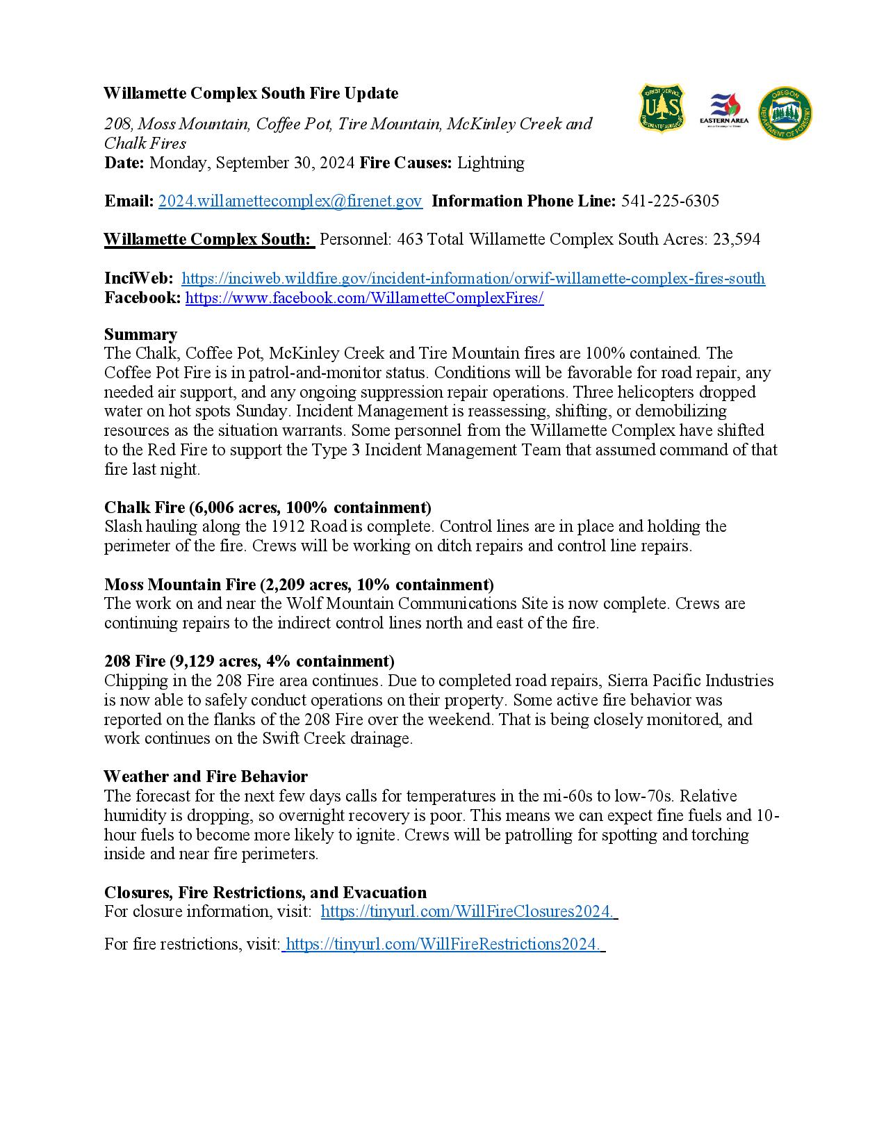
Willamette Complex South Fire Update
208, Moss Mountain, Coffee Pot, Tire Mountain, McKinley Creek and Chalk Fires
Date: Monday, September 30, 2024
Fire Causes: Lightning
Email: 2024.willamettecomplex@firenet.gov
Information Phone Line: 541-225-6305
Willamette Complex South: Personnel: 463 Total Willamette Complex South Acres: 23,594
InciWeb: https://inciweb.wildfire.gov/incident-information/orwif-willamette-complex-fires-south
Facebook: https://www.facebook.com/WillametteComplexFires/
Summary
The Chalk, Coffee Pot, McKinley Creek and Tire Mountain fires are 100% contained. The Coffee Pot Fire is in patrol-and-monitor status. Conditions will be favorable for road repair, any needed air support, and any ongoing suppression repair operations. Three helicopters dropped water on hot spots Sunday. Incident Management is reassessing, shifting, or demobilizing resources as the situation warrants. Some personnel from the Willamette Complex have shifted to the Red Fire to support the Type 3 Incident Management Team that assumed command of that fire last night.
Chalk Fire (6,006 acres, 100% containment)
Slash hauling along the 1912 Road is complete. Control lines are in place and holding the perimeter of the fire. Crews will be working on ditch repairs and control line repairs.
Moss Mountain Fire (2,209 acres, 10% containment)
The work on and near the Wolf Mountain Communications Site is now complete. Crews are continuing repairs to the indirect control lines north and east of the fire.
208 Fire (9,129 acres, 4% containment)
Chipping in the 208 Fire area continues. Due to completed road repairs, Sierra Pacific Industries is now able to safely conduct operations on their property. Some active fire behavior was reported on the flanks of the 208 Fire over the weekend. That is being closely monitored, and work continues on the Swift Creek drainage.
Weather and Fire Behavior
The forecast for the next few days calls for temperatures in the mi-60s to low-70s. Relative humidity is dropping, so overnight recovery is poor. This means we can expect fine fuels and 10-hour fuels to become more likely to ignite. Crews will be patrolling for spotting and torching inside and near fire perimeters.
Closures, Fire Restrictions, and Evacuation
For closure information, visit: https://tinyurl.com/WillFireClosures2024.
For fire restrictions, visit: https://tinyurl.com/WillFireRestrictions2024.
Daily Pack Trail Fire Update for Monday 09 30 2024
Related Incident:
Publication Type: News
Jackson Wyo., September 30, 2024 -The Pack Trail Fire exhibited extreme fire behavior on Sunday, burning in heavy timber and growing substantially with 60-mile per hour wind gusts. The fire grew to 19,608 acres yesterday with red flag conditions. “The fire made a 5-mile wind driven run with crowning and spotting during the afternoon,” said District Ranger Todd Stiles. The extreme fire behavior prompted evacuations and an increase in the evacuation alert level for several subdivisions and ranches in Fremont County, WY. Currently the fire is paused on the ridge between Lava Mountain peak and the old Lava Mountain burn scar, above the Lava Mountain Lodge. “The fire is continuing to burn on the interior right now, and that's expected to continue today,” added Stiles.
Firefighters are assessing the area down ridge from the fire edge and looking for spots where the fire is trying to spread. Structure protection groups have been formed to perform assessments and ready structures along the Wind River corridor with protection apparatus. More resources have been arriving all morning, including firefighting hand crews and additional fire engines. A complex incident management team from California, CA Team 10, is arriving over the next two days and is expected to assume command of the fire late Wednesday, October 2 or early Thursday, October 3.
“The winds are expected to moderate somewhat today, but terrain alignment down canyon is still present, and we are still facing warm temperatures and low humidity,” Stiles said.
The Fish Creek Fire to the north saw less active fire behavior yesterday. For more information on the Fish Creek Fire, visit that fire's Inciweb site at https://inciweb.wildfire.gov/incident-information/wybtf-fish-creek-fire.
Lava Fire Daily Update 09 30 2024
Related Incident:
Publication Type: News
Current Situation:
- The Lava Fire is 82% contained at 97,625 acres, with 532 personnel assigned.
- Suppression repair along the southeast corner is progressing according to plan. Crews are removing unneeded pumps, hoses and other accountable property to return to warehouse.
- Firefighters are working upslope in steep country, mopping up the fire line along the east side of the fire.
- Two shot crews are working the line down low on spot fire across Hurd Creek.
- Along the northern perimeter, firefighters made good work securing Anderson Creek. It will take several more shifts to establish containment on that side of the fire.
- The western perimeter is cold and suppression repair resources are moving north.
- On the Forest Road 653, north of Sage Hen Reservoir, crews are using An Unmanned Aerial system (UAS) to detect heat. Infrared flights are showing less heat daily.
Weather: A cold front passed through the fire area in the late afternoon yesterday. Overnight lows were in the upper 30’s. Highs are expected to be in the mid 50’s, lower 60’s. Today will be warmer and drier. However, fire growth is not expected outside of the fire perimeter.
Evacuations: A Level 1 “READY” notice remains for residents south of South Grays Creek, along Little Weiser River Road in Indian Valley, North of South Grays Creek Road to Highway 95, and the Mesa Area. Valley County Sheriff’s Office has removed Zones 2 & 3 from LEVEL 1 “READY” status. Zones 4 – 6 remain in a LEVEL 1 “READY” Evacuation notice.
Closures: Closures: The Boise and Payette National Forests implemented a joint Lava Fire Area, Road, and Trail Closure for public and firefighter safety. For more closure information see the Payette National Forest website: https://www.fs.usda.gov/alerts/payette/alerts-notices or the Boise National Forest website: https://www.fs.usda.gov/alerts/boise/alerts-notices.
Gem County Road and Bridge issued the following road closures: Third Fork Road at Nesbitt Lane, Second Fork Road at Nesbitt Lane, and Nesbitt Lane. The Sweet-Ola Highway is closed at the High Valley intersection in Ola.
Temporary Flight Restrictions: A temporary flight restriction (TFR) has been updated. View a map of the TFR and details at https://tfr.faa.gov/save_pages/detail_4_8199.html. Fire aviation response is halted or delayed if an unauthorized aircraft enters the TFR. Temporary flight restrictions also apply to unmanned aircraft systems or drones. If you fly, we can’t! Learn more about how to use drones safely and responsibly at Home - Know Before You Fly.
Fire Info Phone: 208-780-5003 Hours: 7:00 a.m. to 7:00 p.m. Email: 2024.Lava@firenet.gov .
Facebook:@LavaFire Inciweb: inciweb.wildfire.gov/incident-information/idbof-lava-fire
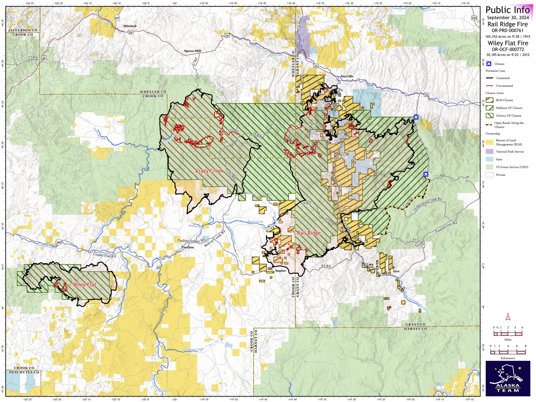
Rail Ridge and Wiley Flat Fire Daily Update 09 30 2024
Related Incident:
Publication Type: News
Rail Ridge and Wiley Flat Fires Daily Update
9-30-24
Rail Ridge Fire
Acres: 165,743 – Containment: 80% – Detection: 09/02/24 – Cause: Lightning – Personnel: 1,038
Operational Update: Yesterday, hot and dry conditions contributed to an increase in acreage on the Rail Ridge Fire. In the Black Canyon Wilderness, the fire crossed Black Canyon Creek onto the ridge east of Honeymoon Basin where firefighters and aerial resources remain engaged. Today’s weather will be much cooler, though winds will be stronger and out of the northwest, and relative humidity will be lower. Weather continues to challenge firefighting efforts. In the northern divisions, firefighters continue to mop up and extinguish isolated heat sources and are working toward suppression repair. Containment continues to increase around the perimeter. In the southern portion of the fire, patrols continue, and suppression repair is ongoing. Repairs continue along roads which received heavy impacts during suppression efforts.
Wiley Flat Fire Final Update
Acres: 30,186 – Containment: 94% – Detection: 09/02/24 – Cause: Lightning – Personnel: 27
Operational Update: Heavy equipment made progress on road repairs and falling teams are removing hazard trees along road corridors. This will be the final daily update for the Wiley Flat Fire. For questions or information moving forward, please contact the Ochoco National Forest at 541-416-6500
Weather: Today’s wind direction will change and come from the northwest. It will be a dry day as relative humidity is expected in the teens. Temperatures will be much cooler, with highs only reaching into the sixties.
Evacuations
Rail Ridge Evacuations: Level 1 and 2 evacuation zones for the Rail Ridge Fire remain in Grant County.
Wiley Flat Evacuations: Level 2 and 3 evacuation zones remain for the Wiley Flat Fire in Crook County.
For Current Evacuation Levels all affected counties, please visit: https://linktr.ee/RailRidgeFire
Closures: The U.S. Forest Service and Bureau of Land Management have implemented closures for the Rail Ridge and Wiley Flat Fires. For more details and closure maps, visit https://linktr.ee/RailRidgeFire
#RailRidgeFire2024 #WileyFlatFire2024 #FireYear2024
