
Community Meeting October 2 2024 10 01 2024
Related Incident: Elk Fire 2024
Publication Type: Announcement
For those directly impacted by the Elk Fire, there will be a community meeting at 7:00 p.m. on Wednesday, October 2, 2024, at the Tongue River Middle School located at 1251 Dayton Street in Dayton. This in-person meeting will be recorded and published on the U.S. Forest Service Bighorn National Forest’s Facebook page.
Highway 35 Closed due to fire activity on Yellow Lake Fire 09 29 2024
Related Incident: Yellow Lake Fire
Publication Type: Closures
Highway 35 is closed between Nobletts Trailhead and Wolf Creek Summit, for both public and firefighter safety. This closure will remain for at least 24-72 hours, until fire activity decreases and the road can be cleared of debris.
Yellow Lake Fire Update 10 01 2024
Related Incident: Yellow Lake Fire
Publication Type: News
The Yellow Lake Fire has been mapped at 2,474 acres and 0% contained. The fire remained active throughout shift yesterday, though cooler temperatures overnight saw moderated fire activity. It continues to burn in heavy timber, both standing and dead-and-downed. Lack of moisture in the area this summer, as well as unseasonably late heat waves this fall, have caused the fuels to be highly receptive to fire, making suppression efforts dangerous and difficult.
Fire managers are inserting ground crews where access is available and safe. The fire was active on the north side, and firefighters utilized air support and fire retardant to slow the progression. However, with the current heat and dry fuels, the fire is slowly burning through the retardant lines.
Crews are doing structure protection at the YMCA camp and near the gas pipeline, using bulldozer line and increasing the fuel break previously created to assist in holding the fire. Other values, including structures and communities not immediately affected by the fire, are being assessed proactively in case of further growth from the fire.
This remains a full suppression fire, but with the current conditions it will likely be a longer duration fire due to the terrain, topography, receptive fuels, and predicted weather.
Fire managers are working with their cooperators and respective county and local agencies to coordinate impact on grazing allotments, logging, and other permittee concerns. They are also working with law enforcement to escort recreationists to retrieve their belongings in the campgrounds and in the closure area.
Highway 35 remains closed, for both public and firefighter safety. This closure will remain for at least 24-72 hours, until fire activity decreases and the road can be cleared of debris.
The fire has been determined to be human caused, but it is still under investigation. More information will be released once the final investigation report has been finalized.
The Yellow Lake Fire is located east of Mill Hollow Reservoir on the Uinta-Wasatch-Cache National Forest. Currently, there are 230 personnel assigned to the fire, including ground crews, aircraft, engines, water tenders, and bulldozers.
Airport PostFire BAER Soil Burn Severity Map Released 10 02 2024
Related Incident: Southern California Post-Fire BAER 2024
Publication Type: News
Airport Post-Fire BAER Soil Burn Severity Map Released
October 2, 2024
USDA Forest Service Burned Area Emergency Response (BAER) specialists recently completed their data gathering and analysis for the Airport Fire burned area to produce a post-fire Soil Burn Severity (SBS) map.
The BAER SBS map and data display categories of unburned/very low, low, moderate, and high soil burn severity in different colors for the different categories. Of the 23,688 acres burned by the Airport Fire, 21,401 acres are National Forest System (NFS) lands. Approximately 20% of the total 23,688 acres analyzed by the BAER team are either unburned/very low or low soil burn severity, while 77% sustained a moderate soil burn severity, and about 3% were identified as having high soil burn severity.
The BAER assessment team used initial remote sensing imagery with their field-validated soils data, to develop and produce a map showing soil burn severity levels for the burned area. The SBS is broken into four different classes: unburned/very low (green), low (blue), moderate (yellow), and high (red). For more information on these different SBS classifications, see the BAER Information Brief at: Cabdf Southern California Postfire Baer 2024 - | InciWeb (wildfire.gov).
There are several types of fire severity and intensity maps that you may see. Each map represents different information. Fire severity or intensity are different measures of the fire effects on a specific resource such as soils, tree canopies, vegetation or wildlife habitat. Burned Area Emergency Response (BAER) maps are primarily measures of fire effects on soils.
The BAER team uses the final soil burn severity map in their subsequent modeling to estimate post-fire runoff, erosion, and sedimentation. The BAER team, the US Geological Survey (USGS), and the California State Watershed Emergency Response Team (WERT) all utilize the soil burn severity map in their analysis to estimate post-fire watershed response to precipitation events. In specific areas that experienced moderate to high soil burn severity, there could be increased runoff from steep hillslopes which could result in increases of post-fire soil erosion, sedimentation, and potential debris flows.
The Airport Fire SBS map can be downloaded at the Airport Post-Fire BAER InciWeb site: Cabdf Southern California Postfire Baer 2024 Information | InciWeb (wildfire.gov) under the “Maps” tab.
BAER SAFETY MESSAGE: Everyone near and downstream from the burned areas should remain alert and stay updated on weather conditions that may result in heavy rains and increased water runoff. Flash flooding may occur quickly during heavy rain events--be prepared to act. Current weather and emergency notifications can be found at the National Weather Service website: www.weather.gov/lox/.
###
Yellow Lake Fire Update 09 30 2024
Related Incident: Yellow Lake Fire
Publication Type: News
The Yellow Lake Fire, located east of Mill Hollow Reservoir, is estimated at 2,300 acres and 0% contained as of Monday, September 30. The Forest Service is taking all available actions to fully suppress the fire, using firefighting resources where safe and effective. The area received a light amount of precipitation Sunday night, but the fire remained active overnight in heavy timber. Additional resources arrived yesterday and are available to the Incident Command Team. Fire managers expect additional resources to continue to arrive. There will be 24-hour operations on scene until further notice.
The fire is actively burning in timber and standing dead and down trees. It has crossed onto the east side of Highway 35, west of Potts Hollow. Fire behavior is actively burning in the understory, with torching of individual trees, as well as group torching. Currently, there are 80 personnel assigned to the fire, including ground crews, aircraft, engines, and bulldozers. Additional resources are being ordered and should be on scene tonight.
The U.S. Forest Service Uinta-Wasatch-Cache National Forest is working with Wasatch County on an area closure being put in place for public safety. The closed area boundaries are Mill Hollow on the west side, Soapstone Basin area south of Highway 150, Iron Mine Mountain to the east and the West Fork of the Duchesne River on the south. Additionally, Highway 35 remains closed to through traffic, for both public and firefighter safety. This closure will likely remain for at least 48 hours until fire activity decreases and the road can be cleared of debris.
Smoke is visible and will vary throughout the day. Please do not report.
Airport Fire Incident Update 10 01 2024
Related Incident:
Publication Type: News
Size: 23,526 acres
Start Date & Time: 9-9-241:03 pm
Containment: 95%
Location: Trabuco Canyon
Total Personnel: 191
Structures Threatened: 20,780
Crews remain on the fireline today, conducting patrol, monitoring, fire suppression repair and infrastructure repair. The Burned Area Emergency Response (BAER) team also remains on site, working in conjunction with these resources.
A drone outfitted with infrared sensors flew the fire yesterday. It reported no additional heat signatures near any of the containment lines. The fire has been static for a week, meaning it has not expanded or consumed any more acreage. Fire engines and crews continue to be posted in strategic areas around the fire, watching out for any changes. There was some smoke reported to the east of the Airport fire. This is from the Line fire on the San Bernardino National Forest and does not affect any operations here.
Fire suppression repair efforts are ongoing in all areas of the incident, with focus for the next few days centering on the Bedford Road and Santiago Ridge trails. Work continues on several sections in the south. Hazardous tree mitigation is also nearly complete in the Trabuco Canyon areas, with completion expected in the next day or two.
The temporary flight restriction (TFR) that was initiated at the beginning of the Airport Fire has been removed. However, the Forest Closure Order is still in effect for the Trabuco Ranger District of the Cleveland National Forest. Please do not enter the closure area or recreate on any of the firelines constructed for the incident. The scope of the closure may be reduced in the near future if deemed prudent and safe. For now, the full closure remains. To view the Forest Orders and Maps,
visit our website at: https://www.fs.usda.gov/alerts/cleveland/alerts-notices/?aid=90727 for additional information and possible changes.
Southern California Edison has restored power to the El Cariso and Decker Canyon communities. They are continuing to replace damaged power poles, lines and equipment in the Lake Elsinore area and inside the burned area. They will be using heavy equipment and helicopters to transport and place these poles. Operations will be scheduled during times of minimal highway use. All motorists should be aware that fire equipment is still working on the roads and traffic delays occur for extended periods. Please plan accordingly.
AIR QUALITY:
Visit AirNow.gov for information and actions you can take to protect yourself and loved ones.
ROAD CLOSURES:
Hard road closures are as follows:
- Trabuco Creek Road
- Maple Springs Road
- North Main Divide Road at Ortega Highway
- Long Canyon Road at Ortega Highway
EVACUATIONS:
All evacuation orders have been lifted.
CLOSURES:
The Cleveland National Forest has a temporary closure of the Trabuco Ranger District. This clo-sure prohibits going into or, being upon any National Forest System lands, roads, and trails within the boundaries of the Trabuco Ranger District. The closure will be in effect from Septem-ber 18, 2024 until September 17, 2025, to provide for public health and safety concerns related to the Airport Fire. To view the Forest Orders andMaps, visit our website at: https://www.fs.usda.gov/alerts/cleveland/alerts-notices/?aid=90727 .
FIRE RESTRICTIONS:
The temporary flight restriction (TFR) for the Airport fire has been removed.
Wood Lake Fire Update Oct 1 2024 10 01 2024
Related Incident:
Publication Type: News
Wood Lake Fire October 1, 2024, Update
Size: 34 acres Containment: 50%
Cause: Under Investigation-Human Caused*[1] Start Date: September 10, 2024
Fire Information:
Inciweb page: https://inciweb.wildfire.gov/incident-information/mnsuf-wood-lake-fire
Superior NF Facebook: https://www.facebook.com/SuperiorNF
Twitter/X: https://x.com/SuperiorNF
Update will be distributed when significant activity occurs.
Current Status and Resources: Yesterday, water dropping aircraft were used to keep the fire’s edge cool during critical fire weather. Firefighters are assigned to the fire. Fire weakened dead and downed trees are widespread in the fire area, along with burnt standing trees with fire weakened root systems called snags. These conditions present safety hazards to firefighters that need to be evaluated before directly engaging. Additional aircraft will be used as needed and available.
Planned Actions: Critical fire weather continues with high winds and low humidity levels. Firefighters are monitoring fire activity and developing contingency plans.
Closures: The Superior National Forest (NF) modified Emergency Closure Order #09-09-24-07 . Please see the Superior NF webpage for current closure order information for the public’s health and safety due to the Wood Lake fire within the vicinity of recreation areas.
For the safety of firefighting resources, no drones are allowed near the fire area and are illegal in federally designated wilderness areas.
Weather and Smoke: Near critical fire weather conditions continue are forecasted for today and this evening for portions of northeastern Minnesota due to low humidity and gusty winds. Otherwise, sunny with a high of 59. West winds 10-15 mph with gusts of 25 mph. Tonight, increasing clouds with a low of 44. South winds 5-15 mph, with gusts of 25 mph.
Air Quality Forecast: GOOD-https://www.pca.state.mn.us/air-water-land-climate/air-quality-forecast
Fire Summary: On September 10, 2024, around 11:00 a.m. a fire was detected on an island of Wood Lake, located north of County Road 18, within the Boundary Waters Canoe Area Wilderness (BWCAW) of the Superior National Forest. The fire is located in T64, R10, S26 on National Forest System land. An Emergency Closure Order is in effect for nine locations including BWCAW Entry Point 26-Wood Lake.
[1] *Superior NF law enforcement staff are requesting any information into the start of the fire. Please email the Superior NF Tipline at SM.FS.SUP-tipline@usda.gov, Superior NF Webpage Tipline. Thank you for your assistance.
Red Flag Warning and Air Quality Alert in Effect Tuesday 10 01 2024
Related Incident:
Publication Type: Announcement
The National Weather Service in Riverton, WY issued a Red Flag Warning today for central Wyoming, including Fremont County, effective through 8:00 p.m. Wednesday evening. Low humidities and strong gusty winds could cause erratic fire behavior.
Additionally, an air quality alert for wildfire smoke was issued earlier today for the Upper Wind River Basin, including the city of Dubois. The alert will remain in effect until 1:00 p.m. Wednesday. The Wyoming Department of Health recommends that the elderly, young children, and individuals with respiratory problems avoid physical exertion and minimize outdoor activities during this time.
Forest Service to Conduct Prescribed Burns in Hyalite Canyon and in the North Bridgers near South Fork Brackett Creek and Lower Fairy Lake Road 09 30 2024
Related Incident: 2024 Custer Gallatin National Forest Prescribed Fire Program
Publication Type: News
Bozeman, MT September 29, 2024 - Forest Service fire crews plan to conduct a prescribed burn the week of September 30th – October 4th in Hyalite Canyon, approximately one mile west of Langohr campground. Crews will also focus on prescribed burns in the North Bridgers, near the South Fork Brackett Creek area and near the Lower Fairy Lake Road. Burning may occur as early as October 2, 2024, and will continue as conditions permit.
“Implementing prescribed burns are an essential part in meeting the goals of the Municipal Watershed Project and the N. Bridger Forest Health Project” said Bozeman District Ranger, Corey Lewellen. “We don’t take the use of prescribed fire lightly and we have a very strategic burn plan, with built in contingencies, to successfully conduct our operations.”
Hyalite Area
In Hyalite Canyon, fire managers expect to conduct prescribed burning on 116 acres within the Bozeman Municipal Watershed, BMW Unit 19, off the Langohr Road. Expect closures on the Langohr Road (#6230) and on nearby trails. Langohr Campground will also be closed beginning Monday, September 30th, through the duration of burning activities. This prescribed burn aims to reduce fuel loads and lower the risk of high severity wildland fires in the Bozeman Municipal Watershed.
The prescribed burn is anticipated to last between one and three days. During operations, smoke and flames may be visible and smoke is expected to settle in low-lying areas near the burn overnight. Air quality is a key factor considered by land and fire managers during every phase of the prescribed fire and burning is only permitted when weather conditions are suitable for safe operations. Fire officials collaborate with the National Weather Service to ensure that the weather is favorable before, during, and after burning, as well as with the Montana Department of Environmental Quality to ensure smoke dispersal opportunities.
Hyalite Canyon traffic has only one way in and one way out. To ensure safety during operations, delays may occur as crews utilize Hyalite Canyon Road. Please exercise caution if traveling in the area as roadways may be impacted by smoke and fire traffic.
South Fork Brackett Creek and Lower Fairy Lake Road
Fire managers also expect to conduct prescribed burning on 34 acres in the North Bridgers Forest Health project area located near the South Fork Brackett Creek (North Bridgers Unit 51) and on 18 acres near Lower Fairy Lake Road (North Bridgers Unit 13). Closures may be put in place on the South Brackett Road (#631) to Ross Pass trailhead, nearby trails (#525, #539, and #551), on the Fairy Lake Road (#74), and nearby trails (#500, #527, and #540). Loggers loop, which begins in Crosscut, will also be closed at the forest boundary. The prescribed burns are anticipated to last between one and three days.
For additional information on these prescribed burns or how current closures could impact your visit to the forest, please visit us online at www.bznwatershed.com, on Facebook at Custer Gallatin National Forest, on Inciweb at 2024 Custer Gallatin National Forest Prescribed Fire Program or by calling the Bozeman Ranger District office at 406-522-2520. For additional information on the Forest Service Wildfire Crisis Strategy, please see Confronting the Wildfire Crisis | US Forest Service (usda.gov).
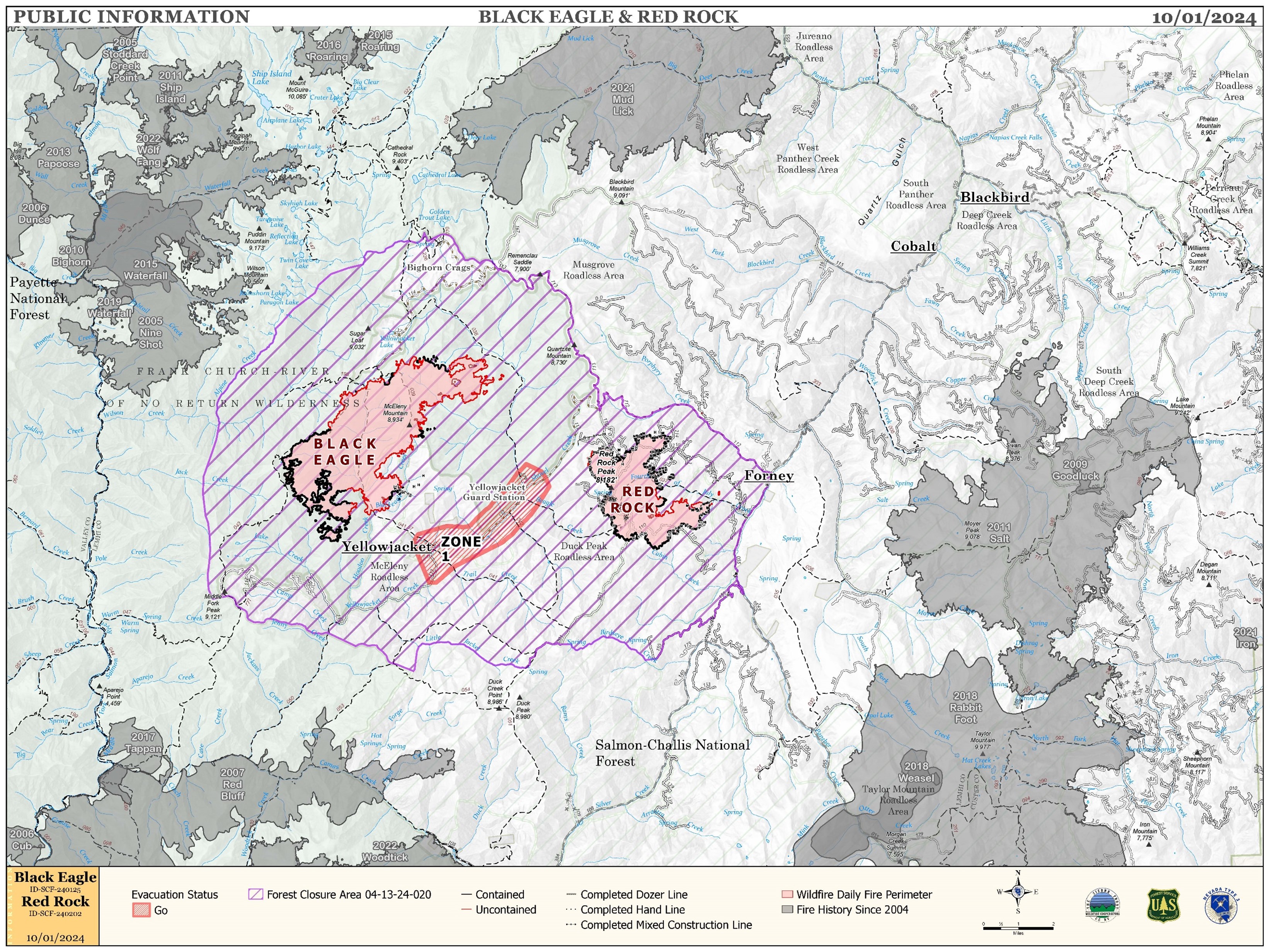
Red Rock and Black Eagle Fire Daily Update 10 01 2024
Related Incident:
Publication Type: News
IRE ACTIVITY:
The Red Rock Fire is at 3,367 acres and 75% containment.
Winds and fire activity moderated overnight with cooler temperatures. The majority of the fire faired very well through Sunday’s high winds; only the northeast side of the fire saw increased growth. The fire burning in the 4th of July drainage still poses control issues due to poor access and unsafe conditions for direct attack. Firefighters are building indirect line ahead of the fire to catch the fire if and when it crosses the drainage.
The Black Eagle Fire is at 7,433 acres and 8% containment.
The Black Eagle Fire saw considerable growth over Sunday’s wind event but nearly all of the added acres were in designated wilderness areas. The division outside of the wilderness is still under a full suppression strategy but areas are also difficult to access safely and indirect attack must be used to control the fire. Aircraft are still supporting both fires with bucket work to slow its progression and cool flare ups to avoid spot fires.
WEATHER:
A weak ridge of high pressure will build over the area today. The winds will remain westerly but increase slightly over yesterday. Much warmer temperatures today with high temperatures 13 degrees warmer than Monday. Slightly higher humidity, but still unseasonably dry for this time of year. A weak system in the north will move through Wednesday bumping winds up slightly. A stronger, but dry, system will move over the area Friday night.
FIRE BEHAVIOR:
Nearly all fuels are available across both fires, though heavy dead and down fuels remain most problematic for firefighters. Areas where humidities fall below 25% with gusty afternoon winds can experience increased activity, including short-range spotting. Opportunities to attack the fire directly will likely be confined to morning hours and when effective water support is available.
FOREST CLOSURES: For forest closure information please go to: https://www.fs.usda.gov/alerts/scnf/alerts-notices
EVACUATIONS: For evacuation information in Lemhi County regarding these fires please go to: Emergency Management Department | Lemhi County, ID (lemhicountyidaho.org).