
Important Elk Fire Information October 2 2024 1100am 10 02 2024
Related Incident: Elk Fire 2024
Publication Type: Announcement
The Sheridan County Sheriff has increased the evacuation status of both the Eagle Ridge Subdivision and the residences directly adjacent to the east of US Highway 14, going up the mountain, to “Set”. If you are in either of these areas, please take the time now to gather up important things and be prepared to evacuate if notified.
The Town of Dayton has been placed in a “Ready” status. If you live in the town of Dayton, take the time now to think about what you would want to take with you or where you might go if the Town of Dayton is put into a “Set” status.
There is an evacuation center being set up at the Sheridan County Fairgrounds at 1753 Victoria St., Sheridan, Wyo. This evacuation center will take large and small animals as well as have the ability to house people. If you have been evacuated, you may bring your camper to the fairgrounds as well. Please ensure you check in with staff upon arrival.
This evening’s community meeting is being moved to the Tongue River Middle School in Ranchester at 1251 Dayton St., Ranchester. Changing location will increase safety for fire responders and local community members in Dayton by decreasing traffic into town.
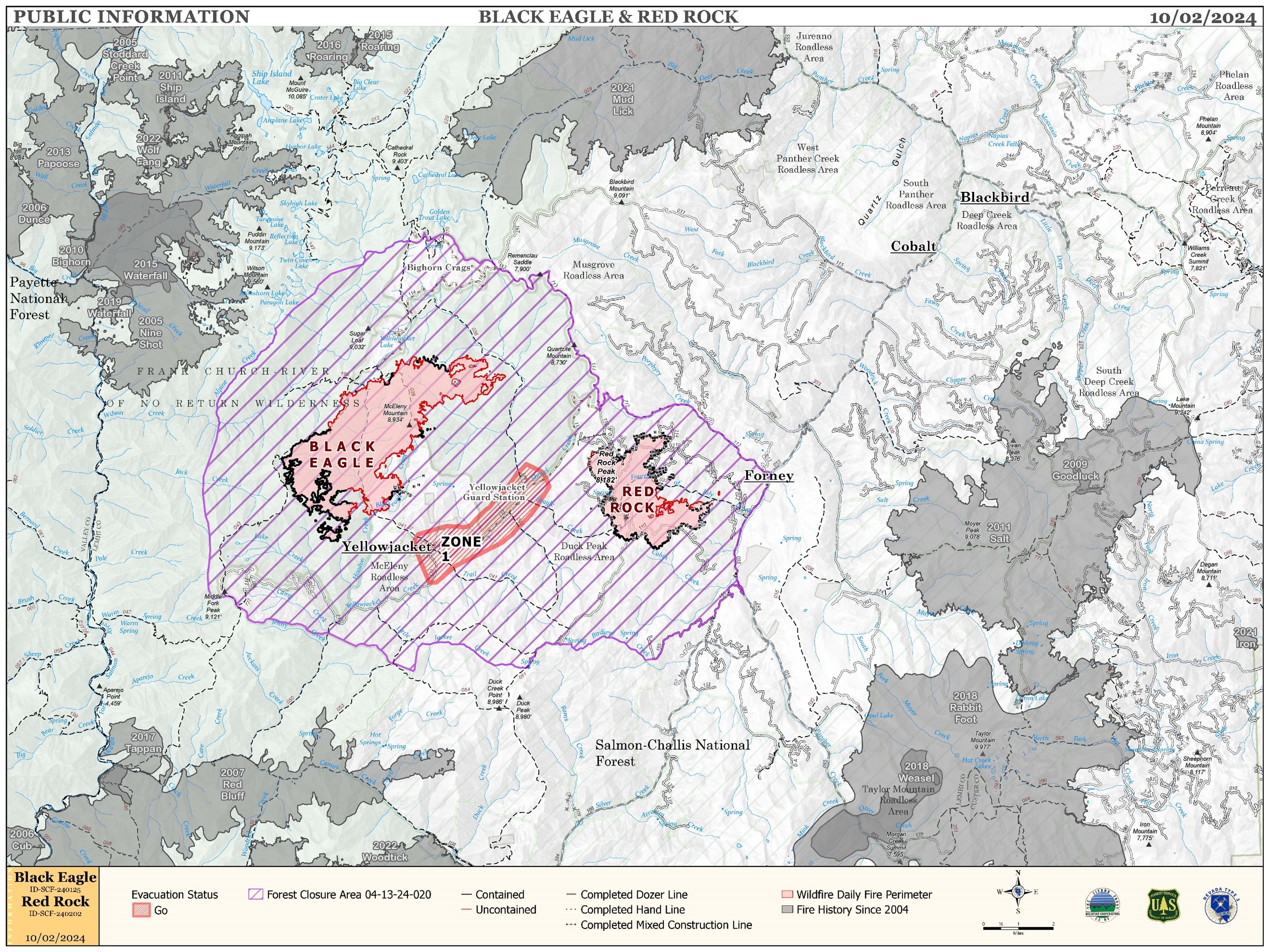
Red Rock and Black Eagle Fires Daily Update 10 02 2024
Related Incident:
Publication Type: News
FIRE ACTIVITY:
The Red Rock Fire is at 3,367 acres and 78% containment.
The slopes above Fourth of July Creek showed some increased activity due to poor overnight humidity recovery and light to moderate winds with gusts into the low 20s.The drainage still poses control issues due to poor access and unsafe conditions for direct attack. Firefighters are building indirect line ahead of the fire to catch it if the fire crosses the drainage. On the north and south sides of the fire, where containment has been established, crews are monitoring fire activity and beginning suppression repair work.
The Black Eagle Fire is at 7,433 acres and 16% containment.
There was a moderate uptick in fire behavior on the Black Eagle Fire as well. Westerly winds were in alignment with west to east drainages and activity was observed in Blackeagle Creek as well as the drainages above Yellowjacket Creek. Use of aircraft was needed to maintain control features.
WEATHER:
The main concern for today is a weak disturbance moving through the ridge currently over the fire area that will bring slightly stronger westerly winds. Conditions continue to be very dry with poor overnight humidity recoveries and minimum afternoon humidity in the mid-teens. Temperatures will remain about eight degrees below normal with highs near 60 and winds will be out of the west 15-17 mph with gusts 23-29 mph. A stronger trough of low pressure will bring stronger winds and unstable conditions to the incident on Friday, but unfortunately looks to be dry.
FIRE BEHAVIOR:
Nearly all fuels are available across both fires, though heavy dead and down fuels remain most problematic for firefighters. Areas where humidities fall below 25% with gusty afternoon winds can experience increased activity, including short-range spotting. Opportunities to attack the fire directly will likely be confined to morning hours and when effective water support is available.
FOREST CLOSURES: For forest closure information please go to: https://www.fs.usda.gov/alerts/scnf/alerts-notices
EVACUATIONS: For evacuation information in Lemhi County regarding these fires please go to: Emergency Management Department | Lemhi County, ID (lemhicountyidaho.org).
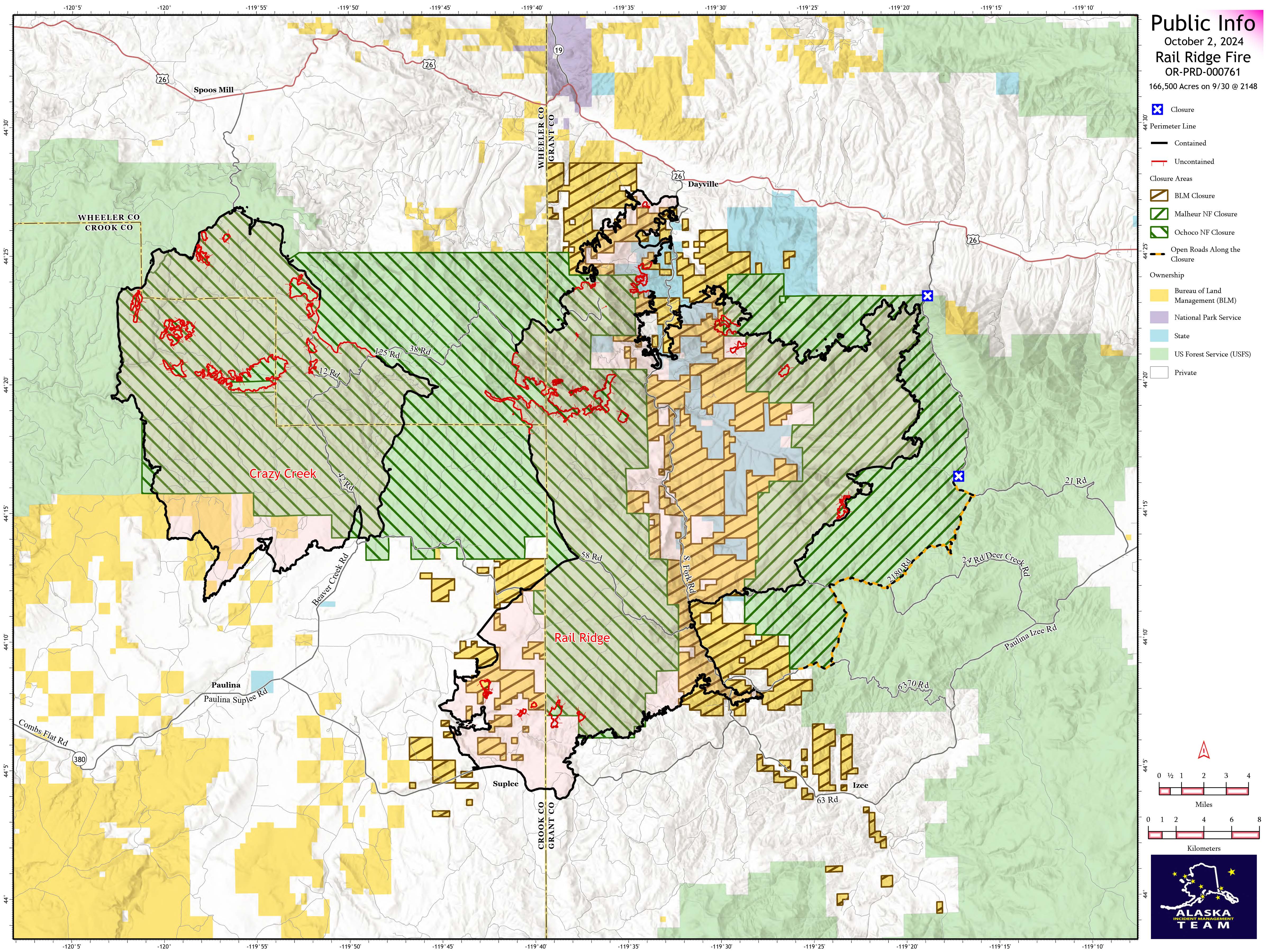
Rail Ridge Daily Fire Update 10 02 2024
Related Incident:
Publication Type: News
Rail Ridge Fire
Acres: 166,500 – Containment: 83% – Detection: 09/02/24 – Cause: Lightning – Personnel: 807
Operational Update
The weather yesterday contributed to an ongoing drying trend, making fuels more available to burn even while temperatures begin to drop. In the Black Canyon Wilderness, the fire advanced up the ridge east of Honeymoon Creek, sending a noticeable smoke plume that was blown back into the fire perimeter with the southwest winds. Black Canyon Creek worked as a slowing point to hold the fire in check. This will be an area of focus today as firefighters strengthen existing lines ahead of winds out of the north that will push the fire southward. Difficult terrain and limited access in the northern half of the fire, along with persistently dry weather and heavy fuel loading will contribute to fire growth in the Black Canyon Wilderness. In the northern divisions, firefighting efforts have added more containment to the fire perimeter in steep and challenging ground. Additional acres of burned area are producing smoke that is visible. In the southern divisions, mop-up is ongoing as crews engage in patrol and repair. Suppression repair will be a key focus on areas of the fire that already show containment.
Weather
A critical dry streak lingers over the fire area again today and the relative humidity will range from 9-14 percent, which is extremely low for this time of year. Light winds out of the north return on Wednesday, bringing near normal temperatures to the region, lowering into the mid-sixties.
Evacuations
Rail Ridge Evacuations: Level 1 and 2 evacuation zones for the Rail Ridge Fire remain in Grant County.
For Current Evacuation Levels all affected counties, please visit: https://linktr.ee/RailRidgeFire
Closures: The U.S. Forest Service and Bureau of Land Management have implemented closures for the Rail Ridge Fire. For more details and closure maps, visit https://linktr.ee/RailRidgeFire

HomesteadDiamond Complexes Daily Fire Update 10 02 2024
Related Incident: Lane 1 Fire
Publication Type: News
Homestead/Diamond Complexes Fire Update
Oct. 2, 2024
Fire Information: 541-208-7100, 8 AM - 8 PM
InciWeb-Homestead: https://t.ly/syeHa and InciWeb-Diamond: https://bit.ly/4gCfLsp
Six fires within the Homestead and Diamond Complexes remain under active management by Northwest Team 12. Firefighting resources from the Homestead/Diamond Complexes remain available for initial attack response to new fire starts in the area as needed.
The Oregon Department of Transportation temporarily lowered the speed limit on Hwy 138 in front of the Fire Incident Command Post just east of Glide to 45 MPH for the safety of firefighters and community residents.
Homestead Complex: 10,258 acres, 35% contained │ Diamond Complex: 11,141 acres, 90% contained │ Total personnel: 397
Very warm temperatures and low humidity in the afternoon produced an increase in fire activity yesterday on the Horse Heaven and Fuller Lake Fires. The warmer and drier weather caused scattered interior smokes to appear across several fires, but these pose no threat to established containment lines.
Fire activity on the Horse Heaven Fire picked up in the afternoon after the inversion lifted. A heavy helicopter dropped several buckets of water on the northwest corner of the fire, successfully limiting fire spread into the Horse Heaven Creek drainage. Mastication work continues on the north side of the fire and grading will resume along Forest Service Road (FSR) 3831. Crews and heavy equipment continue to chip woody debris and engine crews are dismantling and backhauling hose lines that are no longer necessary.
The Fuller Lake Fire became active again this afternoon, producing smoke as it backed into the Boulder Creek Wilderness. Fire crews and equipment completed fire suppression repairs on the eastern side of the fire yesterday, wrapping up final chipping and road repairs. Fire managers continue to monitor fire spread and utilize helicopter water drops as needed to limit fire activity in the southeast corner of the fire. Road work within the Bullpup Fire area continues to progress, with FSR 3850 complete and FSR 300 nearing completion. Firefighters continue to backhaul hose and equipment for return to regional warehouses to be refurbished and made ready for the next fire.
A hot spot was detected on the No Man Fire yesterday, which was determined to be interior and no threat to containment. Crews will continue to patrol and scout for additional smokes. Two fires remain uncontained on the Diamond Complex. On the Potter Fire, crews cut stumps left behind by previous feller buncher operations along FSR 100. Dump trucks continue to haul slash to be chipped near Diamond Lake. Grading along FSR 3704 was completed yesterday and grading along FSR 3703 will begin today. The Pine Bench Fire continues to show no visible smoke.
Closures: The Umpqua National Forest and the Bureau of Land Management (BLM) have revised closure orders. Two closure orders impact the Umpqua National Forest https://t.ly/Mvn6G. A BLM Roseburg District closure order remain also remains in place https://t.ly/uWX6l. A Temporary Flight Restriction remains in effect https://bit.ly/3XJL0cD.
Weather: A weak disturbance will move in, bringing cooler weather and higher relative humidity, with temperatures in the low to mid 70s today. By tonight, another ridge of high pressure will move into the region again, with warmer temperatures and very dry conditions both Thursday and Friday.
Goosmus Fire Update 10022024 10 02 2024
Related Incident: Goosmus Fire
Publication Type: News
Yesterday, infrared technology (Palm IR unit) was utilized to search for smoldering material on the south end of the fire. The unit found 3 spots within 50 feet of the line, verifying that the line is becoming secure and containment is increasing. Crews have utilized 7.5 miles of hose and 10 pumps in containment processes around the fire perimeter. Fallers evaluated and fell fire weakened trees along 4th of July Creek Road to help mitigate against trees threatening to fall into the roadway.
Today, Palm IR units will continue to work along the fireline, focusing on the western edge of the fire. Crews continue to search for smoldering material along the fire perimeter. Interior pockets continue to burn and smolder, sometimes increasing to moderate fire behavior that can result in single or small group torching (visible flames and smoke). These areas are being monitored by crews and have not been a threat to containment efforts.
Elk Fire Daily Update Wednesday 10 02 2024
Related Incident: Elk Fire 2024
Publication Type: News
Elk Fire Update - October 2, 2024
Rocky Mountain Area Complex Incident Management Team 3
Casey Cheesbrough, Incident Commander
Date Reported: Friday, September 27, 2024
Cause: Lightning
Size: 32,096
Containment: 0%
Total Personnel: 200
Location: Approximately 6 miles northwest of Dayton, Wyoming
Key Messages: The Sheridan County Sheriff issued additional evacuations overnight of the following areas: Pass Creek Road and Twin Creek Road west of Parkman; Tongue River Canyon west of Dayton, where the pavement turns to dirt.
The town of Parkman and residents north of Parkman, on both the east and west sides of Highway 345, up to the Montana state line are now under a pre-evacuation or "Ready" notice.
There will be a community meeting at 7:00 p.m. tonight at the Tongue River High School in Dayton. This in-person meeting will be recorded and published on the US Forest Service Bighorn National Forest’s Facebook page.
Current Situation: The fire remained active overnight, moving further to the northeast. Today, firefighting operations will focus on direct and indirect strategies. Firefighters will be improving existing roads and fireline on the northeastern eastern, and southeastern portions of the fire area. Fire managers will be scouting for areas to safely put in fireline on the southern area of the fire. Air resources will continue to assist firefighters on the ground as weather allows.
Firefighter and public safety remain the top priority. The tactics used to suppress the fire will be determined by the terrain, fire and weather conditions, and medical response time.
Closures and Evacuations: US Highway 14 remains closed from Dayton to Burgess Junction. For additional road closures, please visit the Sheridan County Emergency Management website at Sheridan County (sheridancountywy.gov).
Those needing a place to take livestock or a place to stay in a camper may evacuate to the Sheridan County Fairgrounds. If you need a place to stay and you are evacuated, please contact Sheridan County Emergency Management. Please contact the Sheridan County Sheriff’s Office at 307-672-3455 or Sheridan County Emergency Management at 307-752-2174 for more information.
A Bighorn National Forest Closure Order is in place for firefighter and public safety. The area closed is the area north of US Highway 14 and east of the border of the Medicine Wheel Ranger District and the Tongue Ranger District.
Weather & Smoke Information: A red flag warning has been issued for today with temperatures expected to be in the low 70s over the fire area with winds shifting from west to northwest in the afternoon and gusting to 25mph. Relative humidity will be around 20%. It is expected that the Elk Fire will continue to put up a smoke column; please check the AirNow website at https://www.airnow.gov/ to monitor smoke movement.
ELK FIRE INFORMATION
Fire Information Phoneline:
307-303-7642 Time: 8:00 a.m. to 8:00 p.m.
Facebook: https://www.facebook.com/bighornnf
Email: 2024.elk@firenet.gov
InciWeb: inciweb.wildfire.gov/incident-information/wybhf-elk-fire-2024
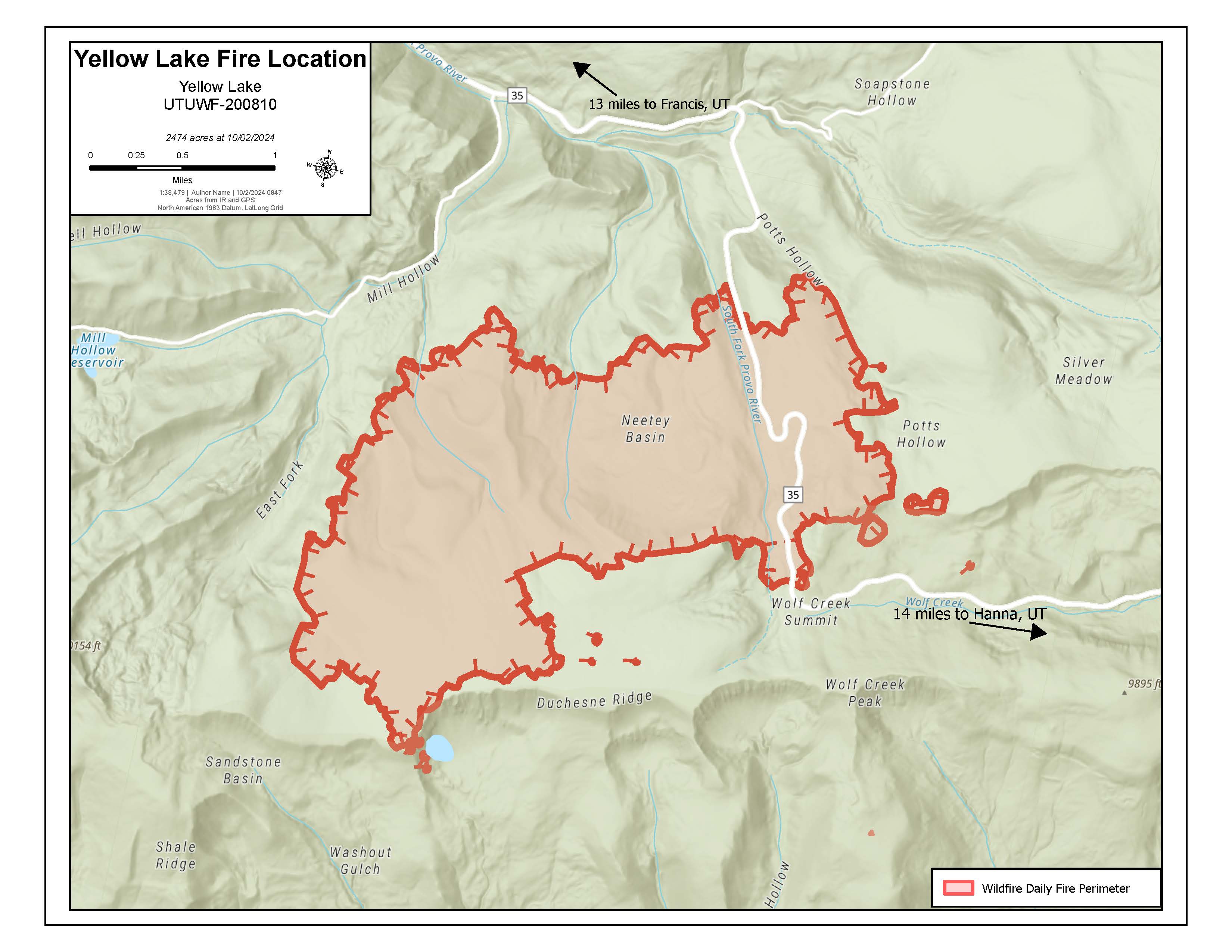
Yellow Lake Fire Update 10 02 2024
Related Incident: Yellow Lake Fire
Publication Type: News
Oct 2, 2024— Fire behavior on the #YellowLakeFire remains active. It is currently at 2,474 acres and still 0% contained.
Northwest winds began to push the fire east/southeast yesterday, causing the fire to spot near Heart Lake. The fire established in a timber stand, increasing fire activity. Firefighters strategically attacked this spot fire, utilizing helicopters with buckets where successful to cool the flames. Campers and recreationists were asked to evacuate the area north of the West Fork of the Duchesne Ridge, and the closure will be extended to include this portion of the Forest.
The fire is still slowly burning through the retardant line on the eastern perimeter. Crews continue to enhance the fuel breaks along the eastern perimeter, as well as near the YMCA camp, by thinning vegetation and utilizing bulldozers. While some of the fire has spotted across these lines, for the most part the current perimeter is not seeing significant growth on the east and west sides. The north side of the fire continues to see activity, though it is currently burning in smaller diameter vegetation and open meadows, slowing progression.
This remains a full suppression fire but with the current conditions and growth, it will likely be a longer duration fire due to the terrain, topography, receptive fuels, and weather. The forecast continues to predict hot, dry, and windy conditions with no moisture predicted. Despite crews making progress, these conditions inhibit containment.
Fire managers are working with their cooperators and respective county and local agencies to coordinate impact on grazing allotments, logging, and other permittee concerns. They are also working with law enforcement to escort recreationists to retrieve their belongings in the campgrounds and in the closure area.
Highway 35 remains closed, for both public and firefighter safety. This closure will remain for at least 24-48 more hours, until fire activity decreases and road conditions can be assessed.
The fire has been determined to be human caused, but it is still under investigation. More information will be released once the final investigation report has been finalized.
The Yellow Lake Fire is located east of Mill Hollow Reservoir on the Uinta-Wasatch-Cache National Forest. Currently, there are 390 personnel assigned to the fire, including ground crews, aircraft, engines, water tenders, and bulldozers.
Morning Update Frog Fire Wednesday 10 02 2024
Related Incident: Frog
Publication Type: News
Frog Fire Statistics
- Size: 3,114 acres
- Containment: 77%
- Total Personnel: 46
- Location: east of Clayton, ID
- Reported: September 7, 2024
- Cause: Lightning
For More Information
InciWeb: https://inciweb.wildfire.gov/incident-information/idstf-frog
Facebook: https://www.facebook.com/sawtoothnationalforest
Current Situation: Another day of steady progress was made on the Frog Fire; containment increased to 77 percent. Firefighters worked on securing existing containment lines and extinguishing any remaining heat on the southeast portion of the fire. Resources will continue to be pulled from the Frog Fire as managers right-size the incident to the appropriate number of personnel for the remaining work to be done. Today, firefighters will keep an eye out for any increased activity and remain on standby to respond appropriately.
A single burning tree was discovered northwest of the Frog Fire yesterday. Crews were able to drop water via helicopter and dig line around the small fire. It was also surrounded by retardant from a past aircraft drop so fire managers feel confident it was from the more active burning days of the Frog Fire and see no significant threat to containment. It serves as a reminder to the fire crews to remain attentive to the whole fire area.
Evacuations: There are currently no evacuations related to the Frog Fire.
Closures: The area closure in place around the Frog Fire includes FS 667 (Big Boulder Creek Road) and Trail 047 where adjacent to the closure boundary. The closure excludes FS Roads 669 and 670 and Trail 682. Hunters and recreationalists should familiarize themselves with this closure information prior to entering the vicinity. Please reference the map and read the full closure description at https://inciweb.wildfire.gov/incident-closures/idstf-frog. Fire managers and local forest officials are evaluating the current closure area for a reduction in size once it is safe to do so.
Morning Update Wapiti Fire Wednesday 10 02 2024
Related Incident:
Publication Type: News
Wapiti Fire Statistics
- Size: 125,758 acres
- Completion: 78%
- Total Personnel: 310
- Location: near Grandjean, ID
- Reported: July 24, 2024
- Cause: Lightning
For More Information
InciWeb: https://inciweb.wildfire.gov/incident-information/idbof-wapiti-fire
Facebook: https://www.facebook.com/wapitifireinfo2024
Linktree: https://linktr.ee/WapitiFireInfo2024
Interactive Map: https://tinyurl.com/WapitiFireInfoMap
Special Emphasis: Collection of firewood within the closure areas is prohibited; any firewood collection in open areas must be done with a valid firewood permit. For questions on firewood collection on the Sawtooth National Forest, please contact the Stanley Ranger Station at 208.774.3000.
Weather: Dry and warm conditions will continue today with winds picking up in the early morning and dropping off in the mid-afternoon. The possibility of precipitation in the near future remains very low.
Current Situation: Crews on the Wapiti Fire worked hard to increase containment yesterday. Due to yesterday’s northwest winds, there was increased fire activity and smoke in Big Meadows blown towards the fire’s interior. Increased smoke was also seen below Copper Mountain and west of Bull Trout Lake. Hand crews and engines continued extinguishing any heat and securing line along the west portion of the fire. The successive warm and dry days have caused interior fuels to be consumed continuously and crews will pay close attention today as fire activity may again increase due to wind, especially around the south edge and the interior.
More hazard tree assessment of Grandjean was completed yesterday to remove standing trees with a high likelihood of falling. The trees were cut down then sawed into firewood-sized pieces. Stream diversion work will continue today. Crews will continue to cut down and clear out hazard trees along several roads in the closure area to ensure safe travel once they reopen to the public.
As a reminder, maps for the Wapiti Fire have been updated to better reflect the difference between containment lines and completion lines, since both strategies are in use on the fire area. Containment will continue to be shown as a black line along the fire perimeter; confinement will be shown as a brown line adjacent to the fire perimeter line.
Evacuations: Evacuation status for Stanley Zone 1 is currently at READY. All residents should remain alert for any change in conditions that may reinitiate an evacuation status. Sign up for Custer County CodeRED emergency notifications: text CUSTER to 99411 or enroll at https://public.coderedweb.com/CNE/BF28E45537FF. Sign up for Boise County Alert Sense emergency notifications at https://public.alertsense.com/SignUp/publicUser.aspx?regionid=1163.
For evacuation information on the Wapiti Fire, please see the Custer County Sheriff’s Facebook page, https://www.facebook.com/p/Custer-County-Sheriff-Idaho-61558947312289/, and the Boise County Sheriff’s Facebook page, https://www.facebook.com/boisecountysheriff/
Closures: The Wapiti Fire area closure covers portions of the Sawtooth, Boise, and Salmon-Challis National Forests. Please reference the map and description at https://inciweb.wildfire.gov/incident- closures/idbof-wapiti-fire. Recreationalists and hunters should reference this map and obey all posted signage regarding the closure area and any related road, trail, and campground closures. Fire managers and local forest officials are evaluating the current closure area for a reduction in size and scope once it is safe to do so.
An interactive map for all closures on the Boise National Forest is found at https://experience.arcgis.com/experience/642380b0eb124c8cab6bd9ad3d7146ad/page/Overview/# data_s=id%3AdataSource_5-1888bd00a2c-layer-13-1888bd00b53-layer-16%3A82