
ATTENTION Evacuation Status UPGRADED for Fremont County Wyoming 09 29 2024
Related Incident:
Publication Type: Announcement
Fremont County Emergency Management has just issued the "SET" Level 2 evacuation status for the following communities: Brooks Lake Lodge, Brooks Lake Road, East & West Pinnacle Drive, Breccia Drive, US HWY 26, entrance to Brooks Lake Road, Falls Campground, Lava Mountain Lodge, Roaming River Subdivision, Buckboard Subdivision, Double Bar J Ranch, Lava Creek Ranch, Triangle C Ranch, Long Creek Ranch, Paintbrush & Carriage Drive, Long Creek Subdivision, the old KOA.
READY evacuation status (Level 1) issued for: The Bourbon Subdivision
Settings - change map background and toggle additional layers
Filter - control incident types displayed on map.
Zoom to your location
Reset map zoom and position
Could not determine your location.
Show Legend
 Wildfire
 Prescribed Fire
 Burned Area
Response
Burned Area
Response Other
Other
Fall Fire
Unit Information
Incident Contacts
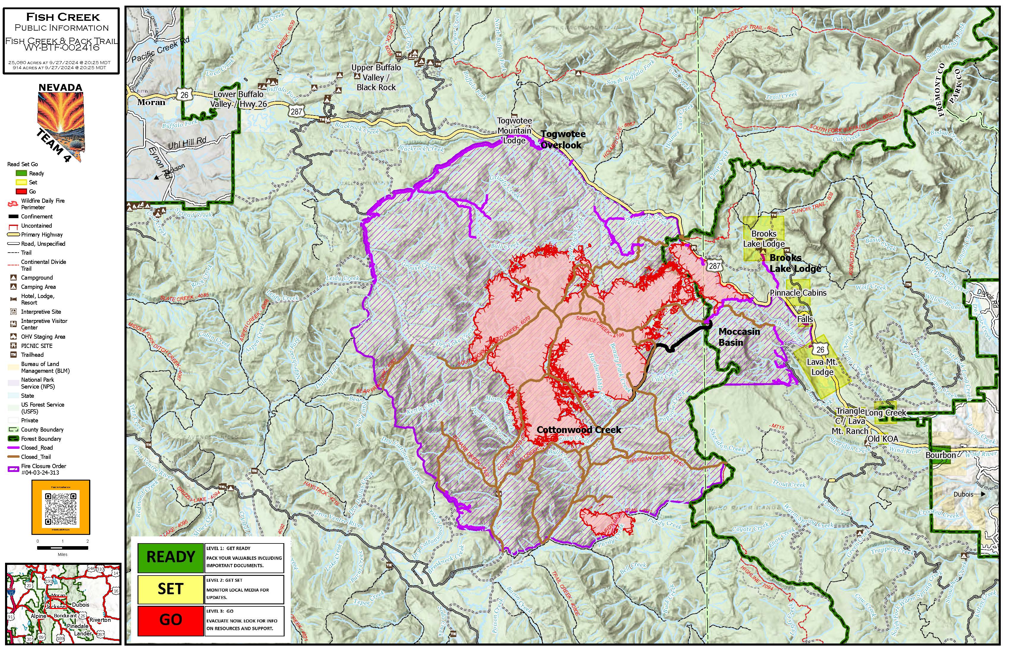
Update Fish Creek Pack Trail Saturday 92824 09 28 2024
Related Incident:
Publication Type: News
Smoke Expected from Fish Creek and Pack Trail Fires through the Weekend
Jackson Wyo., September 28, 2024 –Firefighters remain focused on confining and containing the Fish Creek fire which is 25,069 acres and burning 22-miles southeast of Moran, Wyoming. The fire began on August 16, 2024 and is burning in heavy timber. Despite challenges from strong winds in the past couple of days, the fire stayed within containment lines, although smoke columns have been visible.
Without cooler temperatures, wetting precipitation, or increased humidity, firefighters are not able to count on the weather to aid them in containment efforts. “Even with the rain and snow we saw last week, the fire is established in timber, and although fire activity is diminished, it continues to burn in heavy down and dead fuels,” said Jackson District Ranger Todd Stiles.
Firefighter and public safety is the highest priority for those suppressing the fire. Hazards include exposure to numerous dead and fire-weakened trees (“snags”), which are dangerous to firefighters, particularly during periods with strong, gusty winds.
Road and area closures remain in effect for public and firefighter safety.
The lightning caused Pack Trail fire was identified September 15, 2024, and is 3- miles south of the southern edge of the Fish Creek Fire and is burning in heavy timber and brush just north of the south fork of Purdy Creek. Current fire behavior is active with single and group tree torching with 100% of the fire perimeter active. Hazards include snags, rough terrain, and difficult access. “The fire is surrounded by terrain that is not conducive to expansive spread,” Stiles said. “Should it threaten values in the area management trigger points and action plans have been in place from the onset and will be acted upon”.
Crews will continue to work on suppression repair activities from fireline construction, and work directly along the fire’s edge in the Cottonwood drainage. Currently, are 4 skid steers, 2 excavators, 2 helicopters, 4 fire engines, and 210 personnel to assist with suppression efforts. For information on these fires visit https://inciweb.wildfire.gov/incident-information/wybtf-fish-creek-fire
For other news, events and information you can call 307-739-5500 or visit https://www.fs.usda.gov/btnf or follow the Bridger-Teton National Forest on Facebook @BridgerTetonNF or on X (formerly Twitter) @BridgerTetonNF.
USDA is an equal opportunity provider, employer and lender.
###
Airport Fire Incident Update 09 28 2024
Related Incident:
Publication Type: News
Location: Trabuco Canyon, CA
Personnel: 268
Start date: 09/09/24 1:00 p.m.
Cause: Human
Size: 23,519
Percent contained: 95%
Currently the fire remains within its’ containment lines. Crews continue making progress, to achieve our one hundred percent containment goal, and it is progressing daily. Infrared drones have detected some isolated smoldering heat areas. They are well inside the fire’s perimeter. Crews will be monitoring these areas and cooling them down. Topography and steep terrain have made access of these areas a challenge. Crews are committed to patrolling and monitoring all divisions of the fire, making sure no additional threats remain.
Air resources remain available to provide aerial reconnaissance to crews on the ground. The drones are outfitted with infrared sensors and will continue to be active today, detecting any points of heat that could threaten the containment lines. Dry weather is expected to this week, combined with low humidity.
Fire suppression repair continues along the fire’s perimeter. The Burned Area Emergency Response (BAER) team is assessing the potential for Watershed emergencies that could develop from any change in weather conditions, such as flooding or mudslides. Crew members are working hard to minimize the impacts on the land from the recent activity.
Over the next several days, additional crews will be working in Trabuco Canyon, removing hazardous trees that have been identified by tree experts. These trees have been too severely damaged from the fire and pose a threat if allowed to remain.
Again, we would like to remind everyone that a closure order is in effect for the Trabuco Ranger District of the Cleveland National Forest. Please do not enter the closure area or recreate on any of the firelines constructed for the incident. Please visit this web page for further information. https://www.fs.usda.gov/alerts/cleveland/alerts-notices/?aid=90727
Southern California Edison continues to replace damaged power poles and lines in the Lake
Elsinore area and will be using heavy equipment and helicopters to transport and place these poles. Operations will be scheduled during times of minimal highway use. All motorists should be aware that fire equipment is still working on the roads and traffic delays occur for extended periods. Please plan accordingly.
AIR QUALITY:
Visit AirNow.gov for information and actions you can take to protect yourself and loved ones.
ROAD CLOSURES:
Hard road closures are as follows:
- Trabuco Creek Road
- Maple Springs Road
- North Main Divide Road at Ortega Highway
- Long Canyon Road at Ortega Highway
EVACUATIONS:
All Evacuation orders have been lifted.
CLOSURES:
The Cleveland National Forest has a temporary closure of the Trabuco Ranger District. This closure prohibits going into or, being upon any National Forest System lands, roads, and trails within the boundaries of the Trabuco Ranger District. The closure will be in effect from September 18, 2024 until September 17, 2025, to provide for public health and safety concerns related to the Airport Fire. To view the Forest Orders and Maps, visit our website at: https://www.fs.usda.gov/alerts/cleveland/alerts-notices/?aid=90727 .
FIRE RESTRICTIONS:
There is a Temporary Flight Restriction in effect. Updates on the locations and status of this TFR can be accessed at https://tfr.faa.gov/tfr2/list.html.
Red Fire Daily Update for Saturday 09 28 2024
Related Incident: Red Fire
Publication Type: News
Willamette Complex South & Red Fire Update
Red, 208, Moss Mountain, Coffee Pot, Tire Mountain, McKinley Creek and Chalk Fires
Date: Saturday, September 28, 2024
Fire Causes: Lightning
Email: 2024.willamettecomplex@firenet.gov
Information Phone Line: 541-208-1742
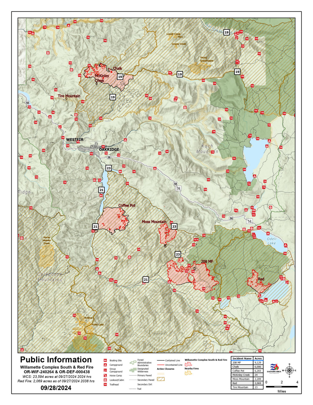
Willamette Complex South: Total Personnel:491| Total Willamette Complex South Acres: 23,564
InciWeb: https://inciweb.wildfire.gov/incident-information/orwif-willamette-complex-fires-south
Facebook: https://www.facebook.com/WillametteComplexFires/
Red Fire: Total Personnel: 73 | Total Red Fire Acres: 2,024
InciWeb: https://inciweb.wildfire.gov/incident-information/ordef-red-fire
Facebook: https://www.facebook.com/2024RedFireOR/
Summary
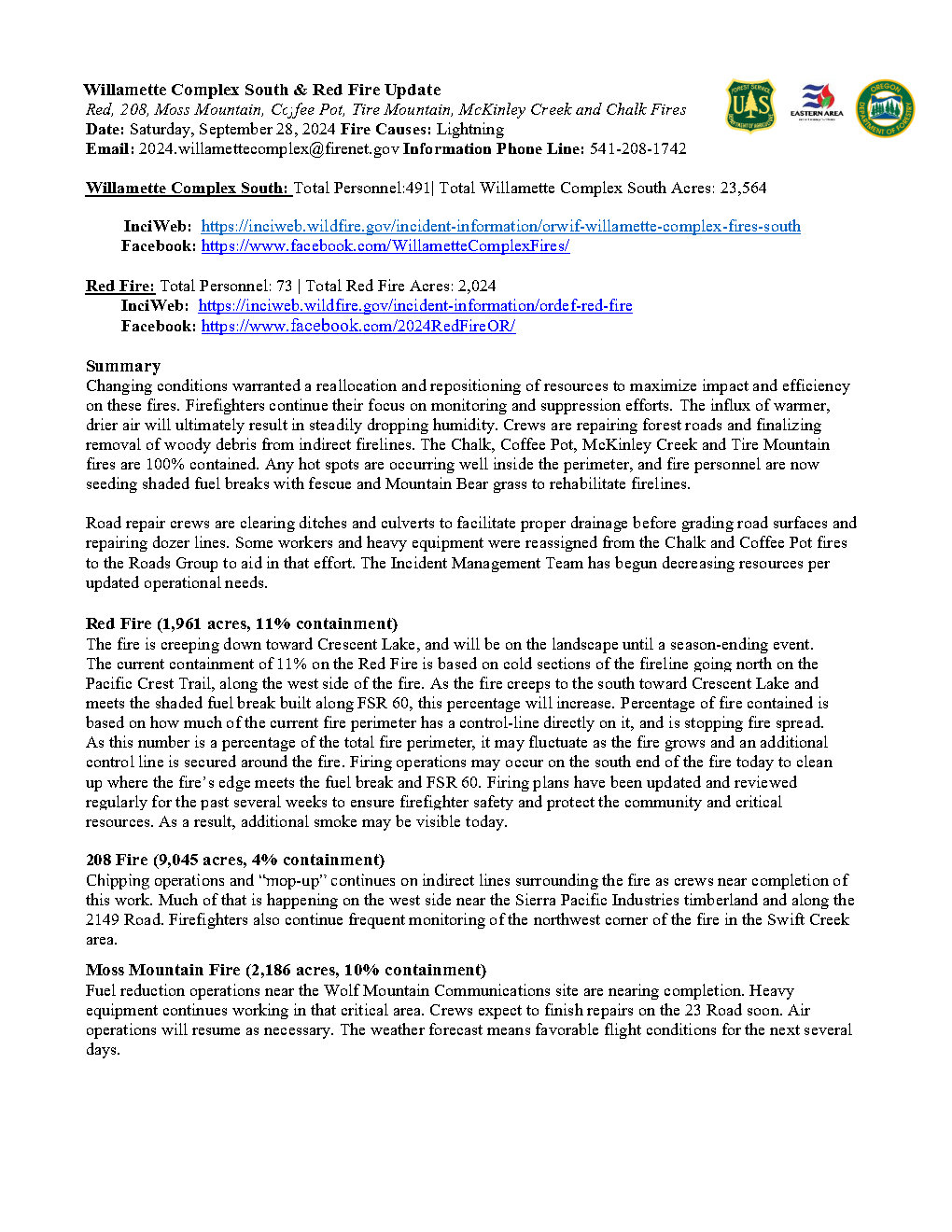
Changing conditions warranted a reallocation and repositioning of resources to maximize impact and efficiency on these fires. Firefighters continue their focus on monitoring and suppression efforts. The influx of warmer, drier air will ultimately result in steadily dropping humidity. Crews are repairing forest roads and finalizing removal of woody debris from indirect firelines. The Chalk, Coffee Pot, McKinley Creek and Tire Mountain fires are 100% contained. Any hot spots are occurring well inside the perimeter, and fire personnel are now seeding shaded fuel breaks with fescue and Mountain Bear grass to rehabilitate firelines.
Road repair crews are clearing ditches and culverts to facilitate proper drainage before grading road surfaces and repairing dozer lines. Some workers and heavy equipment were reassigned from the Chalk and Coffee Pot fires to the Roads Group to aid in that effort. The Incident Management Team has begun decreasing resources per updated operational needs.
Red Fire (1,961 acres, 11% containment)
The fire is creeping down toward Crescent Lake, and will be on the landscape until a season-ending event. The current containment of 11% on the Red Fire is based on cold sections of the fireline going north on the Pacific Crest Trail, along the west side of the fire. As the fire creeps to the south toward Crescent Lake and meets the shaded fuel break built along FSR 60, this percentage will increase. Percentage of fire contained is based on how much of the current fire perimeter has a control-line directly on it, and is stopping fire spread. As this number is a percentage of the total fire perimeter, it may fluctuate as the fire grows and an additional control line is secured around the fire. Firing operations may occur on the south end of the fire today to clean up where the fire’s edge meets the fuel break and FSR 60. Firing plans have been updated and reviewed regularly for the past several weeks to ensure firefighter safety and protect the community and critical resources. As a result, additional smoke may be visible today.
208 Fire (9,045 acres, 4% containment)
Chipping operations and “mop-up” continues on indirect lines surrounding the fire as crews near completion of this work. Much of that is happening on the west side near the Sierra Pacific Industries timberland and along the 2149 Road. Firefighters also continue frequent monitoring of the northwest corner of the fire in the Swift Creek area.
Moss Mountain Fire (2,186 acres, 10% containment)
Fuel reduction operations near the Wolf Mountain Communications site are nearing completion. Heavy equipment continues working in that critical area. Crews expect to finish repairs on the 23 Road soon. Air operations will resume as necessary. The weather forecast means favorable flight conditions for the next several days.
Weather and Fire Behavior
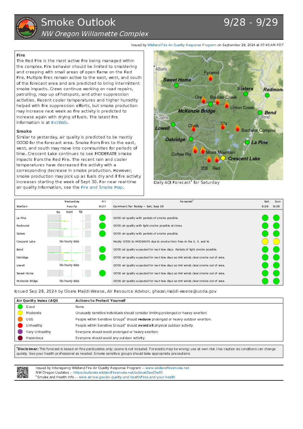
Milder, fall-like conditions are expected for the next several days. Temperatures are predicted to reach the upper-60s to low-70, as much as ten degrees above the seasonal average. The air will give way to increasingly dry, and the relative humidity will likely drop to 40% or less, perhaps as low as 30% in the early part of next week. Lower relative humidity could result in a change in fire behavior.
Closures, Fire Restrictions, and Evacuation
For closure information, visit: https://tinyurl.com/RedFireClosures2024 &
https://tinyurl.com/WillFireClosures2024.
For fire restrictions, visit: https://tinyurl.com/DesFireRestrictions2024 https://tinyurl.com/WillFireRestrictions2024.
The Level 1 – BE READY to Evacuate notice remains in effect for the Red Fire. For more information or to sign up for alerts, visit: www.klamathcounty.org/300/emergency-management.
Willamette Complex South Daily Update for Saturday 09 28 2024
Related Incident: Willamette Complex Fires - South
Publication Type: News
Willamette Complex South & Red Fire Update
Red, 208, Moss Mountain, Coffee Pot, Tire Mountain, McKinley Creek and Chalk Fires
Date: Saturday, September 28, 2024
Fire Causes: Lightning
Email: 2024.willamettecomplex@firenet.gov
Information Phone Line: 541-208-1742
Willamette Complex South: Total Personnel:491| Total Willamette Complex South Acres: 23,564
InciWeb: https://inciweb.wildfire.gov/incident-information/orwif-willamette-complex-fires-south
Facebook: https://www.facebook.com/WillametteComplexFires/
Red Fire: Total Personnel: 73 | Total Red Fire Acres: 2,024
InciWeb: https://inciweb.wildfire.gov/incident-information/ordef-red-fire
Facebook: https://www.facebook.com/2024RedFireOR/
Summary
Changing conditions warranted a reallocation and repositioning of resources to maximize impact and efficiency on these fires. Firefighters continue their focus on monitoring and suppression efforts. The influx of warmer, drier air will ultimately result in steadily dropping humidity. Crews are repairing forest roads and finalizing removal of woody debris from indirect firelines. The Chalk, Coffee Pot, McKinley Creek and Tire Mountain fires are 100% contained. Any hot spots are occurring well inside the perimeter, and fire personnel are now seeding shaded fuel breaks with fescue and Mountain Bear grass to rehabilitate firelines.
Road repair crews are clearing ditches and culverts to facilitate proper drainage before grading road surfaces and repairing dozer lines. Some workers and heavy equipment were reassigned from the Chalk and Coffee Pot fires to the Roads Group to aid in that effort. The Incident Management Team has begun decreasing resources per updated operational needs.
Red Fire (1,961 acres, 11% containment)
The fire is creeping down toward Crescent Lake, and will be on the landscape until a season-ending event. The current containment of 11% on the Red Fire is based on cold sections of the fireline going north on the Pacific Crest Trail, along the west side of the fire. As the fire creeps to the south toward Crescent Lake and meets the shaded fuel break built along FSR 60, this percentage will increase. Percentage of fire contained is based on how much of the current fire perimeter has a control-line directly on it, and is stopping fire spread. As this number is a percentage of the total fire perimeter, it may fluctuate as the fire grows and an additional control line is secured around the fire. Firing operations may occur on the south end of the fire today to clean up where the fire’s edge meets the fuel break and FSR 60. Firing plans have been updated and reviewed regularly for the past several weeks to ensure firefighter safety and protect the community and critical resources. As a result, additional smoke may be visible today.
208 Fire (9,045 acres, 4% containment)
Chipping operations and “mop-up” continues on indirect lines surrounding the fire as crews near completion of this work. Much of that is happening on the west side near the Sierra Pacific Industries timberland and along the 2149 Road. Firefighters also continue frequent monitoring of the northwest corner of the fire in the Swift Creek area.
Moss Mountain Fire (2,186 acres, 10% containment)
Fuel reduction operations near the Wolf Mountain Communications site are nearing completion. Heavy equipment continues working in that critical area. Crews expect to finish repairs on the 23 Road soon. Air operations will resume as necessary. The weather forecast means favorable flight conditions for the next several days.
Weather and Fire Behavior
Milder, fall-like conditions are expected for the next several days. Temperatures are predicted to reach the upper-60s to low-70, as much as ten degrees above the seasonal average. The air will give way to increasingly dry, and the relative humidity will likely drop to 40% or less, perhaps as low as 30% in the early part of next week. Lower relative humidity could result in a change in fire behavior.
Closures, Fire Restrictions, and Evacuation
For closure information, visit: https://tinyurl.com/RedFireClosures2024 &
https://tinyurl.com/WillFireClosures2024.
For fire restrictions, visit: https://tinyurl.com/DesFireRestrictions2024 https://tinyurl.com/WillFireRestrictions2024.
The Level 1 – BE READY to Evacuate notice remains in effect for the Red Fire. For more information or to sign up for alerts, visit: www.klamathcounty.org/300/emergency-management.
West Fire Update 09 28 2024
Related Incident: 2024 - West Fire - TNF
Publication Type: News
September 28, 2024
Size: 15,074 acres Start Date: August 28, 2024
Cause: Lightning Location: Payson Ranger District, Arizona
Containment: 65% Fuels: Ponderosa pine, mixed conifer, chaparral
Total personnel: 158
Operations: Yesterday, Gila County Division of Emergency Management lowered evacuation levels around the fire to READY status, meaning be aware of hazards and have a plan in the event of an evacuation order. Crews monitored fire burning in the interior, naturally cleaning up remaining fuel on the ground. Work to return fire equipment and supplies from the line continues and is expected to be complete by September 29. Fire managers met with the Burned Area Emergency Response team members to begin the work of preparing for possible erosion and needed repairs to the fire area. Today, crews will continue to monitor the fire and check for containment; no further ignitions are expected to occur. There will be smoke settling in lower areas overnight with expected light winds over the weekend.
Weather: Today, sunny with haze and smoke in the afternoon, with high temperatures of 89 degrees. Winds SE 5 mph, 0% chance of precipitation, with humidity in the 16% range. Tonight, clear with haze, low around 58 degrees, winds E 5 mph
Safety: The health and safety of firefighters and the public are always a priority. Please remember to respect closure areas and be cautious when driving near fire equipment on the roads.
Smoke: Smoke from the West fire may be visible as interior fuel continues to dry and burn, decreasing as the week wears on. Expect concentrations in low-lying areas near the fire perimeter in the mornings. Smoke-sensitive individuals and people with respiratory problems or heart disease are encouraged to take precautionary measures. Learn more about smoke impacts on the Arizona Department of Environmental Quality website.
Closures: The Tonto National Forest has issued a closure for land surrounding the West fire. This includes the Pine Trailhead. https://inciweb.wildfire.gov/incident-publication/aztnf-2024-west-fire-tnf/us-forest-service-closure-order-for-west-fire-09-04-2024
Evacuations: Pine residents on the east side of SR 87 and east of North Pine Creek Canyon Road are in READY status. Geronimo Estates residents near the West Fire are in READY status. For information on evacuation status, visit https://nifc.maps.arcgis.com/apps/instant/sidebar/index.html?appid=9bf2ca222ee74f8697bc670ae9c2531a To receive emergency notifications from Gila County, visit https://gilacountyaz.genasys.com/portal/en
For the latest news and information about the Tonto National Forest, follow along on Facebook @TontoNationalForest, ‘X’ (formerly Twitter) @TontoForest or Instagram @tontonationalforest and on the Tonto National Forest website: https://www.fs.usda.gov/tonto
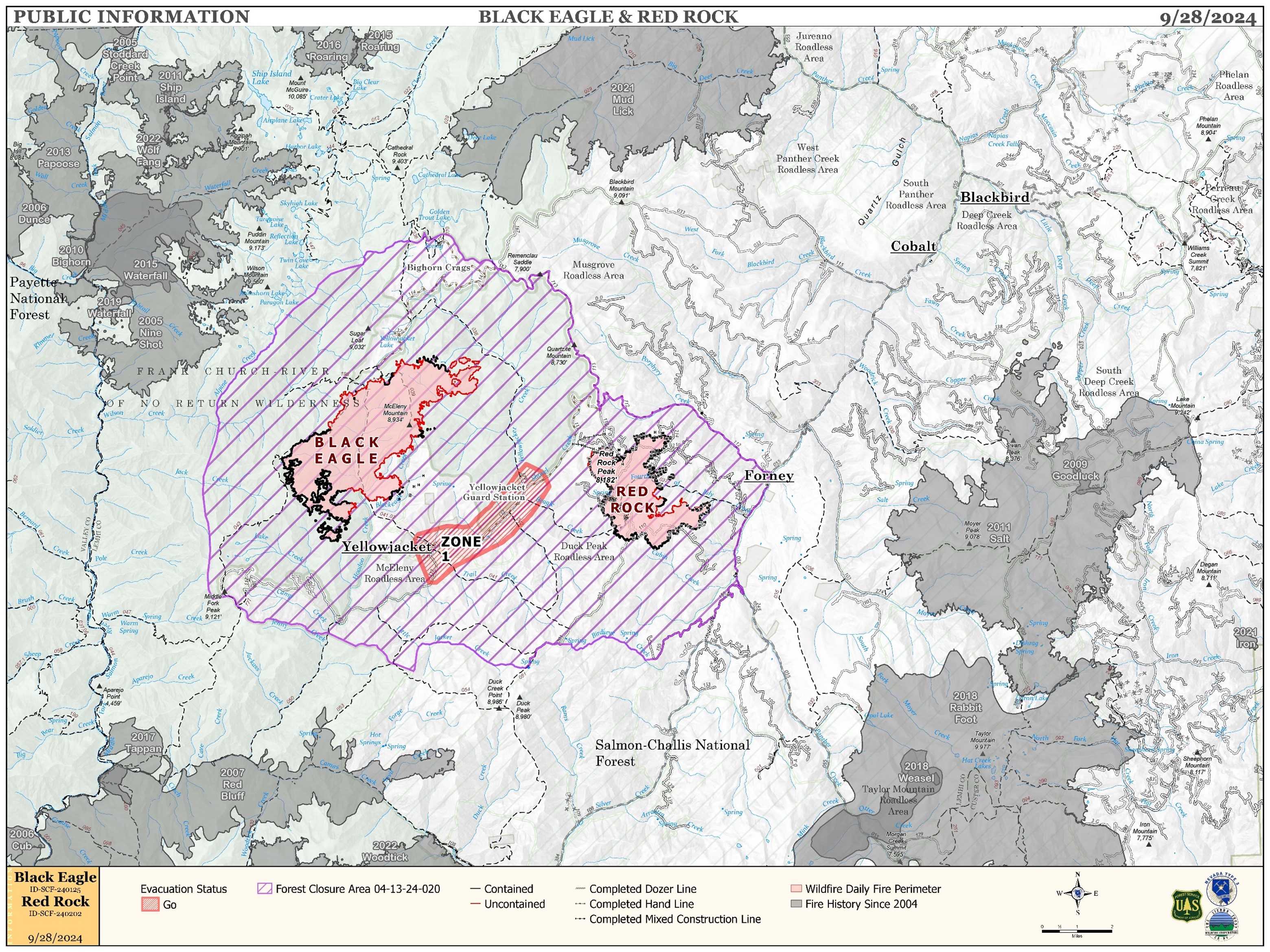
Red Rock and Black Eagle Fire Daily Update 09 28 2024
Related Incident:
Publication Type: News
FIRE WEATHER WATCH ISSUED FOR SUNDAY FOR RED ROCK AND BLACK EAGLE FIRE AREAS
FIRE ACTIVITY:
The Red Rock Fire is at 3,217 acres and 73% containment.
Yesterday’s warmer, drier weather resulted in increased fire activity in areas with heavy dead and down fuels. Aircraft support was used to help maintain control features in areas of increased activity. While the fire added a very few acres, those acres were mostly within the existing fire footprint. Crews continued to focus on improving lines and increasing line depth using a combination of direct, indirect, and point protection tactics.
The Black Eagle Fire is at 6,888 acres and 8% containment.
The Black Eagle Fire added a few acres overnight, primarily in designated wilderness, and crews continue to monitor the fire closely. Like the Red Rock Fire, the Black Eagle Fire saw increased fire activity in areas with heavy dead and down fuels. In areas outside of designated wilderness, aircraft supported ground crew efforts to secure and improve the fireline. Crews are utilizing MIST tactics, including direct and indirect attack, outside of wilderness boundaries.
WEATHER:
A trough of low pressure moves into the Pacific Northwest this weekend, creating unseasonably warm and dry conditions in the fire area. Winds from the west-southwest pick up Saturday afternoon, gusting to nearly 20 mph. The winds will remain gusty overnight, then increase to west-southwest winds up to 15 mph with gusts of 35 mph or higher by Sunday afternoon. Due to the dry, windy conditions, the Incident Meteorologist (IMET) has issued a Fire Weather Watch for Sunday for the Red Rock and Black Eagle fire area.
FIRE BEHAVIOR:
Moderate overnight humidity recoveries moderated fire behavior somewhat across both fires. Areas where humidities fall below 25% with gusty afternoon winds can experience increased activity in heavy dead and down fuels, including short-range spotting. Controlling spot fires and direct line construction in these areas will be the most difficult for firefighters.
FOREST CLOSURES: For forest closure information please go to: https://www.fs.usda.gov/alerts/scnf/alerts-notices
EVACUATIONS: For evacuation information in Lemhi County regarding these fires please go to: Emergency Management Department | Lemhi County, ID (lemhicountyidaho.org).
Rail Ridge and Wiley Flat Fire Daily Update 09 28 2024
Related Incident:
Publication Type: News
Rail Ridge Fire
Acres: 165,586 – Containment: 74% – Detection Date: Sept 2, 2024 – Cause: Lightning – Total resources: 1,189
Operational Update:
Yesterday, warmer and dryer conditions contributed to a small increase in acreage on the Rail Ridge Fire. The fire has crossed Black Canyon Creek and is estimated to have consumed approximately 150 acres on the south side of the creek. Smoke was observed in the headwaters of Black Canyon Creek yesterday, which provided a barrier for direct sunlight, moderating fire behavior. A possible increase in fire activity is expected today with warmer temperatures and forecasted winds gusting up to 25MPH. The fire continued to back and flank west along Coffee Pot Ridge. Firefighters used strategic application of fire to bring the fire edges together to create black line. These firing operations were supported by helicopters that provided water bucket drops to hotshot crews working on the ground. As days get shorter, shading in the canyon creates a shorter burn window when the fire is influenced by direct sunlight. Firefighters will continue to hotspot, cold trail, and mop up areas of heat in the northwestern portion of the fire in the Black Canyon Wilderness as well as the northeast side, where they continue to gain containment, and shift into suppression repair work.
Wiley Flat Fire
Acres: 30,186 – Containment: 94% – Detection Date: Sept 2, 2024 – Cause: Lightning – Total resources: 49
Operational Update: Suppression repair efforts will continue today as fire crews work towards full containment.
Weather
Gusty winds are expected today across the fire area, transitioning from the south to the southwest, and northwest on the ridges. Gusts up to 20-25MPH with lower humidities and temperatures in the mid 80’s.
Evacuations
Rail Ridge Evacuations: Level 1 and 2 evacuation zones for the Rail Ridge Fire remain in Grant County.
Wiley Flat Evacuations: Level 2 and 3 evacuation zones are in place for the Wiley Flat Fire in Crook County.
For Current Evacuation Levels in Wheeler, Crook and Grant counties, please visit: https://linktr.ee/RailRidgeFire
Closures
The U.S. Forest Service and Bureau of Land Management have implemented closures for the Rail Ridge and Wiley Flat Fires. For more details and closure maps, visit https://linktr.ee/RailRidgeFire
The referenced media source is missing and needs to be re-embedded.
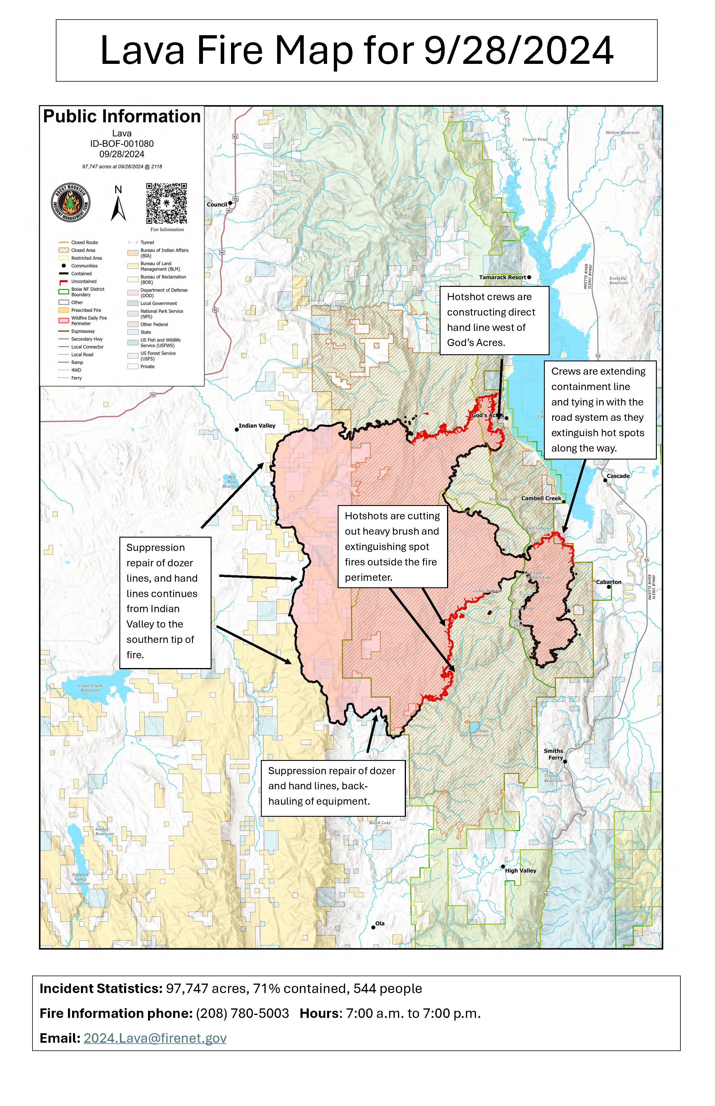
Daily Update 092824 09 28 2024
Related Incident:
Publication Type: News
Current Situation:
- The Lava Fire is 71% contained at 97,747 acres, with 544 personnel assigned.
- On the east side of the fire, Idaho City Hotshots constructed hand line from Snowbank Mountain to Gabes Peak. Smokes were visible in the area. Helicopters delivered 55,000 gallons of water to firefighters there. Work here is expected to take several days to contain the fire’s edge.
- The Kern Hotshots scouted southeast fire’s edge south of Gabes Peak to the Second Fork of Squaw Creek yesterday along the 653 Road. They will work on cutting brush and extinguishing hot spots along the fire edge to secure the line.
- Hotshot crews will be constructing handline directly along the fire’s perimeter west of God’s Acre.
- The spot fires discovered outside the fire’s northeast perimeter were controlled yesterday.
- As containment is established, crews are repairing damage from suppression activities and are back hauling the equipment that is no longer needed.
Weather: Warmer weather was prevalent over the fire area yesterday and today’s weather is expected to be somewhat warmer and dryer today, with possibly record setting temperatures on Saturday.
Evacuations: A Level 1 “READY” notice remains for residents south of South Grays Creek, along Little Weiser River Road in Indian Valley, North of South Grays Creek Road to Highway 95, and the Mesa Area. Valley County Sheriff’s Office has removed Zones 2 & 3 from LEVEL 1 “READY” status. Zones 4 – 6 remain in a LEVEL 1 “READY” Evacuation notice.
Closures: Closures: The Boise and Payette National Forests implemented a joint Lava Fire Area, Road, and Trail Closure for public and firefighter safety. For more closure information see the Payette National Forest website: https://www.fs.usda.gov/alerts/payette/alerts-notices or the Boise National Forest website: https://www.fs.usda.gov/alerts/boise/alerts-notices.
Gem County Road and Bridge issued the following road closures: Third Fork Road at Nesbitt Lane, Second Fork Road at Nesbitt Lane, and Nesbitt Lane. The Sweet-Ola Highway is closed at the High Valley intersection in Ola.
Temporary Flight Restrictions: A temporary flight restriction (TFR) has been updated. View a map of the TFR and details at https://tfr.faa.gov/save_pages/detail_4_8199.html. Fire aviation response is halted or delayed if an unauthorized aircraft enters the TFR. Temporary flight restrictions also apply to unmanned aircraft systems or drones. If you fly, we can’t! Learn more about how to use drones safely and responsibly at Home - Know Before You Fly.
Fire Info Phone: 208-708-5003 Hours: 7:00 a.m. to 7:00 p.m. Email: 2024.Lava@firenet.gov .
Facebook:@LavaFire Inciweb: inciweb.wildfire.gov/incident-information/idbof-lava-fire