
Daily Fish Creek and Pack Trail Fire Updates for Sunday 09 29 2024
Related Incident:
Publication Type: News
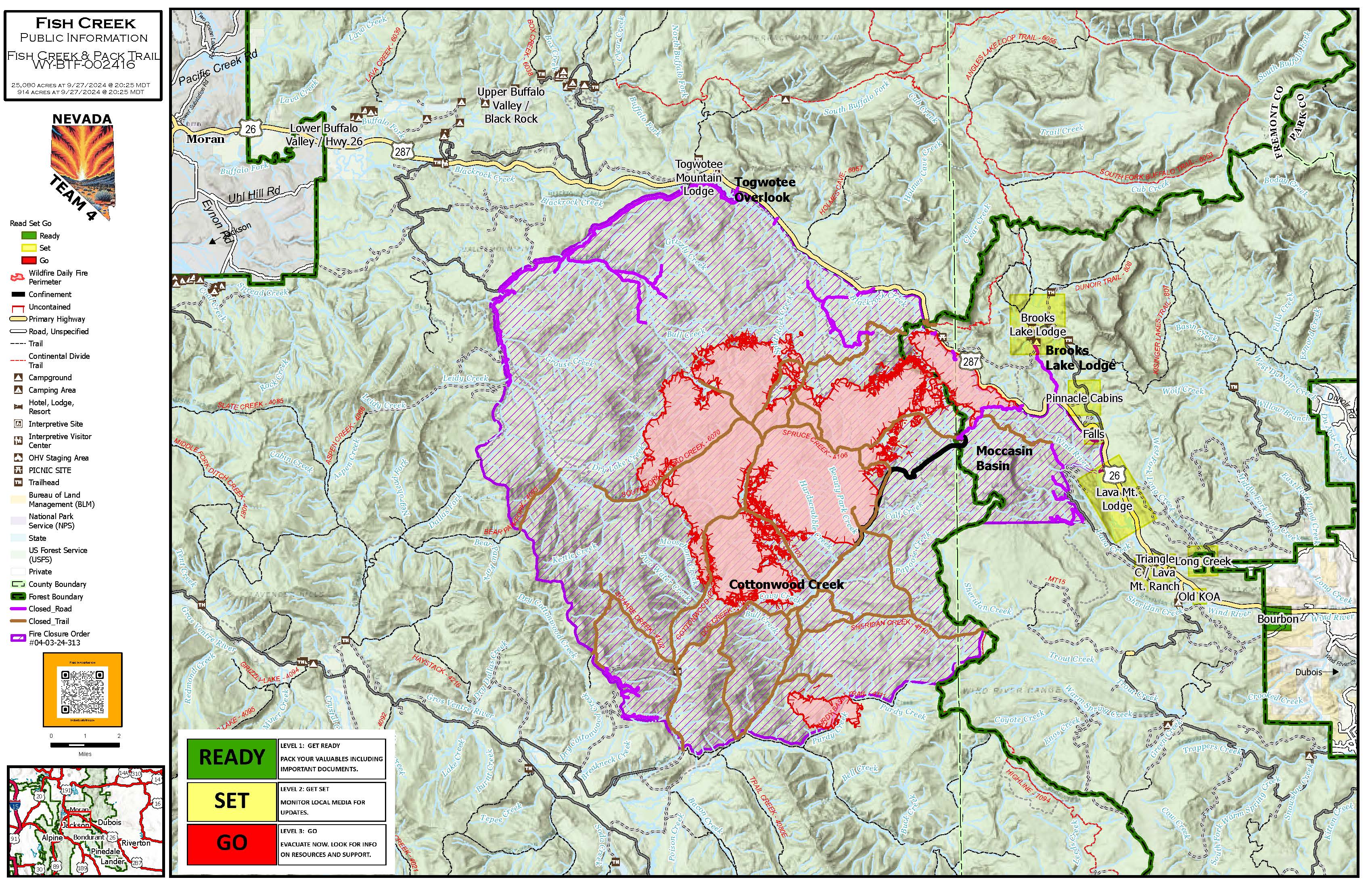
Jackson Wyo., September 29, 2024 – The Fish Creek Fire and the Pack Trail Fire were extremely visible on Saturday, September 28, putting large smoke columns into the air. The Fish Creek Fire acreage is 25,069 acres and the Pack Trail fire, just 3 miles south of the southern edge of the Fish Creek Fire, grew to over 9,000 acres. Both fires are burning in heavy timber. The lightning-caused Fish Creek Fire was discovered on August 16, 2024, while the lightning caused Pack Trail Fire was discovered on September 15, 2024. There is an emergency closure in effect around both fires.
An Incident Management Team has been suppressing these fires. While both fires have been active and creating smoke columns, the Pack Trail Fire growth was significant yesterday. “The fire is in remote terrain with very difficult access,” said Jackson District Ranger Todd Stiles. “Tree density and heavy dead and snag tree components make it very dangerous to put firefighters on the ground,” he said. Firefighter safety has remained the number one priority throughout this incident. “After initial attempts to access the Pack Trail Fire by our local helitack firefighters, it was determined that attempts to put a larger force on the ground would likely be unsuccessful, and could result in high likelihood of injury,” he said. Early attempts to tamp the Pack Trail Fire down with air resources and water drops had no effect. The weather that day was extremely windy, contributing to the overall ineffectiveness of aerial attack.
A confinement and point protection strategy was orchestrated by the Incident Management Team and firefighters to utilize the surrounding terrain and changes in fuel type to act as potential containment features. “Weather and forecasted precipitation have not materialized over the fire,” Stiles continued. "Substantial air resources have been applied by the Incident Management Team, and with yesterday’s dry and warm conditions, air attack efforts had little effect. “The fire started to spotting ahead of itself, passing over and even burning through the terrain and more favorable grass and sage fuel type confinement features,” Stiles said. “The fire displayed behavior much more indicative of mid to late August prime summer fire season,” he noted.
Additional resources are on order and this fire is now the priority fire in the region.
EVACUATION INFORMATION:
Fremont County Emergency Management issued the "SET" Level 2 evacuation status for the following communities: Brooks Lake Lodge, Brooks Lake Road, East & West Pinnacle Drive, Breccia Drive, US HWY 26, entrance to Brooks Lake Road, Falls Campground, Lava Mountain Lodge, Roaming River Subdivision, Buckboard Subdivision, Double Bar J Ranch, Lava Creek Ranch, Triangle C Ranch, Long Creek Ranch, Paintbrush & Carriage Drive, Long Creek Subdivision, the old KOA.
READY evacuation status (Level 1) issued for: The Bourbon Subdivision
Visit the incident information pages for the latest information:
- https://inciweb.wildfire.gov/incident-information/wybtf-pack-trail-fire
- https://inciweb.wildfire.gov/incident-information/wybtf-fish-creek-fire
The emergency closure order is in effect and can be found at https://www.fs.usda.gov/Internet/FSE_DOCUMENTS/fseprd1205718.pdf
The map of the emergency closure is located at: https://www.fs.usda.gov/Internet/FSE_DOCUMENTS/fseprd1205717.pdf
For weather forecast visit: https://forecast.weather.gov/MapClick.php?CityName=Riverton&state=WY&site=RIW&textField1=43.0356&textField2=-108.415&e=0
For up to date road closure and Highway 26/287 information, visit: https://www.wyoroad.info/511/511announcement.html
Please direct all public or media inquiries to Public Information at 2024.fishcreek@fienet.gov or by phone at 307-395-2351.
For other news, events and information, please call 307-739-5500 or visit https://www.fs.usda.gov/btnf or follow the Bridger-Teton National Forest on Facebook @BridgerTetonNF or on X (formerly Twitter) @BridgerTetonNF.
USDA is an equal opportunity provider, employer and lender.
###
Level 123 Ready Set GO Evacuation status explained 09 29 2024
Related Incident:
Publication Type: News
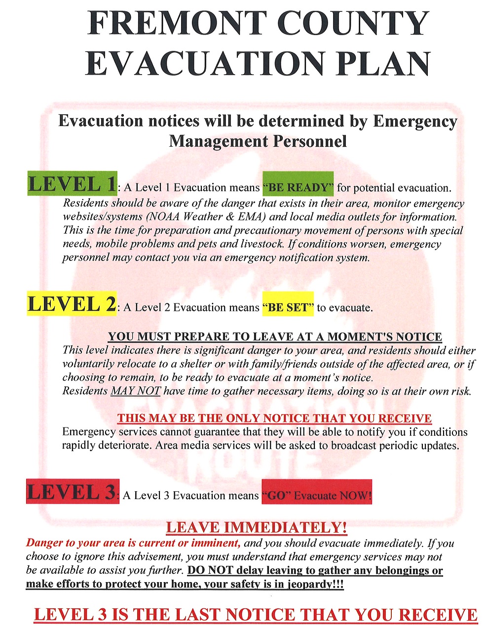
Due to increased wildfire threats in the area, Fremont County Wyoming, in coordination with the Incident Management Team has issued "SET" (Level 2) and "READY" (Level 1) evacuation alerts. This is part of the Ready, Set, Go alert system that helps residents to know how to prepare and when to act in the face of an impending wildfire.
READY status is the earliest in the warning levels, and also known as Level 1. This is when residents should sign up for local emergency alerts, and put together your personal or family emergency plan and emergency supply kit for each person in your household. Residents should also gather financial and critical personal, household, and medical information. Give your household the best chance of surviving a wildfire by being ready to go and evacuating early. Being ready to go also means knowing when to evacuate and what to do if you become trapped.
If you are placed into the SET status, or Level 2, there are things you should do both inside and outside your home, as well as preparations for your animals.
Inside the house, residents should pack a ‘Go Bag’ or have the Emergency Kit, ready to grab by the door. All residents should know your community’s emergency plan, evacuation routes, and destinations as signs may be obscured by smoke or darkness or unpassable due to fallen trees and debris.
Close all windows and doors but leave them unlocked. Take down flammable window treatments like shades and curtains, and close metal shutters. Clear away light curtains. Move anything that burns easily to the middle of rooms, away from windows and doors. Homeowners should turn off the gas at the meter and all pilot lights. You should leave lights on for firefighters to see your house in smoke.
Outside the house, homeowners should bring in flammable items from outside, like patio furniture, toys, doormats, and trash bins.
Shut off propane tanks, move grills and other propane BBQ appliances away from the house and attach garden hoses to the spigots for firefighters to use. Don’t leave sprinklers or water running as it can lower critical water pressure. Keep exterior lights on to make your home visible in smoky or dark conditions. Put your emergency kit in your car and park your car in the driveway, facing outwards, loaded and ready, with all doors and windows shut. Have a ladder handy for firefighter roof access, and seal attic and ground vents with plywood or commercial seals. Keep an eye on the fire situation and don’t wait for an evacuation order if you feel at risk. Check with neighbors to ensure they’re also prepared.
Also, you need to make preparations for the animals. Keep pets close and ready to go, and plan for farm animal evacuation early, arranging transport and safe locations.
If the GO status, or Level 3 alert is activated, act early!.
By leaving early you give your family the best chance of surviving the incident at hand. This also allows emergency personnel to respond to the incident more effectively and bring it to a resolution more quickly.
Leave early to avoid being caught in the approaching incident or road congestion. Don't wait to be told by officials to leave. IF YOU FEEL YOUR LIFE IS IN DANGER, LEAVE IMMEDIATELY! If you are advised to leave, don't hesitate. Head to your predetermined location or as directed by officials. Have several routes planned in case one route is blocked. Choose an escape route away from the incident. Stay informed on current road status, closures and hazards. Take your emergency supply kit containing your family's & pet's medications & necessary items.
Visit Fremont County's web page for more information on evacuation planning for your residence . https://www.fremontcountywy.org/government/departments/emergency_management/index.php
Rail Ridge and Wiley Flat Fire Daily Update 09 29 2024
Related Incident:
Publication Type: News
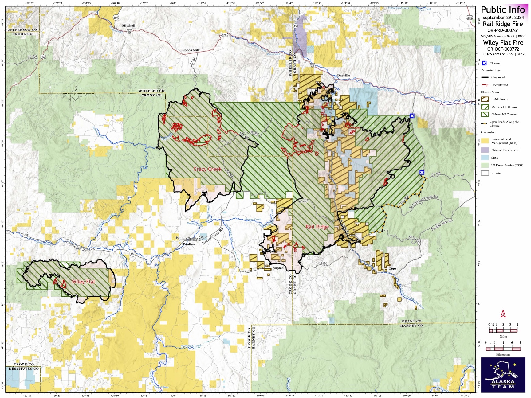
Rail Ridge and Wiley Fire Daily Update
9-29-24
Rail Ridge Fire
Acres: 165,586 – Containment: 80% – Detection Date: 09/02/24 – Cause: Lightning – Total resources: 1,136
Operational Update: Yesterday, hot and dry conditions contributed to an increase in acreage on the Rail Ridge Fire. In the Black Canyon Wilderness, the fire crossed Black Canyon Creek onto the ridge east of Honeymoon Basin and poses new challenges to firefighters. Today’s weather will be much cooler, though winds will be stronger and out of the northwest, and relative humidity will be lower. Weather continues to challenge efforts. In the northern divisions, firefighters continue to mop up and extinguish isolated heat sources and are working toward suppression repair. More fireline has been added to containment. In the southern portion of the fire, patrols continue, and suppression repair is ongoing. Much of the repairs are being made to roads which received heavy impacts during suppression efforts.
Wiley Flat Fire
Acres: 30,186 – Containment: 94% – Detection Date: 09/02/24 – Cause: Lightning – Total resources: 47
Operational Update: Heavy equipment made progress on road repairs and falling teams are taking out hazard trees along road corridors.
Weather
Today’s wind direction will change and come from the northwest. It will be a dry day as relative humidity is expected in the teens. Temperatures will be much cooler, with highs only reaching into the sixties.
Evacuations
Rail Ridge Evacuations: Level 1 and 2 evacuation zones for the Rail Ridge Fire remain in Grant County.
Wiley Flat Evacuations: Level 2 and 3 evacuation zones are in place for the Wiley Flat Fire in Crook County.
For Current Evacuation Levels in Wheeler, Crook and Grant counties, please visit: https://linktr.ee/RailRidgeFire
Closures
The U.S. Forest Service and Bureau of Land Management have implemented closures for the Rail Ridge and Wiley Flat Fires. For more details and closure maps, visit https://linktr.ee/RailRidgeFire
#RailRidgeFire2024 #WileyFlatFire2024 #FireYear2024

HomesteadDiamond Complexes and Lane 1 Daily Fire Update 09 29 2024
Related Incident: Lane 1 Fire
Publication Type: News
Homestead/Diamond Complexes and Lane 1 Fires
Sept. 29, 2024
Fire Information: 541-208-7100, 8 AM - 8 PM
InciWeb-Homestead: https://t.ly/syeHa and InciWeb-Diamond: https://bit.ly/4gCfLsp
Seven fires within the Homestead Complex, Lane 1, and Diamond Complex remain under active management by Northwest Team 12. Firefighting resources from the Homestead Complex remain available for initial attack response to new fire starts in the area as needed.
Homestead Complex: 10,024 acres, 35% contained │ Lane 1: 25,951 acres, 99% contained │ Diamond Complex: 11,141 acres, 90% contained │ Total personnel: 503
Warm and dry conditions contributed to backing fire and visible smoke yesterday. Infrared heat signatures still show scattered heat with smoldering and creeping in available fuels, but this predominantly interior activity poses no threat to the containment of the fires.
Fire managers observed minimal surface spread on the northwest portion of the Horse Heaven Fire, and fire crews are continuing to patrol and mop up as needed. Chipping and mastication were completed along Forest Service Roads (FSR) 3180 and the 100 spur. Tomorrow chipping will begin along FSR 3829 and engine crews will continue to patrol and backhaul hose from areas where it’s no longer needed.
The Fuller Lake Fire continues to produce visible smoke as it backs and creeps into the Boulder Creek Wilderness. Fire managers estimate a few more days to complete chipping of slash along FSR 3810 as well as multiple days of hazardous tree removal work for sawyers. On the Bullpup Fire, numerous roads are still being graded and crews continue to chip piles of woody debris along roads.
The No Man Fire remains in patrol and monitor status presenting no signs of smoke or fire activity. On the Lane 1 Fire, excavators are completing fire suppression repair work in the Fairview area.
Two fires remain uncontained on the Diamond Complex. Chipping continues on the Potter Fire along FSR 100, with chips being hauled away and utilized for ground cover in the Diamond Lake area. Tomorrow, radio technicians will fly in via helicopter to remove radio transmission equipment that is no longer needed from a remote site on Potter Peak. The Pine Bench Fire is wrapping up and showed no visible smoke.
Closures: The Umpqua National Forest and the Bureau of Land Management (BLM) have revised closure orders. Two closure orders impact the Umpqua National Forest https://t.ly/Mvn6G. A BLM Roseburg District closure order remain also remains in place https://t.ly/uWX6l. A Temporary Flight Restriction remains in effect https://bit.ly/3XJL0cD.
Weather: Winds will shift to westerly, which will result in a little more cloud cover, cooler temperatures, and gusty northwest winds. Very warm and dry conditions will return to the region Monday and Tuesday, with Tuesday being the warmest day. Temperatures in the valleys are forecasted to be 65-70 today.
Line Fire Fact Sheet 09 29 2024
Related Incident: Line Fire
Publication Type: News
The Line Fire burned actively in the Santa Ana river drainage and produced most of the smoke yesterday. Firefighters are directing the fire down to the Santa Ana river. Burning material is rolling downhill to the drainage and burning back upslope to the black area. Crews and aircraft are focused on this area.
The second area with active fire is the Bear and Siberia creek drainages. Crews have been able to put in line in a critical portion of this area. This area has been a challenge due to the extremely steep terrain. A heli-spot is being built which will allow firefighters to be inserted to build line and access the fire when possible.
The above-average temperatures in the fire area will drop 1 to 3 degrees compared to yesterday but still remain above average. Humidity continues to decrease. The weather in the fire area will continue to become warmer and drier, however no significant wind events are expected into the middle of next week.
To monitor smoke impacts on air quality, please check https://fire.airnow.gov/
Goosmus Fire Update 9292024 09 29 2024
Related Incident: Goosmus Fire
Publication Type: News
Yesterday, crews were able to completely line the fire with direct or indirect lines. Additional burnout operations were successful in several areas, helping to secure areas by burning vegetation between the line and fire front. Falling operations along Highway 21 were successful in removing fire weakened trees that directly threatened the highway and utilities. Structure protection units evaluated residential and outbuildings surrounding the north end of the fire, mitigating hazards where available. A contingency dozer line was established along the north end of the fire, between 4th of July Creek Road and the US-Canadian Border.
Today, winds and lower relative humidities are expected to increase throughout the day, which could increase fire behavior. Conditions will carefully monitor throughout the day and crews are positioned around the fire to respond to increased fire behavior. Additional crews have been arriving the last couple of days, nearly doubling the number of crews (6 - 20 person hand crews, 25 engines, 8 water tenders, 5 heavy equipment (3 dozers, 2 skidgens)).
Middle Fork Complex Daily Update Sept 29th 2024 09 29 2024
Related Incident:
Publication Type: News
Middle Fork Complex: 61,484 acres, 90% completion, 414 Personnel
Snag Fire: 33,436 acres, 90% completion, 54 Personnel
Goat Fire: 26,659 acres, 46% completion, 61 personnel
A cold front is going to push thru the area Sunday night into Monday morning, relative humidity values are going to be in the low to mid-teens, and we could see some lows in the mid 30’s Monday morning. As this drying trend continues, we can expect a slight increase in smoke interior as more fuels become receptive in the fire area.
Middle Fork Complex – Heavy equipment continues suppression repair in the Deadwood Reservoir area. Crews will continue to strengthen and check containment lines while continuing repair missions in the north end of the Nellie.
Goat – Crews have completed lines on the ridgeline down around the private lands back to Clear Creek Road securing the fires edge. The fire is creeping in the Northeast Corner and Southwest Corner and crews are in position. In the Northeast Corner, trees from the 2007 Cascade Complex fire have been observed falling and present a risk to fire fighters. The fire is moving slowly in this area, cleaning up the debris from the previous fire and leaving a clean forest floor. In the Southwest Corner it is moving slowly in the steep county and down in the Middle Fork Payette drainage. More smoke will be visible because of higher temperatures and the drying trend making more fuels available.
Snag – Suppression repair work continues on the north end of the fire focusing on repairing the direct and indirect hand and dozer lines in the area. Crews and engines will continue to check containment lines as suppression repair on the western edge of the fire continues.
Middle Fork Complex - Suppression Repair= 28 miles of handline completed. 11 miles of dozer line completed.
Goat and Snag Fires - Suppression Repair = 15.5 miles of handline completed. 6.3 miles of dozer line completed.
Firefighters continue work both fire suppression and suppression repair as needed so heavy firefighting equipment is moving from site to site. Please use extreme caution while traveling, especially when approaching vehicles, and at intersections.
Closure Orders: https://www.fs.usda.gov/alerts/boise/alerts-notices
Hunters are not allowed access to closed areas. We ask the public to adhere to the closures as they currently exist; in particular, Trail Creek Hot Springs is currently within the closure area for the West Mountain Complex and is closed.
Fire Restrictions: Stage 1 Fire Restrictions have been rescinded for the Boise National Forest. For more information on the restrictions visit https://www.fs.usda.gov/alerts/boise/alerts-notices.
Morning Update Frog Fire Sunday 09 29 2024
Related Incident: Frog
Publication Type: News
Frog Fire Statistics
- Size: 3,112 acres
- Containment: 66%
- Total Personnel: 109
- Location: east of Clayton, ID
- Reported: September 7, 2024
- Cause: Lightning
For More Information
InciWeb: https://inciweb.wildfire.gov/incident-information/idstf-frog
Facebook: https://www.facebook.com/sawtoothnationalforest
Current Situation: Crews added about ½ mile of containment line on the northern corner of the Frog Fire increasing containment to 66 percent. There are pockets of heat remaining on the southeast side of the fire and crews will focus on this area today. Fire activity is on a downhill trend, but crews will remain vigilant and ready for Sunday’s weather as it could test containment lines.
The Yankee Fork camp will shut down today with remaining crews working from a remote camp in Little Boulder Creek to be closer to the Frog Fire.
Evacuations: There are currently no evacuations related to the Frog Fire.
Closures: The area closure in place around the Frog Fire includes FS 667 (Big Boulder Creek Road) and Trail 047 where adjacent to the closure boundary. The closure excludes FS Roads 669 and 670 and Trail 682. Hunters and recreationalists should familiarize themselves with this closure information prior to entering the vicinity. Please reference the map and read the full closure description at https://inciweb.wildfire.gov/incident-closures/idstf-frog.
Morning Update Wapiti Fire Sunday 09 29 2024
Related Incident:
Publication Type: News
Wapiti Fire Statistics
- Size: 125,540 acres
- Completion: 75%
- Total Personnel: 335
- Location: near Grandjean, ID
- Reported: July 24, 2024
- Cause: Lightning
For More Information
- InciWeb: https://inciweb.wildfire.gov/incident-information/idbof-wapiti-fire
- Facebook: https://www.facebook.com/wapitifireinfo2024
- Linktree: https://linktr.ee/WapitiFireInfo2024
- Interactive Map: https://tinyurl.com/WapitiFireInfoMap
Special Emphasis: Near critical fire conditions continue today with windy, dry, and unseasonably warm weather. Helicopters will likely be grounded this afternoon due to predicted wind gusts of 40 – 45 mph.
Collection of firewood within closure areas is also prohibited; any firewood collection in open areas must be done with a valid firewood permit. For questions on firewood collection on the Sawtooth National Forest, please contact the Stanley Ranger Station at 208.774.3000.
The Burned Area Emergency Response (BAER) Team has arrived on the Wapiti Fire to begin assessments of the fire area and develop a plan for emergency stabilization to limit threats and damage from the effects of fire, such as erosion control.
Weather: The Stanley basin tied the record for the date for hottest day on Saturday reaching 83 degrees. On Sunday, stronger winds to the west of the Wapiti Fire will bring very cold weather on Monday morning with lows about 20 degrees.
Current Situation: New isolated areas of heat popped up all around the Wapiti Fire on Saturday. Helicopters dropped approximately 116,000 gallons of water on hot spots until they were grounded in the late afternoon due to winds. Crews were able to engage with all hot spots that were a concern and will continue the good work today. In addition to a busy day with suppression, repair work continued on Saturday with crews working on roads, cutting down hazard trees, and assessing areas for needed repair work.
Smoke from multiple hot spots were visible from Highway 21 including near the Park Creek Overlook where surface fire was pushed by the gusty winds through spotty grasses and vegetation until it burned into the old Elk Fire scar which minimized spread. Helicopters worked to slow the spread as pockets of unburned vegetation within the fire perimeter burned near Iron Creek. Speaking to the weather forecast for Sunday, Incident Commander Steve Shaw recognized the near critical fire weather and said that we will “plan accordingly, respond accordingly, and will engage responsibly.”
Evacuations: Evacuation status for Stanley Zone 1 is currently at READY. Stanley Zones 2 – 5 and Kasino are no longer in an evacuation status. Sign up for Custer County CodeRED emergency notifications: text CUSTER to 99411 or enroll at https://public.coderedweb.com/CNE/BF28E45537FF.
All Boise County evacuation levels have been lifted; residents should remain alert for any change in conditions which could reinitiate an evacuation status. Sign up for Boise County Alert Sense emergency notifications at https://public.alertsense.com/SignUp/publicUser.aspx?regionid=1163.
For evacuation information on the Wapiti Fire, please see the Custer County Sheriff’s Facebook page, https://www.facebook.com/p/Custer-County-Sheriff-Idaho-61558947312289/, and the Boise County Sheriff’s Facebook page, https://www.facebook.com/boisecountysheriff/.
Closures: The Wapiti Fire area closure covers portions of the Sawtooth, Boise, and Salmon-Challis National Forests. Please reference the map and description at https://inciweb.wildfire.gov/incident-closures/idbof-wapiti-fire. Recreationalists and hunters should reference this map and obey all posted signage regarding the closure area and any related road, trail, and campground closures.
An interactive map for all closures on the Boise National Forest is found at https://experience.arcgis.com/experience/642380b0eb124c8cab6bd9ad3d7146ad/page/Overview/#data_s=id%3AdataSource_5-1888bd00a2c-layer-13-1888bd00b53-layer-16%3A82.
ATTENTION Evacuation Status UPGRADED for Fremont County Wyoming 09 29 2024
Related Incident:
Publication Type: Announcement
Fremont County Emergency Management has just issued the "SET" Level 2 evacuation status for the following communities: Brooks Lake Lodge, Brooks Lake Road, East & West Pinnacle Drive, Breccia Drive, US HWY 26, entrance to Brooks Lake Road, Falls Campground, Lava Mountain Lodge, Roaming River Subdivision, Buckboard Subdivision, Double Bar J Ranch, Lava Creek Ranch, Triangle C Ranch, Long Creek Ranch, Paintbrush & Carriage Drive, Long Creek Subdivision, the old KOA.
READY evacuation status (Level 1) issued for: The Bourbon Subdivision