
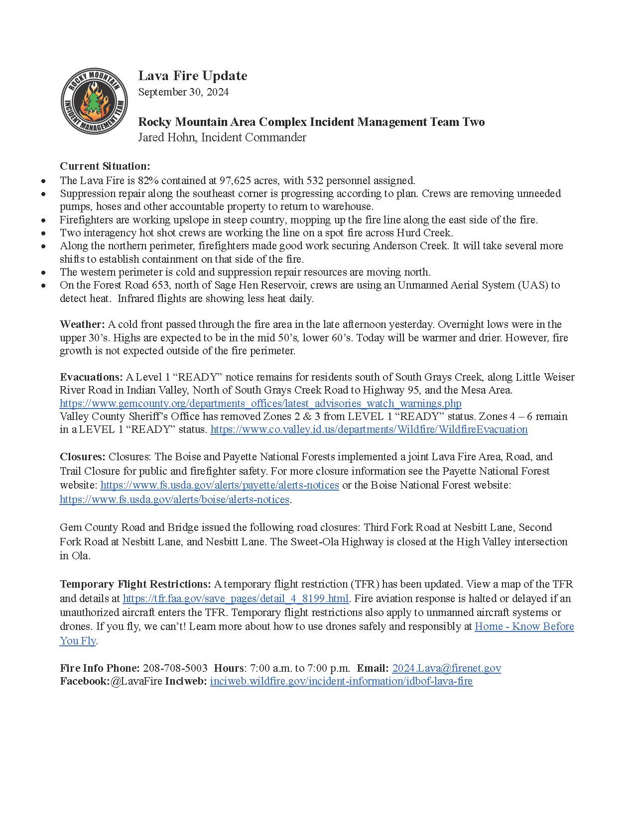
Lava Fire Daily Update 09 30 2024
Related Incident:
Publication Type: News
Current Situation:
- The Lava Fire is 82% contained at 97,625 acres, with 532 personnel assigned.
- Suppression repair along the southeast corner is progressing according to plan. Crews are removing unneeded pumps, hoses and other accountable property to return to warehouse.
- Firefighters are working upslope in steep country, mopping up the fire line along the east side of the fire.
- Two shot crews are working the line down low on spot fire across Hurd Creek.
- Along the northern perimeter, firefighters made good work securing Anderson Creek. It will take several more shifts to establish containment on that side of the fire.
- The western perimeter is cold and suppression repair resources are moving north.
- On the Forest Road 653, north of Sage Hen Reservoir, crews are using An Unmanned Aerial system (UAS) to detect heat. Infrared flights are showing less heat daily.
Weather: A cold front passed through the fire area in the late afternoon yesterday. Overnight lows were in the upper 30’s. Highs are expected to be in the mid 50’s, lower 60’s. Today will be warmer and drier. However, fire growth is not expected outside of the fire perimeter.
Evacuations: A Level 1 “READY” notice remains for residents south of South Grays Creek, along Little Weiser River Road in Indian Valley, North of South Grays Creek Road to Highway 95, and the Mesa Area. Valley County Sheriff’s Office has removed Zones 2 & 3 from LEVEL 1 “READY” status. Zones 4 – 6 remain in a LEVEL 1 “READY” Evacuation notice.
Closures: Closures: The Boise and Payette National Forests implemented a joint Lava Fire Area, Road, and Trail Closure for public and firefighter safety. For more closure information see the Payette National Forest website: https://www.fs.usda.gov/alerts/payette/alerts-notices or the Boise National Forest website: https://www.fs.usda.gov/alerts/boise/alerts-notices.
Gem County Road and Bridge issued the following road closures: Third Fork Road at Nesbitt Lane, Second Fork Road at Nesbitt Lane, and Nesbitt Lane. The Sweet-Ola Highway is closed at the High Valley intersection in Ola.
Temporary Flight Restrictions: A temporary flight restriction (TFR) has been updated. View a map of the TFR and details at https://tfr.faa.gov/save_pages/detail_4_8199.html. Fire aviation response is halted or delayed if an unauthorized aircraft enters the TFR. Temporary flight restrictions also apply to unmanned aircraft systems or drones. If you fly, we can’t! Learn more about how to use drones safely and responsibly at Home - Know Before You Fly.
Fire Info Phone: 208-780-5003 Hours: 7:00 a.m. to 7:00 p.m. Email: 2024.Lava@firenet.gov .
Facebook:@LavaFire Inciweb: inciweb.wildfire.gov/incident-information/idbof-lava-fire
Rail Ridge and Wiley Flat Fire Daily Update 09 30 2024
Related Incident:
Publication Type: News
Rail Ridge and Wiley Flat Fires Daily Update
9-30-24
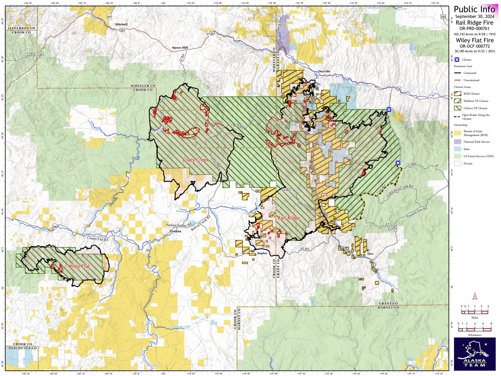
Rail Ridge Fire
Acres: 165,743 – Containment: 80% – Detection: 09/02/24 – Cause: Lightning – Personnel: 1,038
Operational Update: Yesterday, hot and dry conditions contributed to an increase in acreage on the Rail Ridge Fire. In the Black Canyon Wilderness, the fire crossed Black Canyon Creek onto the ridge east of Honeymoon Basin where firefighters and aerial resources remain engaged. Today’s weather will be much cooler, though winds will be stronger and out of the northwest, and relative humidity will be lower. Weather continues to challenge firefighting efforts. In the northern divisions, firefighters continue to mop up and extinguish isolated heat sources and are working toward suppression repair. Containment continues to increase around the perimeter. In the southern portion of the fire, patrols continue, and suppression repair is ongoing. Repairs continue along roads which received heavy impacts during suppression efforts.
Wiley Flat Fire Final Update
Acres: 30,186 – Containment: 94% – Detection: 09/02/24 – Cause: Lightning – Personnel: 27
Operational Update: Heavy equipment made progress on road repairs and falling teams are removing hazard trees along road corridors. This will be the final daily update for the Wiley Flat Fire. For questions or information moving forward, please contact the Ochoco National Forest at 541-416-6500
Weather: Today’s wind direction will change and come from the northwest. It will be a dry day as relative humidity is expected in the teens. Temperatures will be much cooler, with highs only reaching into the sixties.
Evacuations
Rail Ridge Evacuations: Level 1 and 2 evacuation zones for the Rail Ridge Fire remain in Grant County.
Wiley Flat Evacuations: Level 2 and 3 evacuation zones remain for the Wiley Flat Fire in Crook County.
For Current Evacuation Levels all affected counties, please visit: https://linktr.ee/RailRidgeFire
Closures: The U.S. Forest Service and Bureau of Land Management have implemented closures for the Rail Ridge and Wiley Flat Fires. For more details and closure maps, visit https://linktr.ee/RailRidgeFire
#RailRidgeFire2024 #WileyFlatFire2024 #FireYear2024

Goosmus Fire Update 9302024 09 30 2024
Related Incident: Goosmus Fire
Publication Type: News
Yesterday, fire behavior remained moderate as the cold front system passed over the fire area. Areas of smoke within the fire interior reflected fuels that were partially burned during the initial spread of the fire and are continuing to consume (referred to as a dirty burn). Crews are making good progress along the fire line, searching for remaining smoldering or burning areas (often stump holes or thick vegetative areas) that could compromise the line. Skidgens (modified skidders to haul water) are being utilized to access difficult areas, bringing water to crews to help in suppression areas.
Today, crews will continue on a search and destroy mission for smoldering areas along the fire line. Crews are evaluating and prepping areas for potential burnout on the northern edge of the fire. If these operations are implemented, increased smoke will be visible into the afternoon. With an overall reduction in fire behavior and an increase in strengthening the fire line, evacuation levels are being lowered today at 9:00am. Firefighter and public safety remain our highest priority, crews are continuing to work in the area. Local residences and property owners entering the area should be cautious of crews working along 4th of July Creek Road and traveling along Big Goosmus Road, Brenner Road, and Parelandra Circle, as well as other local roads in the proximity of the fire perimeter.
Evacuations and Closures:
Level 2 Evacuation are in effect for residences along 4th of July Creek Road
Level 1 Evacuations: Town of Danville and the area north of Big Goosmus Road, along Highway 21 to the Canadian Border.
Roads: Big Goosmus Road and 4th of July Creek Road are closed to the public (LOCAL RESIDENCE ACCESS ONLY)
HomesteadDiamond Complexes and Lane 1 Daily Fire Update 09 30 2024
Related Incident: Lane 1 Fire
Publication Type: News
Homestead/Diamond Complexes and Lane 1 Fires
Sept. 30, 2024
Fire Information: 541-208-7100, 8 AM - 8 PM
InciWeb-Homestead: https://t.ly/syeHa and InciWeb-Diamond: https://bit.ly/4gCfLsp
Seven fires within the Homestead Complex, Lane 1, and Diamond Complex remain under active management by Northwest Team 12. Firefighting resources from the Homestead/Diamond Complexes remain available for initial attack response to new fire starts in the area as needed.
Homestead Complex: 10,041 acres, 35% contained │ Lane 1: 25,951 acres, 99% contained │ Diamond Complex: 11,141 acres, 90% contained │ Total personnel: 570
Fire activity was influenced by gusty, dry conditions yesterday resulting in isolated tree torching, backing, and creeping fire behavior on the Horse Heaven and the Fuller Lake Fires. A Burned Area Emergency Response (BAER) Team of interdisciplinary resource specialists assessed resource damage from the fires during a reconnaissance flight. This team will determine appropriate emergency stabilization work required to minimize threats to life, property, and natural resources resulting from the effects of the fires.
Firefighters continue mop-up and patrol work on the Horse Heaven Fire. A heavy helicopter dropped 13,500 gallons of water yesterday to slow fire activity in the northwest portion of the fire. On the southern fire perimeter, engine crews removed hose from the fireline where it was no longer needed. Masticators finished work along Forest Service Road (FSR) 3831 on the north side of the fire. Additional chipping, grading, and mastication will continue in other areas of the fire. Resource advisors will assess these suppression repairs to ensure this work will be effective in preventing further resource damage.
The Fuller Lake Fire continues to produce visible smoke as it backs and creeps into the Boulder Creek Wilderness. Firefighters are engaged in ongoing chipping and hazard tree removal along road systems outside the wilderness area. On the Bullpup Fire, crews and excavators are making excellent progress with clean-up along FSRs 200, 300, and 3810 and grading will continue along FSR 5850.
The No Man Fire remains in patrol and monitor status presenting no signs of smoke or fire activity. On the Lane 1 Fire, excavators completed dozer line repair work in the Fairview area.
Two fires remain uncontained on the Diamond Complex. Chipping equipment continues to mulch woody debris on the Potter Fire and dump trucks are hauling these chips to the Diamond Lake area. Fire managers estimate a few more days of chipping work remains. The Pine Bench Fire continues to show no visible smoke.
Closures: The Umpqua National Forest and the Bureau of Land Management (BLM) have revised closure orders. Two closure orders impact the Umpqua National Forest https://t.ly/Mvn6G. A BLM Roseburg District closure order remain also remains in place https://t.ly/uWX6l. A Temporary Flight Restriction remains in effect https://bit.ly/3XJL0cD.
Weather: Well-above seasonal normal temperatures return to the area today and north-northeast winds will bring very dry conditions. Temperatures today will range from 70 to 85 degrees across the fire areas.
Line Fire Fact Sheet 09 30 2024
Related Incident: Line Fire
Publication Type: News
The Line Fire made a run up the Santa Ana river drainage today. The last few days of above normal temperatures have dried out both the vegetation and moisture from the air. Firefighters had expected some movement along the open line in this area however, fire behavior exceeded expectations. The dry vegetation, steep slopes and wind aligned yesterday to create conditions for the rapid fire spread yesterday.
Due to this rapid fire growth, evacuation orders were issued for the Barton Flats and Seven Oaks areas. Evacuation warnings are in place for Angelus Oaks and the southwestern side of Big Bear Lake.
Although work continues in throughout the fire, the Santa Ana River drainage is the priority for today. Additional crews and equipment are focused in this area. Four night-flying helicopters are assigned to the incident and were actively dropping water in the drainage last night.
The San Bernardino National Forest is now in unified command with San Bernardino County Fire, CALFIRE San Bernardino and the San Bernardino County Sheriffs Office. Additional crews, equipment and air resources have arrived and more will be coming today.
Red Rock and Black Eagle Fire Daily Update 09 30 2024
Related Incident:
Publication Type: News
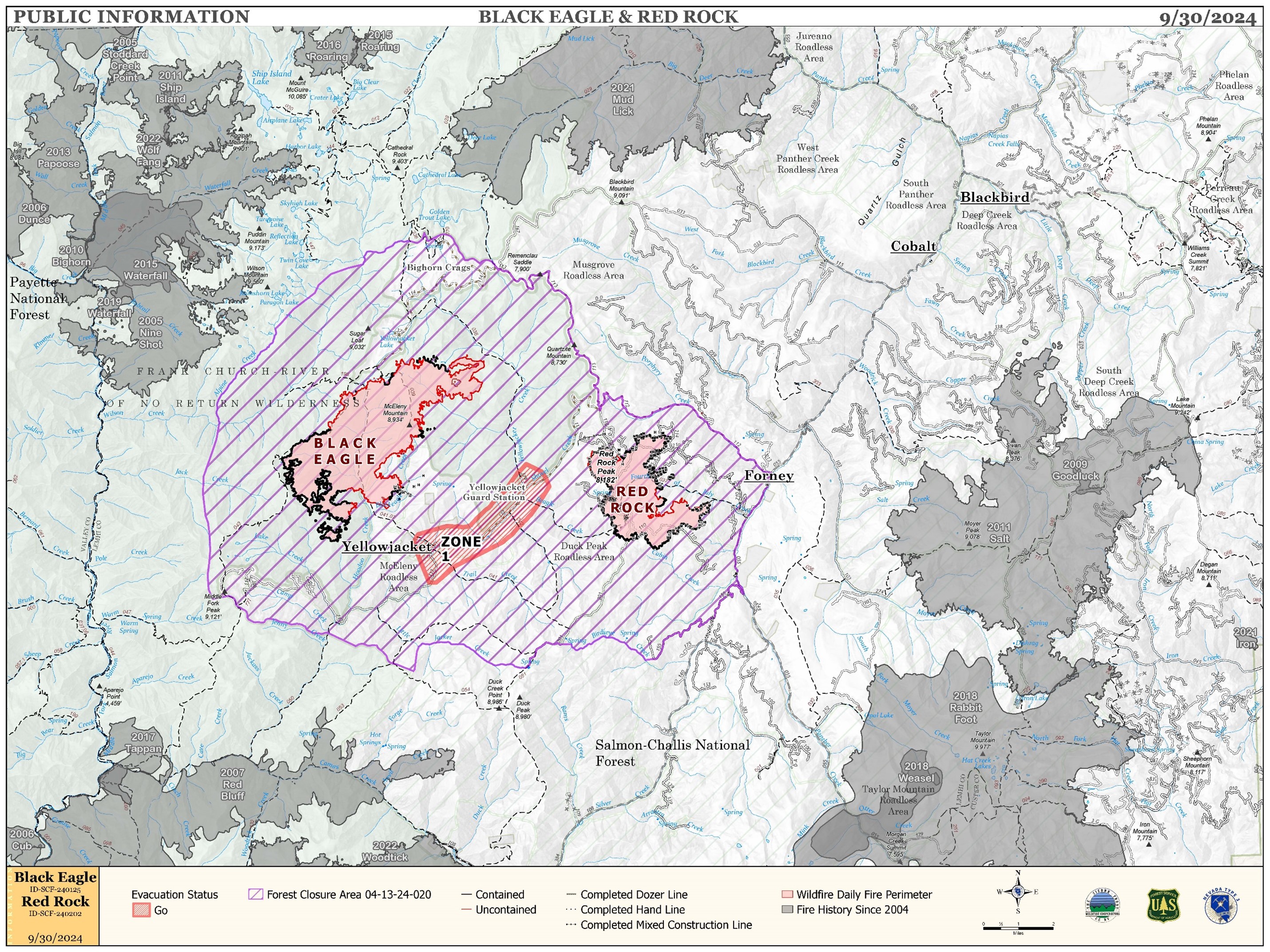
FIRE ACTIVITY:
The Red Rock Fire is at 3,277 acres and 75% containment.
Poor overnight humidity recovery and gusty winds led to an active day of fire activity yesterday. Fire behavior increased throughout the day as winds steadily increased and RH dropped into the upper teens. The fire spotted across Fourth of July Creek but crews were able to contain the spot. The southwest winds tested the uncontained line on the eastern edge as those drainages were in direct alignment. Aircraft use was needed to maintain control in areas of increased activity, although winds limited full use of those assets.
The Black Eagle Fire is at 7,313 acres and 8% containment.
The Black Eagle Fire also increased throughout the day as winds steadily increased and humidity dropped to 15-20%. Westerly winds continued to test the northeast area of the fire as heavy fuels were in alignment with the winds and fire backed slowly down towards Yellow Jacket Creek. Use of aircraft was needed to maintain control in areas of increased activity, although winds limited full use of those assets.
WEATHER:
The front that moved over the incident Sunday brought cool, dry air to the area. Today’s temperatures will be 10 degrees cooler than Sunday and humidity will struggle to reach 14%. Winds will be much lighter today as high pressure builds into the area. No precipitation is expected through the next six days.
FIRE BEHAVIOR:
Nearly all fuels are available across both fires, though heavy dead and down fuels remain most problematic for firefighters. Areas where humidities fall below 25% with gusty afternoon winds can experience increased activity, including short-range spotting. Opportunities to attack the fire directly will likely be confined to morning hours and when effective water support is available.
FOREST CLOSURES: For forest closure information please go to: https://www.fs.usda.gov/alerts/scnf/alerts-notices
EVACUATIONS: For evacuation information in Lemhi County regarding these fires please go to: Emergency Management Department | Lemhi County, ID (lemhicountyidaho.org).
Elk Fire Daily Update Monday September 30 2024 09 30 2024
Related Incident: Elk Fire 2024
Publication Type: News
Wyoming Type III Team, Incident Commander: Matt Weakland
Location: Approximately 6 miles northwest of Dayton, Wyoming
Start Date: Friday, September 27, 2024
Cause: Lightning
Size: (6,312 acres night of September 29) The fire grew at least 8 miles to the south overnight. Maps will be posted once data is available.
Percent contained: 0%
Resources: 7 Hand Crews; 3 Engines; 3 Heavy Equipment; 2 type 1 Helicopters, 1 type 2 Helicopter , 1 air attack, air tankers as available.
FIRE STATUS:
Yesterday, the fire significantly increased in size. All air operations were put on hold for several hours due to high winds. Evacuations were issued along Pass Creek and Sheridan County Road 144, Pass Creek is closed to all non-resident traffic.
As of the morning of September 30, out-building structures have likely been lost. Local Law enforcement and firefighters are working with the Sheridan County Sheriff’s Office to notify property owners of structures lost.
Fire crews will focus on working to protect structures along the face of the mountain in the Pass Creek, Smith Creek, and Twin Creek areas. Thank you to Sheridan County Fire for structure protection work all throughout the night of September 29 and early morning of September 30.
A Complex Incident Management Team has been ordered to take over command of the fire. Wyoming Type III will remain in place until a transition can occur.
The objective is to protect critical values at risk. These values include firefighter and public safety, lands and property off National Forest Lands, two cow camps and a radio repeater site.
The strategy is full suppression. The team is utilizing all available tactics with firefighter and public safety as the primary decision driver. The approach to suppress the fire will be conducive to the terrain, conditions, and medical team response time.
WEATHER AND FIRE BEHAVIOR:
The weather is expected to change with much cooler day and night temperatures today. Wind direction is forecasted to change.
AIR QUALITY AND SMOKE:
It is expected that the fire will continue to put up a smoke column, please check the AirNow website at https://www.airnow.gov/ to monitor smoke movement.
CLOSURES:
A closure order is in effect to protect the safety of firefighters and the public. An area including, Forest System Roads 145,150, 114, and portions of 167 and 168 along with Forest System Trails 201, 077, and 428 will be closed to public entry.
Sheridan County has closed Pass Creek Road, Twin Creek, Smith Creek Road, and Tongue River Canyon Road to non-resident travel.
Residences have been evacuated. Law enforcement and fire personnel are contacting affected people directly. If people need shelter for livestock or themselves, please call Sheridan County Emergency Management at 307-752-2174.
This order is being put in place to protect firefighter and visitor safety. The roads are being heavily used by firefighters, including large equipment. If you can, please avoid travel in the general area. If you need to remove personal equipment from the closure area or roads behind it, please contact 307-683-7019.
Morning Update Frog Fire Monday 09 30 2024
Related Incident: Frog
Publication Type: News
Frog Fire Statistics
- Size: 3,113 acres
- Containment: 66%
- Total Personnel: 81
- Location: east of Clayton, ID
- Reported: September 7, 2024
- Cause: Lightning
For More Information
InciWeb: https://inciweb.wildfire.gov/incident-information/idstf-frog
Facebook: https://www.facebook.com/sawtoothnationalforest
Current Situation: Despite the gusty winds yesterday, the Frog Fire held in its current footprint, with
an increase of just one acre. Good progress was made by helicopters dropping water on the west side.
While increased fire activity on the west side created more smoke than has been seen in the area in
several days, the flames were from unburned vegetation interior to the fire perimeter. Crews kept a
careful eye on the southern edge of the fire, but no significant spread was reported. This plan will
continue today with helicopters on standby in case they are needed. Resources will continue to be
reassigned from the Frog Fire to the Wapiti Fire today as well.
Evacuations: There are currently no evacuations related to the Frog Fire.
Closures: The area closure in place around the Frog Fire includes FS 667 (Big Boulder Creek Road)
and Trail 047 where adjacent to the closure boundary. The closure excludes FS Roads 669 and 670
and Trail 682. Hunters and recreationalists should familiarize themselves with this closure
information prior to entering the vicinity. Please reference the map and read the full closure
description at https://inciweb.wildfire.gov/incident-closures/idstf-frog.
Middle Fork Complex Daily Update Sept 30th 2024 09 30 2024
Related Incident:
Publication Type: News
Middle Fork Complex: 61,484 acres, 90% completion, 400 Personnel
Snag Fire: 33,436 acres, 90% completion, 41 Personnel
Goat Fire: 27,131 acres, 46% completion, 41 personnel
As the cold front moved on Sunday so did a slight increase in winds in the fire area as a result more smoke was visible then in previous days. As cooler temperatures over night start to subside in the morning we can expect relative humidities to fall from 15 to the 30th percentile. The drying trend is expected to continue throughout the day. We can expect more smoke to be visible as more fuels become available in the fire’s interior.
Middle Fork Complex – Suppression repair will continue in the Deadwood Reservoir. As heavy equipment continues to work in the area and more closures are lifted, please use extra caution when traveling in any areas nearby. Engine crews will also remain in the area continuing to check and solidify any containment lines and evaluate confinement lines.
Goat – Crews have completed most of the repair work around Clear Creek and will continue suppression repair in the private lands near Clear Creek. Hand crews will increase the depth of their mop up efforts along the containment lines. Engine companies and crews will continue to evaluate and protect confinement lines in the Northeast corner.
Snag – Suppression repair will continue across the fire area with the primary focus on hand and dozer lines. Evaluation and strengthening of containment lines will continue along the western side of the fire. Significant work is also going into suppression repair of many of the access roads used by fire personnel in all areas. This will be the final update from Great Basin Team 2. It has been the Garden Valley Community and surrounding areas.
Middle Fork Complex - Suppression Repair= 28 miles of handline completed. 13 miles of dozer line completed.
Goat and Snag Fires - Suppression Repair = 16 miles of handline completed. 7 miles of dozer line completed.
Firefighters continue work both fire suppression and suppression repair as needed so heavy firefighting equipment is moving from site to site. Please use extreme caution while traveling, especially when approaching vehicles, and at intersections.
Closure Orders: https://www.fs.usda.gov/alerts/boise/alerts-notices
Hunters are not allowed access to closed areas. We ask the public to adhere to the closures as they currently exist; in particular, Trail Creek Hot Springs is currently within the closure area for the West Mountain Complex and is closed.
Fire Restrictions: Stage 1 Fire Restrictions have been rescinded for the Boise National Forest. For more information on the restrictions visit https://www.fs.usda.gov/alerts/boise/alerts-notices.
Morning Update Wapiti Fire Monday 09 30 2024
Related Incident:
Publication Type: News
Wapiti Fire Statistics
- Size: 125,624 acres
- Completion: 75%
- Total Personnel: 344
- Location: near Grandjean, ID
- Reported: July 24, 2024
- Cause: Lightning
For More Information
- InciWeb: https://inciweb.wildfire.gov/incident-information/idbof-wapiti-fire
- Facebook: https://www.facebook.com/wapitifireinfo2024
- Linktree: https://linktr.ee/WapitiFireInfo2024
- Interactive Map: https://tinyurl.com/WapitiFireInfoMap
Special Emphasis: Collection of firewood within the closure areas is prohibited; any firewood collection in open areas must be done with a valid firewood permit. For questions on firewood collection on the Sawtooth National Forest, please contact the Stanley Ranger Station at 208.774.3000.
Weather: Gusty winds continued in the fire area yesterday with slightly lower temperatures. These winds have brought very cold weather in the 15-20 degree range this morning, returning the area to a trend of more seasonal temperatures. Winds are expected to calm down today. Less wind and slightly cooler temperatures will allow crews to make good progress on the Wapiti Fire.
Dry conditions will continue in the fire area for the next several days. “The 5% chance of rain later in the week is a very slight - wishing and crossing your fingers - kind of chance,” said John Keyes, Incident Meteorologist.
Current Situation: The increase in acreage of the Wapiti Fire is spread around the entire fire area and is not indicative of a significant increase in activity. The eastern portion of the Wapiti Fire was less active yesterday and fire activity is expected to decrease further as the winds calm down; there is no significant threat of fire spread today. Crews continued to patrol Highway 21 and areas where hot spots remain by Bull Trout Lake, Copper Mountain, and Cape Horn. Helicopter crews dropped water north of Copper Mountain into the afternoon, as long as wind conditions allowed yesterday. This work, as well as the work digging fireline around Cape Horn, will continue today. Firefighters will take full advantage of the cooler temperatures and calmer winds to make progress on the remaining heat on the Wapiti Fire.
Most of the repair work on the east side of the fire was completed yesterday, and repair on the west side will be concluded soon. The bulk of resources working on the east side of the fire have been freed up to assist with the repair of Grandjean Road. The repair of Grandjean Road still has several days of work left, ensuring time is taken to make the right decisions to complete repair in the most effective way possible. Felling hazard trees on Road 630 will continue today.
Evacuations: Evacuation status for Stanley Zone 1 is currently at READY. Stanley Zones 2 – 5 and Kasino are no longer in an evacuation status. Sign up for Custer County CodeRED emergency notifications: text CUSTER to 99411 or enroll at https://public.coderedweb.com/CNE/BF28E45537FF.
All Boise County evacuation levels have been lifted; residents should remain alert for any change in conditions which could reinitiate an evacuation status. Sign up for Boise County Alert Sense emergency notifications at https://public.alertsense.com/SignUp/publicUser.aspx?regionid=1163.
For evacuation information on the Wapiti Fire, please see the Custer County Sheriff’s Facebook page, https://www.facebook.com/p/Custer-County-Sheriff-Idaho-61558947312289/, and the Boise County Sheriff’s Facebook page, https://www.facebook.com/boisecountysheriff/.
Closures: The Wapiti Fire area closure covers portions of the Sawtooth, Boise, and Salmon-Challis National Forests. Please reference the map and description at https://inciweb.wildfire.gov/incident-closures/idbof-wapiti-fire. Recreationalists and hunters should reference this map and obey all posted signage regarding the closure area and any related road, trail, and campground closures.
An interactive map for all closures on the Boise National Forest is found at https://experience.arcgis.com/experience/642380b0eb124c8cab6bd9ad3d7146ad/page/Overview/#data_s=id%3AdataSource_5-1888bd00a2c-layer-13-1888bd00b53-layer-16%3A82