
Thomas Mountain Broadcast Burn San Jacinto Ranger District 61523 Evening Update
Related Incident: 2023 - San Bernardino National Forest Wildfire Crisis Response
Publication Type: News
6/15/23 - Evening Update - Burn operations have concluded successfully on the Thomas Mountain prescribed burn. Firefighters from the San Bernardino National Forest, with the assistance of crews from the Angeles National Forest, Los Padres National Forest, Cleveland, National Forest, and Idyllwild Fire Protection District had an amazing and successful first day. With everyone's dedication and hard work a total of 150 acres was completed and crews were able to establish a solid anchor point which will allow crews to continue solid work tomorrow. The fuels presented great fire effects with great consumption meeting all burn project intents.
Smoke may still be visible throughout the evening. Crews will be starting operations again tomorrow at 9am.
Spice Lake Fire Closure Order FAQ
Related Incident:
Publication Type: Closures
EMERGENCY CLOSURE ORDER OF THE FOREST SUPERVISOR
BWCAW Spice Lake Wildfire Closure Order
ON THE SUPERIOR NATIONAL FOREST
Effective June 16, 2023
Frequently Asked Questions (FAQ)
Order NO: 09-09-23-03
Q. Why is there going to be a closure for such a small wildfire?
A. No two fires are alike, it is about the complexity of the fire. And due to the complexity of the Spice Lake fire, the closure is necessary. These are not normal circumstances, the drought, warm temperatures, unpredictable high winds and fuel loads are creating a dangerous condition for our firefighters and the recreating public. In addition, the fire is in a unique area of the Forest – a designated Wilderness, which is managed differently. As we learned during the Greenwood fire, the closure order is needed to prioritize safety.
Additional factors considered for this closure include but are not limited to: the area being highly remote, it has limited communication capacity, it takes an extended length of time to paddle the area, the capacity for extreme fire behavior and excessive fuel conditions all lend to a large fire growth potential. These factors combined require a large closure area until we have complete containment.
Q. Are there going to be cancellations of permits on the BWCAW?
A. The forest has contacted the cooperators and current BWCAW permit holders with permits for Moose, Snowbank, Seagull, Saganaga and Kek trail east and west entry points and have encouraged them to seek alternative experiences. On June 19, the forest will review the permit levels and make any adjustments as needed.
Q. I used a cooperator for my permit for this area, what do I do?
A. Contact your cooperator to discuss your trip and possible options, permits in other areas are still available.
Q. Which points of entry are affected by this Closure order?
A. Although one can access this area by several entry points, Moose Lake, Saganaga Lake, Seagull Lake, Kekekabic Trail (West) and Snowbank are the entry points that most people use to travel to the area affected by the closure order.
Q. How long will the closure be in place?
A. Public lands closures help to reduce interference with emergency crews and allow for fire suppression and burned area recovery. The Forest Closure Order is effective June 16, and will remain in effect until the fire is declared out, unless sooner rescinded. The Forest wants to express gratitude for the public's patience as we work to reopen these special places as quickly as safely possible.
Please remain vigilant while out on your public lands. Fuel conditions remain very dry and new fire starts are possible. Help us thank firefighters, and protect your community from new, human-caused fires by following the public use restrictions that are still in place. There is a campfire restriction in place across the forest.
Q. How do I find daily updates or more about the Spice Lake Wildfire?
A. Go to Inciweb for this incident can be found at https://inciweb.wildfire.gov/incident-information/mnsuf-spice-lake-fire You will find information on other wildfires on this website as well.
Q. How many campsites will be affected by this closure on the BWCAW? And are there permits available for other points of entry?
A. There are 80 campsites that are affected.
Yes, there are still permits available at other points of entry. We are encouraging people to seek alternate locations for your visit, either on the BWCAW or at any of the 23 developed campgrounds and 18 rustic campgrounds. There are 254 backcountry campsites outside the wilderness that offer remote paddling, camping and fishing. Here you can experience solitude without reservations, fees or permits and have similar amenities that you would find in a Wilderness campsite. Many backcountry campsites are located on canoe routes outside the BWCAW. State forests and parks and county lands are also available for recreation.
Q. Why isn’t the Forest Service using a Full Suppression approach to this wildfire?
A. The Forest Service is using a full suppression approach. By Forest Service policy, every fire receives a strategic, risk-based response appropriate for the circumstances and associated threats and opportunities. Each strategy uses the full spectrum of management actions that consider fire and fuel conditions, weather, values at risk and resource availability.
Fire danger is high from Duluth through Arrowhead due to drought conditions, warm weather, and high winds. Fire danger is likely to remain high through the end of June. In addition to the weather conditions, this area includes high fuel loads, due to spruce budworm affected trees – both standing and laying down that can increase fire behavior.
Because of these factors, the Type 3 team is prioritizing firefighter safety using indirect tactics to suppress the fire. These are not normal conditions, and the Forest Service is responding in the best way possible.
Q. Can I fly a recreational drone over the wildfire to take photos?
A. No, flying drones or Unmanned Aircraft Systems (UAS) within or near a wildfire without permission could cause injury or death to firefighters and hamper their ability to protect lives, property, and natural cultural resources.
Individuals who fly UAS without authorization over wildfires may be violating federal, state, and/or local laws, regulations, and ordinances, whether a Temporary Flight Restriction (TFR) is in place or not. All unauthorized UAS flights over wildfires on National Forest System lands will be reported to the Federal Aviation Administration (FAA) and law enforcement agencies.
Individuals who have been determined to have endangered manned aircraft or people on the ground with a UAS and/or interfered with wildfire suppression may be subject to civil penalties, including fines of up to $25,000, and potentially criminal prosecution.
Q. How is the current air quality situation affecting wildfire operations?
A. Currently there is an air quality alert in affect through June 16 for northern and central Minnesota due to wildfire smoke from Canada. Air quality is expected to reach the read AQI category in northern and central Minnesota, which is unhealthy for everyone.
Safety is our number one priority and, in some instances, aviation resources like planes, helicopters, etc. may not be used in suppressing a fire because of continued air pollution from Canadian wildfires.
Spice Lake Fire Closure Order 09092303
Related Incident:
Publication Type: Closures
EMERGENCY CLOSURE ORDER OF THE FOREST SUPERVISOR RESTRICTING OCCUPANCY AND USE, TO WIT:
SUPERIOR NATIONAL FOREST SPICE LAKE FIRE
Pursuant to the provisions of 16 U.S.C. § 551, and 36 C.F.R. §§ 261.50 (a) and (b), the following acts are prohibited in the Superior National Forest, due to hazards on portions of lands within Boundary Waters Canoe Area Wilderness (BWCAW) and trails in Cook and Lake Counties, Northeastern Minnesota. These restrictions go into effect at 12:01 a.m. on Friday, June 16, 2023.
Restrictions Enacted on Friday, June 16, 2023, remain in effect.
The following are prohibited:
It is prohibited to enter the following entry points, lakes, and trails which are posted closed and are depicted in Exhibit A. 36 CFR 261.53(e) Special Closures, Public Health or Safety.
BWCAW CAMPSITES, PORTAGES, LAKES AND TRAILS:
• All trails, campsites, portages, rivers and lakes that are within the closure area shown in Exhibit A, including but not limited to Agamok Lake, Ahmakose Lake, Amoeber Lake, Annie Lake, Ashdick Lake, Bonnie Lake, Callico Lake, Cap Lake, Cherry Lake, Clam Lake, Eddy Lake, Ester Lake, Fee Lake, Gijikiki Lake, Hanson Lake, Hoe Lake, Holt Lake, Jasper Lake, Jenny Lake, Kek Ponds, Kekekabic Lake, Kingfisher Lake, Knife Lake (partially closed), Lake of the Clouds, Ledge Lake, Little Knife Lake, Lunar Lake, Mueller Lake, Mueller Lake, Nabek Lake, Ogishkemuncie Lake, Ottertrack Lake, Pickle Lake, Rabbit Lake, Rivaly Lake, Roe Lake, Sagus Lake, Sema Lake, Skindance Lake, South Arm of Knife Lake, Spice Lake, Spoon Lake, Strup Lake, Toe Lake, Topaz Lake, Vee Lake, Wisini Lake.
• All zones of the Pitfall Pristine Management Area (1 through 3), and the Mugwump Pristine Management Area (1 through 5).
• The Kekekabic Trail- the area from the BWCAW boundary west of the Gunflint Trail to the series of portages between Thomas Lake and Ima Lake (see Exhibit A).
These emergency restrictions are necessary for the public's health and safety due to wildland fires in the vicinity of the affected lands, waters, trails, portages, canoe routes, and all recreation sites. These restrictions will remain in effect for as long as they are posted on-site and until terminated by the forest supervisor.
1. Persons with permit specifically authorizing the otherwise prohibited act or commission (36 CFR 261.50(e)(1)).
2. Any Federal, State, or local officer, or member of any organized rescue or fire fighting force in the performance of an official duty (36 CFR 261.50(e)(4)).
3. Persons engaged in a business, trade or occupation in the area, when authorized and when accompanied by a Forest Officer or official member of the Incident Command Team (36 CFR 261.50(e)(5)).
Violation of these prohibitions is punishable by a fine of not more than $5000.00 for an individual or
$10,000.00 for an organization, or imprisonment for not more than six (6) months, or both (16 U.S.C., 18 U.S.C. 3559
and 3571).
Dated this 15 day of June 2023, at Duluth MN.
THOMAS HALL
Forest Supervisor
Superior National Forest to Close area around Spice Lake Wildfire within the Boundary Waters Canoe Area Wilderness
Related Incident:
Publication Type: News
Superior National Forest
Forest Service News Release
Joy VanDrie: Public Affairs Staff Officer
231-878-0887
https://www.fs.usda.gov/superior
Superior National Forest to Close area around Spice Lake Wildfire within the Boundary Waters Canoe Area Wilderness
A portion of lands within the BWCAW in the Superior National Forest will be closed effective June 16.
Duluth, Minn. June 15, 2023— Due to the Spice Lake Wildfire on the Superior National Forest (SNF), Forest Supervisor Tom Hall is closing a portion of the Boundary Waters Canoe Area Wilderness (BWCAW) with an Emergency Forest Order - effective June 16 – prohibiting visitor entry at specific campsites, portages and lakes, and Pristine Management Areas (Forest Order 09-09-23-03#). The restrictions will go into effect beginning Friday morning (12:01) a.m., June 16, 2023; see Exhibit A of the Forest Order for a map of the area. The closure may be modified or extended as conditions allow.
The Forest Order closures include:
- All trails, portages, rivers, and lakes within the closure area (see in Exhibit A), including but not limited to 47 locations as noted.
- All zones of the of the Pitfall Pristine Management Area (1 through 3), and the Mugwump Pristine Management Area (1 through 5).
- The Kekekabic Trail- the area from the BWCAW boundary west of the Gunflint Trail to the portage between Strup Lake and Kekekabic Lake (see Exhibit A).
The Forest Service has notified permit holders and outfitters, and is encouraging permit holders to seek an alternate area of the BWCAW or consider non-wilderness areas of the SNF (see below) for similar experiences. At this time overnight paddle, day use and motorized day use is not permitted in the closure area.
We understand that this will have a significant impact on our visitors, cooperators, and communities near the SNF. This emergency closure is necessary for the safety of our visitors, our wilderness rangers and our fire-fighters.
Northern Minnesota is facing severe to extreme drought conditions, causing active and increasing fire across the landscape. A Type 3 team is managing suppression actions on the Spice Lake Fire with additional resources on standby. Additionally, the Forest is monitoring the fires in Canada. The Forest is coordinating with Ontario counterparts.
Beyond the closures for the Spice Lake Fire, the Forest is open to the public. We do have a campfire restriction in place across the Forest– see website for details.
There are 254 backcountry campsites outside the Wilderness that offer remote paddling, camping and fishing. Here you can experience solitude without reservations, fees or permits and still have similar amenities to that of a BWCAW campsite. Many backcountry campsites are located on canoe routes outside the BWCAW. State forests and parks and county lands are also available for recreation.
For more information on recreation alternatives outside the BWCAW, please visit: Superior National Forest - Water Activities:Boating - Non-Motorized (usda.gov) For a list of canoe routes with backcountry campsites in the Superior National Forest, visit: Canoeing 2012 rev 0415 final.pub (usda.gov)
The Superior National Forest also offers 23 developed campgrounds and 18 rustic campgrounds. Rustic campgrounds are free of charge and available first come, first served year-round. Fee campgrounds are open May – September and may be reserved at Recreation.gov. See the Forest website for more information.
Thank you for your cooperation.
For additional information regarding fire-related and/or forest closures and updates:
- Inciweb for this incident can be found at https://inciweb.wildfire.gov/incident-information/mnsuf-spice-lake-fire
- See the Superior National Forest website www.fs.usda.gov/superior,
- SNF Forest Orders are available here: https://bit.ly/SNFforestorders
- FAQs for this closure can be found on the forest website www.fs.usda.gov/superior
- Fuels and Fire Behavior Advisory
- www.predictiveservices.nifc.gov/fuels_fire-danger/Fuels_Fire_Behavior_Advisory_EA_NortheastMN_WI_MI_20230612.pdf
Political/Cooperator Notification:
With health and safety in mind, please see attached a closure order going into effect this Friday, June 16. We encourage you to work with your visitors who have permits to enter Moose, Snowbank, Sananaga and Seagull entry points to change their plans away from the affected area. Once the public is aware of the closure, we are anticipating an organic reduction in permits due to visitor-initiated cancellations. However, we will review the permits levels for these points of entry on June 19 and if the levels have not decreased to a manageable level, we may be forced to cancel reservations to ensure we do not experience crowding or lack of campsite availability in the area of the BWCAW near the closure area.
We hope you consider the options for your customers and seek alternate experiences.
Rec.gov Permit Holder Notification:
Your reservation is located in an area of the BWCAW that is currently under a closure order due to wildfire activity. Your reservation has not been cancelled. However, there is the potential that your permit could be cancelled as conditions change.
For those wishing to rebook a permit for an alternative entry point in the BWCAW, check current availability at: Boundary Waters Canoe Area Wilderness, Superior National Forest - Recreation.gov and click on “Explore Available Permits” or contact your BWCAW cooperator. Additionally, there are 254 backcountry campsites outside the wilderness that offer remote paddling, camping, and fishing where you can experience solitude without reservations, fees, or permits and still have a latrine and fire grate (campfire ban in effect for Superior National Forest). Visitors must follow the same Leave No Trace principles listed on page 5 of the BWCAW Trip Planning Guide. For more information on recreation alternatives outside the BWCAW, please visit: Superior National Forest - Water Activities:Boating - Non-Motorized (usda.gov) For a list of canoe routes with backcountry campsites in the Superior National Forest, visit: Canoeing 2012 rev 0415 final.pub (usda.gov)
Emergency restrictions are necessary for the public's health and safety due to wildland fires in the vicinity of the affected lands, waters, trails, portages, canoe routes, and all recreation sites. Local officials continue to monitor the changing conditions. For the latest information on wildfires and closure orders, please visit Superior National Forest - Home (usda.gov) and scroll to “Alerts & Warnings” on the right side of the Forest home page. Follow the latest postings on Twitter (@SuperiorNF) or on Facebook at: U.S. Forest Service-Superior National Forest - Home | Facebook.
Boundary Waters Canoe Area Wilderness, Superior National Forest - Recreation.gov
Explore Boundary Waters Canoe Area Wilderness in Superior National Forest, Minnesota with Recreation.gov. Click 'Show Notification' arrow in the upper right corner of this page to read the latest a...
Settings - change map background and toggle additional layers
Filter - control incident types displayed on map.
Zoom to your location
Reset map zoom and position
Could not determine your location.
Show Legend
 Wildfire
 Prescribed Fire
 Burned Area
Response
Burned Area
Response Other
Other
Ridge Fire
Unit Information
Incident Contacts
Settings - change map background and toggle additional layers
Filter - control incident types displayed on map.
Zoom to your location
Reset map zoom and position
Could not determine your location.
Show Legend
- Wildfire
- Prescribed Fire
- Burned Area
Response
- Other
Hull Fire
Unit Information
Incident Contacts
Fire Facts Sheet June 14 2023
Related Incident:
Publication Type: News
Superior National Forest | June 2023
Spice Lake Fire Fact Sheet
Date: June 14, 2023 5:00PM
Fire Information: 218-248-7240 or the Superior National Forest website: www.fs.usda.gov/superior
Incident Name: Spice Lake Fire Size: Estimated at 20 acres
Location: Near Spice Lake within the Boundary Waters Canoe Area Wilderness (BWCAW), Superior National Forest, Lake County, Township 65 North, Range 6 West, Section 27
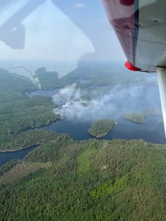
Current Status: Late in the afternoon on June 13th, a wildfire was detected between Spice Lake and Ogishkemuncie Lake in the Boundary Waters Canoe Area Wilderness (BWCAW) on the Gunflint Ranger District of the Superior National Forest. Spice Lake is located east of Knife and Kekekabic Lakes and southwest of Seagull Lake, approximately 10 miles west of the Gunflint Trail. The cause of the fire has not been determined.
At the time of detection, the fire was actively burning in a mixed Boreal forest with aspen, pine, and balsam fir tree species. Within the forested landscape of the fire area, there are Spruce Budworm affected trees, both standing and dead laying down that can increase fire behavior.
Fire managers took an aircraft flight over the fire this morning to start developing strategies and tactics for suppression while ensuring firefighter safety. The fire was creeping and smoldering at mid-morning. Additionally, staff are working on a public safety plan including a closure order for the area to ensure public visitors remain safe. Additional details will be shared as these plans are developed.
Aircraft have been dropping water on the fire throughout the day and this afternoon’s report is that the fire is estimated at 20 acres with low fire behavior. Firefighters are being transported to the area using float planes.
Planned Actions: Firefighter resources including a 19-person hotshot crew will arrive at the fire within the next few days to access and work the fire on-the-ground as needed. Public safety staff will begin sweeping the area for any visitors located near the fire area.
Resources: A 19-person off-Forest hotshot crew. Additional Forest fire staff may be on the fire as point of contacts. A helicopter and other aerial resources are available to assist suppression activities as needed. The Forest’s Beaver airplane will patrol the fire area, shuttle personnel and gear, and could drop water as needed for fire suppression. Due to the logistics of supporting firefighters on this Wilderness fire a Minnesota Type 3 team has been ordered and will in-brief on June 15, 2023.
Area Closures: The Superior National Forest will be implementing a closure restriction in the near future for a travel area around the fire for public safety. Public safety crews will sweep the closure area to redirect visitors and post portages closed.
Fire Restrictions: The Superior National Forest has implemented a Forest Order (09-09-23-02) for campfire restrictions due to continued dry conditions and worsening wildfire danger. This Order will remain in effect until further notice. See the Superior National Forest website https://www.fs.usda.gov/superior for more information on fire restrictions.
Fire Facts Sheet June 13 2023
Related Incident:
Publication Type: News
Incident Name: Spice Lake Fire Size: Estimated at 30 acres
Location: Near Spice Lake within the Boundary Waters Canoe Area Wilderness (BWCAW), Superior National Forest, Lake County, Township 65 North, Range 6 West, Section 27
Current Status: Late in the afternoon on June 13th, a wildfire was detected between Spice Lake and Ogishkemuncie Lake in the Boundary Waters Canoe Area Wilderness (BWCAW) on the Gunflint Ranger District of the Superior National Forest. Spice Lake is located east of Knife and Kekekabic Lakes and southwest of Seagull Lake and approximately 10 miles west of the Gunflint Trail. The cause of the fire has not been determined.
An aircraft flight was taken over the fire for a size up of the fire’s activity and location. Active and moderate fire activity was witnessed in a mixed Boreal forest with aspen, pine, and balsam fir tree species. There is also evidence of Spruce Budworm affected trees which means dead down and standing trees which can cause active fire behavior. Fire personnel also looked for public canoe groups on the area lakes and made contact with several groups on Ogishkemuncie Lake and to ensure public safety directed them off the lake to the east.
Fire personnel will fly over the fire again tomorrow morning and are developing a fire suppression plan while ensuring firefighter safety. Additionally, staff will begin working on a public safety plan for the area to ensure public visitors remain safe. Additional details will be shared as these plans are developed on Wednesday, June 14.
Thomas Mountain Broadcast Burn San Jacinto Ranger District 61523
Related Incident: 2023 - San Bernardino National Forest Wildfire Crisis Response
Publication Type: News
June 15, 2023 - The San Bernardino National Forest (BDF) San Jacinto District will be conducting a prescribed burn today through June 22nd. This operation will cover approximately 2500 acres on Thomas Mountain; west of the community of Garner Valley and southeast of the communities of Idyllwild and Mountain Center. Residents and visitors will see flames and smoke visible throughout the day and evening. Firefighters will be monitoring the area until all fire is extinguished.
There will be more than 100 firefighters from the Forest Service and partner agencies involved in this operation. These ignitions will be carried out through ground-based and helicopter aerial operations. After the active ignitions, there will be several additional days dedicated to mop-up, securement, and patrolling as needed.
During broadcast burning, fire is spread across the landscape in a controlled manner, typically using specialized equipment such as drip torches or aerial ignition devices. These fires are closely monitored to ensure that they remain within the designated area and do not spread beyond control.
If you are traveling on California Highway 74 you may experience brief closures due to aerial operations. These closures are to protect both the firefighters involved in the operations and the public using the highway.
During these operations certain areas will be temporarily closed to the public: Forest Road 6S13, Tool Box Springs Yellow Post Sites, Thomas Mountain Yellow Post Sites and the Ramona Trail. These closures are implemented for the safety of both the public and firefighters involved in the operations.
#PrescribedBurn #PrescribedFire #ForestHealth #ThomasMountainPrescribedBurn
20230614PassFireUpdate
Related Incident:
Publication Type: News
Today is the final update on the Pass Fire. Moving forward, updates will be released twice per week, unless fire behavior changes significantly. Please also note the Pass Fire information phone number has changed.
Acres: 50,123
Start Date: May 18, 2023
Location: 40 miles west of Winston, NM
Cause: Lightning
Containment: 13%
Fuels: Timber, pinon/juniper and grass
Personnel: 54
Southwest winds for the past couple of days have aided the Pass fire to steadily consume ground fuels and surface vegetation. An infrared flight last night showed 288 acres of new growth within isolated pockets of heat. Fire activity was observed in Trap Corral Canyon just west of Trap Corral Tank. Most of the fire activity is still located between House Log Canyon and Windfall Canyon.
Firefighters will continue collecting fuel samples to stay informed of current fuel moistures that will assist with forecasting future fire behavior. Their daily missions are to patrol and monitor the Pass Fire from the air and ground, taking appropriate measures to ensure it stays confined within the identified boundaries and protect values at risk.
Visitors are reminded to use extreme caution and exercise common sense when traveling near the fire area.
The low-to moderate intensity of the Pass fire is thinning out crowded young stands of trees, reducing the amount of fuel on the forest floor, add nutrients to the soil to rejuvenate plant life which will produce new forage for wildlife.
Weather: Sunny, with highs around 80. West winds from 5 to 10 mph, increasing to southwest 20 to 25 mph this afternoon.
Aviation Restrictions: A Temporary Flight Restriction (TFR) is still in place over the Pass Fire. All non-fire aircraft are restricted. This includes civilian drones. Unauthorized aircraft in the area will ground firefighting aircraft, hindering firefighting efforts. If you fly, we can’t.
For More Information:
- Inciweb: https://inciweb.wildfire.gov/incident-information/nmgnf-pass-fire Inciweb is the official site for fire information. This site is secure and updated daily.
- New Mexico Fire Information: https://nmfireinfo.com/
- Air Quality: https://www.airnow.gov