
New Lighting Fire on the Klamath NF Contained at 2 Acres
Related Incident: 2023 Klamath NF Spring Lightning Fires
Publication Type: News
A new lightning-caused fire was reported this afternoon on the Klamath National Forest. The Cold Fire is located on the Goosenest Ranger District, on the northwest side of Willow Creek Mountain. KNF crews were joined by CAL FIRE and Montague Fire resources on the initial attack and contained the fire at .2 acres. The Cold Fire will remain in patrol status until called out.
The Cold Fire is the third fire on the KNF caused by the recent lightning activity. The Willow Fire, also on Willow Creek Mountain, was reported on May 29 and was contained that day at .25 acres. The Burney Fire on the Happy Camp/Oak Knoll Ranger District has been flown several times since being discovered on May 29 south of Norcross Campground in the 2021 McCash Fire footprint. No smoke was showing during the last two aerial observations. It will remain in patrol status.
Please make sure to do your part to prevent human-caused wildfires. One less spark, one less wildfire.
20230603PassFireUpdate
Related Incident:
Publication Type: News
Pass Fire Daily Update June 3, 2023
Acres: 29,073
Location: 40 miles west of Winston, NM
Containment: 0%
Personnel: 164
Start Date: May 18, 2023
Cause: Lightning
Fuels: Timber, pinon/juniper and grass
Visibility over the fire decreased yesterday due to smoke and aerial operations were canceled. Cloud cover helped crews on the ground by cooling the fire area, reducing fire behavior, and making fuels more receptive to suppression tactics. Crews continue to patrol the fire perimeter, locating and extinguishing hot spots and documenting fire effects.
Today’s focus is to begin cleanup and preparation, on Road 21, in the event of fire movement to the west. In the Gila Wilderness fire is moving south towards Indian Creek. Rock and sparse fuels are creating a natural barrier to fire spread. Lookouts on Yellow Mountain are monitoring fire movement in the area, ready to respond if necessary. The plan is to keep the fire on the east side of Indian Creek. Beaver Creek is in monitor status and the fire is tied in to the bluff above the creek. A module of firefighters trained to observe and document the effects of the fire on the landscape has been deployed into the area.
Weather: The next few days will begin sunny with clouds building towards the afternoon. A chance of thunderstorms is in the forecast over the fire area through Tuesday. A shift to northerly winds, yesterday, caused smoke to move into the Silver City area. This is expected to clear today as winds shift back to the west.
Aviation Restrictions: A Temporary Flight Restriction (TFR) is still in place over the Pass Fire. All non-fire aircraft are restricted. This includes civilian drones. Unauthorized aircraft in the area will ground firefighting aircraft, hindering firefighting efforts.
Closures: The Gila National Forest remains open. Visitors are encouraged to use extreme caution when driving near the fire area due to the presence of firefighters and equipment and the potential for decreased visibility due to the high volume of smoke.
Health: Some residents in the surrounding areas are beginning to experience breathing difficulties. With the increase in smoke, air quality has decreased in many areas. Please refer to www.airnow.gov for smoke conditions and recommendations for your area.
For More Information:
- Inciweb: https://inciweb.wildfire.gov/incident-information/nmgnf-pass-fire Inciweb is the official site for fire information. This site is secure and updated daily.
- New Mexico Fire Information: https://nmfireinfo.com/
- Air Quality: https://www.airnow.gov
California Pacific Crest Trail Closure Information for Damaged Middle Fork San Joaquin River Bridge
Related Incident: INYO NATIONAL FOREST--FLOOD RESPONSE
Publication Type: News
California Pacific Crest Trail Closure Information for Damaged Middle Fork San Joaquin River Bridge
The bridge across the Middle Fork San Joaquin River was severely damaged this winter. This large bridge normally provides safe passage at Pacific Crest Trail (PCT) mile 912.2 in Ansel Adams Wilderness and Inyo National Forest across the river. This is in the Red’s Meadow area, north of Devils Postpile, outside of Mammoth Lakes.
Detour Information
Traveling northbound, leave the PCT at mile 908 via the Rainbow Falls Trailhead near Red’s Meadow Pack Station. Walk along Minarets Road to rejoin the PCT at mile 912.2 next to Upper Soda Springs Campground. The road is currently closed to traffic. This detour will change when the road opens to traffic as walking on the road is not recommended when it is open to cars. Please be aware that there may be administrative traffic as well as traffic associated with a road construction project during this time so people should use caution during this transitionary period.
PCT Middle Fork of San Joaquin bridge closure and detour information is now posted to PCTA website: Middle Fork San Joaquin Bridge damaged - Pacific Crest Trail Association (pcta.org).
20230602PassFireUpdate
Related Incident:
Publication Type: News
Pass Fire Daily Update June 2, 2023
Acres: 21,207
Location: 40 miles west of Winston, NM
Containment: 0%
Personnel: 160
Start Date: May 18, 2023
Cause: Lightning
Fuels: Timber and Grass
Yesterday the operational focus was to burnout the area south of Hwy 59 and west of Beaver Creek, tying it in to the main fire. A helicopter was used for aerial firing. Burnout operations were monitored closely and adjusted as needed to keep fire intensity low. On the ground, firefighters were able to tie the line in to natural features on the bluffs above Beaver Creek. This will keep the fire on the bluff and out of the creek. Today’s focus is to continue firing south of yesterday’s burn to keep fire intensity low and protect identified values at risk.
Efforts are being made to minimize impacts to private property, critical infrastructure, and cultural resources.
As the Pass Fire moved into the Gila Wilderness a new objective was added by the Gila Las Cruces Team. Within the wilderness, Minimum Impact Suppression Tactics (MIST) will be used. The concept of MIST is to use the minimum amount of forces necessary to effectively achieve the fire management protection objectives consistent with land and resource management objectives.
Weather: The weather pattern will be changing over the next few days. A chance of thunderstorms is in the forecast over the fire area through Tuesday.
Aviation Restrictions: A Temporary Flight Restriction (TFR) is in place over the Pass Fire. All non-fire aircraft are restricted. This includes civilian drones. Unauthorized aircraft in the area will ground firefighting aircraft, hindering firefighting efforts.
Closures: The Gila National Forest remains open. Visitors are encouraged to use extreme caution when driving near the fire area due to the presence of firefighters and equipment and the potential for decreased visibility due to smoke.
Health: With the increase in smoke air quality has decreased in many areas. Please refer to http://www.airnow.gov for smoke conditions and recommendations for your area. Smoke monitors have been placed throughout the fire area.
For More Information:
- Inciweb: https://inciweb.wildfire.gov/incident-information/nmgnf-pass-fire Inciweb is the official site for fire information. This site is secure and updated daily.
- New Mexico Fire Information: https://nmfireinfo.com/
- Air Quality: https://www.airnow.gov
Prescribed Burn Update
Related Incident: 2025 San Juan National Forest Prescribed Fire Program
Publication Type: Announcement
A prescribed burn that was planned for Boggy Draw on the Dolores Ranger District for the last week of May/first week of June was postponed. The weather forecast was not favorable for burning. Land managers are continually evaluating conditions and burning may take place in mid-June.
Active burning is complete on the Vallecito-Piedra burn units near Bayfield in the Beaver Meadows/First Notch area. The last ignitions were completed on Tuesday, May 30. The area then received significant rain on Wednesday, May 31 and again June 6. Firefighters continue to patrol and take any necessary actions to secure the perimeter and keep area forest roads safe for travel. Smoke is still visible from time to time as fuels continue to smolder and burn, especially stumps and downed large logs. All roads and trails in the area are open but visitors should watch out for post-burn hazards such as fire-weakened trees and ash pits.
Forest Closure Order 05132301 Winter Road Closure
Related Incident: Sequoia National Forest Emergency Flood Response
Publication Type: Closures
FOREST ORDER NO. 0513-23-01
SEQUOIA NATIONAL FOREST
GIANT SEQUOIA NATIONAL MONUMENT
WESTERN DIVIDE and KERN RIVER RANGER DISTRICTS
Winter Road Closures
Pursuant to 16 U.S.C. § 551 and 36 C.F.R. § 261.50(b), and to provide for public safety and protect natural resources, the following act is prohibited within the Western Divide and Kern River Ranger Districts in the Sequoia National Forest.
This Order is effective from January 3, 2023, through June 15, 2023.
Using any type of motorized wheeled vehicle on the National Forest System roads listed in
Exhibit A and shown on the attached map, Exhibit B. A wheelchair is not considered a motorized wheeled vehicle. 36 C.F.R. § 261.54(a).
Pursuant to 36 C.F.R. § 261.50(e), the following persons are exempt from this Order:
1. Persons with Forest Service Permit No. FS-7700-48 (Permit for Use of Roads, Trails, or Areas Restricted by Regulation or Order), specifically exempting them from this Order.
2. Any Federal, State, or local officer, or member of an organized rescue or firefighting force in the performance of an official duty.
3. Persons using a tracked over-the-snow vehicle are exempt from this Order when there is a minimum of twelve inches of snow on the road. A tracked over-the-snow vehicle is defined as any vehicle propelled and/or steered by cleated belts or tracks.
These prohibitions are in addition to the general prohibitions in 36 C.F.R. Part 261, Subpart A.
A violation of these prohibitions is punishable by a fine of not more than $5,000 for an individual or
$10,000 for an organization, or imprisonment for not more than six months, or both. 16 U.S.C § 551 and 18 U.S.C. §§ 3559, 3571, and 3581.
Cottonwood LakesPass Access Cottonwood Canyon Road Closed Status
Related Incident: INYO NATIONAL FOREST--FLOOD RESPONSE
Publication Type: Announcement
May 29 photo shows Horseshoe Meadows (Cottonwood Lakes/Pass access) at Forest Service gate at 9,800 ft. elevation. There is 4 ft. of snow coverage close to the campgrounds. The road is still closed by the County. May 29 Photo.
Two May 29 photos show Cottonwood Canyon Road that is closed due to the washout by the stream nearby—with no access to Cottonwood Canyon Trailhead.
See 3 photos under Photos Tab above and below under related information.
 at FS gate-May 29_0.png?VersionId=31gu09Q_3om3ECIbHBP7HiDlM28MwLJa)
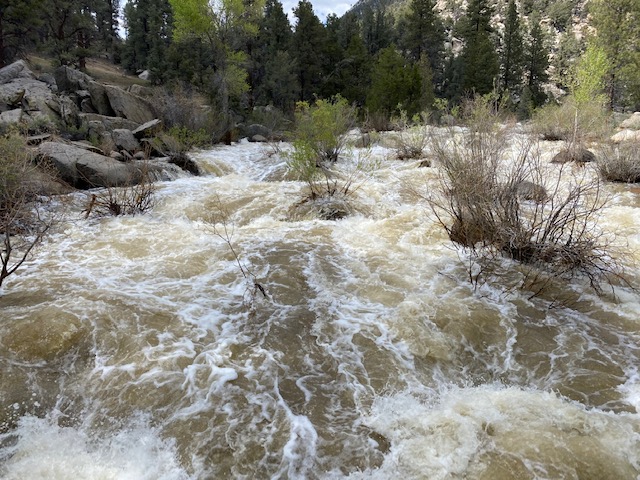
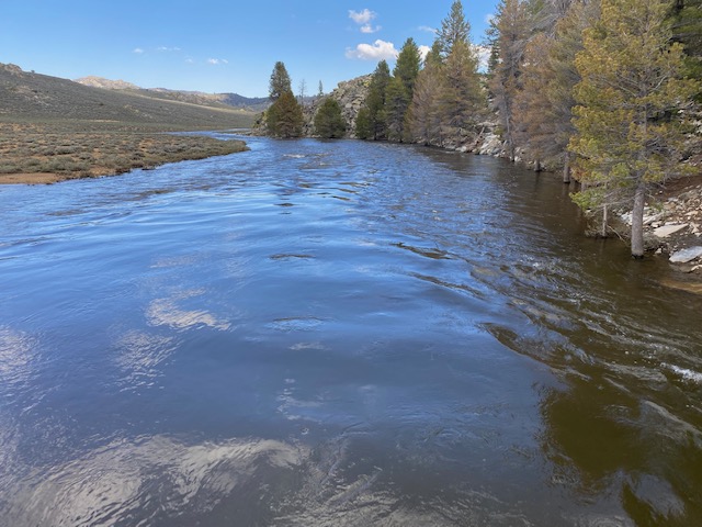
Pacific Crest Trail Conditions along South Fork Kern River
Related Incident: INYO NATIONAL FOREST--FLOOD RESPONSE
Publication Type: Announcement
The Pacific Crest Trail is snow free from Kennedy Meadows, north to Olancha Pass/Summit Meadow area. In the Olancha Pass/Summit Meadow area, there are large patches of snow. Unknown conditions north of there, but the trail climbs in elevation so there is likely to significantly more snow. All creeks are flowing in this section of trail, and there is plenty of water. The South Fork of the Kern River is running VERY high. Both bridges are intact and passable.
See 2 Photos posted under the Photos Tab above and below under related information.
Road to Kennedy Meadows Campground and Tulare County Repair Work Scheduled
Related Incident: INYO NATIONAL FOREST--FLOOD RESPONSE
Publication Type: Announcement
NOTE: Tulare County Road department will be repairing the road into Kennedy Meadows Campground on Tuesday and Wednesday of next week, June 6 and 7. The road will be impassable on the June 6 and hopefully drivable by the afternoon of June 7.
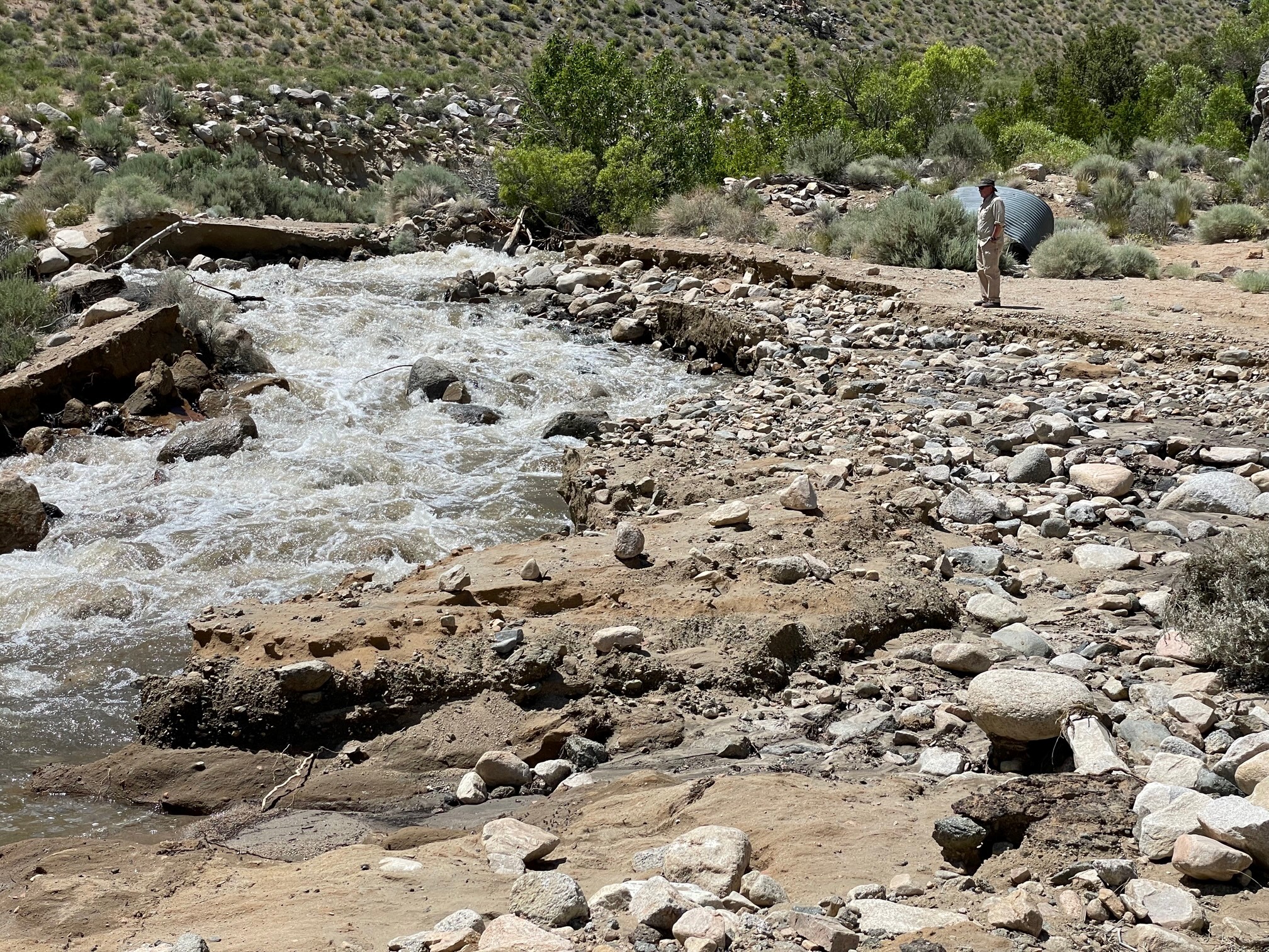
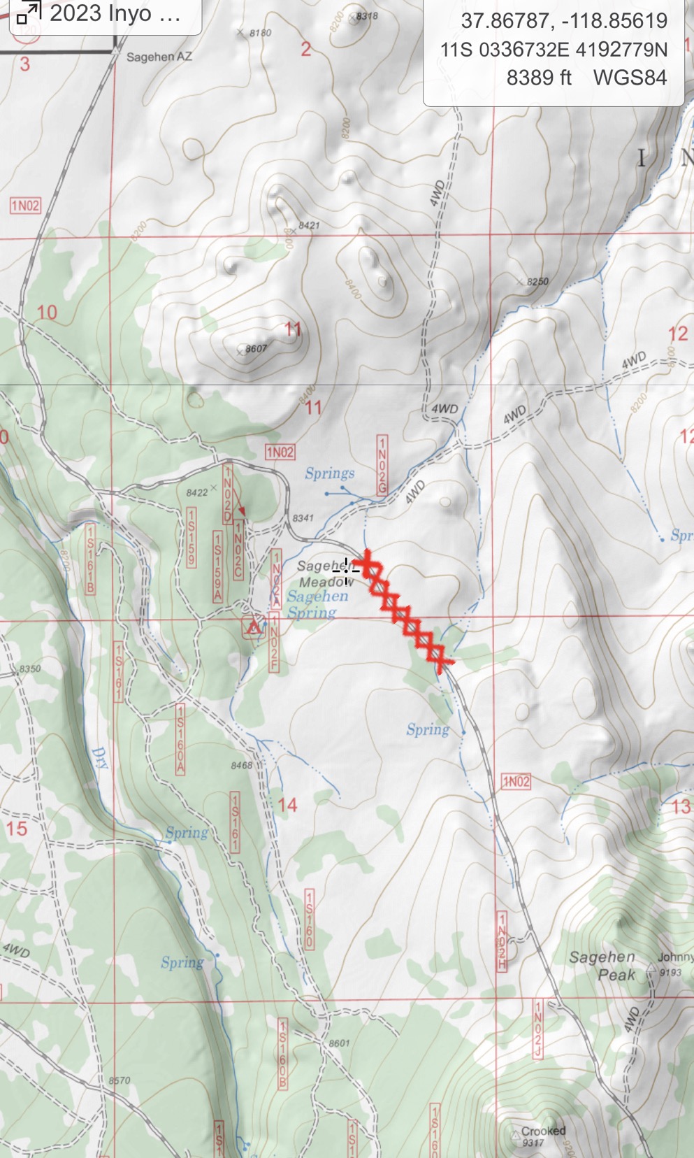
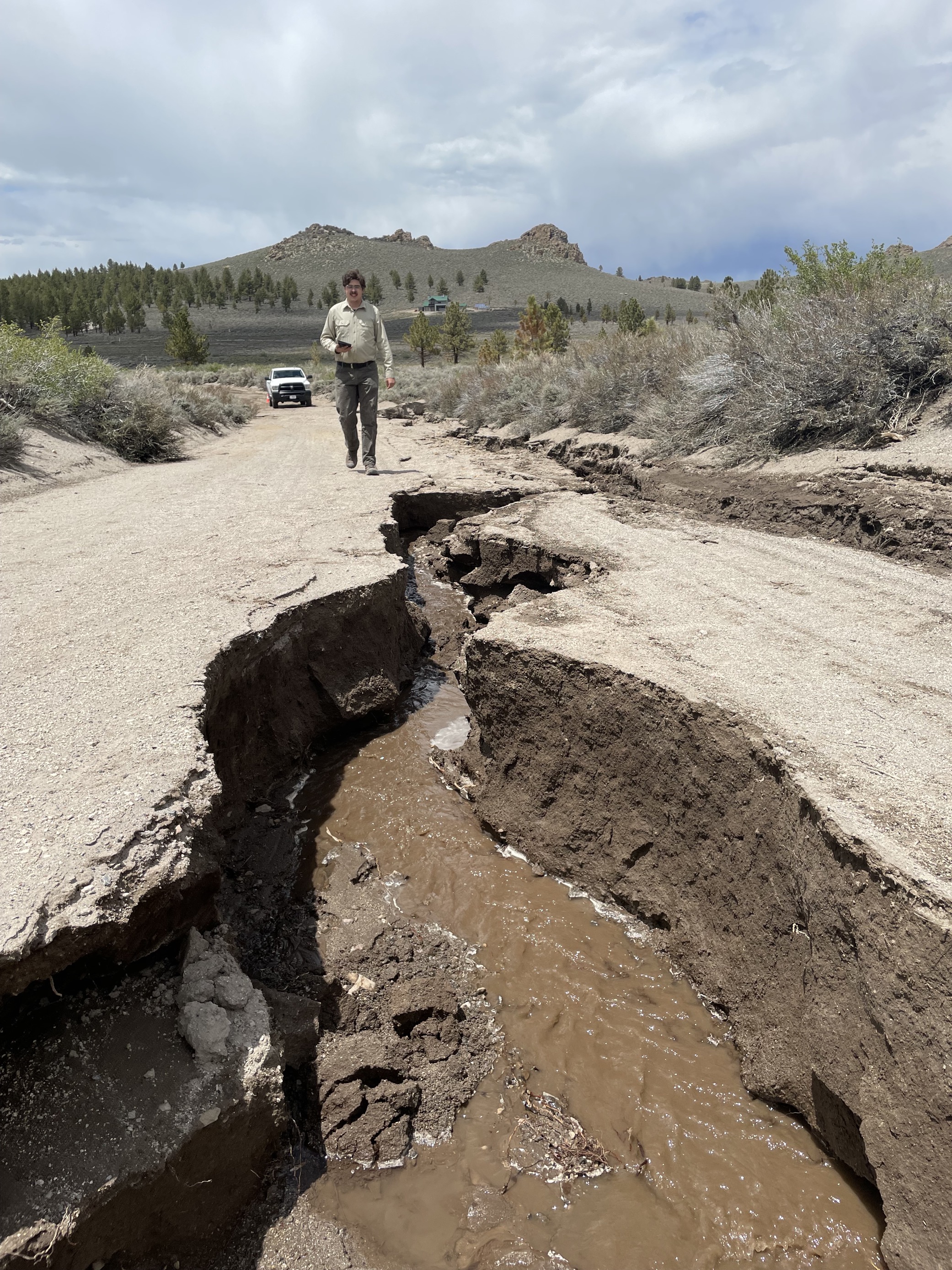
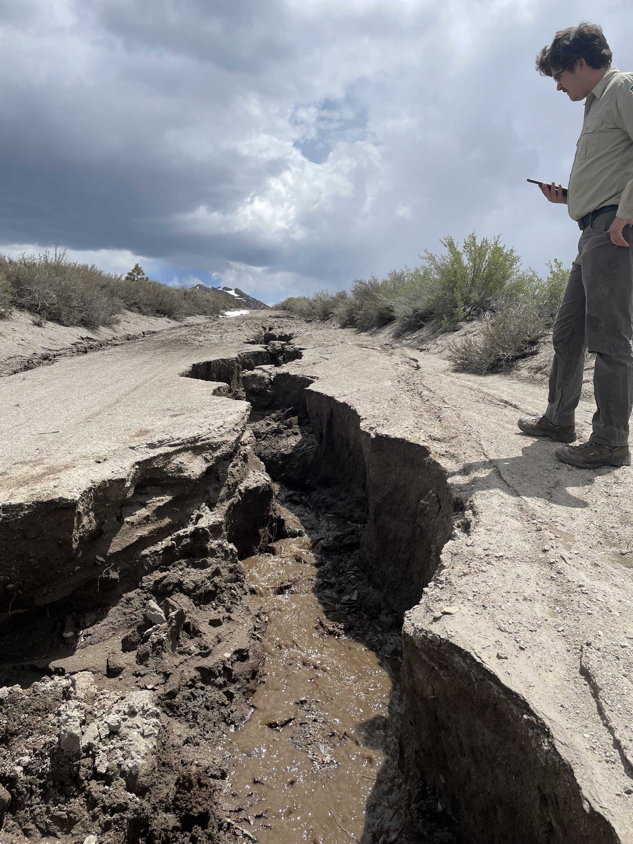
BIG ROAD WASHOUT ALERTFS ROAD 1N02 SAGEHEN MEADOWS
Related Incident: INYO NATIONAL FOREST--FLOOD RESPONSE
Publication Type: Announcement
**BIG ROAD WASHOUT ALERT**
Vehicles NOT recommended on Forest Service Road 1N02 (Sagehen Meadow). See 3 Photos & Map (1-2-3) under Photos Tab above or below under related information.