
20230528PassFireUpdate
Related Incident:
Publication Type: News
TRUTH OR CONSESQUENCES, NM, May 28, 2023 – The Pass Fire on the Gila National Forest, Black Range Ranger District has grown to approximately 9,804 acres since it was ignited by lightning strike May 18. The Gila Las Cruces Zone Type 3 Team, led by Incident Commander Pete Valenzuela assumed command yesterday.
The low to moderate intensity of the Pass Fire allows firefighters time to get out ahead to assess values at risk and prepare holding features and protection before the fire’s arrival. Yesterday, a helispot at Black Mountain was cleared of encroaching vegetation and the Black Mountain Lookout’s cabin was wrapped.
“We’re seeing some really good fire effects, consuming dead grass and pine litter, with heavy dead and down fuels burning down to ash,” said Valenzuela. “Crews are doing a great job of keeping pace with the interior advance of the fire, burning out small pockets of vegetation between the fire and prepared containment features. A variety of tactics will be used to confine and contain the Pass Fire commensurate with firefighter safety, probability of success, and values at risk.”
Weather over the fire area will be mostly sunny today, with highs from 69 to 84, depending on elevation. Relative humidity will drop to 8 - 11%. The fire currently has 115 people responding, including one Bureau of Land Management and two Gila National Forest fire engines, the Gila Regulars and Rio Puerco BLM hand crews, and one Type 3 helicopter in addition to incident command staff. Additional resources have been ordered and the size of the organization is expected to increase in the coming days.
Values at risk include small private land parcels, range fences, water pipelines and stock tanks, powerlines, recreation sites, roads, a research site, historic features, sensitive wildlife habitats, wetlands, and watershed resources. They will be protected as appropriate if fire reaches pre-identified management action points.
The Pass Fire is located south of New Mexico Highway 59, about 1 mile west of Wolf Hollow Campground, and along the northern Gila Wilderness boundary. Camping is not recommended at Wolf Hollow due to the likelihood of fire reaching the area and heavy localized firefighter activity. Please use caution when entering or passing through the area, as heavy firefighter traffic and activity may exist along area roads. Air inversions are likely to cause low-lying smoke to settle into valleys overnight that may obscure visibility for travel. Smoke-sensitive individuals should follow recommendations at NM Fire Info | Smoke Management. More information about the Pass Fire is available at Nmgnf Pass Fire Information | InciWeb (nwcg.gov) and on New Mexico Fire Information at NM Fire Info | New Mexico Fire Information For more information contact Maribeth Pecotte at 575-388-8211 or Maribeth.Pecotte@usda.gov.
20230527PassFireUpdate
Related Incident:
Publication Type: News
TRUTH OR CONSESQUENCES, NM, May 27, 2023 – The Pass Fire on the Gila National Forest, Black Range Ranger District has grown to approximately 8,261 acres over the past 9 days. The Gila Las Cruces Zone Type 3 Team, led by Incident Commander Pete Valenzuela assumed command this morning.
The fire is located south of New Mexico Highway 59, about 1 mile west of Wolf Hollow Campground, and along the northern Gila Wilderness boundary. Camping is not recommended at Wolf Hollow due to the likelihood of fire reaching the area and heavy localized firefighter activity. Fire is progressing to the south, east, and west, consuming mostly down logs, dead grass, and pine needles beneath a ponderosa pine-dominated forest canopy.
One hundred people are currently working the Pass Fire, including a large number of youths who are supporting the fire at the Incident Command Post, gaining work experience and exposure to public land management. A Job Corps kitchen crew began serving meals this morning and camp yurts are being maintained by a contracted youth crew out of California. Fire crews are cutting back grass and removing surface fuels to protect range and other infrastructure. A Helitack crew will begin cleaning up a helispot on Black Mountain in preparation for structure protection of Black Mountain Lookout.
“Responders have done some great work up to now, protecting values at risk and keeping the fire south of Highway 59, while allowing fire to play its natural role in the forest,” said Valenzuela. “The work we’re doing is helping to restore resiliency to these lands and watersheds.”
A variety of tactics will be used commensurate with public and firefighter safety, values at risk, and likelihood of success. Values at risk include small private land parcels, range fences, water pipelines and stock tanks, powerlines, recreation sites, roads, a research site, historic features, sensitive wildlife habitats, wetlands, and watershed resources. They will be protected as appropriate if fire reaches pre-identified management action points.
Firefighters are using control elements, such as roads, trails and landscape features to safely confine and contain the fire within the desired area identified by resource specialists. A large planning area allows for the Pass Fire to ultimately encompass about 75,000 acres south of Highway 59, including much of the northern Gila Wilderness east of Indian Creek, north of the Middle Fork Gila River and the Adobe Springs and White Rocks trails, and west of the East Fork Gila River and Beaver Creek.
Decisions about whether to fully suppress a naturally ignited wildfire or to manage for natural resource objectives depend on a number of factors including the ignition source, location, fuels, suppression resource availability, expected fire weather conditions, and seasonal outlook.
Weather over the fire area will be partly cloudy this morning, turning mostly sunny this afternoon, with highs from 68 to 83, depending on elevation. Relative humidity will drop to 10 to 15% this afternoon, and there’s a 10% chance of precipitation today.
Several fire scars exist around the area of the Pass Fire, which will help serve as containment features, should the fire reach them. Pass Fire ignited within the 2005 Bull Fire perimeter, which removed a large amount of ladder fuels from much of the area. The 2012 Whitewater Baldy fire scar is a few miles west of the western edge of the Pass Fire, and the more distant 2021 Johnson Fire and 2022 Black Fire scars lie to the south and east.
Please use caution when entering or passing through the area, as heavy firefighter traffic and activity may exist along area roads. Air inversions are likely to cause low-lying smoke to settle into valleys overnight that may obscure visibility for travel. Smoke-sensitive individuals should follow recommendations at NM Fire Info | Smoke Management. More information about the Pass Fire is available at Nmgnf Pass Fire Information | InciWeb (nwcg.gov) and on New Mexico Fire Information at | Fire crews responding to Pass Fire near Indian Creek CabinNM Fire Info For more information contact Maribeth Pecotte at 575-388-8211 or Maribeth.Pecotte@usda.gov.
Ignitions Planned to Continue at Van Bremmer on Saturday May 27
Related Incident: 2023 Klamath National Forest Spring Prescribed Burning
Publication Type: News
***UPDATE*** Due to unfavorable conditions at the Van Bremmer prescribed burn Saturday morning, no ignitions will be taking place today. Resources will remain at the project today to patrol yesterday's burn.
---
Fire personnel on the Goosenest Ranger District had a successful day at the Van Bremmer prescribed burn on Friday, completing 45 acres of burning.
Ignitions are planned to continue Saturday, as weather conditions permit. Up to 175 acres of burning may occur.
Goals of the Van Bremmer Project are to reduce hazardous fuels to decrease fire behavior during future wildfire events, improve forage for big game, and to improve stand resilience to insects and disease.
Prescribed fire is implemented under a predetermined specific set of weather and fuels parameters that is described within the approved burn plan for that project. This allows fire managers to reintroduce fire when conditions are optimal for desired results.
The Van Bremmer Project is located about nine miles northeast of Tennant, on the east side of the Klamath National Forest. Smoke may be visible from CA Highway 97.
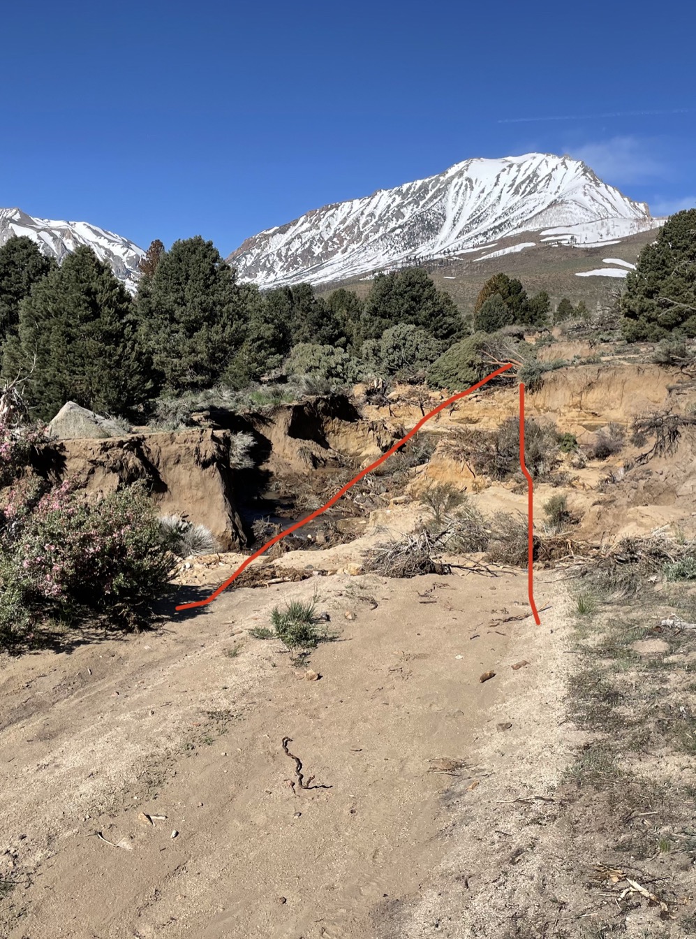
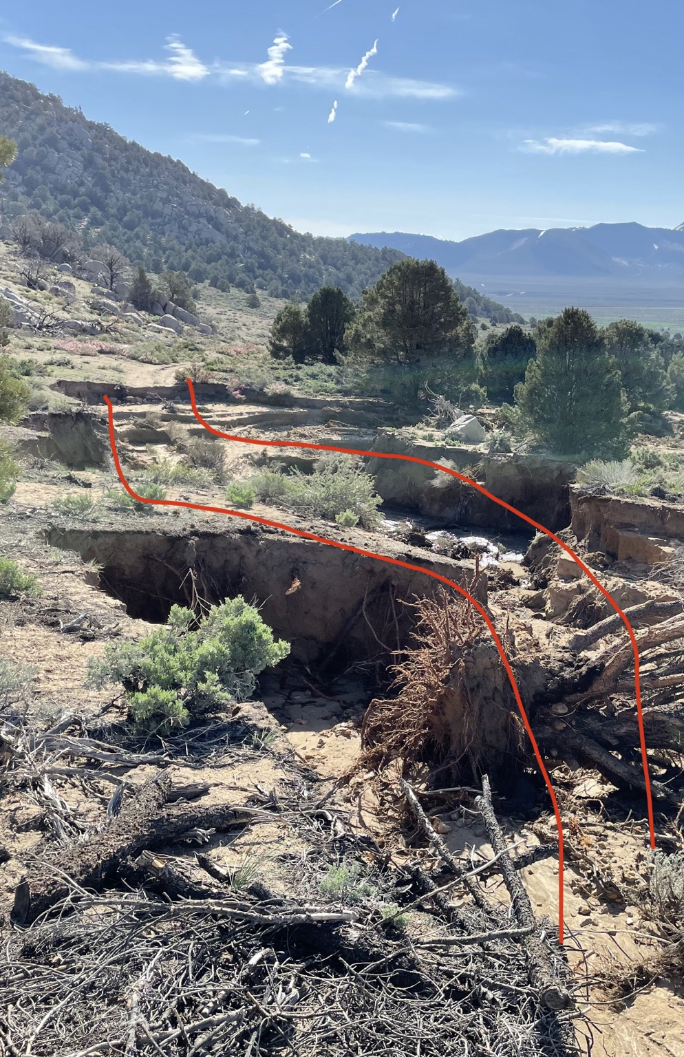
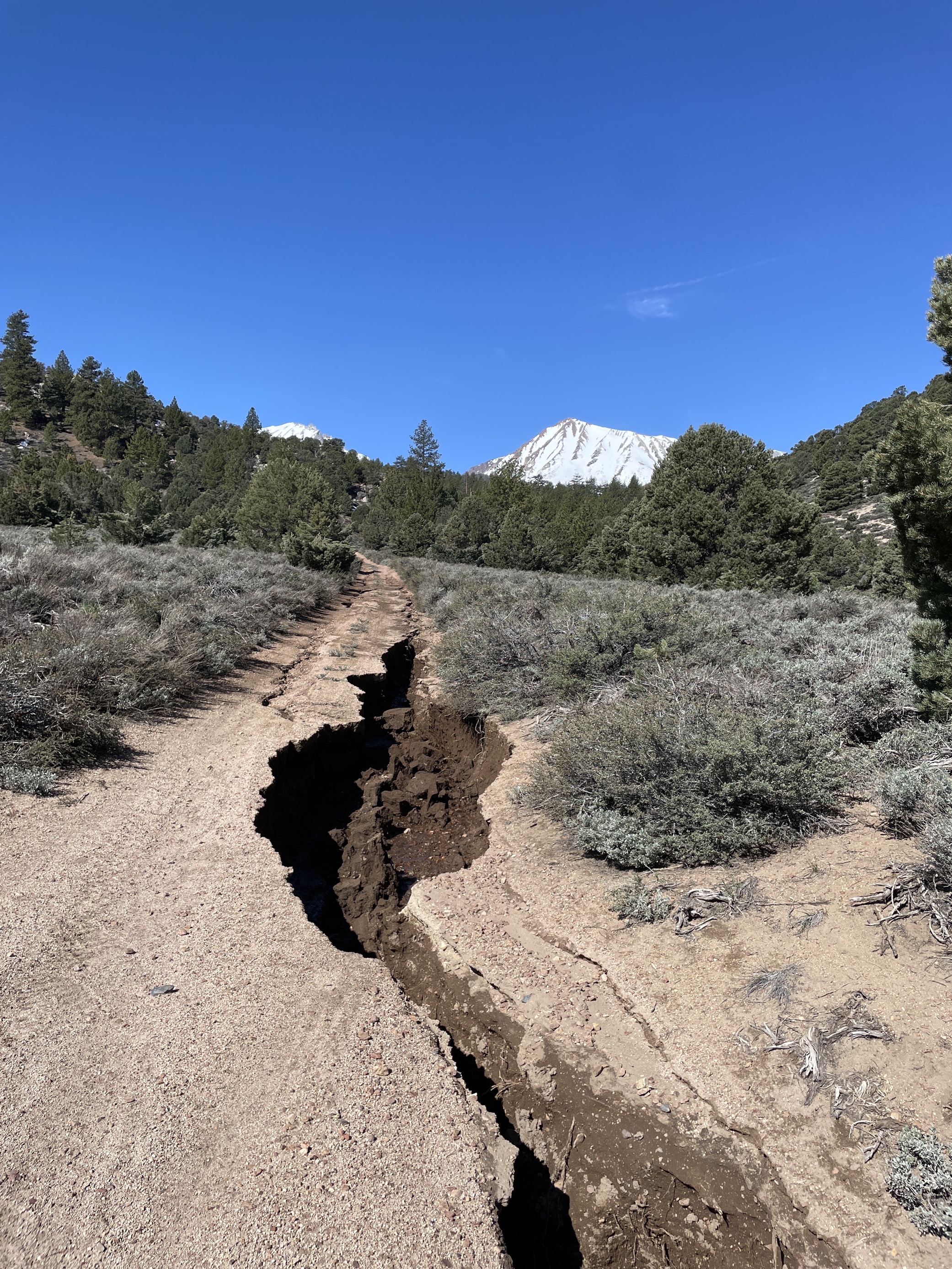
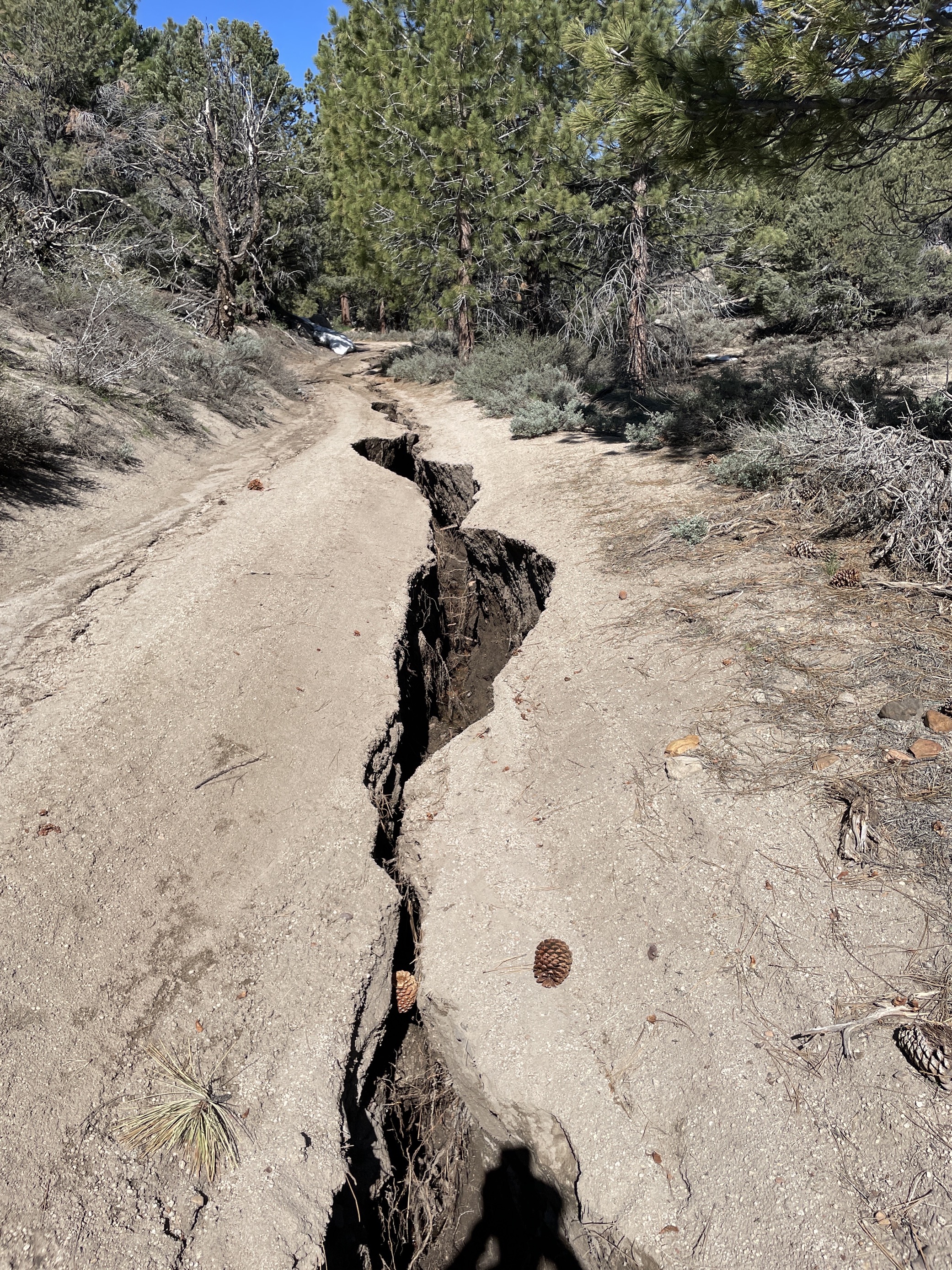
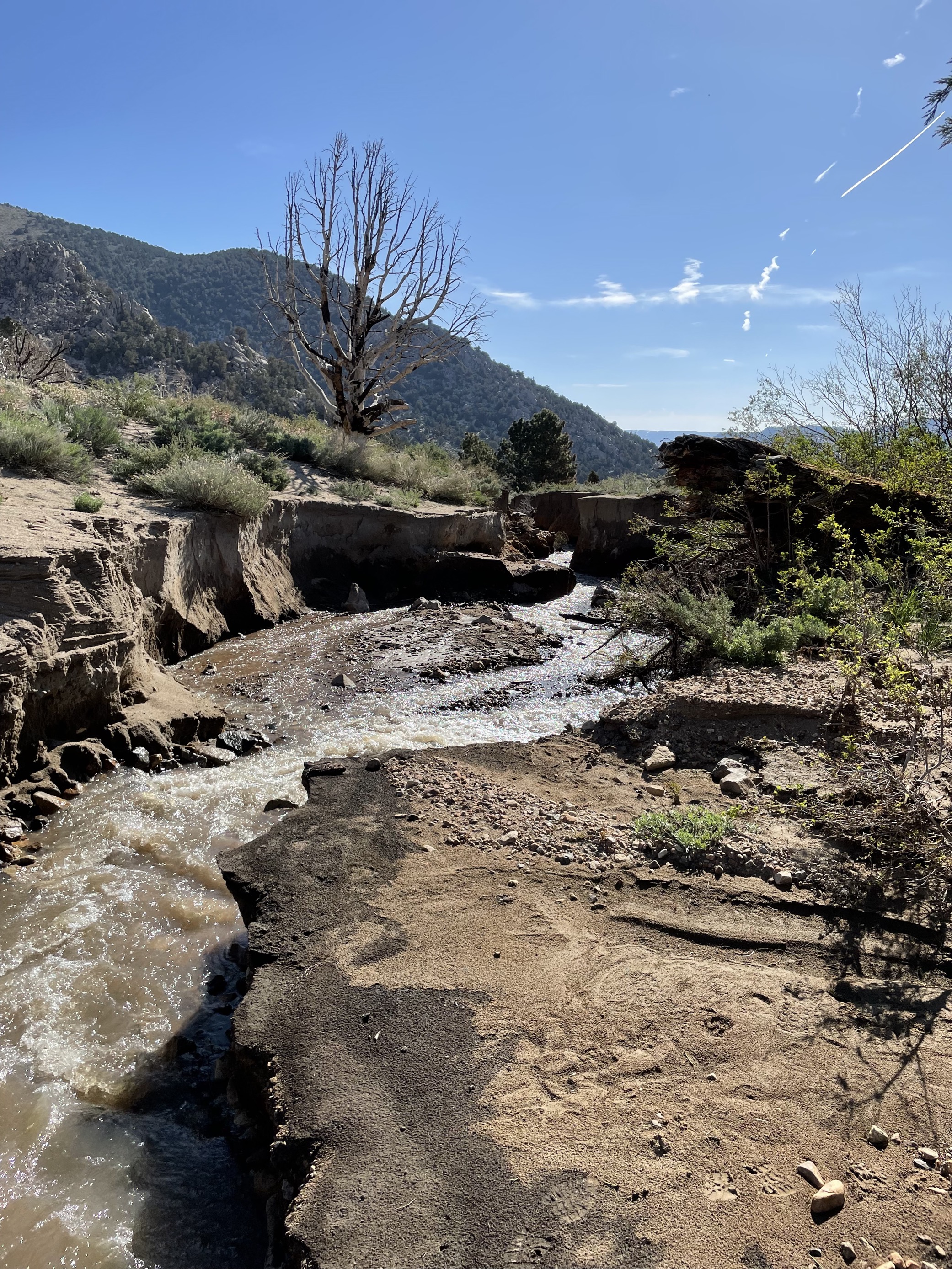
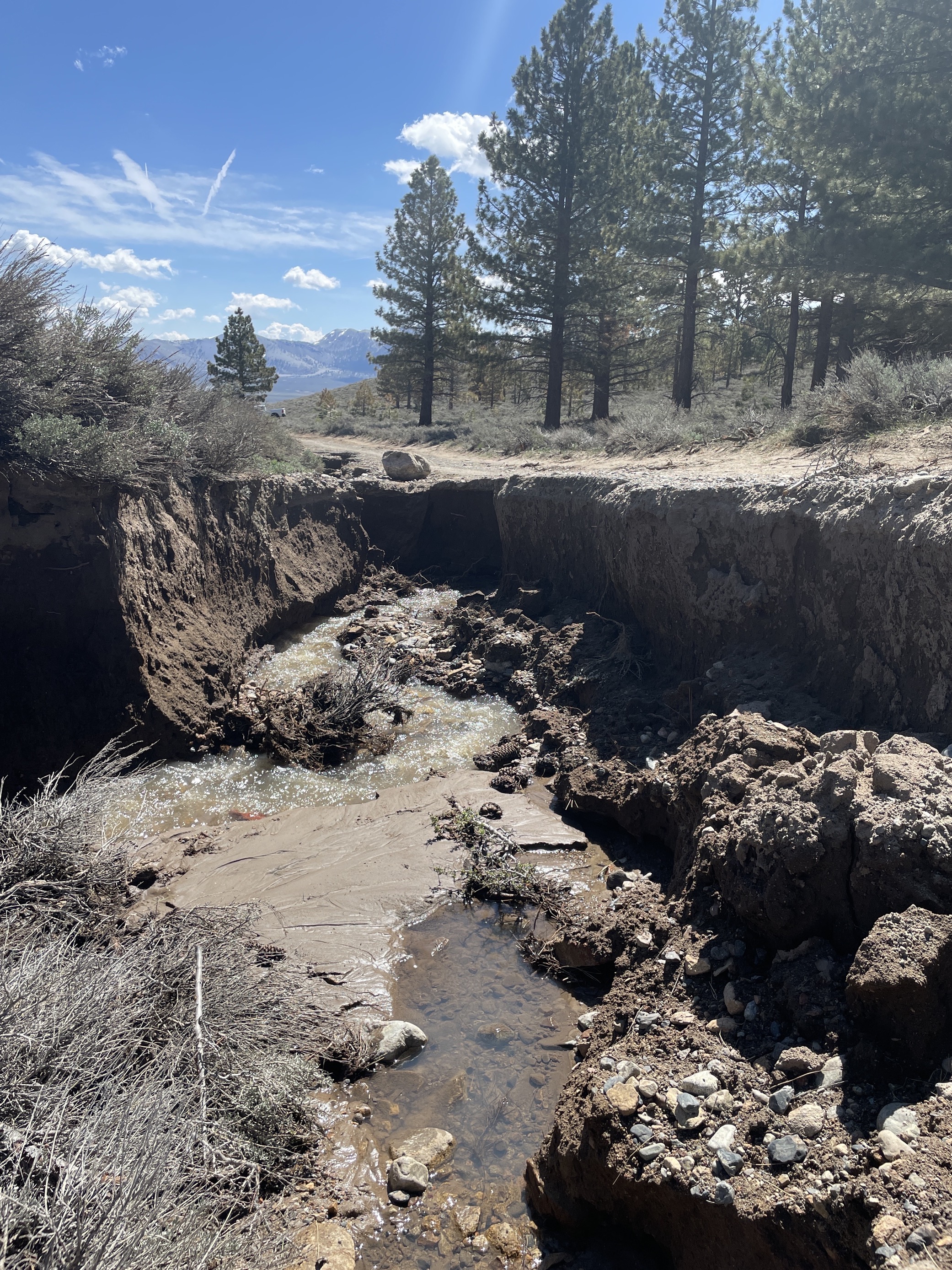
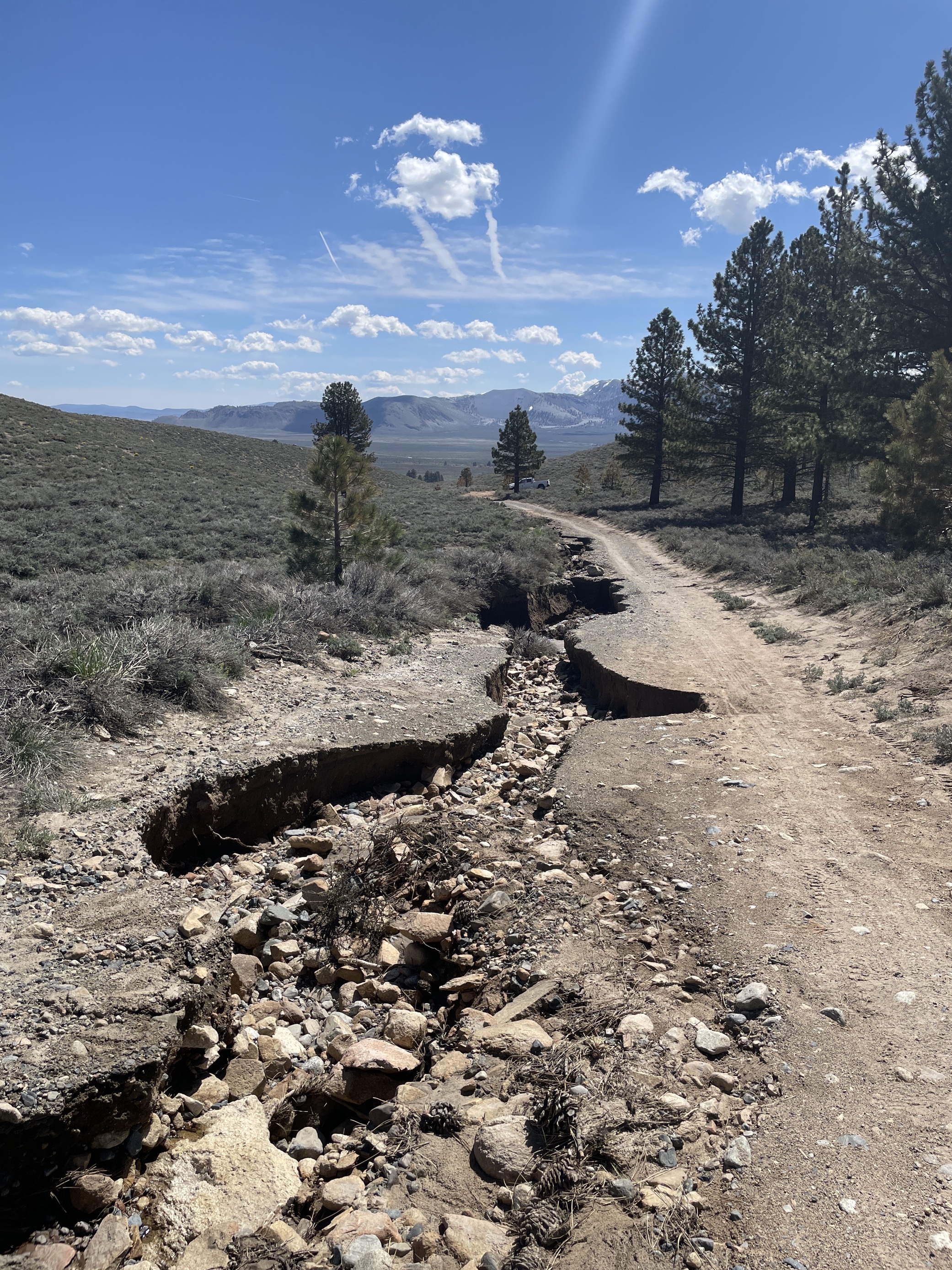
Gibbs Lake Trailhead Photos Showing Road Conditions
Related Incident: INYO NATIONAL FOREST--FLOOD RESPONSE
Publication Type: Announcement
On the Photos Tab at the top are 5 photos showing that both roads to the Gibbs Lake Trailhead (Bohler Canyon 1N106 and Horse Meadow 1N16) are washed out and impassable to vehicles at this time.
See photos 7-8-9-10-11 called GIBBS LAKE TRAILHEAD ROAD PHOTOS
Also see 7-8-9-10-11 Road Photos below under related information.
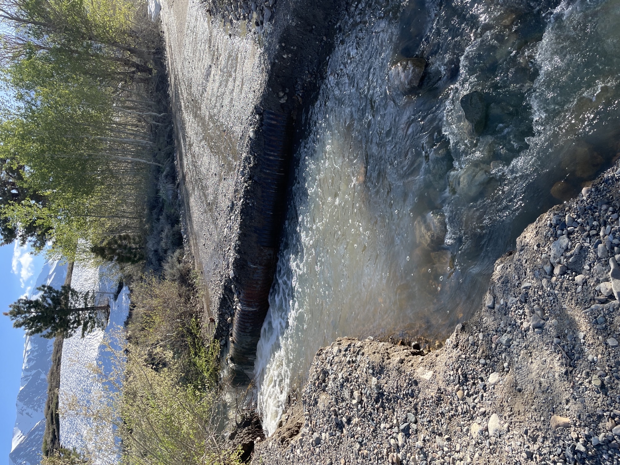
Sawmill Canyon Photos Showing Road Conditions
Related Incident: INYO NATIONAL FOREST--FLOOD RESPONSE
Publication Type: Announcement
On the Photos Tab at the top are 2 photos showing current conditions for Sawmill Canyon Road (1S23 to Walker Lake/Bloody Canyon Trailhead) which has a failed culvert and washout located about 2 miles from the trailhead and is NOT recommended for vehicles.
See 5&6 photos called SAWMILL CANYON ROAD.
Also see 5&6 Road Photos below under related information.
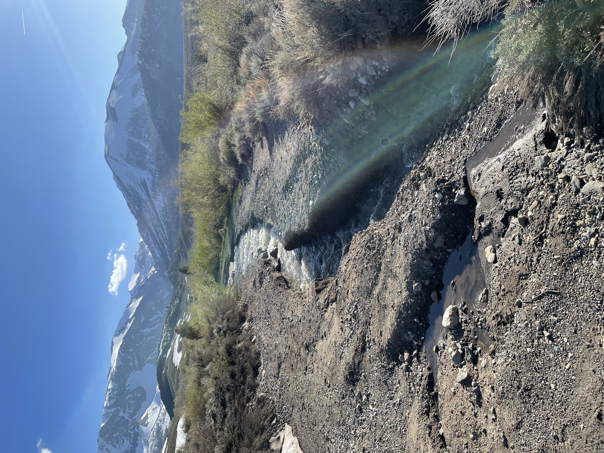
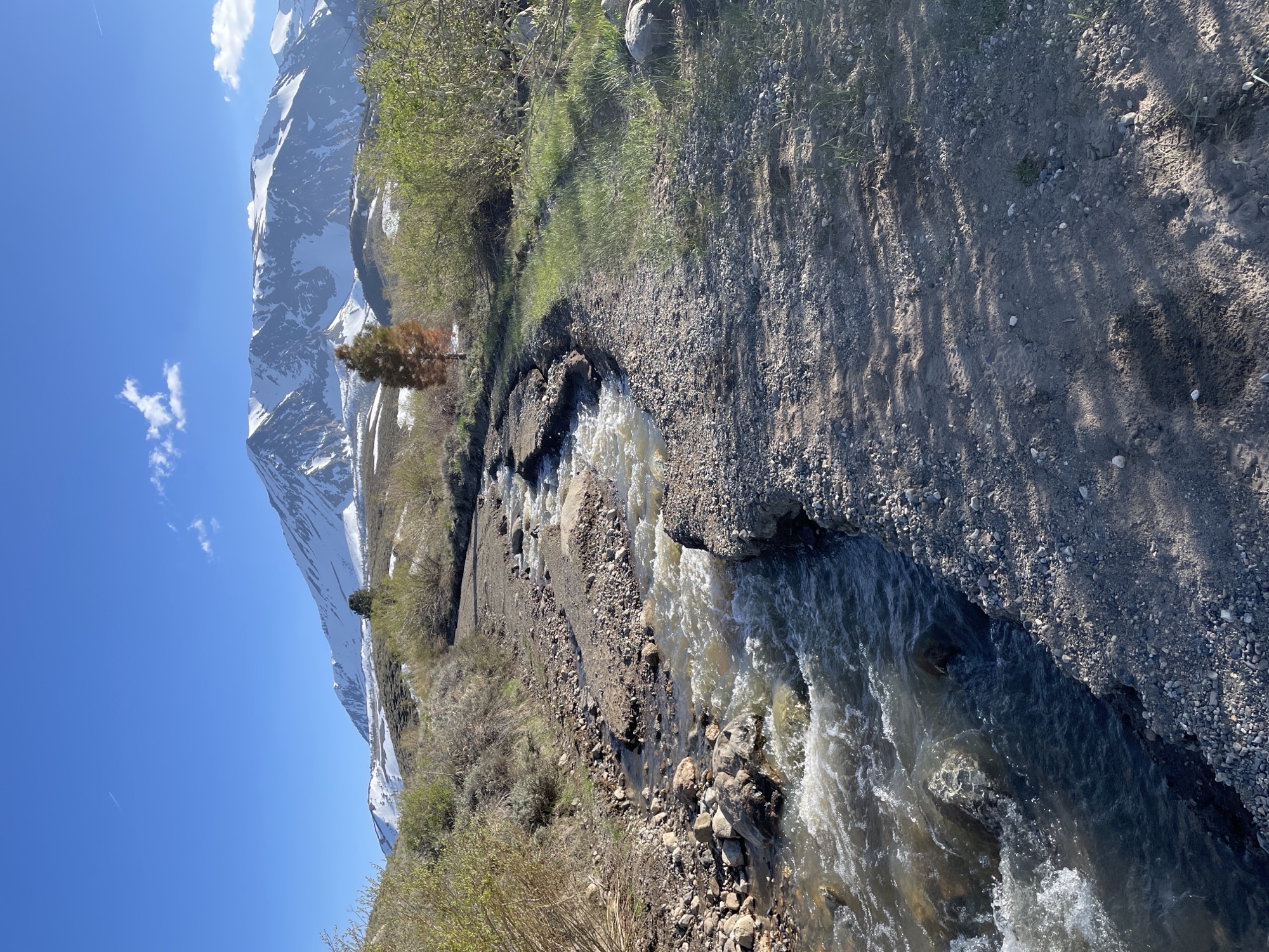
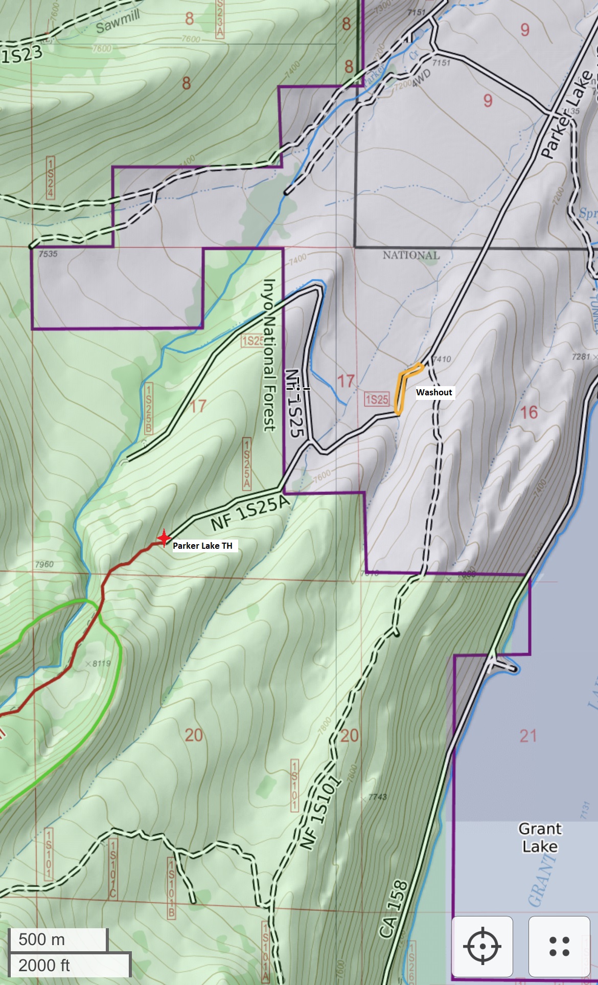
Parker Lake Trailhead Photos Showing Current Road Conditions
Related Incident: INYO NATIONAL FOREST--FLOOD RESPONSE
Publication Type: Announcement
On the Photos Tab at the top are 3 photos and 1 map showing road conditions to the Parker Lake Trailhead are currently inaccessible to vehicles due to a blown culvert and washout on Parker Lake Road (1S25) about a mile from the trailhead. This is on LADWP land. There are signs warning motorists of flooding.
See 1-2-3-4 photos called PARKER LAKE TRAILHEAD PHOTOS.
Also see 1-2-3-4 Road Photos below under related information.
Central CA PCT Closure Information for Damaged SF San Joaquin River Bridge
Related Incident: INYO NATIONAL FOREST--FLOOD RESPONSE
Publication Type: Announcement
Detailed detour information for the South Fork of San Joaquin River Bridge can be found here: South Fork San Joaquin River Bridge damaged - Pacific Crest Trail Association (pcta.org).
National Park Service Plans to Conduct Prescribed Fire at El Malpais National Monument
Related Incident:
Publication Type: News
Grants, NM – El Malpais National Monument is preparing to conduct a prescribed fire on the north side of the monument adjacent to Highway 53 between mile marker 65 and 68. The primary objective of this prescribed fire is to improve forest health by reducing the build-up of vegetation that can fuel a wildfire. Fire plays a natural role at El Malpais and helps ensure the resiliency of this fire dependent ecosystem.
The Lava Fields prescribed fire will treat approximately 1,000 acres of NPS lands. This operation is tentatively scheduled for the week of May 29th and fire managers expect that the operation will take four to five days to complete. Ignitions are expected to begin late morning into midday and continue into the afternoon each day. Exact dates and times can change dependent on weather and fuel conditions. Firefighters will monitor the area after ignitions are complete.
Smoke will be most visible on days when burning occurs, mostly during the warmest part of the day. With cooler temperatures in the evening, smoke may linger in low-lying areas for a few days after burn operations are complete.
The El Calderon Road (NPS 100 Road), and all caves and trails (including the Continental Divide Trail which will be temporarily re-routed) in the area will be closed to non-resident traffic during the ignition phase until it is deemed safe to re-open. If conditions warrant, a pilot car may be used along Hwy 53. Please slow down, turn your headlights on, and watch for firefighters working along the roadway when traveling in this area.
For questions about the prescribed fire call the El Malpais National Monument Visitor Center at (505) 876-2783.
Fire information will also be available on https://inciweb.nwcg.gov and http://nmfireinfo.com. Learn more about what’s involved in planning and implementing a prescribed fire at https://www.nps.gov/subjects/fire/index.htm.
-NPS-
20230526PassFireUpdate
Related Incident:
Publication Type: News
TRUTH OR CONSESQUENCES, NM, May 26, 2023 – The Pass Fire on the Gila National Forest, Black Range Ranger District has grown to approximately 7,261 acres since it ignited May 18. It is currently located south of New Mexico Highway 59, about 1.5 miles west of Wolf Hollow Campground, and along the northern Gila Wilderness boundary. A Type 3 Incident Management Team will assume command of the fire tomorrow morning.
“We are allowing fire to play its natural role in this fire-dependent ecosystem, while protecting firefighter and public safety, infrastructure, and other values at risk,” said Agency Administrator Elizabeth Toney. “The fire burned fairly quickly through continuous grass across Cooney Prairie, and is currently creeping through pine understory, backing down slopes and occasionally torching in regenerating junipers.”
Ponderosa pine forests in the Southwest were sculpted by frequent, low-to-moderate fire conditions that promoted open, multi-aged stands on a diverse landscape with variable fuels that resisted large continuous fires. A century of wildland fire suppression has altered the composition of forests in the Southwest in a way that promotes high-intensity, large-scale fires. There is a critical need for low to moderate-intensity fire to be allowed to return to these forests, at a pace and scale that we have not experienced in our lifetimes.
Firefighters are using control elements, such as roads, trails and landscape features to prevent damage to infrastructure and keep the fire within a pre-identified area. They are currently removing fuels around Wolf Hollow Campground and Trailhead. It is not recommended to camp at Wolf Hollow due to the likelihood of fire reaching the area and heavy localized firefighter activity.
Functional fences and other range infrastructure have been identified and protected from burning by fire crews where possible, by pulling fuels away from wooden fenceposts and stays and running weed-eaters. Small burnout operations have been and will continue to be used to consume fuels and establish containment line around the historic Indian Creek Cabin and along the south side of Highway 59. Using fire in this way allows crews to safely engage the fire on their terms and timeline, directing it around or away from values at risk.
Several fire scars exist around the area of the Pass Fire, which will help serve as containment features, should the fire reach them. Pass Fire ignited within the 2009 Bull Fire perimeter, which removed a large amount of ladder fuels from much of the area. The 2012 Whitewater Baldy fire scar is a few miles west of the western edge of the Pass Fire, and the more distant 2021 Johnson Fire and 2022 Black Fire scars lie to the south and east.
Limited values at risk in the area will be protected as appropriate if fire reaches pre-identified management action points. The large planning area allows for the Pass Fire to ultimately encompass about 75,000 acres south of Highway 59, including much of the northern Gila Wilderness east of Indian Creek, north of the Middle Fork Gila River and the Adobe Springs and White Rocks trails, and west of the East Fork Gila River and Beaver Creek.
Please use caution when entering or passing through the area, as heavy firefighter traffic and activity may exist along area roads. Air inversions are likely to cause low-lying smoke to settle into valleys overnight that may obscure visibility for travel. Smoke has been observed in Indian Creek and the Gila River drainages, impacting the Gila Cliff Dwelling National Monument, area campgrounds, and residential areas near Gila Hot Springs. Smoke-sensitive individuals should follow recommendations at NM Fire Info | Smoke Management.
More information about the Pass Fire is available at Nmgnf Pass Fire Information | InciWeb (nwcg.gov) and on New Mexico Fire Information at | Fire crews responding to Pass Fire near Indian Creek CabinNM Fire Info For more information contact Maribeth Pecotte at 575-388-8211 or Maribeth.Pecotte@usda.gov.
###
USDA Forest Service is an equal opportunity provider, employer, and lender.
Great Lakes Fire Update Friday May 26 2023 Final
Related Incident: Great Lakes
Publication Type: News
Phone: 252-638-5628
Croatan National Forest Web: www.fs.usda.gov/nfsnc Facebook: https://www.facebook.com/nfsnc
PLEASE BE AWARE: Wildland fire engines and other equipment continue to be on roads in the fire area and on US Hwy 70 between Havelock and New Bern. Please use caution when driving near them.
Acreage: 32,156 acres; Containment: 90%; Personnel and Equipment: 80 total personnel; 1 helicopter, 3 engines, 1 water tender, and 2 tractor plow units.
Today: The North Carolina Type III team will transition with the Croatan Ranger District on Monday, May 29thand will be returning to their home units. “We deeply appreciate the cooperation, patience and support the community has demonstrated during this incident - it has been outstanding, and we sincerely thank you!” noted David McFee, the incident commander of the NC Type III team. After the transition, aviation and ground resources will continue to monitor fire activity to identify hot spots and any areas of concern and crews and equipment will continue their efforts in rehabilitation and repair work to minimize impacts associated with suppression activities. Road repair work now underway includes the following:
FS 203 – Holston Creek Road FS 203 – Holston Creek Road
FS 134 – Holston Hunter Trail FS 606 – Mattocks Road
FS 3070 – Cow Pond Road FS 121 -1 – North Little Road
FS 163 – Belangia Road FS 121- 2 – Middle Little Road
FS 126 – Holston Hunter Road FS 158 – Catfish Lake Farm Road
FS 172 - Mirey Branch Road
Repair will continue over the next several months. “We are asking the public to avoid using these roads while repairs are underway so the work can be performed safely and expeditiously,” stated Ron Hudson, District Ranger for the Croatan.
Special Note: THIS WILL BE THE FINAL UPDATE ISSUED BY THE NORTH CAROLINA TYPE III INCIDNET MANAGEMENT TEAM
Closure Orders in Effect: Forest Service Road 174 (Seaborn Road), and Forest Service Road 126 (Great Lake Road) remain closed due to fire equipment and operations.