
May 31 Lava Fields Prescribed Fire Update Archive
Related Incident:
Publication Type: News
Wednesday, May 31 Update, 10:00 a.m.
Crews successfully completed approximately 500 acres of the Lava Fields Prescribed Fire in El Malpais National Monument yesterday. Conditions are favorable to continue operations today. Ignitions are expected to begin mid-morning and continue into the afternoon.
Smoke and flames may be visible in the Highway 53 corridor. Motorists are urged to slow down, turn on their headlights, and be aware of firefighters that may be working along the roadway. If conditions warrant, a pilot car may be used along Hwy 53. The El Calderon Road (NPS 100 Road), and all caves and trails (including the Continental Divide Trail, which will be temporarily re-routed) in the area will be closed to non-resident traffic during ignitions.
Prescribed fire operations began on May 30 and fire managers expect that the operation will take four to five days to complete. Ignitions are expected to begin late morning into midday and continue into the afternoon each day. If conditions are not right, operations may be delayed until the weather or fuels are right to achieve the desired effects on the land. Firefighters will monitor the area after ignitions are complete.
Smoke will be most visible on days when burning occurs, mostly during the warmest part of the day. With cooler temperatures in the evening, smoke may linger in low-lying areas for a few days after burn operations are complete.
El Malpais is a fire dependent ecosystem. Land managers use prescribed fire to reduce hazardous fuel loads, manage landscapes, and achieve ecological benefits. The Lava Fields prescribed fire will treat approximately 1,000 acres of NPS lands.
For questions about the prescribed fire call the El Malpais National Monument Visitor Center at (505) 876-2783.
20230601PassFireUpdate
Related Incident:
Publication Type: News
Acres: 17,282 acres
Location: 40 miles west of Winston, NM
Containment: 0%
Personnel: 151
Start Date: May 18, 2023
Cause: Lightning
Fuels: Timber and grass
The Pass Fire behavior has been low to moderate. This activity is characterized by creeping, with generally low flame lengths on the surface of the forest. There can also be individual tree torching. A fire of this quality is regarded as beneficial to the environment, reducing hazardous fuels, invasive and non-native species, while increasing grasses and forage after the fire has passed.
Fire crews began firing operations along Highway 59 and worked to the east. The operation was successful and created a wide fireline to prevent further movement to the north. Because of the additional burning, smoke has increased significantly and air quality has decreased in some areas. Please refer to airnow.gov for smoke conditions and recommendations for your area. Firing will continue today south of Black Mountain.
The southern portion of the fire has spread onto the Gila Wilderness.
A protection plan is being developed to assess private lands, infrastructure in the vicinity and included values-at-risk of Threatened & Endangered species in Beaver Creek.
Weather: Cooler weather conditions are expected with temperatures of 63-77 degrees. Winds will be 10-15 mph out of the southwest. There is no chance of precipitation at this time, but relative humidity is higher.
Aviation Restrictions: Temporary Flight Restriction (TFR) has been established over the Pass Fire. A “TFR” restricts non-fire aircraft from flying over the fire area. This includes civilian drones. Unauthorized aircraft in the area can ground firefighting aircraft and hindering firefighting efforts.
Closures: There are no road closures at this time and Gila National Forest campgrounds are still open. Visitors are encouraged to be aware of firefighting equipment on the roads. Smoke can hinder visibility. They are requested to slow down and watch for hazards as they drive through the area and along Highway 59.
For More Information:
- Inciweb: https://inciweb.wildfire.gov/incident-information/nmgnf-pass-fire Inciweb is the official site for fire information. The site is secure and updated daily.
- New Mexico Fire Information: https://nmfireinfo.com/
- Facebook: https://www.facebook.com/GilaNForest
- Firewise: https://emnrd.nm.gov/sfd/fire-prevention-programs/firewise-usa/
- Air Quality: https://wwwairnow.gov
NATIONAL WEATHER SERVICE UPDATEMAY 31
Related Incident: INYO NATIONAL FOREST--FLOOD RESPONSE
Publication Type: News
NATIONAL WEATHER SERVICE UPDATE--MAY 31
Weather Forecast for Mammoth Area and Mono County:
https://forecast.weather.gov/MapClick.php?lat=37.6488&lon=-118.9779#.ZGWDDHbMI2y
National Weather Service-(NWS) Reno Office:
Thunderstorms Return Today, Possible Flooding Concerns
A sunny start to the day could be lulling us into thinking we have a decent day ahead, but the storms will return. Sunshine will amplify storm initiation, so this works in favor of the storms later this afternoon. Get any outdoor projects or recreation done early today before storms begin to pop. When Thunder Roars, Go Indoors! As in recent days, storms could produce brief heavy rainfall that may result in localized flooding impacts. This trend continues into the end of the week, with a slight bit of relief from the active weather appearing for the weekend.
KEY POINTS
- 30-50% chance of showers and storms for today, chances decrease to 20-40% for tomorrow.
- Cooler temperatures have slowed flooding areawide, potential for flash flooding associated with storms.
- Storms on the decline toward the weekend, but chances ramp up again for next week.
WEATHER RISK OUTLOOK
Risk levels incorporate potential impacts from weather hazards and likelihood of occurrence for a reasonable worst-case scenario. SEE IMAGE BELOW UNDER RELATED LINKS & ABOVE AT PHOTOS TAB.
DETAILS
- Showers and Storms Today: Scattered thunderstorms expected this afternoon (30-50% chance), but less numerous. Saturated grounds and high flows will maintain isolated flash flooding concerns, but limiting factor will be reduced thunderstorm coverage today and beyond.
- Snowmelt River Flooding: Cooler temperatures have reduced snowmelt rates areawide, but the East Fork/Mainstem Walker River will continue to see moderate flooding. The Carson River system continues to see minor impacts mainly in agriculture and open space areas. Keep a close eye on Humboldt River this week with rises working their way down towards Winnemucca and Imlay.
- Remainder of the Week: Storm chances wane each day this week, lowest Friday into the weekend. Longer range outlooks favor increased chances for showers and thunderstorms again early next week.
FOR MORE INFORMATION
For the latest forecast updates, visit weather.gov/reno.
See NWS-Reno Office briefing weather documents below attached under related information.
INYO COUNTY ROADS STATUS UPDATEJUNE 6
Related Incident: INYO NATIONAL FOREST--FLOOD RESPONSE
Publication Type: News
INYO COUNTY ROADS STATUS UPDATE-MAY 31
See attached “Inyo County Roads Update-JUNE 6” attached below under related information.
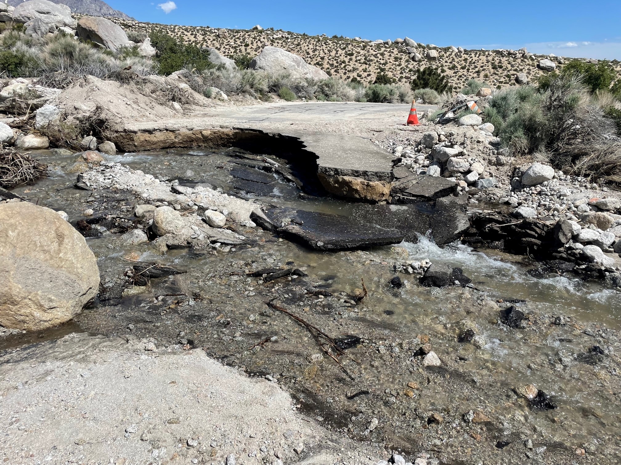
May 30 Road Conditions to Lone Pine CampgroundPhoto
Related Incident: INYO NATIONAL FOREST--FLOOD RESPONSE
Publication Type: Announcement
The road to Lone Pine Campground--May 30 Photo
See photo at the top Photos Tab called ROAD TO LONE PINE
Also see photo below under related information
PUBLIC SAFETY ALERTSTAY OUT OF COLD SWIFT FLOWING WATER
Related Incident: INYO NATIONAL FOREST--FLOOD RESPONSE
Publication Type: Announcement
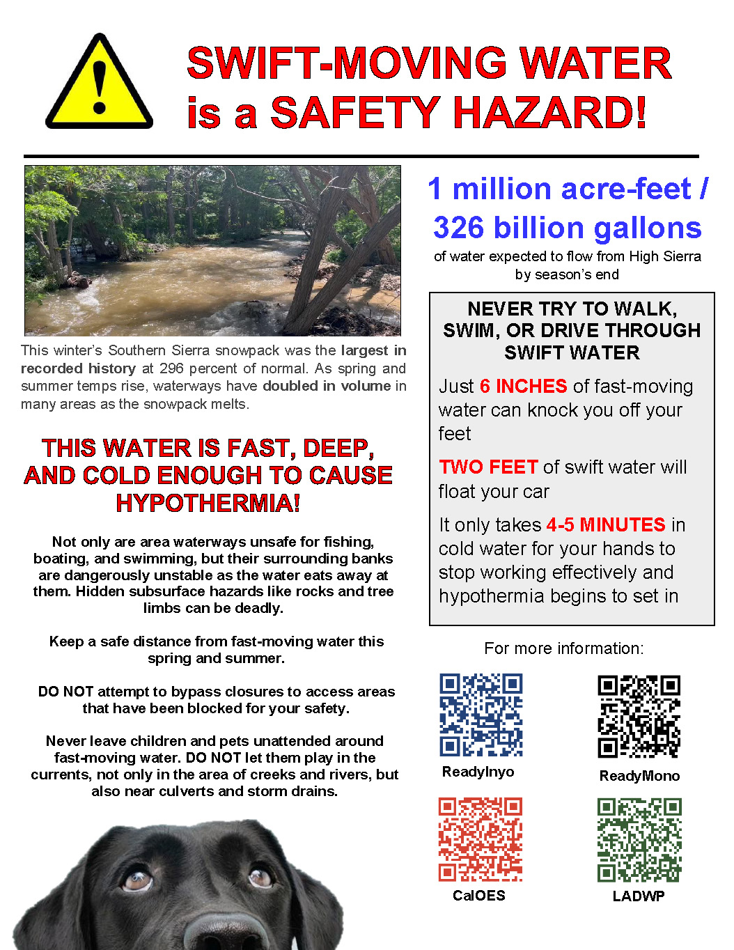
**PUBLIC SAFETY ALERT—STAY OUT OF COLD SWIFT FLOWING WATER**
This incident happened over the Memorial Day weekend in Bishop Creek: https://goldrushcam.com/sierrasuntimes/index.php/news/local-news/46444-woman-dies-in-inyo-county-after-falling-into-bishop-creek-son-swept-away-attempting-rescue-is-able-to-reach-land-and-call-for-help\
REMEMBER: COLD SWIFT-MOVING WATER is a SAFETY HAZARD!
This winter’s Southern Sierra snowpack was the largest in recorded history at 296 percent of normal. As spring and summer temps rise, waterways have doubled in volume in many areas as the snowpack melts.
1 million acre-feet / 326 billion gallons of water expected to flow from High Sierra by season’s end.
THIS WATER IS FAST, DEEP, AND COLD ENOUGH TO CAUSE HYPOTHERMIA!
- Not only are area waterways unsafe for fishing, boating, and swimming, but their surrounding banks are dangerously unstable as the water eats away at them. Hidden subsurface hazards like rocks and tree limbs can be deadly.
- Keep a safe distance from fast-moving water this spring and summer.
- DO NOT attempt to bypass closures to access areas that have been blocked for your safety.
- Never leave children and pets unattended around fast-moving water. DO NOT let them play in the currents, not only in the area of creeks and rivers, but also near culverts and storm drains.
NEVER TRY TO WALK, SWIM, OR DRIVE THROUGH SWIFT WATER!
- Just 6 INCHES of fast-moving water can knock you off your feet
- TWO FEET of swift water will float your car
- It only takes 4-5 MINUTES in cold water for your hands to stop working effectively and hypothermia begins to set in
**NOTE PSA SWIFT WATER SAFETY FLYER ATTACHED BELOW UNDER RELATED INFORMATION**
Grindstone Ranger District pile burning at Letts Lake and Mill Valley May 31 2023
Related Incident: Mendocino NF 2023 RX Fire Projects
Publication Type: News
The Grindstone Ranger District is planning pile burning at Letts Lake and Mill Valley today. 10 acres is planned in Mill Valley near the campground. 15 acres is planned at the south end of Letts Lake near the road.
Ignitions are dependent on favorable weather conditions. Updates on the project will be provided after completion.
*Update - On Wednesday, May 31, 2023, firefighters successfully completed 15 acres of hand piles in the Letts Lake Campground and 10 acres of hand piles in Mill Valley. As of Friday, June 2, the two projects remain in patrol status with minimal heat and smoke remaining. Most piles have burned down and are cold. Piles will remain in patrol status through the weekend.
20230531PassFireUpdate
Related Incident:
Publication Type: News
Pass Fire Update - May 31, 2023
Acres: 10,508 acres
Location: 40 miles west of Winston, NM
Containment: 0%
Personnel: 150
Start Date: May 15, 2023
Cause: Lightning-caused
Fuels: Timber and grass
Structures Lost: None
Reconnaissance flights today will provide perspective of entire Pass Fire
Helicopter aerial reconnaissance flights are planned for early today. This provides an opportunity for assessing the condition of the Pass Fire footprint from an “eyes in the sky” perspective. These flights are strategically planned and scheduled for key personnel who have direct involvement and/or leadership in fire operations. This aerial view allows fire managers to see the entire perimeter, current fire behavior, fuel consumption, and burn patterns. If flight conditions are not favorable, the aerial mission will be rescheduled.
Incident Commander, Pete Valenzuela added, “the reconnaissance flights provide an opportunity to see the unburned areas that are in path of the fire, including fuel types. This assessment is used to identify potential areas where the fire’s spread will be allowed to continue or where to strategically and safely take actions in preparation for holding the fire well in advance of its arrival.”
Weather: High temperatures will be near normal, high 80’s with winds increasing this afternoon. A Red Flag Warning in effect for Southwest New Mexico until 9:00 PM today. Conditions are expected to improve after sunset when temperatures decrease and winds become light and terrain-driven. Warm, dry weather is expected to continue through the end of the week. As Red Flag conditions materialize, fire behavior and fire spread are expected to increase.
Closures: There are no road closures at this time, however firing operations are ongoing over the next few days along Highway 59 as the fire continues to spread under current and favorable fuel and weather conditions. Travelers are asked to be mindful of possible smoke impacts on or near the highway. Please slow down and watch for fire crews and engines working in the vicinity and along the edge of the highway. Firing operations along Highway 59 are expected to continue possibly into the weekend.
Aviation Restrictions: Currently, there is no Temporary Flight Restriction (TFR) in place over the Pass Fire, however, be advised that this could change, should aerial support be needed. A “TFR” restricts non-fire aircraft. This includes civilian drones. Unauthorized aircraft in the area can ground firefighting aircraft and hinder firefighting efforts.
Situational Awareness for the Public
INCIWEB is the official site for fire information, visit: https://inciweb.nwcg.gov
The “.gov” means it’s official. Before sharing sensitive information, make sure you’re on a federal government site. The site is secure and updated daily.
Go directly to the PASS FIRE: https://inciweb.nwcg.gov/incident-information/nmgnf-pass-fire
Fire Information and Media Line: 720-693-3527/ Hours: 8 am – 8 pm
Settings - change map background and toggle additional layers
Filter - control incident types displayed on map.
Zoom to your location
Reset map zoom and position
Could not determine your location.
Show Legend
 Wildfire
 Prescribed Fire
 Burned Area
Response
Burned Area
Response Other
Other
2023 Klamath NF Spring Lightning Fires
Unit Information
Incident Contacts
May 30 Lava Fields Prescribed Fire Update Archive
Related Incident:
Publication Type: News
Tuesday, May 30 Update, 11:00 a.m.
This morning's test fire was successful and crews have started ignitions on the Lava Fields Prescribed Fire in El Malpais National Monument. Ignitions will continue through the day.
Smoke and flames may be visible in the Highway 53 corridor. Motorists are urged to slow down, turn on their headlights, and be aware of firefighters that may be working along the roadway. If conditions warrant, a pilot car may be used along Hwy 53. The El Calderon Road (NPS 100 Road), and all caves and trails (including the Continental Divide Trail, which will be temporarily re-routed) in the area will be closed to non-resident traffic during ignitions.
Prescribed fire operations began today, May 30, and fire managers expect that the operation will take four to five days to complete. Ignitions are expected to begin late morning into midday and continue into the afternoon each day. If conditions are not right, operations may be delayed until the weather or fuels are right to achieve the desired effects on the land. Firefighters will monitor the area after ignitions are complete.
Smoke will be most visible on days when burning occurs, mostly during the warmest part of the day. With cooler temperatures in the evening, smoke may linger in low-lying areas for a few days after burn operations are complete.
El Malpais is a fire dependent ecosystem. Land managers use prescribed fire to reduce hazardous fuel loads, manage landscapes, and achieve ecological benefits. The Lava Fields prescribed fire will treat approximately 1,000 acres of NPS lands.
For questions about the prescribed fire call the El Malpais National Monument Visitor Center at (505) 876-2783.