
20230614PassFireUpdate
Related Incident:
Publication Type: News
Today is the final update on the Pass Fire. Moving forward, updates will be released twice per week, unless fire behavior changes significantly. Please also note the Pass Fire information phone number has changed.
Acres: 50,123
Start Date: May 18, 2023
Location: 40 miles west of Winston, NM
Cause: Lightning
Containment: 13%
Fuels: Timber, pinon/juniper and grass
Personnel: 54
Southwest winds for the past couple of days have aided the Pass fire to steadily consume ground fuels and surface vegetation. An infrared flight last night showed 288 acres of new growth within isolated pockets of heat. Fire activity was observed in Trap Corral Canyon just west of Trap Corral Tank. Most of the fire activity is still located between House Log Canyon and Windfall Canyon.
Firefighters will continue collecting fuel samples to stay informed of current fuel moistures that will assist with forecasting future fire behavior. Their daily missions are to patrol and monitor the Pass Fire from the air and ground, taking appropriate measures to ensure it stays confined within the identified boundaries and protect values at risk.
Visitors are reminded to use extreme caution and exercise common sense when traveling near the fire area.
The low-to moderate intensity of the Pass fire is thinning out crowded young stands of trees, reducing the amount of fuel on the forest floor, add nutrients to the soil to rejuvenate plant life which will produce new forage for wildlife.
Weather: Sunny, with highs around 80. West winds from 5 to 10 mph, increasing to southwest 20 to 25 mph this afternoon.
Aviation Restrictions: A Temporary Flight Restriction (TFR) is still in place over the Pass Fire. All non-fire aircraft are restricted. This includes civilian drones. Unauthorized aircraft in the area will ground firefighting aircraft, hindering firefighting efforts. If you fly, we can’t.
For More Information:
- Inciweb: https://inciweb.wildfire.gov/incident-information/nmgnf-pass-fire Inciweb is the official site for fire information. This site is secure and updated daily.
- New Mexico Fire Information: https://nmfireinfo.com/
- Air Quality: https://www.airnow.gov
NEWS RELEASE Prescribed burning to start June 6 on Inyo National Forest
Related Incident: INYO NATIONAL FOREST 2023 PRESCRIBED FIRE PROJECTS
Publication Type: News
Inyo National Forest - News & Events (usda.gov)
Prescribed burning to start June 6 on Inyo National Forest
Release Date: Jun 1, 2023
Public Affairs Officer: Lisa Cox
(760) 873-2427
lisa.cox@usda.gov
BISHOP, Calif., June 1, 2023 — Starting Tuesday June 6, Inyo National Forest firefighters with assisting agencies will be burning several hundred acres of accumulated needle cast and ground-level vegetation in the coming weeks at three different locations on the forest. Smoke will be visible and air quality may be impacted depending on weather conditions.
The first two locations will be broadcast burns, the type of burn that is ignited across the landscape within defined boundaries. “These prescribed fire areas are burned on a recurring rotation to best mimic the natural fire return interval and restore natural fire intensities,” said Jennifer Martin, Fire Management Specialist (Fuels Planner) for Inyo National Forest, and also is the Burn Boss for this project. “Reducing fuel loading will decrease future wildland fire intensity and severity, lowering the risk of negative impacts to ecosystems, cultural resources, and communities that can result from uncharacteristically severe wildfires.”
The projects are as follows:
“Casa Diablo” located east of Crowley Lake:
- Starting June 6 and continuing for approximately two weeks or more
- 100 to 500 acres per day will be burned as conditions allow
- Under the most optimal conditions, target acreage is approximately 3,000 acres for this year.
“Antelope” located east of Smokey Bear Flat and south of Owens River Road:
- Starting mid to late June
- 600 acres, over several days
- Later in June and July, firefighters will also be pile burning in both the Lakes Basin and Reds Meadow areas. Another news release will be sent out at a later time with more details.
As different phases of the prescribed burns are met, information will be released via:
· Inciweb: inciweb.wildfire.gov
· Facebook: www.facebook.com/inyonf
· Forest website: www.fs.usda.gov/alerts/inyo/alerts-notices
Smoke is expected to be visible from Highways 395, 6, 120, as well as from the communities of Crowley Lake, Sunny Slopes, Tom’s Place, Swall Meadows, potentially the Town of Mammoth Lakes and beyond, depending on winds and how the smoke settles at night time. All prescribed fire activities will be coordinated with the Great Basin Unified Air Pollution Control District in order to provide the best smoke dispersion and to reduce impacts to Eastern Sierra communities.
To check air quality, visit airnow.gov.
![]() Red pin drops are approximate locations for the Antelope and Casa Diablo burn units
Red pin drops are approximate locations for the Antelope and Casa Diablo burn units
###
June 13 2023 Update
Related Incident: Dorado/Cañada del Agua Prescribed Fire
Publication Type: News
After careful discussion with meteorologists and fuels specialists, Carson National Forest fire crews are continuing to work toward ignitions of the Dorado/Cañada del Agua Prescribed Fire tomorrow morning (map). The public can expect to see smoke south of Tres Piedras, NM, and west of U.S. Route 285. Please do not call 911.
“As the final decision maker for this project, I am considering new information as it comes in,” said District Ranger Angie Krall, who is also the agency administrator for the prescribed fire. “I have no problem postponing ignitions, even minutes before, if adverse information comes to light.”
The latest National Weather Service Spot weather forecast for Wednesday at the prescribed fire location calls for surface winds out of the west, starting at 5 to 8 mph in the morning and increasing to 10 to 16 mph in the afternoon, with excellent smoke dispersal. The minimum humidity is forecasted to be 15 to 19 percent. Krall and fire personnel will review an updated Spot forecast, which will be available online, in the morning before considering final approval for ignitions.
To maintain resiliency, fire-adapted forests in the Southwest must undergo fire disturbance on a regular basis. Prescribed fire removes duff, dead leaves and pine needles that contribute to fuel loading. It also recycles nutrients back to the soil, promotes the growth of trees and improves habitat for wildlife.
After a prescribed fire is completed, if a future wildfire reaches the area, the fire behavior will likely be modified to a less intense, more manageable surface fire making it safer for firefighters to engage.
The public can keep updated with prescribed fire operations at InciWeb, the forest’s social media accounts (Facebook, Twitter) and by phone at 505-418-1038.
Settings - change map background and toggle additional layers
Filter - control incident types displayed on map.
Zoom to your location
Reset map zoom and position
Could not determine your location.
Show Legend
 Wildfire
 Prescribed Fire
 Burned Area
Response
Burned Area
Response Other
Other
INYO NATIONAL FOREST 2023 PRESCRIBED FIRE PROJECTS
Unit Information
Incident Contacts
LS Mesa Fire contained
Related Incident:
Publication Type: News
LS Mesa Fire fully contained
Strong aerial support and quick action by ground crews were the recipe for success
SILVER CITY, NM, June 13, 2023 – The LS Mesa Fire, which ignited Friday, June 9, due to an unknown cause, is 100% contained at 132 acres.
“A strong aerial attack on Saturday set up ground crews for success on Sunday and Monday,” said New Mexico Forestry Division’s Incident Commander, Jose Ramos. “The retardant lines surrounding the forward fire flank gave crews time and opportunity to surround the fire perimeter with containment line and then mop up any remaining hot spots within the fire’s interior.”
No additional smokes were visible within the fire perimeter yesterday evening. This will be the final notification unless there are significant changes.
More information about the LS Mesa Fire is available at Wildfire | InciWeb For New Mexico Forestry Division, contact George Ducker, Communications Coordinator at 505-699-0601, or george.ducker@emnrd.nm.gov. For Gila National Forest, contact Maribeth Pecotte, Public Affairs Officer at 575-388-8211 or Maribeth.Pecotte@usda.gov.
LS Mesa Fire update for June 12 Containment at 60
Related Incident:
Publication Type: News
SILVER CITY, NM, June 12, 2023 – Crews established containment lines around all sides of the LS Mesa Fire yesterday, declaring the fire 60% contained today. It is located approximately 9 miles east of Gila, New Mexico on public lands managed by the New Mexico Forestry Division, the Bureau of Land Management, and Gila National Forest. Driven by gusty winds, the LS Mesa Fire remains at 132 acres in size and its cause is under investigation.
Today, ground crews have continued identifying and extinguishing sources of heat that could threaten to escape the fire’s perimeter. Responding crews include one New Mexico Forestry Division engine and three Forest Service fire engines, two Forest Service 10-person fire suppression modules, a New Mexico Forestry Division 5-person initial attack module, and the 20-person Silver City Hotshot crew. Available air resources include two Type 3 helicopters and a Type 1 helicopter, two single engine air tankers, two large air tankers, and a very large air tanker, along with a fixed-wing air attack platform to oversee aerial resources.
The weather forecast over the fire area this week projects high temperatures in the 80s to 90s, with gusty winds and no precipitation in the forecast.
More information about the LS Mesa Fire is available at Wildfire | InciWeb For New Mexico Forestry Division, contact George Ducker, Communications Coordinator at 505-699-0601, or george.ducker@emnrd.nm.gov. For Gila National Forest, contact Maribeth Pecotte, Public Affairs Officer at 575-388-8211 or Maribeth.Pecotte@usda.gov.
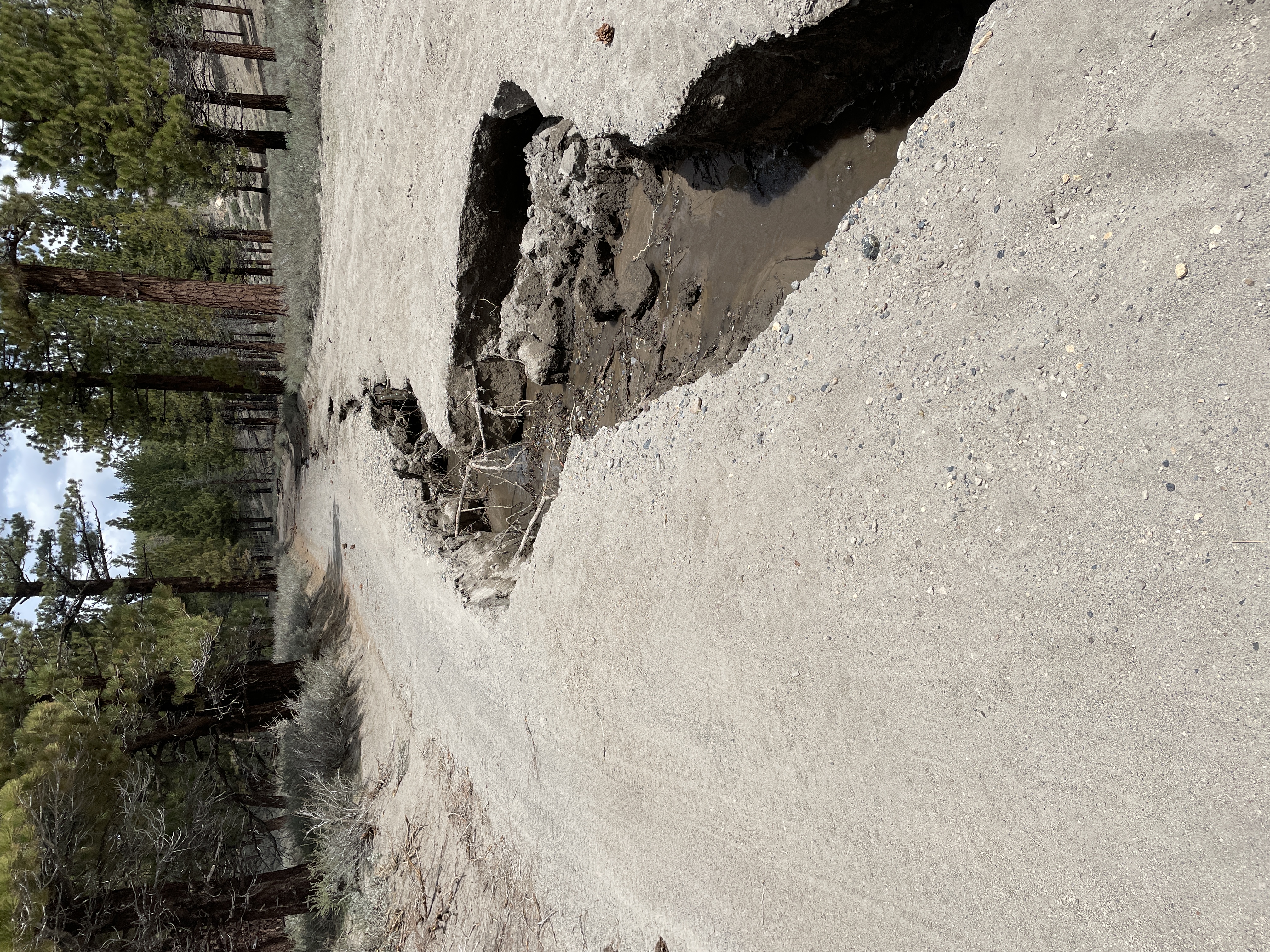
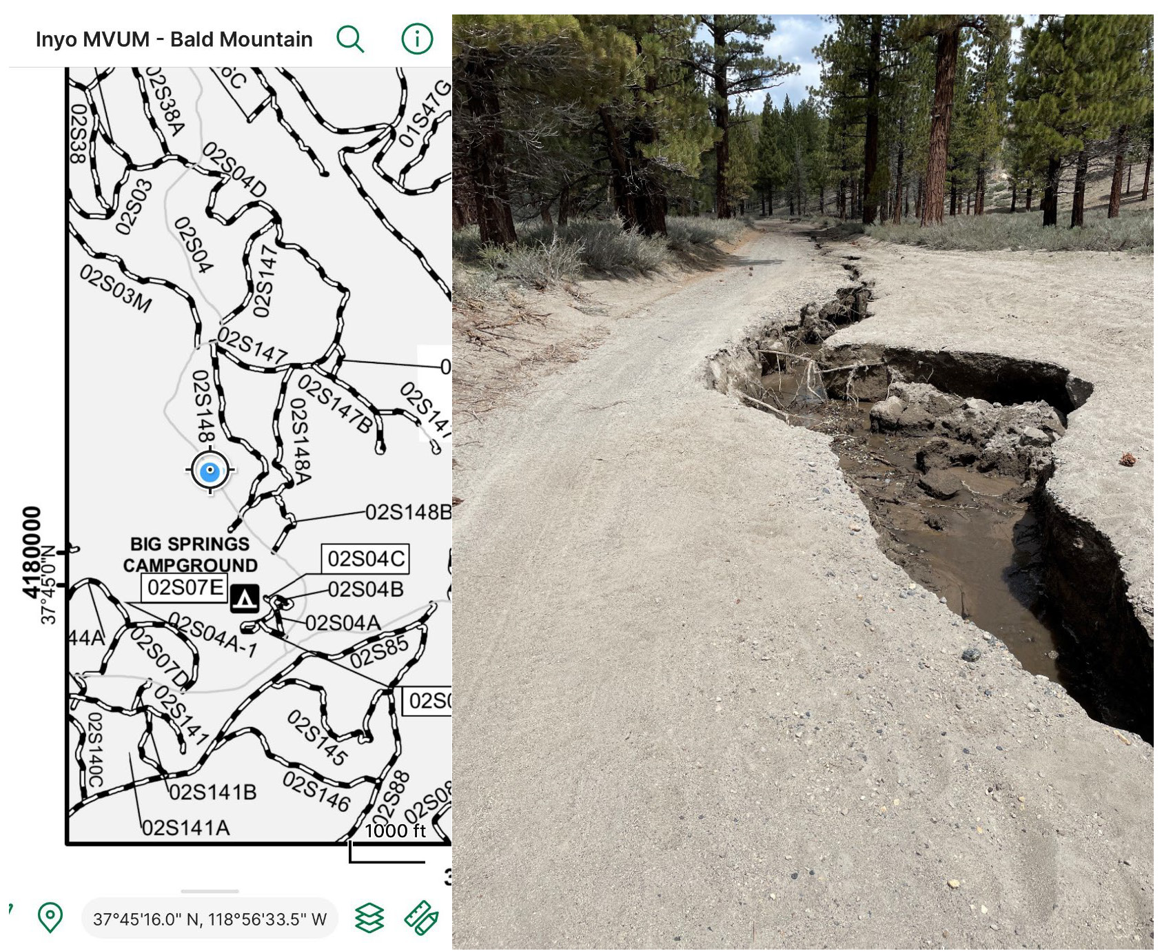
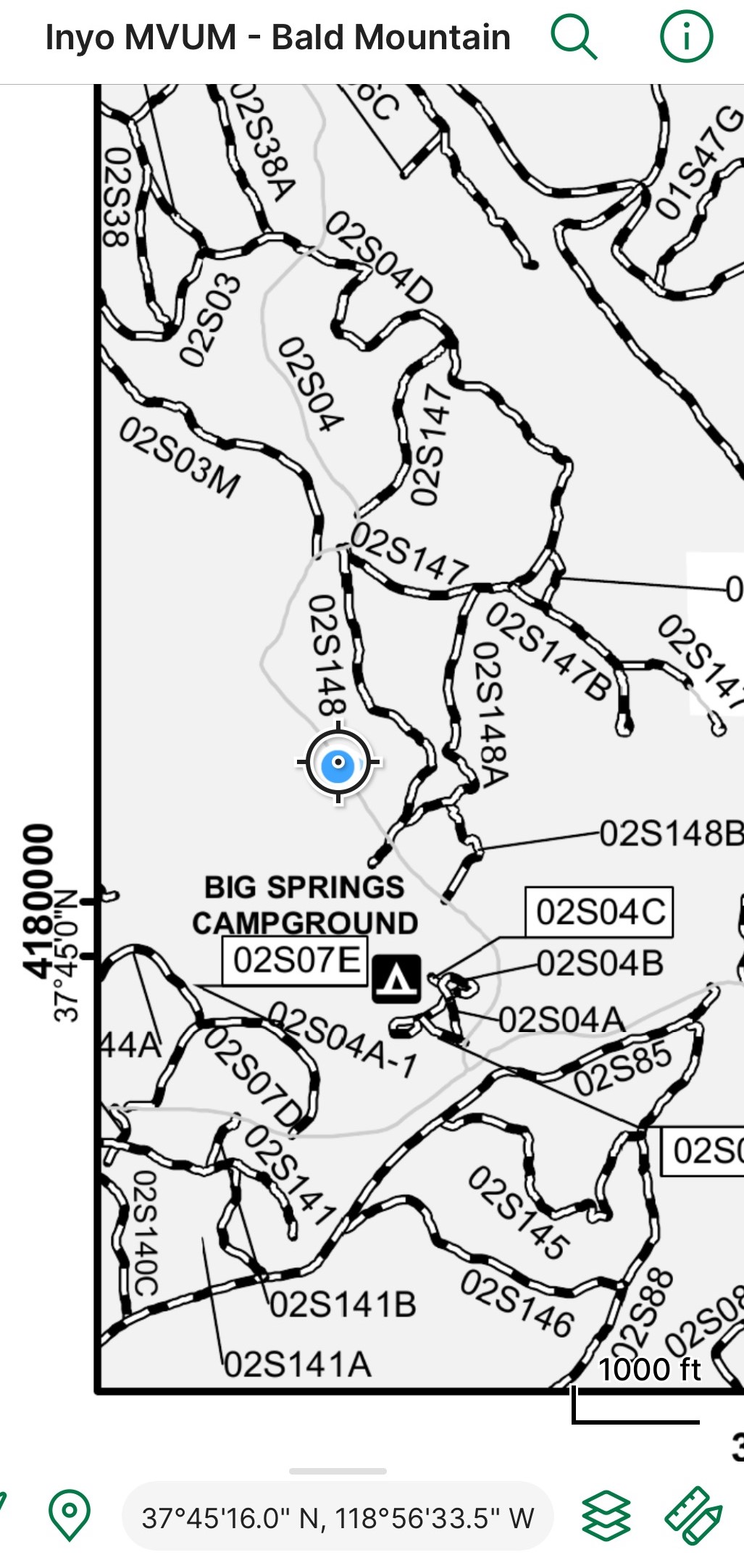
Big Washout on FS2S04 Road Behind Big Springs
Related Incident: INYO NATIONAL FOREST--FLOOD RESPONSE
Publication Type: Announcement
Photo of Big Washout of FS 2S04 Road Behind Big Springs.
Snow melt flooding caused portion of FS 2S04 Road to wash away.
See Photo-Map at the top Photos Tab called FS 2S04 ROAD
Also see photo and photo-map in various formats below under related information.
20230613PassFireUpdate
Related Incident:
Publication Type: News
Pass Fire Update for June 13, 2023
Acres: 49,835
Location: 40 miles west of Winston, NM
Containment: 13%
Personnel: 54
Start Date: May 18, 2023
Cause: Lightning
Fuels: Timber, pinon/juniper and grass
The Pass fire has moved slowly through 81 additional acres according to the latest fly over with infrared optics. It is still burning at a low to moderate intensity, producing minimal smoke with isolated torching in the interior. Most of the active fire is located between House Log Canyon and Windfall Canyon. Fire has burned down to the flowing edge of Indian Creek on the western flank of the fire. Firefighters are working in the area, monitoring fire activity and collecting fuel samples to keep informed of current fuel moistures and assist with forecasting future fire behavior.Managing the Pass fire under a confine-contain approach can help firefighters fight any future fires that may be in this area, because the removal of accumulated surface fuels through low to moderate intensity burning, reduces the likelihood of future severe fire behavior.
Firefighters are monitoring and patrolling from the air and ground ensuring the Pass fire stays within the pre-determined planning area. As temperatures warm and conditions become drier, fire activity and smoke will increase. Visitors are reminded to use extreme caution when traveling near the fire area.
Weather: Sunny, with a high near 74. West southwest wind 25-35 mph by afternoon. Elevated fire danger between now and Wednesday.
Aviation Restrictions: A Temporary Flight Restriction (TFR) is still in place over the Pass Fire. All non-fire aircraft are restricted. This includes civilian drones. Unauthorized aircraft in the area will ground firefighting aircraft, hindering firefighting efforts.
Closures: The Gila National Forest remains open. Visitors are encouraged to use extreme caution when traveling near the fire area, due to the presence of firefighters and equipment.
For More Information:
- Inciweb: https://inciweb.wildfire.gov/incident-information/nmgnf-pass-fire Inciweb is the official site for fire information. This site is secure and updated daily.
- New Mexico Fire Information: https://nmfireinfo.com/
- Air Quality: https://www.airnow.gov
Crews Planning Prescribed Fire Ignitions South of Tres Piedras
Related Incident: Dorado/Cañada del Agua Prescribed Fire
Publication Type: News
Carson National Forest fire crews are planning to move forward with the Dorado/Cañada del Agua Prescribed Fire to the south of Tres Piedras, NM, this week. Ignitions could begin as early as Wed., Jun. 14, however the actual first day of operations will be determined by weather and on-site conditions.
“We’ve been trying to find an opportunity to implement this important project all spring,” said District Ranger Angie Krall, “and the weather and conditions are lining up really nicely.”
The purpose of the 3,318-acre Dorado/Cañada del Agua Prescribed Fire, which is within the Rio Chama Collaborative Forest Landscape Restoration Project boundaries, is to return the ponderosa forest setting to a condition that more closely resembles its natural state, where frequent and low intensity surface fires burn ground fuels and small trees while maintaining an open stand of larger trees. Ponderosa pine forests historically burned every five to 25 years, but after a century of aggressive fire suppression, high-grade logging and other actions, their structure has changed and are prone to burning with higher temperatures and intensities.
The Dorado/Cañada del Agua Prescribed Fire footprint is partially surrounded by previously burned areas that serve as barriers to prevent rapid fire spread outside the project site. Two prescribed fires from 2016 and 2019 border parts of the eastern and northern flanks and the 2017 Hondito Fire lines parts of the western and northern flanks.
Struck by lightning, the Carson National Forest managed the Hondito Fire to over 7,000 acres with goals of reducing forest fuels, enhancing wildlife habitat, improving forest and watershed health and protecting nearby communities. While fire personnel planned for the fire to reach up to 15,000 acres, the weather stopped its spread.
The Hondito Fire is similar to ongoing management of the 16-acre Comanche Fire, which is located approximately 20 miles to the southwest of the Dorado/Cañada del Agua Prescribed Fire footprint. Fire crews are currently actively managing the Comanche Fire to reduce high-severity wildfires.
Updates for the Dorado/Cañada del Agua Prescribed Fire will be posted on InciWeb and the forest’s social media channels (Facebook, Twitter).
20230612PassFireUpdate
Related Incident:
Publication Type: News
Pass Fire Update for June 12, 2023
Acres: 49,754
Location: 40 miles west of Winston, NM
Containment: 13%
Personnel: 54
Start Date: May 18, 2023
Cause: Lightning
Fuels: Timber, pinon/juniper and grass
Yesterday’s southwest winds pushed the Pass Fire back into itself with new growth of only 639 acres in the fire’s interior. Most of the fire activity was showing between House Log Canyon and along the south end of Jordan Canyon, near Jordan Hot Springs, where low to moderate fire intensity is steadily cleaning up ground fuels including downed logs, brush, pine needles, along with some pine stringers. Since there are no closures, visitors are reminded to use extreme caution when traveling near the fire area.
At the start of the Pass Fire in May, moist vegetation and cooler temperatures allowed the fire to play its natural role in a fire-adapted ecosystem. This was due to recent intermittent rains and the moisture received over the last months.
As expected, the Pass Fire has continued to burn with low to moderate intensity gradually consuming excess ground fuels, some pine stringers, and improving the landscape. Firefighters are working to keep the fire within the established boundaries under a confine-contain strategy, using various methods, including roads, natural barriers in wilderness and constructing containment lines. Aerial ignitions have allowed for slow consumption of fuels to protect values at risk.
Firefighters are monitoring and patrolling from the air and ground ensuring the Pass fire stays within the pre-determined planning area.
Weather: Sunny, with a high near 77. West southwest wind 5 to 10 mph increasing to 18 to 23 mph in the afternoon. Winds could gust as high as 31 mph.
Aviation Restrictions: A Temporary Flight Restriction (TFR) is still in place over the Pass Fire. All non-fire aircraft are restricted. This includes civilian drones. Unauthorized aircraft in the area will ground firefighting aircraft, hindering firefighting efforts.
Closures: The Gila National Forest remains open. Visitors are encouraged to use extreme caution when traveling near the fire area, due to the presence of firefighters and equipment.
For More Information:
- Inciweb: https://inciweb.wildfire.gov/incident-information/nmgnf-pass-fire Inciweb is the official site for fire information. This site is secure and updated daily.
- New Mexico Fire Information: https://nmfireinfo.com/
- Air Quality: https://www.airnow.gov