
June 11 2023 Update
Related Incident: Comanche Fire
Publication Type: News
With no threat to lives, homes or infrastructure from the Comanche Fire, which was caused by lightning, Carson National Forest crews are currently moving forward with a confine and contain strategy. This response allows fire to play its natural role in a fire-dependent ecosystem, which is a desired condition outlined in the Carson National Forest’s 2022 Land Management Plan.
“In frequent fire systems, like where the Comanche Fire is located, regular fire helps mitigate future high-severity disturbances from severe wildfires and insect outbreaks,” said District Ranger Angie Krall. “Our long-term vision for the forest is a future in which ignitions are primarily natural or planned instead of unplanned human-caused fires.”
The Comanche Fire was first detected Thursday and is 14 acres, having grown three acres since Saturday evening. Activity is light, with fire creeping along the forest floor and consuming ground fuels. It is located on the El Rito Ranger District near the communities of El Rito, Abiquiu and Canjilon.
Fire crews are currently on scene monitoring the fire and checking burned areas for beneficial ecological effects. Additionally, forest staff are beginning to order more resources and equipment and planning potential containment lines along the existing road network.
The confine and containment strategy means using tactical actions to manage the fire within a predetermined area (confine) and then using points to stop the fire’s spread (contain).
Smoke is currently minimal but visible from parts of Abiquiu, NM. An incident meteorologist and smoke monitors have been ordered. Staff are coordinating with the New Mexico Environment Department and will follow smoke management guidelines. Go to Smoke Management | New Mexico Fire Information for more about smoke and actions to take to protect your health.
Keep updated about the Comanche Fire online at InciWeb and the Forest’s social media (Twitter, Facebook). Public information officers will soon deploy information in physical locations in nearby communities.
LS Mesa Fire update for June 11
Related Incident:
Publication Type: News
SILVER CITY, NM, June 11, 2023 – The LS Mesa Fire is located approximately 9 miles east of Gila, New Mexico on New Mexico state lands and the Gila National Forest. Driven by gusty winds, the LS Mesa Fire grew to an updated 132 acres yesterday, following fuels and terrain to the northeast.
Retardant lines laid down by fixed-wing aircraft yesterday have stalled further growth of the fire, aiding with containment along the east flank. All ground crews are engaged in containment line construction, making good progress on all sides of the fire perimeter. Working in the interior, they are identifying and extinguishing sources of heat that could threaten to escape the fire’s perimeter.
The fire was reported Friday night by the Signal Peak Lookout. A combination of state and Forest Service firefighting resources are aggressively suppressing the fire, whose cause is under investigation. Responding crews include one New Mexico Forestry Division and three Forest Service fire engines, two Forest Service 10-person fire suppression modules, a New Mexico Forestry Division 5-person initial attack module, and the Silver City Hotshots. Available air resources include two Type 3 helicopters and a Type 1 helicopter, two single engine air tankers, two large air tankers, and a very large air tanker, along with a fixed-wing air attack platform to oversee aerial resources. One additional hand crew has been ordered.
There are nonresidential private lands located to the north, west, and east of the fire’s current location, and no structures are threatened. Crews are observing minimal smoke along the eastern flank of the fire in a drainage today, where fuels are denser. Winds are gusty over the fire area.
Weather is on a warming, drying trend and strong, gusty winds will make fuels more receptive to fire over the forecast period. Remembering that up to 85% of all wildfires are human caused, please help avoid wildfire ignitions elsewhere by dousing campfires with plenty of water, stirring to wet all coals, and feeling for heat with the back of your hand. When the coals feel cool to the touch with your bare hand, your fire is out. More information about the LS Mesa Fire is available at Wildfire | InciWeb or contact Maribeth Pecotte at 575-388-8211 or Maribeth.Pecotte@usda.gov.
20230611PassFireUpdate
Related Incident:
Publication Type: News
Pass Fire Update for June 11, 2023
Acres: 49,115
Location: 40 miles west of Winston, NM
Containment: 13%
Personnel: 54
Start Date: May 18, 2023
Cause: Lightning
Fuels: Timber, pinon/juniper and grass
An infrared flight mapped the fire at 49,115 yesterday and found scattered heat throughout the interior of the fire. Smaller areas of intense heat were showing along Indian Creek where the fire is gradually working its way along the canyon burning in pine stringers and ground fuels. Some isolated single torching of pines was visible in the interior of the fire. The Pass fire is still burning within the established boundaries.
Today, southwest winds will increase to 20-30 mph, pushing the fire back into itself. As conditions become hotter, grasses and vegetation will become drier, making them more receptive to fire.
Firefighters are monitoring and patrolling from the air and ground ensuring the Pass fire stays within the planned area.
Weather: Today will be sunny, hotter, and drier with temperatures becoming as high as 80 degrees and winds will be out of the south and southwest at 20-30 mph. Smoke will increase and may settle in the valleys by early morning, however, should lift my mid-morning.
Aviation Restrictions: A Temporary Flight Restriction (TFR) is still in place over the Pass Fire. All non-fire aircraft are restricted. This includes civilian drones. Unauthorized aircraft in the area will ground firefighting aircraft, hindering firefighting efforts.
Closures: The Gila National Forest remains open. Visitors are encouraged to use extreme caution when traveling near the fire area, due to the presence of firefighters and equipment.
For More Information:
- Inciweb: https://inciweb.wildfire.gov/incident-information/nmgnf-pass-fire Inciweb is the official site for fire information. This site is secure and updated daily.
- New Mexico Fire Information: https://nmfireinfo.com/
- Air Quality: https://www.airnow.gov
Crews responding to LS Mesa Fire near Gila New Mexico
Related Incident:
Publication Type: News
Fire crews responding to LS Mesa Fire near Gila, New Mexico
Fire burning in grass, brush, pinon and juniper, driven by gusty winds
RESERVE, NM, June 10, 2023 – A new fire ignition was spotted Friday evening by the Signal Peak lookout, approximately 9 miles east of Gila, New Mexico on the Gila National Forest. Driven by gusty winds, the LS Mesa Fire has grown to about 125 acres, following fuels and terrain to the northeast.
Incident Commander Ed Huerta said, “Recent hot, dry and windy conditions have made fuels more receptive to fire, which is consuming heavy grasses in a pinon/juniper woodland.”
The fire started on New Mexico state land in the Dorsey Mesa area and moved onto Gila National Forest. A combination of state and Forest Service firefighting resources are aggressively suppressing the fire, whose cause is under investigation. There are currently four fire engines, two 10-person suppression modules, a 5-person initial attack module responding, along with two Type 3 helicopters that are being used primarily as crew transport, and a Type 1 helicopter dropping buckets of water to cool flare ups and slow the fire’s advance. Two single engine air tankers, two large air tankers, and a very large air tanker are laying down retardant. A fixed-wing air attack platform is overseeing aerial resources. Two additional hand crews have been ordered.
There are private lands located to the north, west, and east of the fire’s current location. Light smoke is visible from Silver City.
More information about the LS Mesa Fire is available at Wildfire | InciWeb. For more information contact Maribeth Pecotte at 575-388-8211 or Maribeth.Pecotte@usda.gov.
###
USDA Forest Service is an equal opportunity provider, employer, and lender.
20230610PassFireUpdate
Related Incident:
Publication Type: News
Pass Fire Daily Update - June 10, 2023
Note: Map from 6-9-23 attached due to minimal changes on fire perimeter.
Acres: 48,750
Location: 40 miles west of Winston, NM
Containment: 13%
Personnel: 54
Start Date: May 18, 2023
Cause: Lightning
Fuels: Timber, pinon/juniper and grass
Widespread cloud cover resulted in lower fire activity yesterday. Most of the fire activity was burning into pine stringers in Indian Creek, where the fire will most likely run into rock bluff and stop. Firefighters, using an unmanned drone, flew an operational recon mission yesterday afternoon over the southwest area of the fire.
In the southwest portion, between Brothers West and House Log Canyon, fire moved towards the Middle Fork, and continues to back through grass and available fuels towards middle fork, as expected. The Middle Fork is one of the natural barriers used to keep the fire within the perimeter.
Winds out of the southwest and temperatures are expected to increase in the next couple of days. Resources will be assigned and released according to the needs to successfully hold the fire perimeter at its established boundaries.
The Pass fire has transitioned to a smaller local Type 3 organization as of 7 a.m. today.
Weather: Winds and heat will increase over the next few days, with no chance for precipitation anytime soon. Conditions will become drier and critical fire danger will return to the area. Southwest winds will push the fire back into itself. Interior smoke may be seen as pockets of fuel continue to be consumed.
Aviation Restrictions: A Temporary Flight Restriction (TFR) is still in place over the Pass Fire. All non-fire aircraft are restricted. This includes civilian drones. Unauthorized aircraft in the area will ground firefighting aircraft, hindering firefighting efforts.
Closures: The Gila National Forest remains open. Visitors are encouraged to use extreme caution when traveling near the fire area due to the presence of firefighters and equipment.
For More Information:
- Inciweb: https://inciweb.wildfire.gov/incident-information/nmgnf-pass-fire Inciweb is the official site for fire information. This site is secure and updated daily.
- New Mexico Fire Information: https://nmfireinfo.com/
- Air Quality: https://www.airnow.gov
Thomas Mountain Prescribed Burn San Jacinto Ranger District
Related Incident: 2023 - San Bernardino National Forest Wildfire Crisis Response
Publication Type: News
June 9, 2023 - San Bernardino National Forest, San Jacinto Ranger District has planned a prescribed firing operation for approximately 2500 acres on Thomas Mountain; west of the community of Garner Valley and southeast of the communities of Idyllwild and Mountain Center. This operation will occur from June 15 through June 22.
This project, as with many other fuels treatment projects undergo extensive analysis to best determine the proper treatment methods that will best benefit the landscape to meet the purpose and need of the treatment. In this case, multiple treatment types have been used to prepare the area for broadcast burning. This includes hand thinning and piling of vegetation followed by the burning of piles, mastication, tree/oak limbing and thinning, and the removal of fuels on the perimeter of the planned broadcast burn. Once the areas of thickest vegetation are either removed or thinned, broadcast burning is used to remove the understory of the timber canopy and/or areas of thick and decadent brush. This allows new and healthy vegetation to grow and prosper, enhancing the resiliency of the landscape.
There will be more than 100 firefighters from the U.S.D.A. Forest Service and partner agencies involved in active ignitions, which will last for five to seven days. These ignitions will be carried out through ground-based and helicopter aerial operations. After the active ignitions, there will be several additional days dedicated to mop-up, securement, and patrolling as needed.
During these operations certain areas will be temporarily closed to the public: Forest Road 6S13, Tool Box Springs Yellow Post Sites, Thomas Mountain Yellow Post Sites, and the Ramona Trail. These closures are implemented for the safety of both the public and firefighters involved in the operations.
Broadcast burning can be beneficial for protecting and enhancing habitat and foraging areas of multiple species of wildlife by removing invasive species and promoting the growth of native vegetation. It can also help to reduce the risk of severe wildfires by reducing the buildup of forest fuels and improving the health and resilience of the ecosystem by reintroducing fire to the landscape at a planned interval.
During broadcast burning, fire is spread across the landscape in a controlled manner, typically using specialized equipment such as drip torches or aerial ignition devices. These fires are closely monitored to ensure that they remain within the designated area and do not spread beyond control.
Prescribed fire plays an important role in forest health and in reducing extreme wildfires and their negative impact. These fires also help reduce heavy fuel loads while simultaneously opening the conifer forest structure and maintaining the health of meadow habitats. Fire is also used to enhance native plant communities and cultural landscapes and wildlife habitats. Another goal is to provide defensible space for communities and developed areas within and surrounding the San Bernardino National Forest.
With all fire comes smoke, and the U.S.D.A Forest Service works to mitigate smoke impacts from prescribed fires on the communities in the area. While smoke may be visible in the area during the prescribed fire operation, individuals with respiratory issues or sensitive conditions should take precautions to avoid exposure to smoke. The San Bernardino Nation Forest will provide updates and information about the prescribed fire operation to the public as needed. Please visit the InciWeb page for updates https://inciweb.nwcg.gov/incident-information/cabdf-2023- san-bernardino-national-forest-wildfire-crisis-response or visit our social media pages at Twitter at https://twitter.com/SanBernardinoNF and Facebook at https://www.facebook.com/SanBernardinoNF/.
20230609PassFireUpdate
Related Incident:
Publication Type: News
Information Phone: (575) 297-0790 Hours: 8 am-8pm
Email: 2023.Pass@Firenet.gov
Acres: 47,201
Location: 40 miles west of Winston, NM
Containment: 13%
Personnel: 88
Start Date: May 18, 2023
Cause: Lightning
Fuels: Timber, pinon/juniper and grass
***PLEASE NOTE NEW INFORMATION PHONE NUMBER***
Portions of the Pass Fire remain active, primarily on the southern edge of the fire in the Gila Wilderness area. Vegetation will continue to dry out as a hotter and drier weather pattern develops in the area. Crews flew several drone missions to check the area east of Indian Creek where the fire has been active near Brothers West. The area continues to hold. The southernmost portion of the fire is moving slowly southward toward the Middle Fork Gila River where a transition to a sparser fuel bed of Pinyon and Juniper is expected to hold the fire. The fire is also active in Burnt Corral Canyon and fire in that area, which had been previously ignited in a firing operation, has burned into the main body of fire near Jordan Canyon. It will now slowly burn to the north, back into previously burned area, and the south. The northern portion of the fire shows very little heat on infrared mapping data and is holding well. The increase in fire activity will help to consume more of the surface fuels but it is not expected to threaten the line.
The complexity of fighting the Pass Fire is decreasing and fire managers are preparing to transition to a local type 3 organization. This change will bring the resources assigned into alignment with current and projected needs to meet the objectives and continue to protect values at risk.
Weather: Warm and dry air will continue over the next few days. Relative humidity will be in the low teens in lower areas. This will continue to dry out the vegetation contributing to an increase in fire behavior.
Aviation Restrictions: A Temporary Flight Restriction (TFR) is still in place over the Pass Fire. All non-fire aircraft are restricted. This includes civilian drones. Unauthorized aircraft in the area will ground firefighting aircraft, hindering firefighting efforts.
Closures: The Gila National Forest remains open. Visitors are encouraged to use extreme caution when driving near the fire area due to the presence of firefighters and equipment.
For More Information:
- Inciweb: https://inciweb.wildfire.gov/incident-information/nmgnf-pass-fire Inciweb is the official site for fire information. This site is secure and updated daily.
- New Mexico Fire Information: https://nmfireinfo.com/
- Air Quality: https://www.airnow.gov
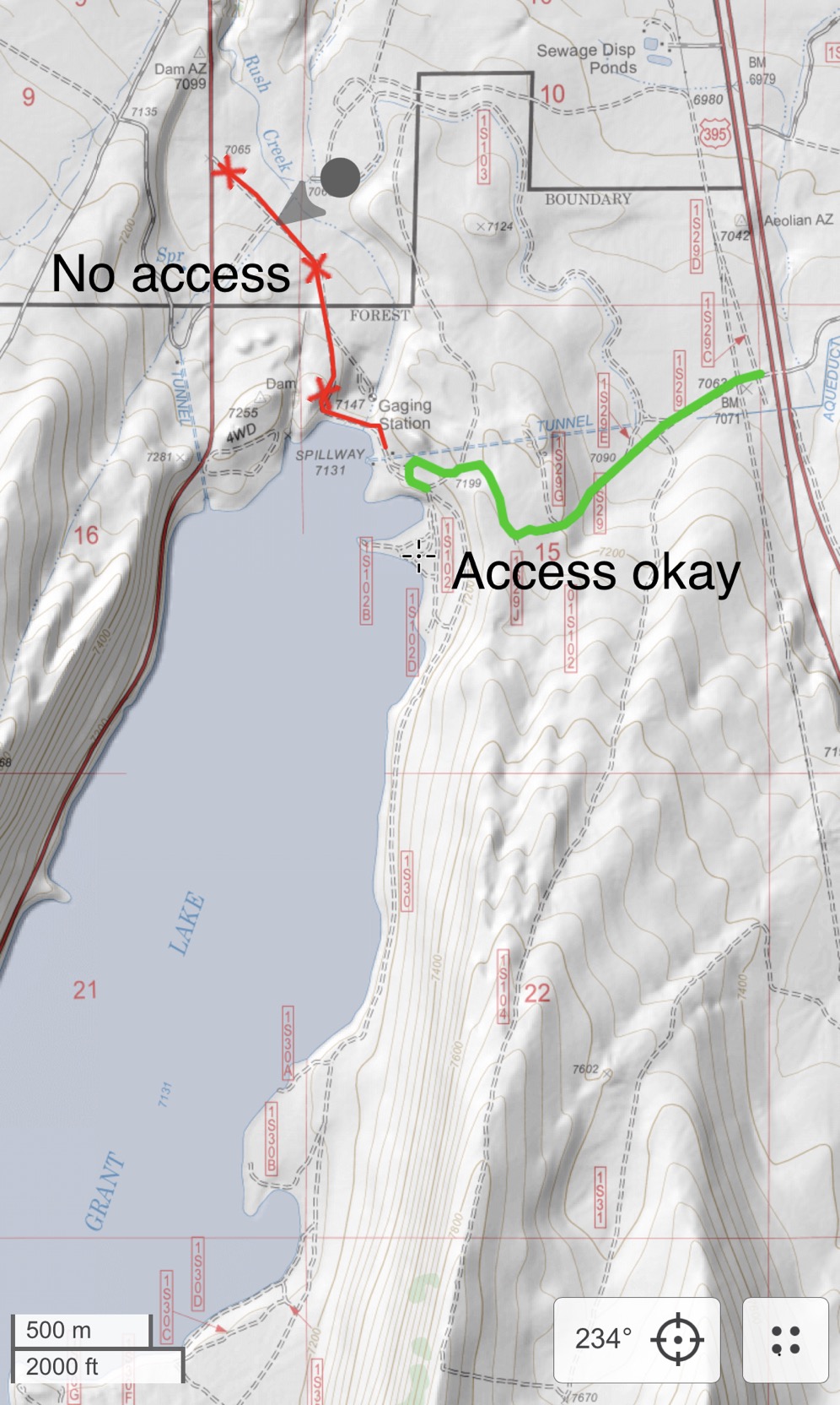
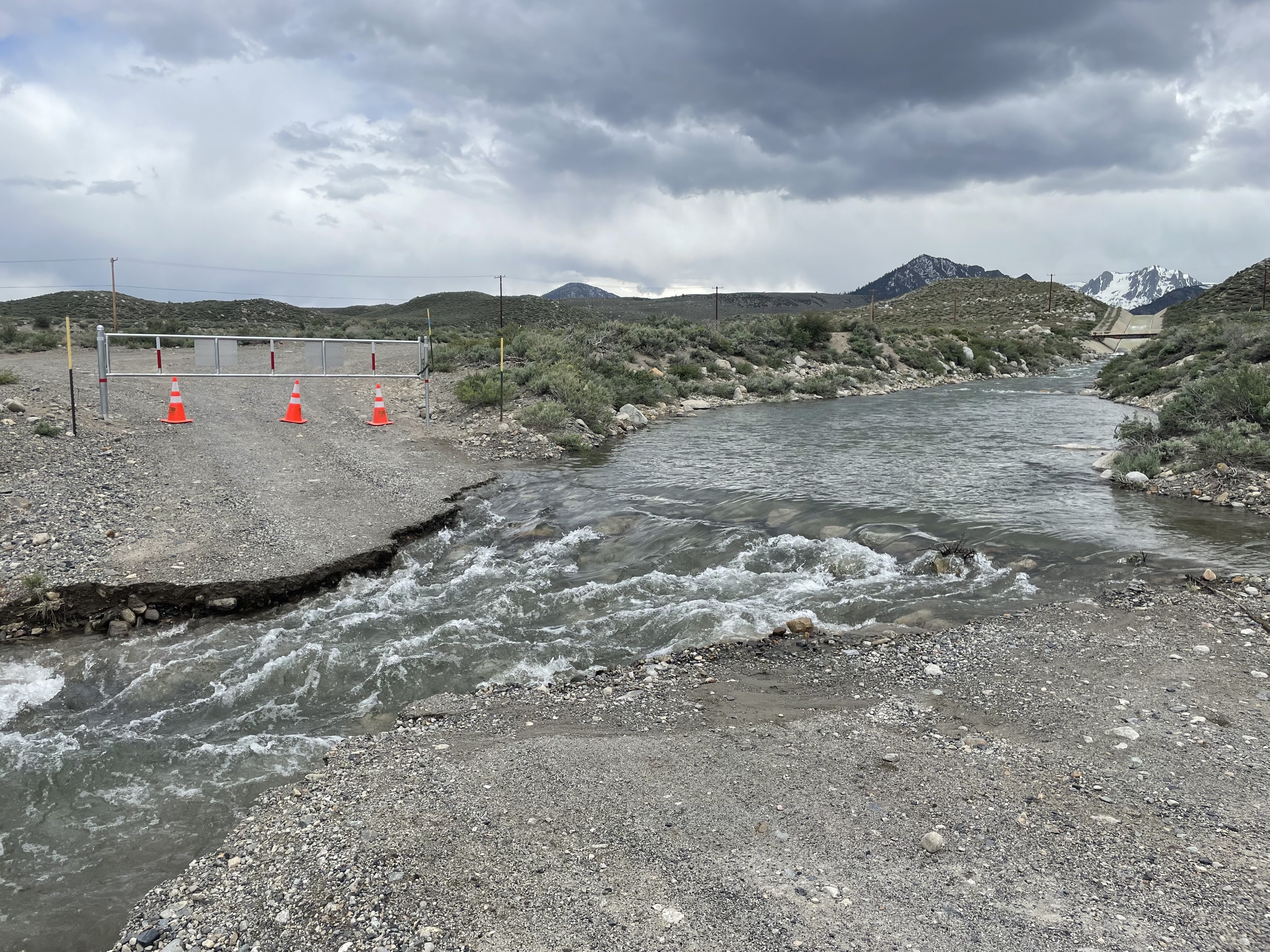
No Access to the Eastside of Grant Lake
Related Incident: INYO NATIONAL FOREST--FLOOD RESPONSE
Publication Type: Announcement
No Access to the Eastside of Grant Lake
The spillway at Grant Lake is being used again. This means access to the east side of Grant Lake is no longer possible off the June Lake Loop (Hwy 158). Users will need to access via Highway 395 and route 1S29. High clearance 4x4 recommended.
See photo & map at the top Photos Tab called GRANT LAKE ACCESS.
Also see photo & map below under related information.
![]()
June NWSReno Snowpack Water Supply Outlook
Related Incident: INYO NATIONAL FOREST--FLOOD RESPONSE
Publication Type: News
June NWS-Reno Snowpack & Water Supply Outlook
See attached “June NWS-Reno Snowpack & Water Supply Outlook” attached below under related information.
New Fire Start on Carson National Forest
Related Incident: Comanche Fire
Publication Type: News
Carson National Forest fire crews are currently on scene of a lightning-caused fire off Forest Road 137 on the El Rito Ranger District. It is located on the north slopes of Comanche Canyon and is approximately eight miles west of El Rito, NM, 11 miles north of Abiquiu, NM, and 10 miles southeast of Canjilon, NM. It was first reported around 1:45 p.m.
Named the Comanche Fire, the estimated 1/10-acre wildfire is smoldering and creeping in ponderosa, piñon pine and juniper tree stands. There is no threat to lives, homes or infrastructure.
“Fire staff are evaluating the potential of managing this naturally-caused wildfire to improve forest and watershed health,” said District Ranger Angie Krall. “We have been working with partners for years to reduce fuel loads in the Rio Chama watershed and will take advantage of this fire if the conditions and timing are suitable.”
The Comanche Fire is burning within the footprint of the Rio Chama Collaborative Forest Landscape Restoration Project, where the Forest Service and partners are working across boundaries on 3.8 million acres in Northern New Mexico and Southern Colorado. A key project goal is to restore natural fire regimes to gain numerous benefits, from improved watershed health to increased habitat quality.
Fire updates will be provided in future news releases and on InciWeb at https://inciweb.nwcg.gov/incident-information/nmcaf-comanche-fire.