
Bowles Creek Fire Update for July 30 2023
Related Incident: Bowles Creek Fire
Publication Type: News
Smoke Outlook for July 30 July 31 2023
Related Incident: Bedrock Fire
Publication Type: News
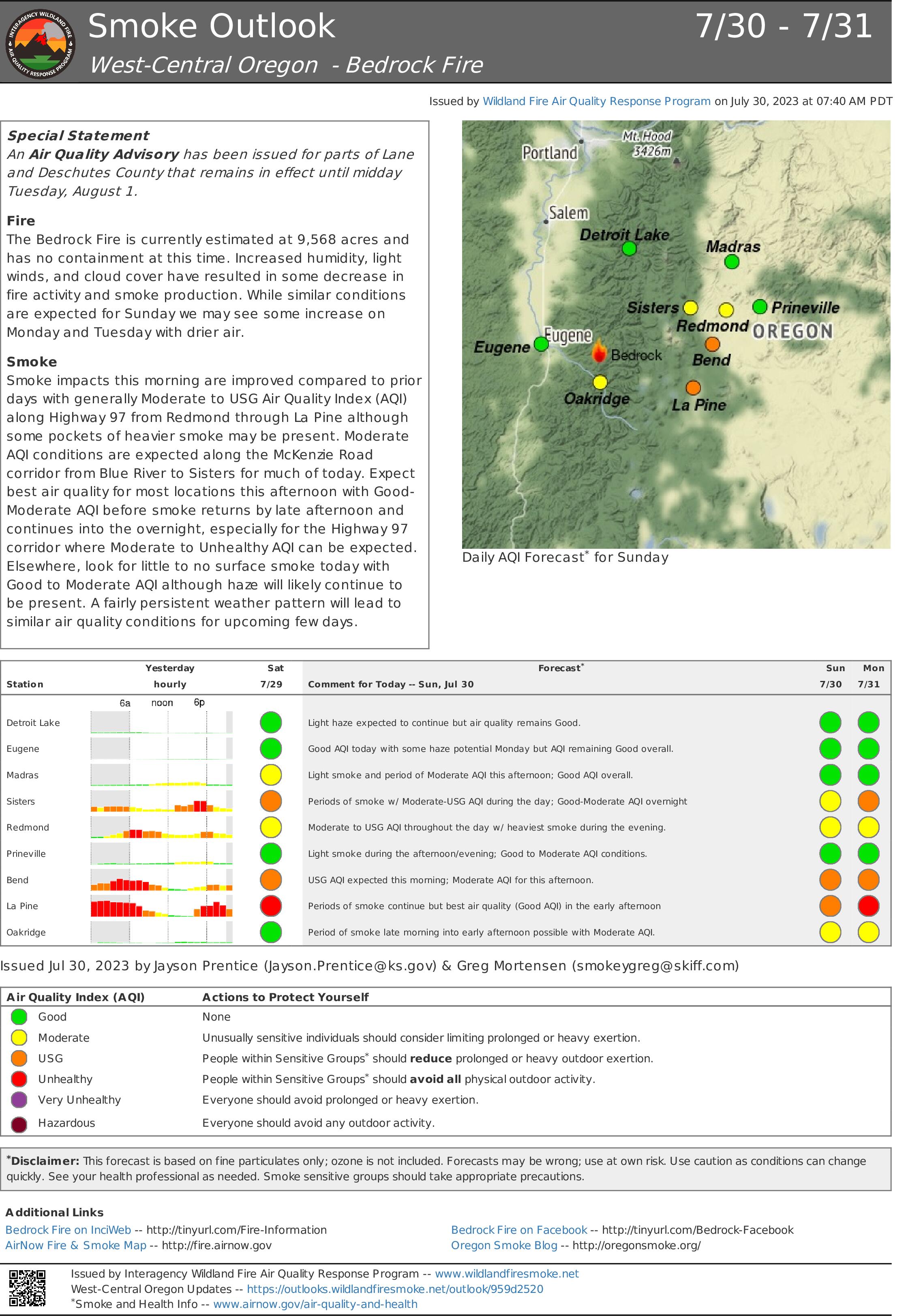
Air Resource Advisors for the Bedrock Fire have issued a Smoke Outlook for July 30 - July 31, 2023. Please see the attached files.
Colt Fire Daily Update Sunday July 30
Related Incident:
Publication Type: News
Colt Fire Fact Sheet
Montana Department of Natural Resources and Conservation Fire Protection
Lolo National Forest and Flathead National Forest Land Management
NORTHERN ROCKIES TEAM 1
INCIDENT COMMANDER: BRENT OLSON
Fire Information: 406-247-0922
Facebook: https://www.facebook.com/ColtFire
https://inciweb.wildfire.gov/incident-information/mtmts-colt-fire
Sunday, July 30, 2023 at 9:00 am
Location: 15 miles northwest of Seeley Lake, Montana
Start Date: 7/17/2023 Cause: Lightning Size: 5,475 acres Containment: 6%
Total Personnel: 568 Engines: 15 Helicopters: 5 Hand Crews: 14
KEY MESSAGE
The National Weather Service has issued a Red Flag Warning today from 3:00pm until 9:00pm. A combination of low humidity and gusty winds will lead to critical fire weather conditions.
CURRENT STATUS
Yesterday, firefighters continued firing operations, control line construction, and holding operations on three sides of the fire. Fire activity increased due to higher temperatures and lower humidity. There was fire growth yesterday but an exact figure on acres added is unavailable since there wasn’t an overnight infrared mapping flight.
On the southeast corner of the fire, crews continued firing operations to secure the fire’s edge along Forest Road 646 (Colt/Uhler Road). Firing also occurred just north of the West Fork of the Clearwater River, going east towards Forest Road 646. These areas on the fire’s southeast corner is where most of yesterday’s smoke was visible. The intent of this operation is to eliminate the unburned fuel between the active fire and the control lines. On the east side of the fire, crews working to increase the containment percentage by mopping up along Forest Road 646, moving north. Mopping up involves putting water on the fire to quench the flames, and using tools to mix the water into the burning material until extinguished. Helicopter bucket water drops were used to support burning operations. On the fire’s north side along Forest Road 906 (Beaver Creek Road) and other roads, the Heavy Equipment Task Force continued to prepare control lines and mitigate fuels along roadsides in locations that have a high probability of success to contain the fire. South Structure Protection worked on structure assessments and preparation. North Structure Protection assisted in operations along Forest Road 646 (Colt/Uhler Road) while being prepared to implement structure protection plans if conditions changed.
PLANNED ACTIONS
On the southeast corner of the fire personnel will continue firing operations and secure the line north of the West Fork of the Clearwater River and tie in with Forest Road 646 (Colt/Uhler Road). Crews will continue to hold and mop up along the eastern control lines along Forest Road 646. On the north side, crews will hold and secure the fire along Forest Road 4356 and look for opportunities for fire control line from Colt Lake to Beaver Lake. North and South Structure Protection will assist with burning operations and holding operations on the east and southeast sides of the fire. Structure Group remains ready to respond for structure protection as needed. A night shift of engines and personnel will patrol and monitor fire conditions. Helicopters and airplanes will be used to drop water and retardant on the fire as needed.
WEATHER AND FIRE BEHAVIOR
The high temperatures in the fire area on Sunday will range from 74-89 degrees, with relative humidity levels dropping as low as 16-18%. Winds will be from the west/southwest at 10-20 mph with gusts up to 25-35 mph. Warm and dry conditions will occur leading to active fire behavior. Moderate growth is expected with the fire moving through the heavy dead and down surface vegetation. Torching and spotting are possible in the subalpine fir and lodgepole pine.
EVACUATIONS AND CLOSURES
The Missoula County Sheriff’s Office Evacuation Warning and Order summary:
-Residents on Beaver Creek Road (near the summit) are under an Evacuation Warning.
-Mile marker 31 (Beaver Creek Road at the intersection of Hwy 83) south towards Seeley Lake to mile marker 27, and including residences in Rovero Flats, are under an Evacuation Order.
-Residences beginning at mile marker 27, south end of Rovero Flats, to mile marker 25.5 (the intersection of the West Fork of the Clearwater Road and Hwy 83) are under an Evacuation Warning.
-Residences on the north and south ends of Lake Inez are under an Evacuation Warning. The east side of Lake Inez, along Hwy 83, is not under any Warning or Order.
If conditions rapidly change an Evacuation Order may be issued with no prior notice or warning. Home and property owners in the surrounding area should remain vigilant and prepared. Have an evacuation plan for family, pets, and livestock; sign up for emergency alerts at Smart911.com; and be familiar with the Missoula County evacuation process and what an order and warning means by clicking on the following link: https://www.missoulacounty.us/government/public-safety/office-of-emergency-management/evacuation-information. For evolving Evacuations and Warnings please visit the Missoula County Sheriff’s Office Facebook page at https://www.facebook.com/MissoulaCountySheriffsOffice .
The Lolo and Flathead National Forests have closed several forest roads, areas, and campgrounds near the fire area for public safety. The list of current closures includes:
-Forest Road 906 (closed at Highway 83)
-Rainy Lake Campground access road 4357 (closed at Highway 83)
-Rainy Lake Campground
-Alva Lake Campground access road (closed by gate at Highway 83)
-Alva Lake Campground
-Lakeside Campground access road (closed by gate at Highway 83)
-Lakeside Campground
-Lake Inez Campground
-Forest Road 646 (closed at the junction of FSR 552; FSR 4354; Forest Road 552 (beyond the turn off to west side Lake Inez access
-Forest Road 5407 and 463 closed beyond the West Side snowmobile trailhead (these roads access the Montana Fish, Wildlife, and Parks Marshall Wildlife Management Area and Lake Marshall)
-Temporarily closing the Forest System Road loops of the Clearwater (FSR 4370 and 4353) and Richmond (FSR 667 and 720)
TEMPORARY FLIGHT RESTRICTIONS
A Temporary Flight Restriction is in place for air space over the Colt Fire (FDC 03/0291) to provide a safe environment for firefighting aircraft operating in the area. An airport closure is in place for the Condon Airstrip (FDC 07/110) for firefighting helicopter operations. Remember that temporary flight restrictions also apply to unmanned aircraft systems (UAS) or drones. If you fly, we can’t!
Midnight Fire Daily Update July 30 2023
Related Incident:
Publication Type: News
Location: Forest Service Road (FSR) #284 (Elk City Wagon Road) 1 mile east of China Point, 3 miles Northwest of Pilot Knob near Mountain House Site
Start Date: 7/10/23 Cause: Lightning Size: 179 acres Completion/Containment: 25%
Total Personnel: 169 Engines: 2 Dozers: 2 Forest Masticators: 2 Helicopters: 1
Water Tender: 6 Crews: 2
CURRENT SITUATION
Crews are working on identifying heat sources and creating contingency lines. Efforts are directed at locating smoldering, burning, or spotting embers as temperatures continue to dry vegetation. Firefighters continue to expand holding lines and good progress continues to be made.
PLANNED ACTIONS
Fire personnel will continue to improve contingency lines which include utilizing existing natural features and enhancing existing roads and trails. The water tenders will continue to supply water to ground and arial resources in this rugged dry terrain. Two crews and an engine will continue to construct direct fire line to hold and secure the fire within its existing footprint.
WEATHER AND FIRE BEHAVIOR
Temperatures will range in the upper 70’s with relatively low humidity on Sunday. Light winds will come from the northwest in the morning. There has been no new significant fire behavior on the Midnight fire however these continued dry conditions can contribute to extreme fire behavior by drying and preheating fuels.
Air quality information: AirNow Interactive Map (epa.gov)
CLOSURES AND SPECIAL MESSAGES
There are currently no closures in place, but firefighting traffic is expected to be heavy along FSR # 244 (Lighting Creek Road) and FSR# 284 (Elk City Wagon Road) between China Point and Lytle Cow Camp. Forests users are encouraged to slow down and use extra caution while with heavy fire traffic and dust on roads. Fire Management Officials urge the traveling public to please avoid this area both on the ground and in the air. We still have a long fire season ahead, please recreate responsibly.
Actualizacin del Incendio Lowline Domingo 30 de Julio 2023
Related Incident: Lowline Fire
Publication Type: News
Equipo de Gestión de Incidentes del Complejo del área de las Montañas Rocosas 1
Dan Dallas, Comandante del Incidente
Teléfono de Información: 970-648-4470 (publico), 970-765-7123 (medios de comunicación)
Correo electrónico: 2023.lowline@firenet.gov
Horario: 8 a.m. – 8 p.m.
Situación Actual: Actualmente, el incendio Lowline mide 1096 acres y esta 7% contenido. Los bomberos realizaron operaciones de contrafuego en porciones del perímetro del fuego principal para reducir el combustible entre la línea de control y el fuego principal. Esto crea una zona libre de combustible que es efectiva para detener la propagación del fuego. Mientras tanto, la construcción de la línea de fuego continuó en otras partes del incendio, y las fuerzas de protección de estructuras realizaron evaluaciones de estructuras y trabajos de preparación cerca del flanco sur del incendio. Un turno de noche patrulló las áreas quemadas para asegurarse de que no ocurriera ninguna actividad de incendio inesperada. La lluvia cayó sobre el fuego durante unos 10 minutos durante la noche.
En la División A, las operaciones de ataque aéreo realizadas por helicóptero eliminaron los combustibles pesados de coníferas de una parte del lado este del incendio. El trabajo con bulldozers y cuadrillas de mano continuó para ampliar y mejorar las líneas de fuego. Hoy, las cuadrillas patrullarán y retendrán lo que se ha quemado, y se pueden ejecutar áreas adicionales de quema, si el clima lo permite, durante las horas de la mañana antes de que lleguen las tormentas eléctricas. Esto incluye quemar a lo largo de una línea de fuego indirecta en el lado norte del incendio. Humo adicional y aeronaves serán visibles durante estas operaciones de quema.
Ayer también se quemó un larguero de madera en la División Z para eliminar combustibles potencialmente problemáticos. Hoy, las cuadrillas se concentrarán en patrullar, sostener y limpiar este segmento de la línea de fuego. Limpiar significa extinguir por completo cualquier punto crítico que quede cerca de la línea de fuego para garantizar que el fuego no cruce la línea hacia los combustibles no quemados.
Ayer, en la División Y, un vehículo de bombero y su tripulación comenzaron a subir por la cresta que se extiende hacia el oeste desde el incendio para prepararlo para su uso como línea de contención indirecta. El equipo comenzó el trabajo de preparación en los tramos inferiores de la cresta para facilitar la construcción de la línea de fuego. Este mismo trabajo continuará hoy.
Un equipo de la División W comenzó a trabajar hacia el oeste desde la separación de la División A, explorando opciones de línea de contención y comenzando la construcción de una línea de fuego indirecta hacia el desierto. Este trabajo continuará hoy.
Condiciones Climáticas y de Combustibles:
El clima para los próximos días seguirá siendo templado con tendencia al calentamiento. Los vientos generalmente serán relativamente tranquilos. Hay probabilidad de lluvia en los próximos días. Algunas tormentas pueden tener fuertes lluvias humectantes. Existe la posibilidad de vientos fuertes cerca de la actividad de tormentas eléctricas.
Los combustibles en el área del incendio son coníferas mixtas con un componente pesado de muerte y caído, que se transforman en pasto y arbustos en las elevaciones más bajas. El potencial de propagación del fuego es de moderado a alto. El fuego no se propaga en los combustibles herbáceos vivos, pero las coníferas mixtas se queman fácilmente.
Evacuaciones, Cierres, y Restricciones de Incendios:
Se han realizado evacuaciones obligatorias en los drenajes de Squirrel Creek y Mill Creek. Para obtener información específica sobre evacuación, consulte Manejo de emergencias del condado de Gunnison en www.gunnisoncounty.org. Puede registrarse para recibir alertas de emergencia en sus teléfonos u otros dispositivos en: https://bit.ly/3QhZVZg.
Se ha implementado cierre de áreas, caminos y senderos en tierras del Sistema Forestal Nacional cerca del incendio. Para obtener detalles, consulte este enlace: https://www.fs.usda.gov/Internet/FSE_DOCUMENTS/fseprd1126172.pdf. Las carreteras del condado en la vecindad del incendio están bloqueadas. Se le pide al público que se adhiera al cierre por salud pública y seguridad de nuestro personal de bomberos.
Actualmente no hay restricciones de incendios en el condado de Gunnison. Si se implementan restricciones, se publicarán en este sitio: https://westslopefireinfo.com/gunnison-county/.
Los incendios forestales son una zona de exclusión aérea para aeronaves no autorizadas, incluidos los drones. Si tu vuelas, nosotros no podemos. Para obtener más información, visite http://knowbeforeyoufly.org.
Estadísticas del Incendio Lowline:
Tamaño: 1096 acres
Contenido: 7%
Personal: 322
Locación: 14 mi. NNW de Gunnison, CO
Reportado: 8:00 am 26 de Julio, 2023
Causa: Relámpago
Para mas Informaccion:
Línea Telefónica : 970-648-4470 (public), 970-765-7123 (media)
Correo electrónico: 2023.lowline@firenet.gov
InciWeb: https://inciweb.wildfire.gov/incident-information/cogmf-lowline-fire
Facebook: www.facebook.com/GMUGFireInfo
Grasshopper Fire 900 am Updated July 30 2023
Related Incident: Grasshopper Fire
Publication Type: News
July 30, 2023
Size: 396 acres
Containment: 95%
Date Started: July 29, 2023
Cause: undetermined
Texas A&M Forest Service resources completed containment line construction, crews will continue to monitor the fire throughout the day, and all evacuation orders and road closures have been lifted as of yesterday evening.
Racetrack Fire Update July 30 2023
Related Incident: 2023 Racetrack Fire
Publication Type: News
Racetrack Fire Update - July 30, 2023
The will be the last Racetrack Fire Update.
Location: North of Highway 169, south of Crater Mountain near the community of Cherry
Start Date: July 23, 2023
Size: 405 acres
Cause: Lightning
Containment: 80%
Resources: 3 Engines
Fire behavior: Low fire behavior
Types of vegetation in the area (aka fuels): Grass, Brush
SUMMARY: The Racetrack Fire is predicted to be 100% contained tonight at 6:00 pm with a secure perimeter. Although there is no threat of fire spread or potential growth; firefighters will continue to patrol and monitor containment lines by ground and air. Light smoke may be visible at times as isolated interior fuels continue to burn and smolder.
Today monsoon storms are expected to develop in the afternoon with a high likelihood of wetting rains occurring in the incident area. Temperatures will be slightly cooler in the upper 80s to mid-90s.
FIRE RESTRICTIONS: The entire Prescott National Forest is under Stage 1 Fire Restrictions which prohibits building, maintaining, attending, or using a fire, campfire, or stove fire, including charcoal and briquettes, outside a structure that is provided by the Forest Service within designated areas for portions of the forest. Under these restrictions, discharging a firearm, air rifle or gas gun, except for persons engaged in legal hunting activities, is prohibited on the Prescott National Forest. Fireworks and the use of exploding targets are always prohibited year-round on national forests.
Grapevine Fire Closure: Prescott National Forest Roads along the route beginning at the junction of Forest Road 104 and Forest Road 143 and extending ¼ mile on either side of Forest Road 413 to the junction of Forest Road 132 then along Forest Road 132 to the junction of County Road 75, Cherry Creek Road.
For fire information please call (928) 925-1111
Grapevine Fire Daily Update July 30 2023
Related Incident:
Publication Type: News
Fire Crews Continue to Build Control Lines to Protect Properties
Location: Mingus Mountain, Verde Ranger District (T14N, R2E, SEC 4), Approximately 10 miles east of Prescott Valley; 2 miles south of Mingus Spring Ranch
Start Date: July 21, 2023
Size: Approximately 1049 acres
Percent Contained: 0%
Cause: Lightning
Vegetation: Brush, Timber and Short Grass
Resources: 2 Type 1 Crews, 5 Type 2 Crews, 18 Engines, 3 Dozers, 4 Helicopters and additional support personnel
Number of Personnel Assigned: 375
Update: A combination of hand tools and saws were used to build much needed control lines along the west side of the fire by crews. A major protection effort was completed by dozers along the north and east boundaries between the Prescott National Forest and the community the Whitehorse. Control lines were also constructed along the west side of the fire at Shylock Mine by crews using hand tools and power saws. Efforts to complete control lines are ongoing at the Mingus Mountain Academy using hand tools, saws, and heavy equipment. Headway is being made to protect the 4H Camp with hand crews improving existing control lines and building new lines. A line has been established along the south side of the Brindle Pup Mine.
Community Response: Large Animal Shelter & Emergency Readiness known as LASER is a nonprofit organization whose mission is to provide safe shelter for barn animals and provide information for emergency preparedness. Partnering with Yavapai County Emergency Management in Prescott the trained volunteers were called to action on July 23, 2023 with the evacuation of Whitehorse residents while 38 volunteers remained around the clock taking care of the resident’s animals. The volunteers stayed on duty until the last of the animals went home on July 29, 2023. Altogether the volunteers put in over 600 hours of service caring for 13 equines, 7 goats, 3 pigs, and 69 fowl plus kept in communication with the owners, letting the family know the status of their animals. In addition to LASER we have many volunteer organizations that help during emergency situations including Red Cross, Sheriff’s Jeep Posse and Animal Disaster Services.
Closures: Prescott National Forest Roads along the route beginning at the junction of FR104 and FR143 and extending ¼ mile on either side of FR413 to junction of FR132 then along FR132 to the junction of County Rd 75, Cherry Creek Road.
Fire Restrictions: The entire Prescott National Forest is under Stage 1 Fire Restrictions which prohibits building, maintaining, attending, or using a fire, campfire, or stove fire, including charcoal and briquettes, outside a structure that is provided by the Forest Service within designated areas for portions of the forest. Under these restrictions, discharging a firearm, air rifle or gas gun, except for persons engaged in legal hunting activities, is prohibited on the Prescott National Forest. Fireworks and the use of exploding targets are always prohibited year-round on national forests.
For current evacuation information contact the Yavapai County Sheriff’s Office at 928-771-3260 or follow them at https://www.facebook.com/YavapaiCountySheriff.
For fire information please call (928) 925-1111; or stay up to date on Prescott National Forest news by checking the Prescott NF website and following us on Facebook and Twitter.
Lowline Fire Morning Update Sunday July 30 2023
Related Incident: Lowline Fire
Publication Type: News
Rocky Mountain Complex Incident Management Team 1
Dan Dallas, Incident Commander
Information Phone: 970-648-4470 (public), 970-765-7123 (media)
Email: 2023.lowline@firenet.gov
Information Staffing Hours: 8 a.m. to 8 p.m.
Current Situation: The Lowline Fire is currently 1096 acres and is 7% contained. Firefighters conducted burnout operations on portions of the fire perimeter yesterday to remove fuels between the fire edge and control lines. This creates a fuel-free zone that is effective in stopping fire spread. Meanwhile, fireline construction continued on other portions of the fire, and structure protection forces performed structure assessments and preparation work near the fire’s southern flank. A night shift patrolled the burned areas to ensure no unexpected fire activity occurred. Rain fell on the fire for about 10 minutes overnight.
In Division A, aerial firing operations performed by helicopter removed heavy conifer fuels from a portion of the fire’s eastern side. Work with dozers and hand crews continued to extend and improve firelines. Today, crews will patrol and hold what has been burned, and additional areas of burnout may be executed, weather permitting, during the morning hours before thunderstorms arrive. This includes burning along an indirect fireline on the north side of the fire. Additional smoke and aircraft will be visible during these burn operations.
A timber stringer in Division Z was also burned yesterday to remove potentially problematic fuels. Today, crews will focus on patrolling, holding, and mopping up this segment of fireline. Mopping up means fully extinguishing any remaining hotspots near the fireline to ensure the fire does not cross the line into unburned fuels.
In Division Y yesterday, an engine and crew began working its way up the ridge extending westward from the fire to prepare it for use as an indirect containment line. The crew began preparation work on the lower reaches of the ridge to facilitate fireline construction. This same work will continue today.
A crew in Division W began working its way west from the Division A break, scouting containment line options and beginning construction of indirect fireline towards the Wilderness. This work will continue today.
Weather & Fuel Conditions:
Weather for the next few days will continue to be mild with a warming trend. Winds will generally be relatively calm. There is a chance of rain over the next several days. Some storms may have heavy wetting rains. There is a possibility of high winds near thunderstorm activity.
Fuels in the fire area are mixed conifer with a heavy dead and down component, transitioning to grass and shrubs at the lower elevations. Potential for fire spread is moderate to high. Fire is not spreading in live herbaceous fuels, but mixed conifer is readily burning.
Evacuations, Closures, and Fire Restrictions:
Mandatory evacuations are in place in the Squirrel Creek and Mill Creek drainages. For specific evacuation information, see Gunnison County Emergency Management at www.gunnisoncounty.org. You may sign up to receive emergency alerts on your phones or other devices at: https://bit.ly/3QhZVZg .
An area, road, and trail closure has been implemented on National Forest System lands near the fire area. For specifics see this link: https://www.fs.usda.gov/Internet/FSE_DOCUMENTS/fseprd1126172.pdf . BLM has implemented a temporary closure in the fire vicinity. For details see this link: www.blm.gov/programs/public-safety-and-fire/fire-and-aviation/regional-information/colorado/southwest-district . County Roads in the fire vicinity are barricaded. In the interest of public safety, fire officials ask visitors to be aware of fire traffic and avoid the area.
There are currently no fire restrictions in Gunnison County. Should restrictions be implemented, they will be posted at this site: https://westslopefireinfo.com/gunnison-county/ .
Wildfires are a no-fly zone for unauthorized aircraft, including drones. If you fly, we can’t. For more information, visit http://knowbeforeyoufly.org.
Lowline Fire Statistics:
Size: 996 acres
Containment: 7%
Total Personnel: 322
Location: 14 mi. NNW of Gunnison, CO
Reported: 8:00 am July 26, 2023
Cause: lightning
For More Information:
Information Phone: 970-648-4470 (public), 970-765-7123 (media)
Email: 2023.lowline@firenet.gov
InciWeb: https://inciweb.wildfire.gov/incident-information/cogmf-lowline-fire
Facebook: www.facebook.com/GMUGFireInfo
Diamond Fire Tonto Daily Update 07302023
Related Incident:
Publication Type: News
Location: Southwest of Sunflower Start Date: 07/22/2023 Cause: Under investigation
Size: 5,150 acres Containment: 0% Total Personnel: 354
Resources Continue to Hold Diamond Fire Amid Thunderstorm Activity
OPERATIONAL UPDATE
Yesterday resources held the Diamond Fire amid overnight thunderstorms. Ground crews monitored conditions around Sunflower and State Route 87. Managers are curating plans for containment lines along the eastern side of the fire with an emphasis around communities. Equipment continued improving access north of Sunflower, while dozers prepped the 1333 road to the south as a holding feature, if needed. The southwest portion of the fire continues to be active, but moving at a slow rate of spread. Access remains difficult for the western portion of the fire, but air resources cooled hotspots in these areas.
Today’s operational plan will be an extension from yesterday. Ground resources will begin shifting to the south-southwestern portion of the fire. Crews working around Sunflower will continue to monitor conditions and extinguish any visible smokes. Mastication equipment will be removing fuels along the Old Beeline Highway. Resources will continue scouting the Alder Creek drainage for potential burning in the future, if needed.
Temperatures are expected to remain in the triple digits today with relative humidity increasing slightly. Winds will be southwest at less than 20 miles per hour. Several models indicate increased thunderstorm activity in and around the fire area. These thunderstorms may bring strong, erratic outflow winds and an increased potential for precipitation.
CLOSURES AND EVACUATIONS
The National Forest has issued a closure order for the fire area to provide public health and safety due to firefighting operations. Forest Road 627, west of State Route 87, remains closed to the general public per the Forest Area Closure. Refer to Inciweb for the closure order in entirety. Although not currently planned, there is the possibility for a State Route 87 closure. If you have travel plans in the area, pay close attention to https://az511.gov and our Facebook page for the most up-to-date road closure information. https://www.facebook.com/diamond.fire.tonto
The communities of Sunflower, Cross F Ranch, and Diamond Ranch are currently under the GO evacuation notice. Please visit https://tinyurl.com/nhv6uyyt for further information. An interactive evacuation map link is available on both Inciweb and Facebook: https://tinyurl.com/54tbdhm2
RESTRICTIONS
There is a temporary flight restriction over the fire area, which includes the use of drones (UAS). Flying a drone over a fire area is dangerous to pilots and will cause air operations to shut down. Flying a drone within the restricted area is also illegal.
The Tonto National Forest is currently under Stage 1 Fire Restrictions. Please see https://www.fs.usda.gov/alerts/tonto/alerts-notices/?aid=81280 for more information.