
Lowline Fire Update Monday July 31 2023 900 am
Related Incident: Lowline Fire
Publication Type: News
Rocky Mountain Complex Incident Management Team 1
Dan Dallas, Incident Commander
Information Phone: 970-648-4470 (public), 970-765-7123 (media)
Email: 2023.lowline@firenet.gov
Information Staffing Hours: 8 a.m. to 8 p.m.
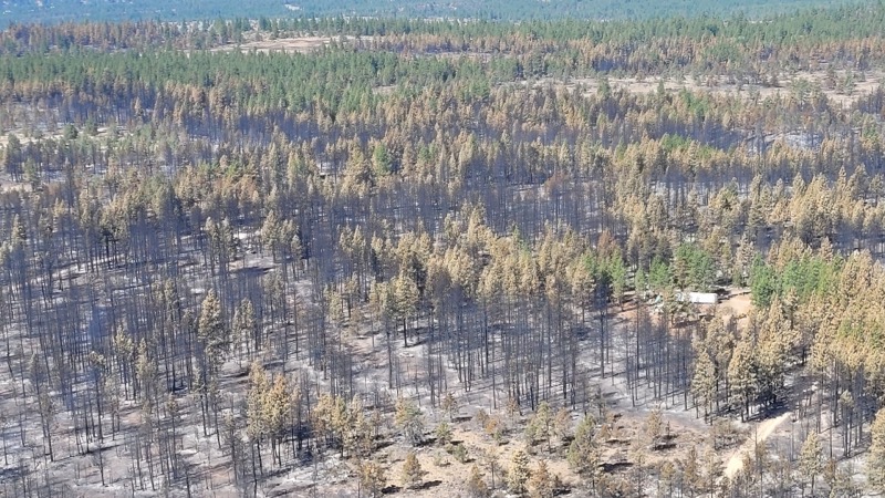
Current Situation: The Lowline Fire is currently 1331 acres and is 15% contained. Changing weather and its effects on the fire and our suppression activities was the predominant theme yesterday and continues into today. Aerial and hand-ignited burnout operations began yesterday morning, but a thunderstorm passed over the southern end of the fire around noon, causing heavy clouds, rising humidity, and minimal rain. This combination was sufficient to make burning marginally effective, those operations were mostly curtailed in early afternoon, a time when burning conditions are often optimal. Crews continued other suppression actions throughout the remainder of the day. They will resume burning to the extent possible today as conditions allow.
In Division A, a helicopter conducting aerial ignition supplemented by hand ignition crews on the ground began burning out the heavy fuels between the north end of the fire and indirect fireline still further north. This work progressed well until a thunderstorm arrived over the fire, at which time the aerial operations were shut down for safety. Ground crews continued lighting fuels and progressed westward along a ridge well into Division W. Weather permitting, this work will continue today with focus on filling in any unburned gaps and extending the burn further to the west.
Hand-ignited burning occurred in Division Z yesterday, but holding, patrolling, and mopping up along existing firelines were the primary activities. The same work will continue today. Structure Protection Group worked on structure assessments and mitigation work including sprinkler deployments on the south end of the fire. Structure assessment and preparation will progress eastward today.
In Division Y, an engine crew continued fireline prep and holding of a small area burned Saturday. This will continue today. The strategy is to follow the progression of the fire westward below a ridgeline, burning out only when needed to keep pace with the fire preventing it from crossing the ridge towards the south.
Weather & Fuel Conditions:
A thunder cell passed over the southern end of the fire yesterday, producing heavy clouds, rising humidity, but little rain. Today will see additional storms moving through. Temperatures will be slightly cooler and humidity slightly higher than yesterday. There is an 85% chance of rain today with up to 0.15” of precipitation, depending on the storm’s path. Wednesday will also likely be wet, but a drying trend begins on Thursday, with much warmer and drier conditions through next weekend.
Fuels in the fire area are mixed conifer with a heavy dead and down component, transitioning to grass and shrubs at the lower elevations. Fire spread in conifer fuels is moderate to high. Live herbaceous fuel moistures are stopping spread in the grass and sagebrush. Dead and down fuels are exceptionally dry, and mixed conifer is readily burning with group torching and short crown runs. Higher moisture levels reduced fire behavior yesterday, and predicted rains should moderate conditions for a few days.
Evacuations, Closures, and Fire Restrictions:
Mandatory evacuations are in place in the Squirrel Creek and Mill Creek drainages. For specific evacuation information, see Gunnison County Emergency Management at www.gunnisoncounty.org. You may sign up to receive emergency alerts on your phones or other devices at: https://bit.ly/3QhZVZg .
An area, road, and trail closure has been implemented on National Forest System lands near the fire area. For specifics see this link: https://www.fs.usda.gov/Internet/FSE_DOCUMENTS/fseprd1126172.pdf . BLM has implemented a temporary closure in the fire vicinity. For details see this link: www.blm.gov/programs/public-safety-and-fire/fire-and-aviation/regional-information/colorado/southwest-district . County Roads in the fire vicinity are barricaded. In the interest of public safety, fire officials ask visitors to be aware of fire traffic and avoid the area.
There are currently no fire restrictions in Gunnison County. Should restrictions be implemented, they will be posted at this site: https://westslopefireinfo.com/gunnison-county/ .
Wildfires are a no-fly zone for unauthorized aircraft, including drones. If you fly, we can’t. For more information, visit http://knowbeforeyoufly.org.
Lowline Fire Statistics:
Size: 1331 acres
Containment: 15%
Total Personnel: 419
Location: 14 mi. NNW of Gunnison, CO
Reported: 8:00 am July 26, 2023
Cause: lightning
For More Information:
Information Phone: 970-648-4470 (public), 970-765-7123 (media)
Email: 2023.lowline@firenet.gov
InciWeb: https://inciweb.wildfire.gov/incident-information/cogmf-lowline-fire
Facebook: www.facebook.com/GMUGFireInfo
Grapevine Fire Daily Update July 31 2023
Related Incident:
Publication Type: News
Grapevine Fire
July 31, 2023 – Daily Update
Massive Heavy Equipment Assists Fire Crew in Building Control Lines
Location: Mingus Mountain, Verde Ranger District (T14N, R2E, SEC 4), Approximately 10 miles east of Prescott Valley; 2 miles south of Mingus Spring Ranch
Start Date: July 21, 2023
Size: Approximately 1049 acres
Percent Contained: 0%
Cause: Lightning
Vegetation: Brush, Timber and Short Grass
Resources: 2 Type 1 Crews, 5 Type 2 Crews, 18 Engines, 3 Dozers, 4 Helicopters and additional support personnel
Number of Personnel Assigned: 367
Update: The fire crews accomplished building control lines around the Old Cherry community while also connecting the lines east of the Brindle Pup Mine. Efforts to complete control lines are continuing at the Mingus Mountain Academy using hand tools, saws, and heavy equipment. A combination of hand tools and saws were used to build much needed control lines along the west side of the fire by crews. Control lines are continuing to be constructed along the west side of the fire at Shylock Mine by crews using hand tools and power saws. Progress is being made to protect the 4H Camp with hand crews improving existing control lines and building new lines. The monsoons are continuing to be a safety concern for fire personnel as the push forward building lines. Due to terrain and limited access; firefighters continue to identify hazards as they begin to safely suppress the fire.
Heavy Equipment: Forest Service contracts companies from all over country to work Wildland Fires. One piece of contracted equipment is a boom mounted masticator. This heavy equipment that is used to clear the vegetation 20 feet on both sides of the road creating a control line. This heavy equipment will cut vegetation within two inches of the ground and as high as 24 feet leaving behind wood chips and small branches to help with erosion and enrich the soil. Multiple masticators help the firefighting effort in challenging terrain, steep slopes and tight areas.
Closures: Prescott National Forest Roads along the route beginning at the junction of FR104 and FR143 and extending ¼ mile on either side of FR413 to junction of FR132 then along FR132 to the junction of County Rd 75, Cherry Creek Road.
Fire Restrictions: The entire Prescott National Forest is under Stage 1 Fire Restrictions which prohibits building, maintaining, attending, or using a fire, campfire, or stove fire, including charcoal and briquettes, outside a structure that is provided by the Forest Service within designated areas for portions of the forest. Under these restrictions, discharging a firearm, air rifle or gas gun, except for persons engaged in legal hunting activities, is prohibited on the Prescott National Forest. Fireworks and the use of exploding targets are always prohibited year-round on national forests.
For current evacuation information contact the Yavapai County Sheriff’s Office at 928-771-3260 or follow them at https://www.facebook.com/YavapaiCountySheriff.
For fire information please call (928) 925-1111; or stay up to date on Prescott National Forest news by checking the Prescott NF website and following us on Facebook and Twitter.
Bowles Creek Fire Update for July 31 2023
Related Incident: Bowles Creek Fire
Publication Type: News
Diamond Fire Tonto Daily Update 07312023 Diamond Fire Resources Increase Containment to 9
Related Incident:
Publication Type: News
Location: Southwest of Sunflower Start Date: 07/22/2023 Cause: Under investigation
Size: 5,101 acres Containment: 9% Total Personnel: 365
Resources Continue to Hold Diamond Fire Amid Thunderstorm Activity
OPERATIONAL UPDATE
Yesterday crews increased containment on the Diamond Fire to 9% with minimal growth in overall acreage. Along the north, east, and southern portions of the fire, ground crews continued to utilized helicopters to cool hotspots. Around the community of Sunflower, engines and crews mopped up hotspots along the fire’s edge, thus securing containment lines around the community. Dozers continued to improve access for crews and engines in rugged terrain. On the western portion of the fire, resources refined plans for potential burnout operations, if needed, and employed helicopters to aid in cooling active areas around Maverick Springs.
Today’s operational plan will build upon good work completed yesterday. Engines will continue monitoring the containment line around Sunflower, while additional ground resources will push further north along the 344 road to extend containment in that direction. Dozers will continue access improvement north of Sunflower and the masticator will remove fuels along the Old Beeline Hwy. Crews will continue monitoring the western portion of the fire with a crew shuttle planned into Maverick Springs to begin direct attack on that section of line that is east of Maverick Mountain.
Temperatures are expected to decrease a bit today with an increase in relative humidity resulting from area thunderstorm activity. Winds will be southwest at less than 20 miles per hour. Although there is an increase in the probability of precipitation, it remains localized to thunderstorm activity. These storms may bring strong, erratic outflow winds which could impact fire activity.
CLOSURES AND EVACUATIONS
The Tonto National Forest has issued a closure order for the fire area to provide public health and safety due to firefighting operations. If you have travel plans in the area, pay close attention to https://az511.gov and our Facebook page for the most up-to-date road closure information. https://www.facebook.com/diamond.fire.tonto
The evacuation notice for the communities of Sunflower, Cross F Ranch, and Diamond Ranch has downgraded from GO to SET. Please visit https://tinyurl.com/nhv6uyyt for further information. An interactive evacuation map link is available on both Inciweb and Facebook: https://tinyurl.com/54tbdhm2
RESTRICTIONS
There is a temporary flight restriction over the fire area, which includes the use of drones (UAS). Flying a drone over a fire area is dangerous to pilots and will cause air operations to shut down. Flying a drone within the restricted area is also illegal.
The Tonto National Forest is currently under Stage 1 Fire Restrictions. Please see https://www.fs.usda.gov/alerts/tonto/alerts-notices/?aid=81280 for more information.
Hayden Fire Update July 31 2023
Related Incident:
Publication Type: News
A community meeting is scheduled for tomorrow August 1, 7 PM at the community center in Leadore.
Acres: 18,085
Containment: 5%
Personnel: 702
Summary: The Hayden Fire started on Wednesday, July 19th, 2023, at approximately 11:30 am. The fire is located in the Lemhi Range, 18 miles west of Leadore, Idaho. The Hayden Fire is a full suppression fire. Firefighters are working long hours every day to contain the fire as quickly as they can, impacting the fewest acres possible.
Weather: THE RED FLAG WARNING CONTINUES FOR TODAY. Poor humidity recoveries overnight continue to result in critical fire weather. Winds will be lower than yesterday, and the sky cover will be mostly to partly cloudy.
Actions: Yesterday, crews made good progress on connecting and strengthening primary control lines in the northern, eastern, and southern portion of the fire. All fire remains within primary containment lines. Today, igniting fuels will widen primary containment lines. Fire will also be used to burn pockets of unburned fuel to reduce the chance of group tree torching and spotting over control lines.
Helicopters dipping retardant from the mobile retardant base are supporting firefighters on the ground as they prepare and enhance the primary control lines. Helicopters allow for precise retardant placement to minimize impacts to the watershed and its users. In three areas of the fire, Bear Valley Road, west of Alder Creek and Jack Smith Gulch, firefighters have made excellent progress resulting in 5% containment on the fire.
Important Information: The Lemhi County Sheriff’s Department in coordination with the Salmon-Challis National Forest and Great Basin Team 7 have pre-identified evacuation zones. They will be implemented using the “Ready, Set, Go” terminology, for more information please visit the Lemhi County website at lemhicountyidaho.org.
Stage 1 fire restrictions are in effect on the Salmon-Challis National Forest (SCNF), Idaho Department of Lands, and Bureau of Land Management jurisdiction. For more information, please visit the Salmon-Challis National Forest’s Alerts and Notices webpage.
The Salmon-Challis National Forest has an area closure order in place to help protect firefighter and public safety. Maps and additional information are available on the Alerts and Notices SCNF website. Risk to responders and public safety remains the highest priority for the incident management team.
30 de Julio 2023 Informe vespertino del Incendio Flat
Related Incident: Flat Fire
Publication Type: News
30 de Julio, 2023
Información vespertina del Incendio Flat
Extension: 25,572
Inicio: 15 de Julio, 2023
Origen: 2 millas Sureste de Agness, OR
Contencion: 14%
Causa: Error Humano, Bajo Investigación
Personal: 1,941
Recursos: 53 camiones de bomberos l 50 escuadrillas de bomberos l 8 buldóceres l 35 cisternas l 8 máquinas masticadoras l12 helicópteros
El Progreso de hoy: En la esquina Suroeste del incendio, los bomberos utilizaron igniciones aéreas con el objetivo de quemar la vegetación en el interior de la línea de fuego. Las operaciones incluyeron el uso del Sistema Aéreo sin personal (UAS) y herramientas basadas en tierra para quemar la vegetación exactamente en la zona interna a lo largo de la carretera Forestal (FR) 3680 al Sur de Game Lake. Los helicópteros usaron un dispensador esférico de plástico PSD) para las operaciones aéreas de incendio más allá de la parte interna del fuego y de esta manera, se logró mover el área principal del incendio al Suroeste hacia las líneas de fuego. Esta estrategia mueve la parte principal del incendio hacia la línea de fuego ya preparada a unas condiciones más controladas y favorables.
Se continua con las operaciones de incendio a lo largo de la línea de fuego y cerca de Game Lake reduciendo la vegetación extendida sobre la línea que cierra la brecha restante en dicha área. Se siguen realizando patrullaje sobre la línea Noreste del incendio con la finalidad de eliminar cualquier espacio de emanación de calor. Las cuadrillas de bomberos están trabajando arduamente en el mejoramiento de las líneas alternativas de contención al Oeste del incendio sobre las carreteras forestales 3313, 1503 y 3680.
Reunión Comunitaria.
Se estará llevando a cabo una reunión para la comunidad el lunes 31 de Julio, en la cafetería de la escuela secundaria en Brookings, a las 6:00pm. La dirección es: 625 Pioneer Rd, Brookings, OR 97415. La reunión también será transmitida en vivo en la página de Facebook del Incendio Flat: facebook.com/flatfireoregon2023
Evacuaciones: Permanece en efecto el Nivel de Evacuación 1 “Listos” para las áreas en el lado Norte de Rogue River en Agness hacia Illahe Lodge y a lo largo del corredor de Rogue River desde el campamento de Quosatana Creek hasta el área de Agness. Incluyendo las zonas de Spud Road, Old House Creek Road y Oak Flat.
El área Este, cercana a Agness permanece a un Nivel de Evacuación 2 debido al peligro extremado que el incendio representa.
La Oficina del Alguacil para la ciudad de Curry continuara coordinándose con el Grupo para el Manejo de Incidente de Incendio y serán los responsables de notificar a los residentes afectados por el incendio acerca de las razones para cambiar los niveles de evacuación.
La ciudad de Curry está enviando noticias de evacuación utilizando el sistema Everbridge. Usted puede registrarse en: https://www.co.curry.or.us/.../emergency.../index.php
Condiciones climáticas: El pronóstico del tiempo avisa un pequeño incremento en la temperatura y vientos para el lunes.
Impacto del humo: Pronósticos en la presencia del humo, puede encontrarse en la página web: https://outlooks.airfire.org/outlook/en/b74901f7
Cierres de áreas: El Bosque Nacional de Rogue River-Siskiyou, emitio una nueva orden de cierre el día 29 de Julio para ciertas áreas incluyendo senderos, carreteras y parte del rio Illinois. Esta orden de cierre abarca Oak Flat Campground, Game Lake Campground, Wildhorse Campground y el Lookout Recreacional de Snow Camp. La carretera forestal de Chetco River Road (FR 1376) y la de Chetco/Pistol River Road (FR 1407) actualmente se encuentran cerradas. Esta nueva orden de cierre permitirá al público el acceso a el área para nadar de Big Rock en el Rio Illinois.
Puede encontrar información actualizada en : https://tinyurl.com/bdzbae69
Orden de restricción: Se han establecido Restricciones en el área. Para más información:
Se pronostican condiciones climáticas anormalmente secas y temperaturas calientes en una manera persistente a través de Oregon y Washington. Estas áreas ya presentan vegetación más seca de lo normal. Por favor siga todas las restricciones de incendio, especialmente después de observarse a nivel regional un incremento significativo en incendios causados por humanos
Utilice supresores de chispas que estén funcionando apropiadamente y permanezca en senderos y caminos designados. No se parquee, descanse o maneje sobre vegetación inflamable. Su vehículo podría iniciar un incendio forestal.
York Fire Update 73023 900pm
Related Incident: 2023 - York Fire
Publication Type: News
California Interagency Incident Management Team 13 was briefed on the significant ongoing firefighting efforts for the York fire this evening. The team will be taking command of the fire on 7/31/23 at 8:00am and will assume operational control and coordination of all firefighting resources and personnel on the ground.
The York Fire remains at 70,000 acres and 0% containment. Increased fire activity was observed again today, as winds picked up and are starting to exacerbate the fire’s behavior.
In some locations, firefighters on the north side of the fire observed fire whirls also known as whirlwinds. While these can be fascinating to observe they are a very dangerous natural phenomena that can occur during wildfires. A fire whirl is a vortex of flames and smoke that forms when intense heat and turbulent winds combine, creating a spinning column of fire.
These fire whirls are similar to dust devils but are specifically associated with the heat and energy released by a wildfire. They can range in size from a few feet to several hundred feet in height, and their rotational speed can vary widely.
This weather is extremely dangerous for firefighters battling the fires. They have the potential to spread embers over long distances and can start new fires ahead of the main fire front. Additional fire whirls can change direction suddenly, making them unpredictable and difficult to anticipate.
Actualizacin del Incendio Lowline Domingo 30 de Julio 2023 800 pm
Related Incident: Lowline Fire
Publication Type: News
Equipo de Gestión de Incidentes del Complejo del área de las Montañas Rocosas 1
Dan Dallas, Comandante del Incidente
Teléfono de Información: 970-648-4470 (publico), 970-765-7123 (medios de comunicación)
Correo electrónico: 2023.lowline@firenet.gov
Horario: 8 a.m. – 8 p.m.
Nota Especial: Las operaciones contrafuego se planifican cuidadosamente y se inician solo cuando se alinean las condiciones adecuadas que permiten a los bomberos extinguir el fuego en sus términos. Se ha llevado a cabo una cantidad considerable de preparación en los últimos días utilizando cuadrillas y excavadoras para construir líneas de fuego indirectas.
El incendio Lowline ha generado grandes cantidades de humo, lo que puede ser preocupante para las comunidades de los alrededores. Aunque el fuego está quemando madera pesada, parte del humo se ha generado a partir de operaciones de quemado relacionadas con la supresión en los lados suroeste y noreste del fuego. Esto se logra eliminando la vegetación y los escombros para crear un descanso en los combustibles.
Situación Actual: una aeronave multimisión (MMA) voló sobre el área del incendio el día de hoy y cartografió el área quemada a 1288 acres. La contención aumentó al 15%. El fuego ardió activamente en las coníferas mixtas durante las primeras horas del día, pero las nubes pesadas y el aumento de la humedad atenuaron el comportamiento del fuego durante las horas de la tarde.
En la División A, las operaciones de quema continuaron utilizando cuadrillas manuales y encendidos aéreos. Los bomberos continuaron trabajando en líneas de fuego indirectas y directas. Los equipos de protección de estructuras exploraron y evaluaron las estructuras dentro de la División.
Los bomberos de la División Z realizaron operaciones adicionales de quema hoy para asegurar el perímetro de fuego del sur. Los equipos también continuaron asegurando el segmento de la línea de fuego establecido por la operación de agotamiento de ayer al patrullar a lo largo de la línea de fuego y limpiar los puntos calientes.
En la División Y, un equipo con un camión de bomberos continuó asegurando la línea de fuego existente de las operaciones de quema de ayer y pudo continuar quemando a lo largo de una pequeña porción de la línea de la cresta que se desplaza hacia el oeste.
Un equipo de la División W continuó avanzando hacia el oeste desde la División A quemando algunos de los combustibles del interior de la línea de fuego indirecta construida. Los equipos de protección de estructuras continuaron evaluando la estructura al norte del incendio.
Condiciones del Clima y Combustibles:
Hubo más nubes de lo previsto con algunas precipitaciones que no afectaron el incendio. Las temperaturas fueron más bajas y la humedad relativa más alta de lo previsto.
Evacuaciones, Cierres, y Restricciones de Incendios:
Se han realizado evacuaciones obligatorias en los drenajes de Squirrel Creek y Mill Creek. Para obtener información específica sobre evacuación, consulte Manejo de emergencias del condado de Gunnison en www.gunnisoncounty.org. Puede registrarse para recibir alertas de emergencia en sus teléfonos u otros dispositivos en: https://bit.ly/3QhZVZg.
Se ha implementado cierre de áreas, caminos y senderos en tierras del Sistema Forestal Nacional cerca del incendio. Para obtener detalles, consulte este enlace: https://www.fs.usda.gov/Internet/FSE_DOCUMENTS/fseprd1126172.pdf. BLM ha implementado un cierre temporal en la vecindad del incendio. Para obtener más información, consulte este enlace: www.blm.gov/programs/public-safety-and-fire/fire-and-aviation/regional-information/colorado/southwest-district. Las carreteras del condado en la vecindad del incendio están bloqueadas. En interés de la seguridad pública, los bomberos piden a los visitantes que estén atentos al tráfico de incendios y que eviten el área.
Actualmente no hay restricciones de incendios en el condado de Gunnison. Si se implementan restricciones, se publicarán en este sitio: https://westslopefireinfo.com/gunnison-county/.
Los incendios forestales son una zona de exclusión aérea para aeronaves no autorizadas, incluidos los drones. Si tu vuelas, nosotros no podemos. Para obtener más información, visite http://knowbeforeyoufly.org.
Estadísticas del Incendio Lowline:
Tamaño: 1288 acres
Contenido: 15%
Personal: 419
Locación: 14 mi. NNW de Gunnison, CO
Reportado: 8:00 am 26 de Julio, 2023
Causa: Relámpago
Para mas Informaccion:
Línea Telefónica : 970-648-4470 (public), 970-765-7123 (media)
Correo electrónico: 2023.lowline@firenet.gov
InciWeb: https://inciweb.wildfire.gov/incident-information/cogmf-lowline-fire
Facebook: www.facebook.com/GMUGFireInfo
Evacuations
Related Incident: Anderson Complex
Publication Type: Announcement
The Teklanika River and all residents within 2.5 miles of the Teklanika River, and all residents adjacent to Rose Hip Creek are in Evacuation Status GO. Individuals in this area should evacuate now. Do not delay. The Tri-Valley School is available for evacuation parking and will be available as an evacuation center, if needed.
The city of Anderson and all residents that use any road west of the George Parks Highway between milepost 270 and the Rex Bridge are in Evacuation Status SET. Individuals in this area should be ready in a moment’s notice.
Visit the Denali Borough website for additional information.
Golden Fire Daily Evening Update July 30 2023
Related Incident: Golden Fire
Publication Type: News
Last shift for night crews as firefighters look to transfer command Tuesday morning.
BONANZA, Ore. – Today marks day eight since the Oregon Department of Forestry Incident Management Team 2 (ODF IMT 2) took command of the fire. Deputy Incident Commander Craig Pettinger states, “The fire is in a much different state than when we arrived. The containment and confidence level grows more and more as crews continue to work hard.”
Day shift crews worked on the interior of the fire around the unburned islands of vegetation. Crews also began removing and hauling hose and other tools used for suppression and mopping up. Night shift will patrol the fire, seek hot spots, and continue backhauling hose and other equipment. This will be the last night shift. ODF IMT 2 will transfer command Tuesday morning to a local type 4 team.
The weather for tomorrow will be like today with temperatures in the 80s and light winds. Tuesday, hotter and drier weather will return but with light winds expected. There is a slight chance of thunderstorms on Thursday, with low certainty of precipitation.
Evacuations downgraded as of Thursday, July 27 at 11:00 a.m.:
Level 2 (BE READY)- all areas inside the fire perimeter.
For the most current evacuation information, call the Klamath County hotline at 541-205-9730, and sign up for Klamath County alerts at http://alerts.klamathcounty.org. The American Red Cross are handing out cleaning kits to those affected by the fire. They are located at Living Springs Church, 31601 Mission Street, Bonanza, Oregon 97623.
Recovery Contact Information:
Information for services and resources for those impacted by the community with unmet needs, residential cleanup guidance, disaster social services and donations are available here: https://tinyurl.com/bddatnxv.