
Lowline Fire Update Monday July 31 2023 900 pm
Related Incident: Lowline Fire
Publication Type: News
Rocky Mountain Complex Incident Management Team 1
Dan Dallas, Incident Commander
Information Phone: 970-648-4470 (public), 970-765-7123 (media)
Email: 2023.lowline@firenet.gov
Information Staffing Hours: 8 a.m. to 8 p.m.
Special Notice: Members of the community, concerned citizens, government leaders and the media are invited to attend the Lowline Fire Public Information Meeting in Gunnison tomorrow night at 6:00 p.m. at the Gunnison Public Library, located at 1 Quartz Street. Fire managers and other agency representatives will be present to answer questions afterwards. If you are unable to attend in person, the meeting will be aired live on the GMUG Fire Facebook page (www.facebook.com/GMUGFireInfo). A recording of the meeting will be posted after the live session.
Current Situation: The Lowline Fire continued to burn actively today, making short runs and single tree torching in areas of heavy timber, bug kill, and dead and downed trees. The fire is currently 1427 acres and 21% contained. Firefighters took advantage of the opportunity to continue burnout operations earlier in the day ahead of a weather front that’s forecasted to bring rain, cooler temperatures and higher humidities.
In Division A, burnout operations continued using hand crews and aerial ignitions to meet fuel reduction objectives. Firefighters continued work on indirect and direct firelines. Structure protection crews scouted and assessed structures within the Division.
Firefighters in Division Z were able to conduct some burnout operations and worked their way west to the National Forest boundary.
In Division Y, the engine crew continued to secure existing fireline and managed to conduct additional burnout operations.
A crew in Division W worked on holding the fireline by patrolling and mopping up. In addition they conducted a small burnout operation.
Weather & Fuel Conditions: Tomorrow will be cloudy with periods of rain and possible thunderstorms. Temperatures will decrease to the low to mid-70s. These conditions will continue into Wednesday with a potential to bring up to a quarter inch of rain over the course of the day.
Evacuations, Closures, and Fire Restrictions:
Mandatory evacuations are in place in the Squirrel Creek and Mill Creek drainages. For specific evacuation information, see Gunnison County Emergency Management at www.gunnisoncounty.org. You may sign up to receive emergency alerts on your phones or other devices at: https://bit.ly/3QhZVZg .
An area, road, and trail closure has been implemented on National Forest System lands near the fire area. For specifics see this link: https://www.fs.usda.gov/Internet/FSE_DOCUMENTS/fseprd1126172.pdf. BLM has implemented a temporary closure in the fire vicinity. For details see this link: www.blm.gov/programs/public-safety-and-fire/fire-and-aviation/regional-information/colorado/southwest-district . County Roads in the fire vicinity are barricaded. In the interest of public safety, fire officials ask visitors to be aware of fire traffic and avoid the area.
There are currently no fire restrictions in Gunnison County. Should restrictions be implemented, they will be posted at this site: https://westslopefireinfo.com/gunnison-county/ .
Wildfires are a no-fly zone for unauthorized aircraft, including drones. If you fly, we can’t. For more information, visit http://knowbeforeyoufly.org.
Lowline Fire Statistics:
Size: 1427 acres
Containment: 21%
Total Personnel: 419
Location: 14 mi. NNW of Gunnison, CO
Reported: 8:00 am July 26, 2023
Cause: lightning
For More Information:
Information Phone: 970-648-4470 (public), 970-765-7123 (media)
Email: 2023.lowline@firenet.gov
InciWeb: https://inciweb.wildfire.gov/incident-information/cogmf-lowline-fire
Facebook: www.facebook.com/GMUGFireInfo
Classic Canyon Fire Daily Update July 31 2023
Related Incident: Classic Canyon Fire
Publication Type: News
Classic Canyon Fire Update
Monday, July 31, 2023
Size: 235
Containment: 85%
Start Date: July 27, 2023
Cause: Under Investigation
Texas A&M Forest Service in coordination with the Texas Intrastate Fire Mutual Aid System Strike Team, McGregor Task Force and the Gatesville Volunteer Fire Department began work on July 27th to contain the Classic Canyon Fire. On July 29th, the Texas Intrastate Fire Mutual Aid System Strike Team and McGregor Task Force engine crew continued patrolling and holding the fireline, maintaining the containment at 85%.
Yesterday:
Incident Commander D. Pennington with Texas A&M Forest Service took command of the fire at 9:00am. Six engines patrolled the containment area, extinguishing remaining hot areas along the line. All resources released for night at 7:30pm and containment remains at 85%.
Today:
Resources from McGregor arrived on scene at 10:09am. There were no obvious flames within the fire perimeter and minimal heat and smoke within the containment line. Resources are patroling, improving containment lines where needed and holding the line where secure. No changes in containment or acreage.
Weather and Fire Behavior:
Hot and dry conditions are expected to continue through Tuesday, with high temperatures near 105 degrees and 10 mph winds from the southeast. The minimum humidity will be around 25% today, with an increase in relative humidity to 60% early on Tuesday morning.
Fire environment conditions during the first week of August will likely support a high volume of wildfire response for a broad area of Texas. Wednesday will feature high significant fire potential as critical fire weather is forecast over critically to extremely dry fuel for areas along and west of I-35 and into Central and East Texas. Tuesday and Thursday will feature moderate significant fire potential as elevated fire weather occurs over critically to extremely dry fuel in the Western/Eastern Hill Country, Cross Timbers, Southeast Texas, Western Pineywoods, and Central Texas.
Evacuations: None
Damages/Injuries: None
Closures: None
Fire Information
Information Officer
Texas A&M Forest Service
Email: information@tfs.tamu.edu
Phone: 979-255-0591
Inciweb: https://inciweb.wildfire.gov/incident-information/txtxs-classic-canyon-fire
Facebook: https://www.facebook.com/AllHazardsTFS
Twitter: https://twitter.com/AllHazardsTFS
Informe matutino para el incendio Flat 31 de Julio 2023
Related Incident: Flat Fire
Publication Type: News
31 de Julio, 2023
Informe matutino para el Incendio Flat
Extensión: 25,572
Fecha de Inicio: 15-Julio-23
Punto de Origen: 2 millas sureste de Agness, OR
Contencion: 14%
Causa: Error Humano, Bajo Investigación
Personal : 1,850
Recursos: 52 camión de bomberos l 46 escuadrillas de bomberos l 7 buldóceres l 35 cisternas l 8 maquinas masticadoras l 9 helicópteros
Situacion Actual: en los ultimos dias, los bomberos han realizado un progreso increible asegurarando la linea primaria de contencion en el area Suroeste lo cual es un elemento critico en el proceso de mitigar el crecimiento del Incendio Flat. Los trabajadores se encuentran utilizando los helicopteros y el sistema Aereo Automatizado para profundizarse mas en la contencion de incendio. Esta por finalizarse una operacion de quema sobre la linea de buldozer dirigiendose hacia el Este y directamente hacia Game Lake. Los recursos que protegen la infraestructura, han estado colectando datos para ayudar a los bomberos en el terreno en caso de ser necesario. Ya casi esta terminada la linea alternativa de control sobre la carretera Forestal (FRS) 3313, 1503, y 3680, la cual se planea concluirse el dia Martes de esta semana. Ha sido terminado el trabajo en la linea de contencion en el area de Burnt Ridge Road, sobre el flanco Este.
Actividades planeadas para el día de hoy: Los bomberos estarán utilizando los recursos aéreos para profundizarse mas dentro de las líneas de incendio entre la porción Oeste y Este de la carretera forestal FSR 3680. La línea de contención localizada al Noreste, de Wildhorse Lookout y al Este de la carretera Forestal FSR 3577, actualmente esta siendo limpiada y patrullada por nuestros bomberos. Sobre la línea Noreste del Incendio, utilizando FSR 2308 y 150, se han realizado trabajos de preparación para operaciones de incendios en el caso que surgiera la necesidad debido a cambios en las condiciones climáticas y/o la actividad en el incendio. Para llevar a cabo eficientes operaciones de quema, las condiciones requieren la alineación de material de combustión, el porcentaje de humedad en el mismo, la temperatura y la humedad relativa propicia en el ambiente.
Actualmente se cuenta con 9 helicópteros y 3 sistemas aéreos automatizados disponibles para ayudar a los bomberos.
Con el incremento en el tráfico por la presencia de los bomberos, se hace un llamado a los motoristas sobre la carretera Bear Camp Road, que manejen a baja velocidad, con mucha precaución y con las luces delanteras de su vehículo encendidas.
Reunión Comunitaria.
Se estará llevando a cabo una reunión para la comunidad el día de hoy 31 de Julio, en la cafetería de la escuela secundaria en Brookings, a las 6:00pm. La dirección es: 625 Pioneer Rd, Brookings, OR 97415.
Evacuaciones: Permanece en efecto el Nivel de Evacuación 1 “Listos” para las áreas en el lado Norte de Rogue River en Agness hacia Illahe Lodge y a lo largo del corredor de Rogue River desde el campamento de Quosatana Creek hasta el área de Agness. Incluyendo las zonas de Spud Road, Old House Creek Road y Oak Flat.
El área Este, cercana a Agness permanece a un Nivel de Evacuación 2 y para el resto de las áreas alrededor del incendio a un nivel de Evacuación 1.
La Oficina del Alguacil para la ciudad de Curry continuara coordinándose con el Grupo para el Manejo de Incidente de Incendio y serán los responsables de notificar a los residentes afectados por el incendio acerca de las razones para cambiar los niveles de evacuación.
La ciudad de Curry está enviando noticias de evacuación utilizando el sistema Everbridge. Usted puede registrarse en: https://www.co.curry.or.us/departments/emergency_management/index.php.
Condiciones climáticas: El pronóstico del tiempo esta avisando un pequeño incremento en la temperatura para los días Martes y miércoles. Asimismo, más altas temperaturas en el incendio Flat, para el día Martes.
Impacto del humo: Pronósticos en la presencia del humo, puede encontrarse en la página web: https://outlooks.airfire.org/outlook/en/b74901f7
Cierres de áreas: El Bosque Nacional de Rogue River-Siskiyou, emitió una nueva orden de cierre el día 29 de Julio para ciertas áreas incluyendo senderos, carreteras y parte del rio Illinois. Esta orden de cierre abarca Oak Flat Campground, Game Lake Campground, Wildhorse Campground y el Lookout Recreacional de Snow Camp. La carretera forestal de Chetco River Road (FR 1376) y la de Chetco/Pistol River Road (FR 1407) actualmente se encuentran cerradas. Esta nueva orden de cierre permitirá al público el acceso a el área para nadar de Big Rock en el Rio Illinois.
Puede encontrar información actualizada en :https://tinyurl.com/bdzbae69
Orden de restricción: Se han establecido Restricciones en el área. Para más información: fs.usda.gov/rogue-siskiyou
Curry County Evacuations Levels Downgraded 7312023
Related Incident: Flat Fire
Publication Type: Announcement
Issued from Curry County Sherrif John Ward:
UPDATE on Evacuation Levels in and around Agness. Prior to today, the only Level 2 area was just north-east of Agness near the 2308 Road called Burnt Ridge. After consulting with the Flat Fire Incident Command team, due to the great work that has been done fighting the fire, it was determined that all previous level 2 areas are now at Level 1.
Please keep in mind that there are still a lot of fire personnel and equipment being deployed in the Agness area, prepping roads, back burning and still fighting the fire until it is no longer a threat.
The Curry County Sheriff's Office will continue to monitor and notify all residents affected by the fire, of any changes of evacuation levels. Stay safe!
Little Bear Fire Daily Update July 31 2023
Related Incident:
Publication Type: Announcement
"Percent completion” of objectives more accurately captures and reports the specific amount of work accomplished on the ground to manage fire spread and reduce the negative impacts to communities, infrastructure, and other identified values. By using percent completion of objectives, fire managers can illustrate how they are progressing with the accomplishment of objectives that have been identified and prioritized. As a comparison, “containment” implies firelines around the entire perimeter, directly next to the fire's active edge.
Updated Rogue River Siskiyou National Forest Closure Order Order 0610262359
Related Incident: Flat Fire
Publication Type: Closures
The Rogue River Siskiyou National Forest has issued an update to the Forest Closure area due to the Flat Fire (Order 06-10-26-23-59). Please see the attachment for more information.
EMERGENCY FIRE ROAD, TRAIL AND RIVER CLOSURE – Flat Fire
Pursuant to 16 USC § 36 CFR § 261.50(a) and (b), the following acts are prohibited upon general forest areas within the Rogue River-Siskiyou National Forest as described below and shown in Exhibit A. This Order will be effective beginning July 29, 2023, through October 31, 2023, unless rescinded sooner.
PROHIBITIONS:
- Being upon a closed road. [36 CFR § 261.54 (e)]
- Going into or being upon a closed area. [36 CFR § 261.52 (e)]
- Being on a trail. [36 CFR § 261.55(a)]
Area Closure boundary is described as: Starting near Agness: From the Jct of FSR 33 and FSR 2308 in section 7; Boundary follows FSR 2308 east to Gold Beach/Wild Rivers Ranger District boundary in section 31, Follow district boundary south the convergence of North and South Fork Silver Creek in section 9, Follow South Fork Silver Creek to the intersection with the Kalmiopsis Wilderness in section 21, Follow the Kalmiopsis Wilderness boundary east and south to Gold Basin Butte (also intersection of Josephine and Curry County boundary) in section 35, Follow the Josephine/Curry County boundary west to the intersection of Collier Creek in section 6, Follow Collier Creek southwest toward Collier Butte to intersect with FSR 3680 in section 17, Follow FSR 3680 west to the junction of FSR 1503 in section 2, Follow FSR 1503 west to the junction of FSR 3680 in section 8, Follow FSR 3680 north to junction of FSR 3313 in section 4, Follow FSR 3313 north to junction with FSR 33 in section 3, Follow FSR 33 north west to the junction of FSR 2308 in section 7.
Road Closure is described as:
- FSR 2308 (Burnt Ridge Road) and associated road spurs from FSR 23 (Bear Camp Road) to FSR 33 (Agness Road), 20.1 miles;
- FSR 2512-091 (Bald Mtn Road) from the Jct with FSR 2512 to road termini, 6.1 miles;
- FSR 3313 (Quosatana Road) and associated spurs from FSR 33 (Agness Road) to FSR 3680 (Hunter Creek Road), 8.3 miles;
- FSR 3318 (Wildhorse Road) and associated spurs from FSR 33 (Agness Road) to FSR 3680 (Hunter Creek Road), 16.4 miles;
- FSR 3680 (Hunter Creek Road) and associated spurs from MP 9.6 (junction with FSR 1503) to end of road near Game Lake, 18.1 miles
- FSR 1503 (Cold Iron) and associated spurs from Jct with FSR 3680 (Hunter Creek Road) to FSR 3680 Hunter Creek Road, 5.0 miles
- FSR 1376 (Chetco River Road) and associated spurs from Jct with FSR 1407 (Chetco-Pistol Road) to FSR 3680 (Hunter Creek Road), 7.1 miles
Trail Closure is described as: Forest Trails #1117 (Tin Cup Trail), #1140 (York Butte Trail), #1144 (Mud Springs), #1161 (Illinois River Trail), #1174 (Pupps Camp Way Trail), #1219 (Pine Flat Trail).
River Closure is described as: Illinois River from Miami Bar Boat Ramp to the Colt Rock approximately ½ mile upstream of the river mouth with the Rogue River.
EXEMPTIONS:
Pursuant to 36 CFR § 261.50 (e), the following persons are exempt from this Order:
- Persons with Forest Service Permit No. FS-7700-48 (Permit for Use of Roads, Trails, or Areas Restricted by Regulation or Order), specifically exempting them from this Order.
- Any Federal, State, or local officer, or member of an organized rescue or firefighting force in the performance of an official duty.
This prohibition is in addition to the general prohibitions in 36 C.F.R. Part 261, Subpart A.
Violations of this prohibition is punishable by a fine of not more than $5,000 for an individual or $10,000 for an organization, or imprisonment for not more than 6 months, or both (16 USC § 551; 18 USC §§ 3551, 3571, and 3581).
Executed in Medford, Oregon, this 28th day of July 2023.
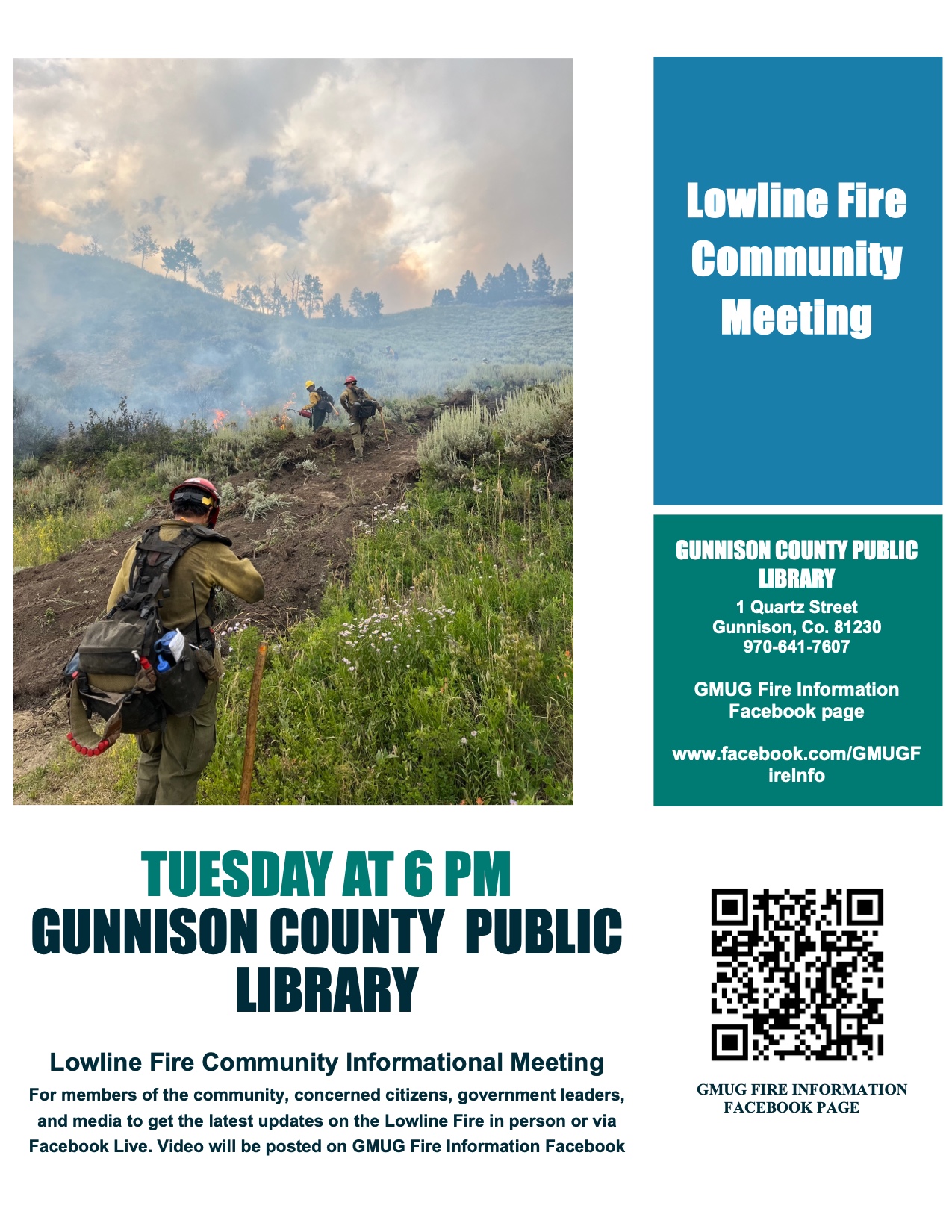
Lowline Fire Community Meeting Tuesday August 1 2023 at 600 pm
Related Incident: Lowline Fire
Publication Type: Announcement
The Lowline Fire is hosting a community informational meeting for members of the community, concerned citizens, government leaders, and media to get the latest updates on the Lowline Fire in person or via Facebook Live. Video will be posted on GMUG Fire Information Facebook.
When: Tuesday, August 1
Time: 6:00 p.m.
Where: Gunnison County Public Library, 1 Quartz St., Gunnison, CO
See the attached flyer for more details.
Salmon River Closed due to Significant Fire Activity July 31 through August 2
Related Incident: Elkhorn Fire
Publication Type: Announcement
The Elkhorn Fire on the Salmon River corridor has become extremely active and is expanding in size daily. As of today, July 31, 2023, there is no launching on the Permitted Salmon River Wilderness section from Corn Creek to Vinegar Creek through Wednesday, August 2, 2023.
The Salmon-Challis National Forest who administers the river permit system is offering boaters affected by this closure a rollover option for next season on the same launch date. In order to allow people time to plan and prepare for their Salmon River trip, given the uncertainty of when the fire activity will allow for boaters to use the Permitted Salmon River in the near future, the Forest Service is offering rollovers to those with trips planned within five days of a closure date.
We will continue to assess the fire activity and will allow boaters to launch as soon as possible.
- For Rollover information and other river information call the Salmon – Challis National Forest River Clerk at 208-756-5587 or 208-481-2625.
The triggers that move us to closing the river corridor are centered around safety to the rafters and the firefighters, and the significance of fire behavior in the immediate area. In our efforts to fight this fire, a large amount of time and resources are consumed in managing the rafters to quickly get through the fire area. Closing the river temporarily allows us to focus on the fire effort.
Regarding the opening of the river, there is not really any good intel we can offer - we do all we can to open the river as quickly as possible with the focus on safety for all. Fire efforts along the main Salmon River have always presented a challenge to firefighters as weather conditions are very unpredictable and often change with very little warning. This everchanging weather cycle added to the dry fuels/vegetation in the area and steep terrain results in wildfire that tends to grow significantly and present safety issues for all.
Anderson Complex Daily Update for July 31 2023
Related Incident: Anderson Complex
Publication Type: News
On Sunday evening, the Teklanika River Fire was reported to be 5,444 acres; the Birch Creek Fire was estimated at 1,167 acres; the Nenana River Fire was 0.2 acres; the Nenana River 2 Fire was 0.1 acres; and the Kobe Road Fire was 0.1 acres. The more accurate acreage for the Kobe Road Fire is the result of improved visibility, reconnaissance flights, and ground assessments conducted Sunday.
The five fires collectively make up the Anderson Complex. Great Basin Team 3 assumed command of the Anderson Complex at 8 a.m. Monday. The team has divided the complex into two branches to better manage the work being done by firefighters and the use of equipment. Branch 1 encompasses the northern half of the complex and includes areas impacted by the Teklanika River Fire (#257) and the city of Anderson. Branch 2 encompasses the southern half of the complex and includes areas impacted by the Birch Creek Fire (#285), Kobe Road Fire (#297), Nenana River Fire (#288), and the Nenana River 2 Fire (#289).
In Branch 1, the Midnight Sun Hotshots are continuing structure protection for cabins and allotments along the Teklanika River. The Suns will be joined today by the Lassen Hotshots. Both crews will continue to protect structures along the Teklanika. Members of the Joint Base Elmendorf-Richardson (JBER) Task Force are building or opening up previously constructed fuel breaks around the city of Anderson. This is a precautionary measure to protect the community from the fire should it move in that direction. In Branch 2, the Shasta Lake Hotshots will work with two engines and two skidgens, which are tracked vehicles, to protect structures north of the Birch Creek Fire.
The members of this group will also focus today on putting out the Kobe Road Fire. Crews have also been tasked with conducting structure assessments in the Anderson subdivision, also known as the North Forties, to develop a plan for protecting them from fire if needed. Fire personnel are also evaluating ways to protect structures along the George Parks Highway and the Nenana River. Fire activity has moderated over the past few days due to cooler, wetter weather. Crews are working to take advantage of this before hot, dry weather moves into the area mid-week.
EVACUATION STATUS: The Teklanika River and all residents within 2.5 miles of the Teklanika River, and all residents adjacent to Rose Hip Creek remain in Evacuation Status GO. Individuals in this area should evacuate now. Do not delay. The Tri-Valley School is available for evacuation parking and will be available as an evacuation center, if needed. The city of Anderson and all residents that use any road west of the George Parks Highway between milepost 270 and the Rex Bridge remain in Evacuation Status SET. Individuals in this area should be ready in a moment’s notice. Visit the Denali Borough website for additional information.
###
Blum Fire Daily Update July 31 2023
Related Incident: Blum Fire
Publication Type: News
Blum Fire Update
Monday July 31, 2023
Size: est. 300 acres
Containment: 95%
Start Date: July 26, 2023
Cause: Under Investigation
The Blum Fire started on July 26, 2023, and was initially responded to by multiple local and county entities. Texas A&M Forest Service was requested to assist at 3:15 p.m. and responded with aviation resources, heavy equipment and engines from Texas A&M Forest Service and Texas Intrastate Fire Mutual Aid System (TIFMAS). Multiple departments from Hill, Johnson and Bosque counties are working in unified command with Texas A&M Forest Service and Texas Division of Emergency Management (TDEM).
Yesterday: Crews continued to engage in mop up operations across the fire area, checking for hotspots or heat that may pose a threat to containment.
Today: Engine crews will patrol the perimeter of the fire and interior roadways, checking for hotspots and working to suppress any active flames and smoking areas. Personnel and equipment will watch for increased fire activity as the afternoon temperatures rise. Aerial resources will be available to respond as needed for suppression.
Weather and Fire Behavior: Excessive hear warning in effect until 8 pm this evening.Hot and dry conditions are expected to continue through Tuesday with high temperatures near 107 and minimum humidity around 20%. Southeast winds around 10 mph can be expected. Mixing heights around 10,00 feet are expected both today and tomorrow. RH recovery is expected to be around 65% early Tuesday morning.
Evacuations: There are currently no evacuations in place.
Damages/Injuries: One outbuilding was confirmed to be destroyed by the fire. No homes have been destroyed by the fire. No injuries have been reported at this time.
Closures: FM Road 933 is now open. Please use caution when traveling along this roadway as fire crews are still working along this road to suppress the Blum Fire.
Fire Information
Information Officer
Texas A&M Forest Service
Email: information@tfs.tamu.edu
Phone: 979-255-0591
Inciweb: https://inciweb.wildfire.gov/incident-information/txtxs-blum-fire
Facebook: https://www.facebook.com/AllHazardsTFS
Twitter: https://twitter.com/AllHazardsTFS